
Where Flight Simulation Enthusiasts Gather from Around the World!
AVSIM Library - Search Results

| Category: Flight Simulator 2002 - Flight Plans | |
| Val-U-Prop Flights April 2003 |

|
File Description:
Over thirty flights, half of them with VOR to VOR IFR/ATC/GPS files, that encompass geography from California to the Berlin Airlift; New England; the American Midwest, Ireland and more. Major airports are included, as well as smaller fields. Many of the flights have instructional value, and emphasize certain procedures. Some are short; some are longer; none are too long. All are pure fun. Text versions compatible with FS98 and FS2000. Brought to you by Val-U-Prop, so bring your brains.
| Filename: | ValUProp_Flights_April_2003.zip |
| License: | Freeware |
| Added: | 1st May 2003, 07:55:00 |
| Downloads: | 378 |
| Author: | James Underwood |
| Size: | 28.31 KB |
| Category: Flight Simulator 2002 - Flight Plans | |
| KABQ Departure flight plans |
|
File Description:
These files contain 34 flight plans using coded departure
routes from the Air Traffic Control System Command Center
(ATCSCC). I have modified only the STAR's that were older
than what I have on my Hard Drive dated 3/03.
These plans are for KABQ departures and are included in the
following formats.....
.sbp - For loading into the Squawkbox FMS
.prg - for loading into ACS GPS
.pln - For loading into the FS flight planner (FS2K2)
.fsn - for loading int FSNaigator (ver. 4+)
| Filename: | KABQ_Departure_flight_plans.zip |
| License: | Freeware |
| Added: | 31st May 2003, 16:23:30 |
| Downloads: | 278 |
| Author: | Michael Fox |
| Size: | 76.58 KB |
| Category: Flight Simulator 2002 - Flight Plans | |
| 42RTWest |
|
File Description:
An FS2002 GPS flight Plan. The 42nd in a series of Round the World flight plans for the FS2002 default scenery. Depart Tabriz (OITT) runway 30R, Iran and arrive 1 hour 04 minutes later at Erzurum (LTCE) runway 26L, Turkey. This is a low level scenic flight (10,000 ft) skimming the mountain tops on route. The flight briefing (Word and text) is for the default B737-400; it contains climb, cruise, top of descent and fuel loading details, waypoint timings and destination details.
| Filename: | 42RTWest.zip |
| License: | Freeware |
| Added: | 9th September 2002, 02:41:35 |
| Downloads: | 673 |
| Author: | The Ancient Brit |
| Size: | 22.27 KB |
| Category: Flight Simulator 2002 - Flight Plans | |
| 33RTWest |
|
File Description:
An FS2002 GPS flight Plan. The 33rd in a series of Round the World flight plans for the FS2002 default scenery. Depart Dibrugarh (VEMN), runway 05, India and arrive 1 hour 52 minutes later at Guwahati (VEGT), runway 02. A climb into the mountains is involved and a descent into a valley before finals. The flight briefing (Word and text) is for a B737-400, it contains climb, cruise, top of descent and fuel loading details, waypoint timings and destination details.
| Filename: | 33RTWest.zip |
| License: | Freeware |
| Added: | 3rd July 2002, 01:39:36 |
| Downloads: | 784 |
| Author: | The Ancient Brit |
| Size: | 29.2 KB |
| Category: Flight Simulator 2002 - Original Aircraft | |
| Cathay Pacific Airways Learjet 45 Ver 2 |
|
File Description:
Freeware GMAX Bombardier Learjet45 for FS2002 Standard or Pro Version. Uses the Lear45 panel and sounds (sounds aliased). Features: full animation using GMAX; full Virtual Cockpit and Virtual Cabin with night lighting; thrust reversers, passenger door, nose wheel steering, spoilerons, main gear taxi lights and Underbelly landing lights that can be controlled separately. Reflective textures. Includes optional Honeywell GPS by Ike H. Slack, Coyote Avionics Design. VH-CXJ is the first of Cathay's Learjets, acquired in 2001 for pilot training.
| Filename: | Cathay_Pacific_Airways_Learjet_45_Ver_2.zip |
| License: | Freeware |
| Added: | 6th July 2002, 01:49:27 |
| Downloads: | 4,807 |
| Author: | Rick Sasala, Mark Beaumont |
| Size: | 2.18 MB |
| Category: Flight Simulator 2004 - Scenery | |
| Lismore Regional Airport (YLIS) update to V1.1 |
|
File Description:
This short update adds a dynamic truck to the GA of Lismore. To see the object start at the GA end and wait for the truck to come past.
I have changed the sensitivity of crash detection on most objects so slewing around the airport will be easier. The terminal for technical reasons is still prone to cause a crash if you stray too close to the terminal.
Corrected is a tendency for FS9 to "crash" when you use the GPS with Lismore.
| Filename: | Lismore_Regional_Airport_YLIS_update_to_V11.zip |
| License: | Freeware |
| Added: | 11th May 2004, 12:37:36 |
| Downloads: | 1,174 |
| Author: | John Ross |
| Size: | 157.06 KB |
| Category: Flight Simulator 2004 - AFCAD Files | |
| RCKH Kaohsiung Intl Taiwan (ROC) enhanced AFCAD |
|
File Description:
Updated RCKH Kaohsiung Intl Airport in Taiwan Republic of China for FS9. Runway 9R/27L is redesignated as Taxiway S and Runway 9L/27R is redesignated as 9/27 per current charts. Parking has also been improved for better airline AI use. In addition to the basic AFCAD file in this update there is a second, enhanced file with taxisigns and all current IFR approaches for GPS, AI, and ATC use. Included is a set of current IAP charts for the airport.
| Filename: | RCKH_Kaohsiung_Intl_Taiwan_ROC_enhanced_AFCAD.zip |
| License: | Freeware |
| Added: | 8th March 2008, 00:07:55 |
| Downloads: | 1,327 |
| Author: | Scott Smart |
| Size: | 1.64 MB |
| Category: Flight Simulator 2004 - Miscellaneous Files | |
| POP "Plans-on-Paper" Nr. 1 |
|
File Description:
Plans on paper is for the real "pure" navigating pilot, no addons, no moving maps and no gps ofcourse ;-)
The file contains one single Excell file with an IFR navigation/log form and one or more maps.
Just print the plan and map(s), complete it with the "actual" wheather and aircraft details and off you go.
You need Excell or another application that read Excell files to be able to read the file and it does some automatic calculation.
| Filename: | POP_PlansonPaper_Nr_1.zip |
| License: | Freeware |
| Added: | 24th October 2008, 00:47:09 |
| Downloads: | 506 |
| Author: | Arjen de Vries |
| Size: | 777.33 KB |
| Category: Flight Simulator X - Scenery | |
| Indian Arm Float Base, Vancouver |
|
Images related to this file:
File Description:
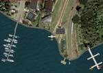
A fictitious day park and float plane base located at the mouth of Indian Arm (river) north-east of downtown Vancouver. Includes a water runway (shows on GPS) and NDB (ADF) with frequency of 225.0 and 60 NM range. Has a float plane and 2 boat docks and many other candies to enhance your FSX world.
This scenery will be a companion to "Vancouver Extras" which is coming very soon. Have great flights to and from this nice place. Enjoy! savageagle
| Filename: | Indian_Arm_Float_Base_Vancouver.zip |
| License: | Freeware |
| Added: | 24th July 2010, 04:57:13 |
| Downloads: | 1,996 |
| Author: | Tim Durham |
| Size: | 1.26 MB |
| Category: Flight Simulator X - Panels | |
| Grumman J2F Duck |
|
Images related to this file:
File Description:
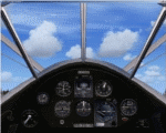
A 4:3 ratio 2D Panel created for SWingman's Grumman J2F Duck in FSX. There are two configurations. One has the normal Compass and Artificial Horizon Indicators, the other has Sperry Compass Heading Autopilot, Sperry AHI Pitch Autopilot and GPS. Both have new Popup windows for the fuel gauges, pedestal, and radios.
I included some new gauges to allow mouse control of the Battery, Elec Fuel Pump, Magnetos, Engine Primer, and Starter in the Virtual Cockpit.
The 2D instrumentation reflects the VC.
| Filename: | Grumman_J2F_Duck.zip |
| License: | Freeware |
| Added: | 18th April 2011, 19:04:46 |
| Downloads: | 280 |
| Author: | Don Bodenstedt |
| Size: | 2.64 MB |
© 2001-2026 AVSIM Online
All Rights Reserved
Privacy Policy |