
Where Flight Simulation Enthusiasts Gather from Around the World!
AVSIM Library - Search Results

| Category: Flight Simulator 2004 - AI Flight Plans | |
| Cape Air Fall 2010 |

|
Images related to this file:
File Description:

Flight Plans for Cape Air and Nantucket
Airlines. All flights are included except
for the flights out of their Guam Hub which
are Continental Connection Flights that have
been covered by other Flight Plan Developers.
1923 Flights includes all flights from Cape
Air Hubs/Bases at Nantucket, Boston, San Juan,
Ft. Myers, St. Louis, Baltimore/Washington,
and Albany. Flight Plans by Jim Martin.
| Filename: | Cape_Air_Fall_2010.zip |
| License: | Freeware |
| Added: | 5th September 2010, 20:53:12 |
| Downloads: | 1,510 |
| Author: | Jim Martin |
| Size: | 35.73 KB |
| Category: Prepar3D V1-4 - Utilities | |
| GENav pro Navigation |
|
Images related to this file:
File Description:

Previous payware product at SimMarket, now 100% free.
With GENav pro you will view all AIRAC navigation data and terminal procedures inside Google Earth. GENav pro run under Windows and require only Google Earth for displaying. You can also edit your own routes or just copy routes into GENav to view in Google Earth. You can search for example an airport or a fix by short or long name, Google Earth will take you there.
You can connect to Microsoft Flight Simulator to view your aircraft. Moving map and heading is available.
GENav pro is highly optimized for best performance and clear views without clutter. There are smart filters to select relevant data to display, all AIRAC items are available. You will find all data such as nav-aid frequencies, airport runways with ILS frequencies by click the displayed icons in Google Earth.
You can edit routes visual direct inside Google Earth by click. The database can always be updated with Navigraph's latest AIRAC data.
With GENav you can easy build valid routes. Unlike other common autorouting program, GENav is the tool for you to build routes with correct airway direction and correct connected to SID/STAR's. You will easy draw your routes most stright and correct to destination. It is also excellent for visual and instrument navigation flights.
FEATURES:
*** Display airports, nav aids, waypoints
*** Display High/Low airways and airways direction
*** Display SID/STAR, Approaches and Transitions
*** Display ARTCC/FIR border
*** AIRAC data available by click
*** Search airport and fixes
*** AIRAC data compatible Navigraph data
*** Visual editable routes
*** VOR to VOR route navigation data
*** Display your aircraft
BASIC SYSTEM REQUIREMENTS:
*** Windows with Google Earth installed
( Notice, no flightsim program required )
OPTIONALLY REQUIREMENTS:
*** SID/STAR require the Navigraph purchase or an alternative free source
*** Airways direction & high/low info require the Navigraph purchase
*** To display aircraft, Microsoft Flight Simulator or Prepare3D v1/v2, with free FSUIPC is required.
*** To display aircraft at a separate computer, also the payware WideFS is required.
| Filename: | GENav_pro_Navigation.zip |
| License: | Freeware |
| Added: | 25th May 2016, 11:24:52 |
| Downloads: | 654 |
| Author: | Lennart Vedin |
| Size: | 4.5 MB |
| Category: Flight Simulator 2004 - Utilities | |
| GENav pro Navigation |
|
Images related to this file:
File Description:

Previous payware product at SimMarket, now 100% free.
With GENav pro you will view all AIRAC navigation data and terminal procedures inside Google Earth. GENav pro run under Windows and require only Google Earth for displaying. You can also edit your own routes or just copy routes into GENav to view in Google Earth. You can search for example an airport or a fix by short or long name, Google Earth will take you there.
You can connect to Microsoft Flight Simulator to view your aircraft. Moving map and heading is available.
GENav pro is highly optimized for best performance and clear views without clutter. There are smart filters to select relevant data to display, all AIRAC items are available. You will find all data such as nav-aid frequencies, airport runways with ILS frequencies by click the displayed icons in Google Earth.
You can edit routes visual direct inside Google Earth by click. The database can always be updated with Navigraph's latest AIRAC data.
With GENav you can easy build valid routes. Unlike other common autorouting program, GENav is the tool for you to build routes with correct airway direction and correct connected to SID/STAR's. You will easy draw your routes most stright and correct to destination. It is also excellent for visual and instrument navigation flights.
FEATURES:
*** Display airports, nav aids, waypoints
*** Display High/Low airways and airways direction
*** Display SID/STAR, Approaches and Transitions
*** Display ARTCC/FIR border
*** AIRAC data available by click
*** Search airport and fixes
*** AIRAC data compatible Navigraph data
*** Visual editable routes
*** VOR to VOR route navigation data
*** Display your aircraft
BASIC SYSTEM REQUIREMENTS:
*** Windows with Google Earth installed
( Notice, no flightsim program required )
OPTIONALLY REQUIREMENTS:
*** SID/STAR require the Navigraph purchase or an alternative free source
*** Airways direction & high/low info require the Navigraph purchase
*** To display aircraft, Microsoft Flight Simulator or Prepare3D v1/v2, with free FSUIPC is required.
*** To display aircraft at a separate computer, also the payware WideFS is required.
| Filename: | GENav_pro_Navigation.zip |
| License: | Freeware |
| Added: | 25th May 2016, 11:24:32 |
| Downloads: | 530 |
| Author: | Lennart Vedin |
| Size: | 4.5 MB |
| Category: Prepar3D V1-4 - Aircraft Repaints, Textures and Modifications | |
| Messerschmitt Bf-109Z Zwilling (13) II.ZG26 |
|
Images related to this file:
File Description:
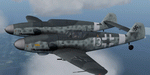
This folder contains a repaint for the Messerschmitt Bf 109Z Zwilling Flight Replicas. It shows an imaginary Bf-109Z of II.ZG26 'Horst Wessel'. Repaint by Jan Kees Blom, based on the paintkit by Flight Replicas.
| Filename: | Messerschmitt_Bf109Z_Zwilling_13_IIZG26.zip |
| License: | Freeware |
| Added: | 27th July 2020, 21:27:39 |
| Downloads: | 28 |
| Author: | Jan Kees Blom |
| Size: | 77.57 MB |
| Category: Flight Simulator 2004 - Flight Plans | |
| Torino-Timisoara |
|
File Description:
Torino-Timisoara Flight Plan, actually operated in real world by Carpatair.
Contains:
- FP in FS2002/FS2004 format (for FS GPS)
- FP in SquawkBox format (for online flight)
- notes regarding the route.
| Filename: | TorinoTimisoara.zip |
| License: | Freeware |
| Added: | 26th September 2004, 04:38:49 |
| Downloads: | 341 |
| Author: | Francesco Garganese |
| Size: | 2.44 KB |
| Category: Flight Simulator 2004 - Flight Plans | |
| Timisoara-Torino |
|
File Description:
Timisoara-Torino Flight Plan, actually operated in real world by Carpatair.
Contains:
- FP in FS2002/FS2004 format (for FS GPS)
- FP in SquawkBox format (for online flight)
- notes regarding the route.
| Filename: | TimisoaraTorino.zip |
| License: | Freeware |
| Added: | 26th September 2004, 04:40:10 |
| Downloads: | 424 |
| Author: | Francesco Garganese |
| Size: | 2.34 KB |
| Category: Flight Simulator 2004 - Flight Plans | |
| Bangkok (VTBD) - Singapore (WSSS) and Singapore (WSSS) - Bangkok (VTBD) for Level-D Sim 767 |
|
File Description:
Two flightplans for the Level-D Sim 767. BKK - SIN and SIN - BKK. I used a online flight planing tool, so the route should be as real as possible. Flight time is about two hours.
| Filename: | Bangkok_VTBD__Singapore_WSSS_and_Singapore_WSSS__B.zip |
| License: | Freeware |
| Added: | 13th March 2005, 19:42:07 |
| Downloads: | 1,687 |
| Author: | Peter Andrew Marten |
| Size: | 1.45 KB |
| Category: Flight Simulator 2004 - AI Flight Plans | |
| Meridiana winter 2005 version 2 |
|
File Description:
FS2004 Meridiana AI Flight Plans for the first week of January 2006.
Requires MRAI Installer can be found at http://aita2004.pvdveen.net/download.htm
Flight plans by Massimiliano Leveratto.
Previous version has more than 510 downloads
| Filename: | Meridiana_winter_2005_version_2.zip |
| License: | Freeware, limited distribution |
| Added: | 1st December 2005, 11:40:50 |
| Downloads: | 986 |
| Author: | Massimiliano Leveratto |
| Size: | 12.08 KB |
| Category: Flight Simulator 2004 - AI Flight Plans | |
| Helvetic Airways Summer 2008 |
|
File Description:
Helvetic Airways AI Flight Plans for summer 2008. All flights are included and made with MRAI compiler. They are tested with Traffic Tools and MRAI Companion. Flight plans start in first week of June 2008.
| Filename: | Helvetic_Airways_Summer_2008.zip |
| License: | Freeware |
| Added: | 14th May 2008, 12:31:21 |
| Downloads: | 656 |
| Author: | Marc Marijnissen |
| Size: | 2.86 KB |
| Category: Flight Simulator 2004 - AI Flight Plans | |
| Edelweiss Air Summer 2008 |
|
File Description:
Edelweiss Air AI Flight Plans for summer 2008. All flights are included and made with MRAI compiler. They are tested with Traffic Tools and MRAI Companion. Flight plans start in first week of July 2008.
| Filename: | Edelweiss_Air_Summer_2008.zip |
| License: | Freeware |
| Added: | 5th June 2008, 20:12:46 |
| Downloads: | 737 |
| Author: | Marc Marijnissen |
| Size: | 3.1 KB |


© 2001-2026 AVSIM Online
All Rights Reserved
Privacy Policy |