
Where Flight Simulation Enthusiasts Gather from Around the World!
AVSIM Library - Search Results

| Category: Flight Simulator X - Aircraft Repaints, Textures and Modifications | |
| LTU "Bayer-Leverkusen" Airbus A320 (D-ALTC) |

|
Images related to this file:
File Description:

This is a repaint of the LTU "Bayer-Leverkusen".
This repaint is dedicated to all the friendly LTU Crew Members, who took us several times to Windhoek!
Textures only, you need to have the feelThere / Wilco Airbus Series Vol1 or Evolution software installed.
Added you will find my sound file for the thrust lever positions to replace the feelThere soundfile.
| Filename: | LTU_BayerLeverkusen_Airbus_A320_DALTC.zip |
| License: | Freeware |
| Added: | 15th October 2015, 17:54:12 |
| Downloads: | 108 |
| Author: | Bernd Schaefer |
| Size: | 10.98 MB |
| Category: Flight Simulator 2004 - Aircraft Repaints, Textures and Modifications | |
| South West Airways Douglas C-47 |
|
Images related to this file:
File Description:
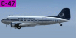
The airline was established in 1946 as South West Air Transport and started operations in 1948. It operated from Windhoek in South West Africa (Namibia). On 26 March 1959, it merged with Oryx Aviation and became South West Airways (Afrikaans - Swidwes Lugdiens). In 1965 Namib Air became the only owner of South West Airways and both companies merged into Namib Air in 1978. Douglas C-47A-I-DK C/N 11991 started life with the USAAF serial number 42-92214 and then became FL583 with the Royal Air Force. Subsequently it was operated by the SAAF as 6871. Next it went to Aircraft Operating Company before joining South West Airways. ZS-DIW was given the name Windhoek. Textures only. Prior installation of Manfred Jahn's outstanding FS2004 Douglas C-47 Base Pack (c-47_basepack_fs9.zip) is required. Repaint by Andre Reimers.
| Filename: | South_West_Airways_Douglas_C47.zip |
| License: | Freeware |
| Added: | 8th June 2011, 00:41:34 |
| Downloads: | 210 |
| Author: | Andre Reimers |
| Size: | 3.91 MB |
| Category: Flight Simulator X - Scenery | |
| Shahjalal International Airport (Zia) v1.0 |
|
File Description:
The biggest Shahjalal International Airport (Zia). Meticulously detailed and realistically depicted Flight Simulator X scenery for Shahjalal International Airport (Zia). Created with 3ds max from scratch, the scenery includes accurate buildings, hangars, parking bays, night texturing and illumination effects. The scenery contains variety of static aircraft and animations and photo real terrain texture. This a complete scenery for FSX. The Shahjalal International Airport (Zia) is the busiest airport in Bangladesh and provides access to 4.6 million passengers a year.
| Filename: | Shahjalal_International_Airport_Zia_v10.zip |
| License: | Freeware |
| Added: | 6th January 2012, 10:06:58 |
| Downloads: | 5,502 |
| Author: | Huseyin Buharali |
| Size: | 14.26 MB |
| Category: Prepar3D V1-4 - Scenery | |
| Piarco International Airport - TTPP V1.2 |
|
File Description:
TTPP v1.2 - In this version, problems with markings in tax lanes have been fixed. The textures of the taxi stands have also been redone. More vehicles and vegetation were included.
Piarco International Airport (IATA: POS, ICAO: TTPP) is an international airport serving the island of Trinidad and is one of two international airports in Trinidad and Tobago. The airport is located 30 km (19 mi) east of Downtown Port of Spain, located in the adjacent town of Piarco. It is the seventh busiest airport in the Caribbean in terms of passengers served[6] and third busiest in the English-speaking Caribbean, after Sangster International Airport and Lynden Pindling International Airport. The airport is also the primary hub and operating base for the country's national airline, as well as the Caribbean's largest airline, Caribbean Airlines.
Piarco International Airport has direct scheduled service to destinations in the United States, Canada, Central America, South America and Europe. It is also a significant transit hub for the Southern Caribbean and serves as the primary connection point for many passengers travelling from Guyana.
| Filename: | Piarco_International_Airport__TTPP_V12.zip |
| License: | Freeware |
| Added: | 4th February 2022, 03:49:10 |
| Downloads: | 558 |
| Author: | Eduardo Puelker |
| Size: | 53.65 MB |
| Category: Flight Simulator X - AFCAD Files | |
| KECP - Northwest Florida Beaches International Airport |
|
File Description:
This airport replace with Panama City-Bay County International Airport - KPFN. New airport just open on May 23, 2010 operating for Delta and SOuthwest Airlines.
| Filename: | KECP__Northwest_Florida_Beaches_International_Airp.zip |
| License: | Freeware |
| Added: | 26th May 2010, 19:07:13 |
| Downloads: | 844 |
| Author: | Gilbert Bowers |
| Size: | 5.11 KB |
| Category: Flight Simulator 2004 - Scenery | |
| LGZA - Dionysios Solomos - Zakynthos, Greece |
|
File Description:
Zakynthos International Airport, "Dionysios Solomos" (IATA: ZTH, ICAO: LGZA) is an airport in Zakynthos, Greece. The airport is located close to the town of Kalamaki.
| Filename: | LGZA__Dionysios_Solomos__Zakynthos_Greece.zip |
| License: | Freeware |
| Added: | 28th November 2014, 20:03:21 |
| Downloads: | 1,151 |
| Author: | Billy Guo |
| Size: | 365.13 KB |
| Category: Fly! II - Miscellaneous Files | |
| Arizona Flight Plan No. 2 |
|
File Description:
This Arizona Adventure starts at the Lauglin/Bullhead International Airport and ends at the Yuman International Airport. The flight plan has a total of 12 airports. Take your time and explore the scenery. Have a fun and safe flight.
| Filename: | Arizona_Flight_Plan_No_2.zip |
| License: | Freeware |
| Added: | 6th August 2003, 03:04:52 |
| Downloads: | 186 |
| Author: | Wayne Roberts |
| Size: | 5.41 KB |
| Category: Fly! II - Miscellaneous Files | |
| KIAH to KSAT |
|
File Description:
This flight plan is from the George Bush International Airport (KIAH) to the San Antonio International Airport (KDFW). Included are waypoints, navaids, approach, departure and runway plates. The flight plan is 227 NM. Also included is a metar file .
| Filename: | KIAH_to_KSAT.zip |
| License: | Freeware |
| Added: | 23rd June 2004, 19:50:34 |
| Downloads: | 94 |
| Author: | Wayne Roberts |
| Size: | 872.46 KB |
| Category: Fly! II - Miscellaneous Files | |
| KORD to KATL Flight Plan |
|
File Description:
This flight plan is from the Chicago O'Hare International Airport (KORD) to the William B. Hartsfield International Airport (KATL). Included are waypoints, navaids, departure and arrival plates. The flight plan is 542 NM. Also included is a metar file .
| Filename: | KORD_to_KATL_Flight_Plan.zip |
| License: | Freeware |
| Added: | 26th July 2004, 03:38:19 |
| Downloads: | 82 |
| Author: | Wayne Roberts |
| Size: | 725.09 KB |
| Category: Fly! II - Miscellaneous Files | |
| KORD to KIAD Flight Plan |
|
File Description:
This flight plan is from the Chicago O'Hare International Airport KORD) to the Washington Dulles International Airport (KIAD) Included are waypoints, navaids and runway and arrival plates. The flight plan is 511 NM. Also included is a metar file .
| Filename: | KORD_to_KIAD_Flight_Plan.zip |
| License: | Freeware |
| Added: | 8th June 2004, 23:50:11 |
| Downloads: | 75 |
| Author: | Wayne Roberts |
| Size: | 545.87 KB |
© 2001-2026 AVSIM Online
All Rights Reserved
Privacy Policy |