
Where Flight Simulation Enthusiasts Gather from Around the World!
AVSIM Library - Search Results

| Category: Flight Simulator X - Scenery | |
| Middle East Carrier Operations (MECOPS) |

|
Images related to this file:
File Description: This scenery has been developed for FSX Flight Simulator SP1 or SP2. It

has also been tested with Microsoft Acceleration , but compatibility is not
guaranteed by the author.
The scenery includes: Two carrier groups CVN68 and CVN69, ( carrier models from
Javier Fernandez ), two AI KC-135 tanker aircraft, AI F-18A aircraft approaching
the carrier, Navy destroyer and a Navy Cruiser as escort ships for the carrier,
a number of oil platforms and the ARS4 radar gauge which displays air targets
and boat targets.
The ARS4 radar gauge provides also a auto landing function for the carrier and a
auto tracking function for aircraft in order to support a A2A re-fueling. The
scenery package includes as well the program Arrcab, developed by Richard Hogan,
and the RCBCO gauge developed by Rob Barendregt. Arrcab or RCBCO are required to
support a catapult start from a carrier and the cable arrestor function for a
carrier landing.
This is not a load and fly package. Please take your time to read the included
documentation for the ARS4 gauge and the MECOPS scenery carefully. Do not skip
chapters because you may think, they are not important for you.
Do not start the installation of the scenery before you have finished the
reading of the documents.
For copyrights and credits please look at the documentation for this scenery.
| Filename: | Middle_East_Carrier_Operations_MECOPS.zip |
| License: | Freeware, limited distribution |
| Added: | 4th March 2013, 18:03:32 |
| Downloads: | 1,892 |
| Author: | Dietmar Loleit |
| Size: | 62.04 MB |
| Category: Flight Simulator X - Gauges | |
| V-One Gauge for Boeing 727-100/200/F (Complete) |
|
Images related to this file:
File Description:
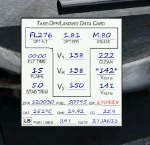
New features in this version are in indicated in '[ ]'.
Twenty call-outs sounds integrated into gauge [13 new call-outs].
Take-off V-Speeds calculated for Flaps 5, 15, or 25 with temperature and altitude adjustments.
[Take-off speed bugs and Command speed bug automatically set for: V1/Vr, V2, V2 + 15].
[Flaps-up maneuvering speed (clean speed) bug set after flaps-up].
Optimum altitude and optimum EPR (EPR calc for M.80) are continually calculated.
Gross Weight overage will display in 'red' text. Tooltip indicates overweight value (LB/KG).
Take-off trim calculated for current gross weight.
Maximum Climb Thrust (MCT) calculated based on current TAT temperature.
[Current EPR displayed adjacent to MCT for ease of use during climb phase].
Display units can be toggled between LB and KG (default LB).
Outside air Temperature can be toggle between Fahrenheit and Celsius.
Resettable fuel use.
Resettable flight timer.
[Selectable Vref landing configurations, Vref30 (default) or Vref40].
[Approach / landing speed bugs and Command speed bug automatically set for: Vref, Vref + 5, Vref + 15].
ZFW, Fuel, CG, Gross Weight and Barometric Pressure MSL (QNH) displayed.
['Barometer Set' call-out occurs when pressing keyboard letter 'B' (V-One gauge must be open)].
[Airspeed gauge enhanced: CMD speed bug colorized orange and notch added for visibly of tick marks below].
[Decision Height adjustment now on Data Card in hidden click-spot located on upper right corner].
[Now installation to a single location will work for all variants].
| Filename: | VOne_Gauge_for_Boeing_727100200F_Complete.zip |
| License: | Freeware, limited distribution |
| Added: | 28th January 2013, 11:30:53 |
| Downloads: | 1,512 |
| Author: | Paul Tally |
| Size: | 3.55 MB |
| Category: Flight Simulator 2004 - Scenery | |
| RAF Wittering 1990 |
|
Images related to this file:
File Description:

Wittering was opened as an RAF station in 1924, but flying here started way back in 1916 with the Royal Flying Corps.
Initially the Central Flying School was based here from 1926 until 1935. During World War 2, Wittering was a part of 12 Group, which was responsible for the defence of the Midlands.
The station took on a nuclear responsibility in 1956 with the arrival of the V-Force Valiants, and later Victor bombers. Because of this, the runway was increased in length.
After the V-Bombers left, the station took on the mantle of Home of the Harrier, a title it carried with it from 1969, until the stations closure in 2010.
This scenery is made up of various library objects, using ScruffyDuck's ADE9X, to make a close representation of the base, as opposed to being factually accurate.
Brian has incorporated most of the extra runways and representations of deck landing areas that were used at Wittering for V/STOL training - these runways are not active, but may still obviously be used for taking off and landing yourself.
Also included are repaints of John Young's Harrier GR3/T4 AI model, available from flightsim.com. These represent the aircraft of No.1(F) Squadron and No.233 OCU, during 1989-90.
There are also a set of representative flightplans to allow the Harriers to fly "typical" missions and flights.
| Filename: | RAF_Wittering_1990.zip |
| License: | Freeware, limited distribution |
| Added: | 6th October 2013, 17:17:42 |
| Downloads: | 1,392 |
| Author: | Brian Clarke, Daryl Payne |
| Size: | 20.58 MB |
| Category: Flight Simulator X - Gauges | |
| V-One Gauge for Milviz Boeing 737-200 v2.0 |
|
File Description:
The following changes are in this version release:
1) All pilot/co-pilot call-outs replaced
2) V-One XML code and sound file logic updated
3) Altitude Call-Out XML code re-written & optimized
4) Corrected setting of Airspeed Cursor when SP177 is in use during approach phase
5) Added Call-out sound toggle for: 'All', 'Altitude' or 'Off' (box in upper right of Data Card)
6) Added 'Current %N1' display to Data Card
List of features: Approximately 40 sounds integrated into gauge. Take-off V-Speeds calculated for Flaps 1, 2, 5, 10, 15 or 25 including temperature and altitude correction. Take-off speed bugs and command speed bug automatically set for: V1, Vr, V2, V2 + 15 and flaps-up maneuvering speed (clean speed). Optimum altitude and optimum EPR (EPR calc for M.74) continually calculated. Flap mis-configuration is displayed in text. Tooltip indicates overweight value (LB/KG). Take-off trim calculated for current gross weight. Current Altitude, EPR, Speed (knts), Flaps and Trim displays via toggle. Display units can be toggled between LB and KG (default LB). Re-settable flight timer. Re-settable fuel use. Selectable Vref landing configurations, Vref15, Vref30 (default) or Vref40. Approach / landing speed bugs and Command speed bug automatically set for: Vref, Vref + 5, Vref + 15 and flaps-up maneuvering speed (clean speed). ZFW, Fuel, CG, Gross Weight and Barometric Pressure MSL (QNH) displayed.
| Filename: | VOne_Gauge_for_Milviz_Boeing_737200_v20.zip |
| License: | Freeware, limited distribution |
| Added: | 1st November 2015, 18:35:29 |
| Downloads: | 2,440 |
| Author: | Paul Tally |
| Size: | 4.11 MB |
| Category: X-Plane - Original Aircraft | |
| China Clipper Martin M-130 for X-Plane 6.40/6.51 |
|
File Description:
China Clipper or Martin M130 for X-Plane 6.40/6.51 - Built by the Martin Company for Pan American Airlines, they were known by the company as Martin Ocean Transports. Only three of these aircraft were built, the China Clipper, the Philippine Clipper and the Hawaii Clipper. To the public, China Clipper became a generic name and originally was applied to all three of the Martin M-130's in Pan Am's fleet and, later, even to the Boeing B-314's which came later. With 4-950 HP radial engines giving a cruising speed of 163 mph and with a range in excess of 3200 miles the "Clippers" were used in the pacific by Pan Am. The "China Clipper" on November 22, 1935 inaugurated the first trans-pacific postal service with 111,000 letters; it returned to San Francisco on December 6, 1935. In 1936 the Hawaii Clipper and Philippine Clipper inaugurated paying passenger service to the Philippines and Hong Kong respectively. These were the original "Clippers" for those including the Boeing B134 to follow. Look for the B134 soon for X-Plane. Just a note : since landing gear skids are used for the wing braces X-Plane thinks that the plane has landing gear and will actually place it on the ground at the airport you select, choose an airport near water and then request a seaplane takeoff or pick a location and altitude on the regional or planet map.
| Filename: | China_Clipper_Martin_M130_for_XPlane_640651.zip |
| License: | Freeware, limited distribution |
| Added: | 11th February 2003, 05:51:20 |
| Downloads: | 1,327 |
| Author: | Robert App |
| Size: | 1.13 MB |
| Category: Orbiter - Miscellaneous Files | |
| Venus Atmosphere and Surface Enhancement 1.0 |
|
File Description:
This addon gives Venus a facelift. As it stands in the current Venus in Orbiter, there is no actual clouds on the planet. In fact, the clouds are actually painted on the surface! If you ever wanted to fly a space probe to explore the surface of Venus, you would be dissapointed. It looks bland with no clouds (in fact, you get perpetual sunshine and clear, stary nights!) and landing on an orange surface with no features at all. This enhancement pack adds the actual cloud layers to the planet and also gives surface features and texture. So now, you get to see what it looks like from underneith the clouds, instead of just landing on them.
The real planet is covered with a perpetual cloud cover of carbon dioxide, amonia, and sulfuric acid. Quit inhospitable to both human life and equiptment. This addon also gives a realistic starless nighttime. The amount of light that reaches the surface of Venus is shown to be that of Earth on a heavy overcast day. This addon looks pretty much like it would be if you were actually decending to the surface of Venus. These clouds in the addon are not just "static", they actually drift in about the same speed as on the real planet. If on the surface or looking out in space, accellerate your time to 10,000 or 100,000 and you will see the clouds move!
| Filename: | Venus_Atmosphere_and_Surface_Enhancement_10.zip |
| License: | Freeware |
| Added: | 7th May 2003, 20:22:18 |
| Downloads: | 1,502 |
| Author: | Jim Williams |
| Size: | 4.43 MB |
| Category: Flight Simulator 2004 - AFCAD Files | |
| RFS New improved and realistic Afcads for TNCM,TFFJ, and SABA/TNCS |
|
File Description:
Make the three FlyTampas airports even more realistic. These Files are for Flight simulator enthusiasts, who prefer realism. These Afcads are optimized for AI Traffic. FlyTampas FlyMarten is very realistic yet, but these files even optimize this very good scenery addon.
These files are improved afcads for the three FlyTampa FlyMarten airports St. Marten (TNCM), St. Barthélemy (TFFJ) and Saba (SABA/TNCS). They are on the basis of the three original afcads from Flytampa, but there are a few differences between the old and the new version: 1. AI Traffic does not make the u-turns in the grass, but they make the u-turns on the provided u-turn areas at the ends of the runways 9 in TNCM, 10 in TFFJ and 12 und 30 SABA. 2. Landing and Takeoff on runway 27 in TNCM and Takeoff on runway 28 in TFFJ is forbidden; it is not possible to prohibit landing, but allow takeoff. So I compound, that all flight movements in TNCM will be performed on RWY 9. 3. At all of the three airports tower frequencies replace AFT, e. g. "Saba Traffic". 4. In SABA and TFFJ I removed few gates, because the pushbacking aircrafts taxied into each other when using the old file. Important: These Files are functional only if FlyTampa-Marten is installed on your computer. There are also the original files in the backup folder.
RFS Real Flight Simulation
| Filename: | RFS_New_improved_and_realistic_Afcads_for_TNCMTFFJ.zip |
| License: | Freeware |
| Added: | 13th August 2008, 19:39:19 |
| Downloads: | 1,802 |
| Author: | Ernst Kamuschke |
| Size: | 1.8 MB |
| Category: Dovetail Games Flight Sim World - Scenery | |
| LEMR - Aerodromo de La Morgal, Oviedo (Asturias, Spain) version 12 |
|
Images related to this file:
File Description:
With ADE v1.65, I have made a few minor arrangements in my previous FSX-P3Dv4 version of this airfield, and I hope it works in Dovetail Flight Simulator World.
This is a basic scenery for LEMR La Morgal, enhanced in order to make it less sad than the default one, and a few more similar to the Google recent photos. I hope with this file your GA AI Traffic can have place for taking off, landing, refueling and sleeping.
You can use as a Navigation Aid the MW Radio Antenna of Mount Naranco, placed between the airfield and the City of Oviedo, by tuning 729 kHz in yor ADF (Thanks to Francisco Sanchez 'Pacoldfield' for suggesting me this improvement).
| Filename: | LEMR__Aerodromo_de_La_Morgal_Oviedo_Asturias_Spain.zip |
| License: | Freeware |
| Added: | 10th April 2018, 17:56:49 |
| Downloads: | 35 |
| Author: | Felix Fernandez de Castro |
| Size: | 89.53 KB |
| Category: Flight Simulator X - Aircraft Repaints, Textures and Modifications | |
| Zambia Airways 737-2Q9 1985 |
|
Images related to this file:
File Description:
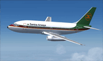
This is a repaint of the 737-2Q9 in Zambia Airways colors. The freeware 737-200 Tinmouse is needed for this repaint. Zambia Airways first operated the 737-200 in 1975. Overall they operated 5 of the type from 1975 to 1991. 9J-AEG was purchased new from Boeing in 1976 and stayed with the airline during its exisence. In 1995 it was sold toVASP of Brazil. Unluckilly for VASP, it was written off in 2003 when it hit a tree on landing in fog, and the gear collapsed. There were no casualties. Textures are 32bit dds. This repaint was tested on FSX-SE. It should also work on FSX & P3D v1-3.
| Filename: | Zambia_Airways_7372Q9_1985.zip |
| License: | Freeware |
| Added: | 22nd August 2019, 08:33:34 |
| Downloads: | 84 |
| Author: | Ted Giana |
| Size: | 4.75 MB |
| Category: Prepar3D V1-4 - Scenery | |
| KSDF - Louisville Intl, Kentucky, USA |
|
Images related to this file:
File Description:
This is Ray Smith's FSX file. Ray has given me permission to modify his file for P3Dv4 and is a reasonably accurate version for Louisville Intl airport to reflect today's situation with two optional files: one version with the Crosswind runway operating where all 3 runways will be used for takeoff/landing and one version as the default airport runway operation. Assigned parking at the terminal now as per their website. The UPS cargo ramp buildings have been completely replaced with something better than the stock airport as well as the Fedex ramp. Taxiways and taxi signs updated and corrected to the latest charts. Extra fuel trucks, support vehicle roads rebuilt and many other scenery improvements and objects added.
| Filename: | KSDF__Louisville_Intl_Kentucky_USA.zip |
| License: | Freeware |
| Added: | 5th March 2018, 22:28:36 |
| Downloads: | 17,195 |
| Author: | Robert Catherall |
| Size: | 6.38 MB |


© 2001-2026 AVSIM Online
All Rights Reserved
Privacy Policy |