
Where Flight Simulation Enthusiasts Gather from Around the World!
AVSIM Library - Search Results

| Category: Flight Simulator X - Miscellaneous Files | |
| Morocco VFR - HLX Coastline |

|
Images related to this file:
File Description:
Re-design coastline of the Morocco to complement my previous Terrain Mesh SRTM 1 Arc/Sec version 3 LOD11 volume 1 and 2. Fully compatible also with P3D.
| Filename: | Morocco_VFR__HLX_Coastline.zip |
| License: | Freeware |
| Added: | 31st May 2015, 21:12:18 |
| Downloads: | 1,437 |
| Author: | Giovanni Miduri |
| Size: | 3.62 MB |
| Category: Flight Simulator X - Scenery | |
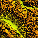
| Morocco VFR - Terrain Mesh SRTM 1 Arc/Sec version 3 - Volume 01 |
|
Images related to this file:
File Description:
Enhanced Terrain Mesh from data souce SRTM 1 Arc/Sec (30 meters) version 3 at LOD 11 (19mt meters/pixel). Coverage: Lat 31 to 37. Fully compatible also with P3D.
| Filename: | Morocco_VFR__Terrain_Mesh_SRTM_1_ArcSec_version_3_.zip |
| License: | Freeware |
| Added: | 22nd March 2015, 00:24:59 |
| Downloads: | 2,288 |
| Author: | Giovanni Miduri |
| Size: | 415.75 MB |
| Category: Flight Simulator 2002 - Scenery | |
| Quebec - New Lake Elevation Corrections |
|
File Description:
The file in this package contains the third update correcting some new lake elevations for Quebec terrain mesh (FS2002) created from SRTM-3 : about 460 lakes between Saguenay and Manicouagan rivers.
| Filename: | Quebec__New_Lake_Elevation_Corrections.zip |
| License: | Freeware, limited distribution |
| Added: | 27th June 2003, 13:16:26 |
| Downloads: | 1,227 |
| Author: | Gilles Gauthier |
| Size: | 457.88 KB |
| Category: Flight Simulator 2004 - Scenery | |
| Romania Mesh |
|
File Description:
Well, the mesh covers the complete Romanian territory - made with the data of ESA/NASA and processed by the SRTM global processor and sampled at 3 arcseconds. Give it a try!
| Filename: | Romania_Mesh.zip |
| License: | Freeware, limited distribution |
| Added: | 11th November 2003, 19:34:55 |
| Downloads: | 6,505 |
| Author: | Stefan Braunewell |
| Size: | 56.06 MB |
| Category: Flight Simulator X - Scenery | |
| Morocco VFR - Terrain Mesh SRTM 1 Arc/Sec version 3 - Volume 02 |
|
Images related to this file:
File Description:
Enhanced Terrain Mesh from data souce SRTM 1 Arc/Sec (30 meters) version 3 at LOD 11 (19mt meters/pixel). Coverage: Lat 27 to Lat 31. Fully compatible also with P3D.
| Filename: | Morocco_VFR__Terrain_Mesh_SRTM_1_ArcSec_version_3_.zip |
| License: | Freeware |
| Added: | 22nd March 2015, 17:54:09 |
| Downloads: | 1,662 |
| Author: | Giovanni Miduri |
| Size: | 279.12 MB |
| Category: Flight Simulator 2004 - Scenery | |
| Nashville Area Mesh |
|
File Description:
This is a mesh file that includes the immediate Nashville International Airport (KBNA) area. It is from N036W87 & N036W86 SRTM data information. This is produced using the 1 Arc per Sec method.
| Filename: | Nashville_Area_Mesh.zip |
| License: | Freeware |
| Added: | 24th November 2003, 20:59:20 |
| Downloads: | 2,195 |
| Author: | Larry Stewart |
| Size: | 6.72 MB |
| Category: Flight Simulator 2004 - Scenery | |
| Scenery Fuerstenfeldbruck - Airbase ETSF (Germany) |
|
File Description:
Airbase ETSF "Fürsty" in southern Germany, now also used by sport aviators.
Some AI-Traffic included. Compatible with Burkhard Renks "Landclass Germany" and Werner Vogts "SRTM scenery mesh". Only tested in FS2004.
| Filename: | Scenery_Fuerstenfeldbruck__Airbase_ETSF_Germany.zip |
| License: | Freeware |
| Added: | 8th April 2004, 23:21:15 |
| Downloads: | 2,584 |
| Author: | Johannes Oelmaier |
| Size: | 2.51 MB |
| Category: Flight Simulator 2004 - Scenery | |
| "Himalayan Peaks" LOD10 Mesh, Volume 4 - Annapurna |
|
Images related to this file:
File Description:

Highly detailed terrain mesh of the Annapurna area, N28-30 E83-85. The files in this package are based on Shuttle Radar (SRTM) Version 2 data but with many of the void areas, especially the most significant sections, filled with elevation data generated from topographic maps by Jonathan de Ferranti. While Jonathan's work is unrelated to flight simulation he kindly gave me permission to compile his data for use in FS. The result is a wonderful improvement in detail and accuracy over any existing mesh file, freeware or commercial, based on SRTM or DTED data alone.
Due to the large area of the Himalayas I've compiled the source data as two separate series: the "Himalayan Peaks" series covers prominent mountains and ranges in higher detail and locally overrides any existing LOD9 terrain mesh. In addition, a LOD9 "base mesh" series covering the entire Himalayas will be available for those who do not yet have an add-on terrain mesh of these beautiful mountains.
| Filename: | Himalayan_Peaks_LOD10_Mesh_Volume_4__Annapurna.zip |
| License: | Freeware, limited distribution |
| Added: | 29th May 2010, 08:59:29 |
| Downloads: | 10,459 |
| Author: | Holger Sandmann, Jonathan de Ferranti |
| Size: | 15.07 MB |
| Category: Flight Simulator 2004 - Scenery | |
| "Himalayan Peaks" LOD10 Mesh, Volume 7 - K2 and Karakoram |
|
Images related to this file:
File Description:

Highly detailed terrain mesh of the Karakoram area, N35-37 E73-77. The files in this package are based on Shuttle Radar (SRTM) Version 2 data but with many of the void areas, especially the most significant sections, filled with elevation data generated from topographic maps by Jonathan de Ferranti. While Jonathan's work is unrelated to flight simulation he kindly gave me permission to compile his data for use in FS. The result is a wonderful improvement in detail and accuracy over any existing mesh file, freeware or commercial, based on SRTM or DTED data alone.
Due to the large area of the Himalayas I've compiled the source data as two separate series: the "Himalayan Peaks" series covers prominent mountains and ranges in higher detail and locally overrides any existing LOD9 terrain mesh. In addition, a LOD9 "base mesh" series covering the entire Himalayas will be available for those who do not yet have an add-on terrain mesh of these beautiful mountains.
| Filename: | Himalayan_Peaks_LOD10_Mesh_Volume_7__K2_and_Karako.zip |
| License: | Freeware, limited distribution |
| Added: | 30th May 2010, 09:56:27 |
| Downloads: | 9,473 |
| Author: | Holger Sandmann, Jonathan de Ferranti |
| Size: | 38.58 MB |
| Category: Flight Simulator 2004 - Scenery | |
| "Himalayan Peaks" LOD10 Mesh, Volume 6 - Jammu and Kashmir |
|
Images related to this file:
File Description:
Highly detailed terrain mesh of the Jammu and Kashmir areas, N31-36 E76-78. The files in this package are based on Shuttle Radar (SRTM) Version 2 data but with many of the void areas, especially the most significant sections, filled with elevation data generated from topographic maps by Jonathan de Ferranti. While Jonathan's work is unrelated to flight simulation he kindly gave me permission to compile his data for use in FS. The result is a wonderful improvement in detail and accuracy over any existing mesh file, freeware or commercial, based on SRTM or DTED data alone.
Due to the large area of the Himalayas I've compiled the source data as two separate series: the "Himalayan Peaks" series covers prominent mountains and ranges in higher detail and locally overrides any existing LOD9 terrain mesh. In addition, a LOD9 "base mesh" series covering the entire Himalayas will be available for those who do not yet have an add-on terrain mesh of these beautiful mountains.
| Filename: | Himalayan_Peaks_LOD10_Mesh_Volume_6__Jammu_and_Kas.zip |
| License: | Freeware, limited distribution |
| Added: | 29th May 2010, 08:55:43 |
| Downloads: | 9,661 |
| Author: | Holger Sandmann, Jonathan de Ferranti |
| Size: | 52.19 MB |
© 2001-2026 AVSIM Online
All Rights Reserved
Privacy Policy |