
Where Flight Simulation Enthusiasts Gather from Around the World!
AVSIM Library - Search Results

| Category: Flight Simulator X - Scenery | |
| FMCZ Pamandzi and the Island of Mayotte. |

|
Images related to this file:
File Description:
Scene of the island of Mayotte in its entirety with its airport (FMCZ Pamandzi / Dzaoudzi).
The mesh for FSX SP1 Hely Heck Junior and Jose Lobo - madmshfx.zip - is necessary.
This scene was designed for FSX (Sp1) by default, it has not been tested with FS9
Airport (FMCZ) present in the scene is served by Air Austral, Air Madagascar, Comoros Aviation Mauricius Air, Kenya Airways, African Express Airways and Air Comores International.
| Filename: | FMCZ_Pamandzi_and_the_Island_of_Mayotte.zip |
| License: | Freeware |
| Added: | 29th December 2010, 21:54:53 |
| Downloads: | 3,280 |
| Author: | CLAUZE Norbert |
| Size: | 1002.62 KB |
| Category: Flight Simulator 2004 - Scenery | |
| Rarotonga International Airport, Cook Islands. NCRG. |
|
File Description:
Welcome to Rarotonga, in the beautiful Pacific Island paradise of the Cook Islands.
This scenery is designed and built to fit the RBE / Sim Pilot Experience "Cook Islands Scenery" (payware), by Christian Stock.
It has not been tested in the freeware Cook Islands Mesh that is available, or in FS9 default.
Scenery contains some custom items (textures included). Scenery requires some EZ Scenery Object Sets (see INSTALL instructions for details).
| Filename: | Rarotonga_International_Airport__Cook_Islands__NCR.zip |
| License: | Freeware, limited distribution |
| Added: | 22nd January 2009, 15:25:51 |
| Downloads: | 1,625 |
| Author: | Lawrie Roache |
| Size: | 1.89 MB |
| Category: Flight Simulator X - Scenery | |
| Chatham Islands for Vector Land Class New Zealand |
|
Images related to this file:
File Description:
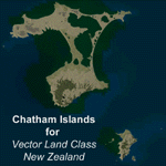
This project is a modified version of the Chatham_Islands.zip project which allows my landclass and airports to work seamlessly with the free Chatham Islands scenery available from Vector Land Class New Zealand. This package allows the user to switch back and forth easily between the different scenery combinations and also provides standalone Chatham and Pitt Island airports which can be used with the Vector Land Class (VLC) scenery on its own. It also allows the user to take advantage of the 15m terrain mesh and added water detail that comes with the VLC scenery. A modified Pitt Island AI runway is also included that is compatible with the 15m mesh. Chatham Islands/Tuuta Airport (NZCI), Napier (NZNR), and the Pitt Island Airstrip (NZPI) are included here. Scenery was created using Airport Design Editor X v1.47.07, SBuilderX 3.13, and the FSX Object Placement Tool. Scenery objects were added and modified from stock FSX scenery to resemble as closely as possible the actual airports.
| Filename: | Chatham_Islands_for_Vector_Land_Class_New_Zealand.zip |
| License: | Freeware |
| Added: | 15th July 2011, 21:54:43 |
| Downloads: | 931 |
| Author: | Carlyle Sharpe |
| Size: | 3.78 MB |
| Category: Flight Simulator 2004 - Scenery | |
| Exploring Mt Rainier Natl Park v1.1 |
|
File Description:
Exploring Mt Rainier Natl Park v1.1
UPDATE! Includes missing textures which resulted in some users experiencing CTD and freezes. A complete remapping of Mount Rainier National Park in Washington State. Based upon commercial topographic maps, the designed scenery includes, every hiking trail drawn in meticulous detail including every real life switchback; every lake and small alpine pond 20 feet in diameter and over, modified landclass of alpine, forest & rock; every perennial and many intermittent creeks, all steams and rivers (many braided), a complete glacier mapping of every glacier with custom textures and ice fields on the mountain, a complete mapping of all rock faces and rock, moraine rock deposits, glacier outwash area, mudflows, roads, swamp and marsh areas. Includes some effects. Designed to compliment UT USA and any LOD 9 or 10 mesh. Works well with FS Genesis LOD 10 mesh and Birds Eye View Textures. By Bryan Wallis and Lou Frost.
| Filename: | Exploring_Mt_Rainier_Natl_Park_v11.zip |
| License: | Freeware, limited distribution |
| Added: | 18th February 2006, 23:14:40 |
| Downloads: | 4,149 |
| Author: | Bryan Wallis & Lou Frost |
| Size: | 11.61 MB |
| Category: Flight Simulator X - Scenery | |
| Bella Coola Valley Landscape Enhancements |
|
File Description:
One of the most spectacular watersheds of British Columbia's Midcoast, the Bella Coola Valley looks pretty boring in its default FSX rendition and the oddly shaped default Bella Coola River cuts deep into the terrain. These files provide a terrain mesh made from CDED1 0.75-arcsec data (multi-LOD, with maximum resolution of 38-m grid spacing), updated land class, water class, and seasons files, and accurate placements of lakes, rivers, streams, roads, and bridges. Also added are the glaciers of the Monarch Mountain Icefield as well as several forestry roads and clearcuts in the side valleys. Main roads have vehicle traffic moving in both directions. Coverage area is N51*45'-52*40' and W125*35'-127*25'. These files are fully compatible with other landscape enhancements for FSX, such as FS Genesis North America terrain mesh, Cloud 9's X-class, Adam Mill's ground texture replacements, or Flight1's Ultimate Terrain Canada/Alaska.
| Filename: | Bella_Coola_Valley_Landscape_Enhancements.zip |
| License: | Freeware, limited distribution |
| Added: | 24th February 2007, 08:27:54 |
| Downloads: | 12,654 |
| Author: | Holger Sandmann |
| Size: | 15.68 MB |
| Category: Flight Simulator 2004 - Miscellaneous Files | |
| Ethiopia - Ras Dashen (Highest Mountains Package 003) |
|
File Description:
This is the flight package "003 Ethiopia Ras Dashen" of the series "Highest Mountains - of all Countries of the World". Flying around for sightseeing is one of the countless options you can do with MS Flight Simulator 2004. Mountain areas are a good choice for looking around, especially if you have a high quality mesh available for those areas. Why not travel to the highest mountain of each country of the world and have a flight from a near airfield up to the roof. With this flight package you will get a ready to fly programmed flight file, including a flight plan for GPS, an interactive map within the kneeboard using GoogleMaps showing the flight path while flying, a weather file generated with ActiveSky 6.5, GPS measured airfields, high quality mesh data for this area, a lot of GA traffic flying around, AI helicopters (not with this package) flying around and coming close to you and some other cool effects you will discover while flying.
| Filename: | Ethiopia__Ras_Dashen_Highest_Mountains_Package_003.zip |
| License: | Freeware |
| Added: | 6th October 2007, 13:55:52 |
| Downloads: | 446 |
| Author: | Gerhard Scheuerecker |
| Size: | 40.04 MB |
| Category: Flight Simulator 2004 - Scenery | |
| Quebec sceneries Enhancements |
|
File Description:
The files in this package contain enhanced sceneries of the province of Quebec, Canada (for FS2004 only). It's update for some islands of St.Lawrence river with much more new enhanced sceneries (see file list in Files_List.txt). Must be used with new terrain mesh for parts of the province of Quebec : QC09_2k4a.zip to QC09_2k4d.zip in AVSIM library.
Les fichiers contenus dans cette archive sont une mise � jour des sc�¨nes des �®les du fleuve Saint-Laurent avec un ajout important de nouvelles sc�¨nes. Vous en trouverez la liste compl�¨te dans le fichier �«Liste_fichiers.txt�». Pour ces sc�¨nes, l'utilisation du nouveau mesh du Qu�©bec pour FS2004 est indispensable. Vous les trouverez dans la biblioth�¨que d'AVSIM. Ils sont archiv�©s en quatre (4) parties : QC09_2k4a.zip � QC09_2k4d.zip.
| Filename: | Quebec_sceneries_Enhancements.zip |
| License: | Freeware, limited distribution |
| Added: | 1st November 2009, 06:48:12 |
| Downloads: | 4,960 |
| Author: | Gilles Gauthier |
| Size: | 4.15 MB |
| Category: Flight Simulator X - Scenery | |
| Cape_Verde_Mesh |
|
File Description:
To improve performance, FSX updated with SP1 loads DEM files in threads and only
the closer terrain (about 10 NM from the point of view) is rendered in high
detail, while at far distances FSX shows up its default low resolution mesh,
if it is not available a multi-resolution one. This terrain mesh file was multilod compiled from 90m SRTM2 source data, reprocessed with 3DEM to remove voids and spikes, providing a 76.4m (LOD9) horizontal resolution topography intended
for use only in FSX updated with SP1.
It covers the Cape Verde, a group of islands in the North Atlantic Ocean, that consist of two small archipelagos, about 400 miles off the western coast of Senegal (Africa), including: Boa Vista, Brava, Maio, Mosteiros, Paul, Praia, Porto Novo, Ribeira Grande, Sal, Santa Catarina, Santa Cruz, Sao Domingos, Sao Filipe, Sao Miguel, Sao Nicolau, Sao Vicente and Tarrafal (Geographic coordinates: 16ºN/24ºW).
Authors:
Hely Heck Junior - Magrao ( [email protected] ) and Jose Lobo (
[email protected] ) TerraBrasilis: www.terra-brasilis.org
| Filename: | Cape_Verde_Mesh.zip |
| License: | Freeware |
| Added: | 21st June 2007, 16:26:23 |
| Downloads: | 4,334 |
| Author: | Hely Heck Jr. and José Lôbo |
| Size: | 1.55 MB |
| Category: Flight Simulator 2004 - Scenery | |
| Airstrips of Central Germany |
|
Images related to this file:
File Description:

Another selection in my Airstrips of Western Europe project, herewith 80+ small airfields in central Germany, each enhanced with taxiways, parking spaces, buildings etc. and aprons as appropriate, to further facilitate the generation of lightweight AI traffic in the area, without overloading the more major airfields.
Again, there's no photo-realism here, just a selection of basic 'generic' buildings, more or less accurately sized and placed to reflect the airfield layout as seen on on-line satellite imagery and aerial photography. These buildings have minimal effect on frame-rates, so are ideal for this kind of job. The airfields are aligned as well as possible with the roads etc. in UT Europe and the Genesis Europe mesh, but should mostly be fine in a default installation or other configuration.
As before, the files for each airfield can be easily identified by the ICAO code, even if the airfield names vary slightly, so you can pick and choose and mix and match to suit any sceneries you already have, should you so wish. There is no requirement for any other download. Each airfield will exist as a stand-alone entity should you only want a few of them.
Please read the rest of this "blurb" in the included text file. There may be some details of note or interest.
| Filename: | Airstrips_of_Central_Germany.zip |
| License: | Freeware |
| Added: | 26th February 2025, 19:22:06 |
| Downloads: | 111 |
| Author: | Chris Eve |
| Size: | 1.14 MB |
| Category: Flight Simulator 2004 - AFCAD Files | |
| LGAT Version 2 |
|
File Description:
Update for previous version. Fixes some bugs and improves the general layout of the airport.
This file sets Athens Athinaikon (LGAT) to the state found at an picture at airliners.net. Today, LGAT, the former main airport of Athens, is closed and replaced by LGAV - Athens Venizelos. The western part of the airport seems to be demoslished and half-way being replaced by a park. On the eastern part, some retired 747-200, 727 and DC3 of Olympic Airlines wait for their destruction. This AFCAD keeps half of the airport usable, enough to house some GA traffic and a few airliners as a buffer. This airport is only based on one single picture at airliners.net. It doesn't keep it's earlier functionality (of the 1990's) as there are only a few parking positions left.
| Filename: | LGAT_Version_2.zip |
| License: | Freeware |
| Added: | 4th January 2004, 11:22:50 |
| Downloads: | 1,100 |
| Author: | Felix Hippmann |
| Size: | 5.96 KB |


© 2001-2026 AVSIM Online
All Rights Reserved
Privacy Policy |