
Where Flight Simulation Enthusiasts Gather from Around the World!
AVSIM Library - Search Results

| Category: Prepar3D V1-4 - Scenery | |
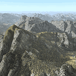
| ITALY ETM20m - Enhanced Terrain Mesh vol. 01 |

|
Images related to this file:
File Description:
Italy - ETM Enhanced Terrain Mesh 0.73 arc sec (20 meters). This Terrain Mesh is fully compatible with FSX/P3D (all versions). This is a work in progress. Volume 01 - Calabria.
| Filename: | ITALY_ETM20m__Enhanced_Terrain_Mesh_vol_01.zip |
| License: | Freeware |
| Added: | 17th December 2018, 23:45:54 |
| Downloads: | 334 |
| Author: | Giovanni Miduri |
| Size: | 23.51 MB |
| Category: Flight Simulator 2004 - Scenery | |
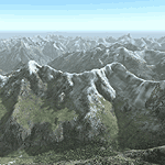
| Alps LOD10 Topo Mesh - Austria and Italy |
|
Images related to this file:
File Description:
Yet another terrain mesh package of the European Alps? Well, this one is different in that it is NOT primarily based on the Shuttle Radar (SRTM) data with their incomplete coverage of prominent peaks and ridges. Instead, most of the source data for this project were developed over many months by Jonathan de Ferranti using detailed topographic maps. While Jonathan's work is unrelated to flight simulation he kindly gave me permission to compile his data for use in FS. The result is a wonderful improvement in detail and accuracy over any existing SRTM- or DTED-based mesh file, freeware or commercial (a link to an extensive set of screenshot comparisons is included in the read-me file).
I've compiled the source data at LOD10 (38-m) grid resolution because the coverage area is smaller than most existing mesh files. Thus, anyone can use these files without having to first uninstall their current mesh set. Also included are LOD9 and LO8 buffer mesh files. Note: if you own Austria Professional 2004 with its 1:50,000 scale terrain mesh then you don't need this package!
| Filename: | Alps_LOD10_Topo_Mesh__Austria_and_Italy.zip |
| License: | Freeware, limited distribution |
| Added: | 30th May 2010, 09:46:58 |
| Downloads: | 62,950 |
| Author: | Holger Sandmann, Jonathan de Ferranti |
| Size: | 73.32 MB |
| Category: Flight Simulator 2004 - Scenery | |
| Alps LOD10 Topo Mesh - Switzerland and France |
|
Images related to this file:
File Description:
Yet another terrain mesh package of the European Alps? Well, this one is different in that it is NOT primarily based on the Shuttle Radar (SRTM) data with their incomplete coverage of prominent peaks and ridges. Instead, most of the source data for this project were developed over many months by Jonathan de Ferranti using detailed topographic maps. While Jonathan's work is unrelated to flight simulation he kindly gave me permission to compile his data for use in FS. The result is a wonderful improvement in detail and accuracy over any existing SRTM- or DTED-based mesh file, freeware or commercial (a link to an extensive set of screenshot comparisons is included in the read-me file).
I've compiled the source data at LOD10 (38-m) grid resolution because the coverage area is smaller than most existing mesh files. Thus, anyone can use these files without having to first uninstall their current mesh set. Also included are LOD9 and LO8 buffer mesh files. Note: if you own Switzerland Professional with its high-resolution terrain mesh then you don't need this package, at least not the Switzerland files!
| Filename: | Alps_LOD10_Topo_Mesh__Switzerland_and_France.zip |
| License: | Freeware, limited distribution |
| Added: | 30th May 2010, 09:51:03 |
| Downloads: | 58,987 |
| Author: | Holger Sandmann, Jonathan de Ferranti |
| Size: | 50.03 MB |
| Category: Flight Simulator 2004 - Scenery | |
| Comoro Islands Mesh |
|
File Description:
this mesh, based on africa srtm data, covert mayotte, grande comore, anjouan and moheli islands.
enjoy.
| Filename: | Comoro_Islands_Mesh.zip |
| License: | Freeware, limited distribution |
| Added: | 1st April 2004, 16:50:25 |
| Downloads: | 2,809 |
| Author: | Jean Gabriel Laurent |
| Size: | 604.33 KB |
| Category: Flight Simulator 2004 - Scenery | |
| Maurice Island Mesh |
|
File Description:
This is a mesh in lod9 for maurice island, based on 3' africa srtm data.
enjoy.
| Filename: | Maurice_Island_Mesh.zip |
| License: | Freeware, limited distribution |
| Added: | 1st April 2004, 16:48:16 |
| Downloads: | 2,163 |
| Author: | Laurent Jean Gabriel |
| Size: | 218.74 KB |
| Category: Flight Simulator 2004 - Scenery | |
| Slovenia Mesh |
|
File Description:
mesh scenery covering N45 E013 and N47 E017 - that is whole Republic of Slovenia. mesh was made using David Gill's void killer, software that interpolates both dem and srtm data with stunning results.
| Filename: | Slovenia_Mesh.zip |
| License: | Freeware, limited distribution |
| Added: | 7th March 2004, 17:29:08 |
| Downloads: | 2,800 |
| Author: | Andrej Drobun, FS Slovenia Team |
| Size: | 7.49 MB |
| Category: Flight Simulator 2004 - Scenery | |
| Northern Saskatchewan LOD8 Mesh |
|
File Description:
LOD8 mesh for northern Saskatchewan using USGS 3 arc second data and srtm to bgl v1.04 to create.
| Filename: | Northern_Saskatchewan_LOD8_Mesh.zip |
| License: | Freeware |
| Added: | 18th January 2004, 19:43:37 |
| Downloads: | 1,553 |
| Author: | Dwayne Matheson |
| Size: | 7.33 MB |
| Category: Flight Simulator 2004 - Scenery | |
| Sri Lanka Mesh |
|
File Description:
This mesh includes the whole island of Sri Lanka. SRTM 3 arc-second, resampled to LOD9 (76 meters).
| Filename: | Sri_Lanka_Mesh.zip |
| License: | Freeware |
| Added: | 13th April 2004, 03:22:37 |
| Downloads: | 4,048 |
| Author: | Michael Speck |
| Size: | 7.21 MB |
| Category: Flight Simulator 2004 - Scenery | |
| Mallorca, Ibiza, Menorca & Formentera Mesh |
|
File Description:
Containes the mesh for the 4 islands - processed by the SRTM global processor and sampled at 3 arcseconds.
| Filename: | Mallorca_Ibiza_Menorca__Formentera_Mesh.zip |
| License: | Freeware |
| Added: | 12th November 2003, 20:26:26 |
| Downloads: | 11,724 |
| Author: | Stefan Braunewell |
| Size: | 5.04 MB |
| Category: Flight Simulator 2004 - Scenery | |
| Hungary and the Carpatians |
|
File Description:
This is a terrain mesh scenery for Hungary, the Carpatians, and for parts of the Transcarpathian territory. Based on SRTM Data (3 arc/sec), generated with Matthew Styles's program "SRTM To BGL v1.04", sampled to LOD9 resolution (76m) with 5 interpolation passes. While tested with Fs2002, this mesh should also run in FS2004.
| Filename: | Hungary_and_the_Carpatians.zip |
| License: | Freeware |
| Added: | 11th January 2004, 01:23:20 |
| Downloads: | 7,393 |
| Author: | Peter Papics |
| Size: | 66 MB |
© 2001-2026 AVSIM Online
All Rights Reserved
Privacy Policy |