
Where Flight Simulation Enthusiasts Gather from Around the World!
AVSIM Library - Search Results

| Category: Flight Simulator 2004 - Scenery | |
| Europe SRTM mesh part 01: LOD7 buffer mesh |

|
File Description:
Europe SRTM LOD9 mesh part 1 of 13: This is a LOD7 mesh covering the whole Europe from 35°N to 60°N and 12°W to 30°E, to be used as a buffer mesh in conjection with the LOD9 mesh. This Europe SRTM project was optimized for the lowest HDD space use: Each part macthing exactly the boundaries of its neighbors, you'll have a complete corevage of Europe without gap or overlapping scenery. Based on SRTM Data v1 and v2 (3 arcsec, 90m) and sampled to LOD7 resolution (300m). Each SRTM tile was carefully checked and repaired with Blackart v4.02: water areas are now flattened (lighter mesh), and SRTM voids were treated taking advantage of Blackart's sophisticated interpolation algorithm. When required, biggest voids were patched with oversampled SRTM 30 arcsec data and/or manual input.
| Filename: | Europe_SRTM_mesh_part_01_LOD7_buffer_mesh.zip |
| License: | Freeware, limited distribution |
| Added: | 19th October 2005, 16:11:05 |
| Downloads: | 19,061 |
| Author: | Yohann Baptiste |
| Size: | 50.28 MB |
| Category: Flight Simulator 2004 - Scenery | |
| Namibia, Southwestern Africa Mesh Part 1 Of 5 |
|
File Description:
Add-on mesh for the entire country of Namibia (S17-29 E11-21), including the Caprivi Strip east to the Victoria Falls (Zambia/Zimbabwe). The source data are 3-arcsec (~90-m) Shuttle Radar (SRTM) files, compiled at LOD9 (76-m) resolution. Processing with John Childs' Blackart (v3.74) and Peter Guth's MicroDEM (v7.02). Includes a LOD7 buffer mesh to prevent blue slivers in the mid to far distance. Part 1 of 5.
| Filename: | Namibia_Southwestern_Africa_Mesh_Part_1_Of_5.zip |
| License: | Freeware |
| Added: | 5th April 2004, 00:17:54 |
| Downloads: | 6,375 |
| Author: | Holger Sandmann |
| Size: | 16.03 MB |
| Category: Flight Simulator 2004 - Scenery | |
| Namibia, Southwestern Africa Mesh Part 2 Of 5 |
|
File Description:
Add-on mesh for the entire country of Namibia (S17-29 E11-21), including the Caprivi Strip east to the Victoria Falls (Zambia/Zimbabwe). The source data are 3-arcsec (~90-m) Shuttle Radar (SRTM) files, compiled at LOD9 (76-m) resolution. Processing with John Childs' Blackart (v3.74) and Peter Guth's MicroDEM (v7.02). Includes a LOD7 buffer mesh to prevent blue slivers in the mid to far distance. Part 2 of 5.
| Filename: | Namibia_Southwestern_Africa_Mesh_Part_2_Of_5.zip |
| License: | Freeware, limited distribution |
| Added: | 5th April 2004, 00:18:13 |
| Downloads: | 5,098 |
| Author: | Holger Sandmann |
| Size: | 21.39 MB |
| Category: Flight Simulator 2004 - Scenery | |
| Europe SRTM mesh part 05: Poland |
|
File Description:
Europe SRTM LOD9 mesh part 5 of 13: Covers all parts of Poland north of 50'N. This Europe SRTM project was optimized for the lowest HDD space use: Each part matching exactly the boundaries of its neighbors, you'll have a complete coverage of Europe without gap or overlapping scenery.
Based on SRTM Data v1 and v2 (3 arcsec, 90m) and sampled to LOD9 resolution (90m). Each SRTM tile was carefully checked and repaired with Blackart v4.02: water areas are now flattened (lighter mesh), and SRTM voids were treated taking advantage of Blackart's sophisticated interpolation algorithm. When required, biggest voids were patched with oversampled SRTM 30 arcsec data and/or manual input.
| Filename: | Europe_SRTM_mesh_part_05_Poland.zip |
| License: | Freeware, limited distribution |
| Added: | 23rd December 2009, 10:34:50 |
| Downloads: | 17,168 |
| Author: | Yohann Baptiste |
| Size: | 35.01 MB |
| Category: Flight Simulator 2004 - Scenery | |
| Europe SRTM mesh Part 13: Western Spain & Portugal |
|
File Description:
Europe SRTM LOD9 mesh part 13 of 13: Covers Spain west of 4.5°W and Portugal.
This Europe SRTM project was optimized for the lowest HDD space use: Each part macthing exactly the boundaries of its neighbors, you'll have a complete corevage of Europe without gap or overlapping scenery. Based on SRTM Data v1 and v2 (3 arcsec, 90m) and sampled to LOD9 resolution (76m). Each SRTM tile was carefully checked and repaired with Blackart v4.02: water areas are now flattened (lighter mesh), and SRTM voids were treated taking advantage of Blackart's sophisticated interpolation algorithm. When required, biggest voids were patched with oversampled SRTM 30 arcsec data and/or manual input.
| Filename: | Europe_SRTM_mesh_Part_13_Western_Spain__Portugal.zip |
| License: | Freeware, limited distribution |
| Added: | 20th October 2005, 11:22:13 |
| Downloads: | 15,506 |
| Author: | Yohann Baptiste |
| Size: | 34.22 MB |
| Category: Flight Simulator 2004 - Scenery | |
| Europe SRTM mesh part 10: Lower Danube |
|
File Description:
Europe SRTM LOD9 mesh part 10 of 13: Covers a wide area centered over the Danube valley from Novi Sad to the Black Sea (42°N-46°N, 19°E-30°E). Includes Balkans & Transylvanian moutain ranges, and parts of the following countries: Romania, Bulgaria, Serbia and Albania.
This Europe SRTM project was optimized for the lowest HDD space use: Each part macthing exactly the boundaries of its neighbors, you'll have a complete corevage of Europe without gap or overlapping scenery. Based on SRTM Data v1 and v2 (3 arcsec, 90m) and sampled to LOD9 resolution (76m). Each SRTM tile was carefully checked and repaired with Blackart v4.02: water areas are now flattened (lighter mesh), and SRTM voids were treated taking advantage of Blackart's sophisticated interpolation algorithm. When required, biggest voids were patched with oversampled SRTM 30 arcsec data and/or manual input.
| Filename: | Europe_SRTM_mesh_part_10_Lower_Danube.zip |
| License: | Freeware, limited distribution |
| Added: | 19th October 2005, 17:55:10 |
| Downloads: | 11,734 |
| Author: | Yohann Baptiste |
| Size: | 39.14 MB |
| Category: Flight Simulator 2004 - Scenery | |
| Europe SRTM mesh Part 02: UK & Ireland |
|
File Description:
Europe SRTM LOD9 mesh part 2 of 13: Covers all of UK & Ireland except the Shetlands, and a tiny part of France (from Calais to Abbeville).
This Europe SRTM project was optimized for the lowest HDD space use: Each part macthing exactly the boundaries of its neighbors, you'll have a complete corevage of Europe without gap or overlapping scenery. Based on SRTM Data v1 and v2 (3 arcsec, 90m) and sampled to LOD9 resolution (90m). Each SRTM tile was carefully checked and repaired with Blackart v4.02: water areas are now flattened (lighter mesh), and SRTM voids were treated taking advantage of Blackart's sophisticated interpolation algorithm. When required, biggest voids were patched with oversampled SRTM 30 arcsec data and/or manual input.
| Filename: | Europe_SRTM_mesh_Part_02_UK__Ireland.zip |
| License: | Freeware, limited distribution |
| Added: | 19th October 2005, 16:11:56 |
| Downloads: | 17,957 |
| Author: | Yohann Baptiste |
| Size: | 36.17 MB |
| Category: Flight Simulator 2004 - Scenery | |
| Europe SRTM mesh Part 11: Southern Italy |
|
File Description:
Europe SRTM LOD9 mesh part 11 of 13: Covers southern Italy, Sardinia, Corsica and parts of Croatia and Bosnia.
This Europe SRTM project was optimized for the lowest HDD space use: Each part macthing exactly the boundaries of its neighbors, you'll have a complete corevage of Europe without gap or overlapping scenery. Based on SRTM Data v1 and v2 (3 arcsec, 90m) and sampled to LOD9 resolution (76m). Each SRTM tile was carefully checked and repaired with Blackart v4.02: water areas are now flattened (lighter mesh), and SRTM voids were treated taking advantage of Blackart's sophisticated interpolation algorithm. When required, biggest voids were patched with oversampled SRTM 30 arcsec data and/or manual input.
| Filename: | Europe_SRTM_mesh_Part_11_Southern_Italy.zip |
| License: | Freeware, limited distribution |
| Added: | 20th October 2005, 11:17:43 |
| Downloads: | 14,229 |
| Author: | Yohann Baptiste |
| Size: | 27.86 MB |
| Category: Flight Simulator 2004 - Scenery | |
| Himalayas LOD9 Base Mesh, Volume 1 - Southeastern Ranges |
|
Images related to this file:
File Description:
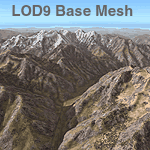
Detailed terrain mesh of the Southeastern Himalayan Ranges, N26-32 E90-98. The files in this package are based on Shuttle Radar (SRTM) Version 2 data but with many of the void areas, especially the most significant sections, filled with elevation data generated from topographic maps by Jonathan de Ferranti. While Jonathan's work is unrelated to flight simulation he kindly gave me permission to compile his data for use in FS. The result is a wonderful improvement in detail and accuracy over any existing mesh file, freeware or commercial, based on SRTM or DTED data alone.
Due to the large area of the Himalayas I've compiled the source data as two separate series: the "Himalayan Peaks" series covers prominent mountains and ranges in higher detail and locally overrides any existing LOD9 terrain mesh. In addition, a LOD9 "base mesh" series, with LOD8 and LOD7 "buffer" mesh files, covering the entire Himalayas, is meant for those who do not yet have an add-on terrain mesh of these beautiful mountains.
| Filename: | Himalayas_LOD9_Base_Mesh_Volume_1__Southeastern_Ra.zip |
| License: | Freeware, limited distribution |
| Added: | 29th May 2010, 09:01:26 |
| Downloads: | 10,298 |
| Author: | Holger Sandmann, Jonathan de Ferranti |
| Size: | 71.82 MB |
| Category: Flight Simulator 2004 - Scenery | |
| Himalayas LOD9 Base Mesh, Volume 4 - Kashmir and Jammu |
|
File Description:
Detailed terrain mesh of the Kashmir and Jammu Ranges, N30-39 E76-78. The files in this package are based on Shuttle Radar (SRTM) Version 2 data but with many of the void areas, especially the most significant sections, filled with elevation data generated from topographic maps by Jonathan de Ferranti. While Jonathan's work is unrelated to flight simulation he kindly gave me permission to compile his data for use in FS. The result is a wonderful improvement in detail and accuracy over any existing mesh file, freeware or commercial, based on SRTM or DTED data alone.
Due to the large area of the Himalayas I've compiled the source data as two separate series: the "Himalayan Peaks" series covers prominent mountains and ranges in higher detail and locally overrides any existing LOD9 terrain mesh. In addition, the LOD9 "base mesh" series, with LOD8 and LOD7 "buffer" mesh files, covering the entire Himalayas, is meant for those who do not yet have an add-on terrain mesh of these beautiful mountains.
| Filename: | Himalayas_LOD9_Base_Mesh_Volume_4__Kashmir_and_Jam.zip |
| License: | Freeware, limited distribution |
| Added: | 22nd February 2006, 20:32:50 |
| Downloads: | 7,503 |
| Author: | Holger Sandmann, Jonathan de Ferranti |
| Size: | 29.24 MB |
© 2001-2026 AVSIM Online
All Rights Reserved
Privacy Policy |