
Where Flight Simulation Enthusiasts Gather from Around the World!
AVSIM Library - Search Results

| Category: Flight Simulator 2004 - Scenery | |
| "Himalayan Peaks" LOD10 Mesh, Volume 4 - Annapurna |

|
Images related to this file:
File Description:

Highly detailed terrain mesh of the Annapurna area, N28-30 E83-85. The files in this package are based on Shuttle Radar (SRTM) Version 2 data but with many of the void areas, especially the most significant sections, filled with elevation data generated from topographic maps by Jonathan de Ferranti. While Jonathan's work is unrelated to flight simulation he kindly gave me permission to compile his data for use in FS. The result is a wonderful improvement in detail and accuracy over any existing mesh file, freeware or commercial, based on SRTM or DTED data alone.
Due to the large area of the Himalayas I've compiled the source data as two separate series: the "Himalayan Peaks" series covers prominent mountains and ranges in higher detail and locally overrides any existing LOD9 terrain mesh. In addition, a LOD9 "base mesh" series covering the entire Himalayas will be available for those who do not yet have an add-on terrain mesh of these beautiful mountains.
| Filename: | fs_him_04.zip |
| License: | Freeware, limited distribution |
| Added: | 29th May 2010, 08:59:29 |
| Downloads: | 10,439 |
| Author: | Holger Sandmann, Jonathan de Ferranti |
| Size: | 15.07 MB |
| Category: Flight Simulator 2004 - Scenery | |
| Namibia, Southwestern Africa Mesh Part 1 Of 5 |
|
File Description:
Add-on mesh for the entire country of Namibia (S17-29 E11-21), including the Caprivi Strip east to the Victoria Falls (Zambia/Zimbabwe). The source data are 3-arcsec (~90-m) Shuttle Radar (SRTM) files, compiled at LOD9 (76-m) resolution. Processing with John Childs' Blackart (v3.74) and Peter Guth's MicroDEM (v7.02). Includes a LOD7 buffer mesh to prevent blue slivers in the mid to far distance. Part 1 of 5.
| Filename: | namib_cp.zip |
| License: | Freeware |
| Added: | 5th April 2004, 00:17:54 |
| Downloads: | 6,365 |
| Author: | Holger Sandmann |
| Size: | 16.03 MB |
| Category: Flight Simulator 2004 - Scenery | |
| Namibia, Southwestern Africa Mesh Part 2 Of 5 |
|
File Description:
Add-on mesh for the entire country of Namibia (S17-29 E11-21), including the Caprivi Strip east to the Victoria Falls (Zambia/Zimbabwe). The source data are 3-arcsec (~90-m) Shuttle Radar (SRTM) files, compiled at LOD9 (76-m) resolution. Processing with John Childs' Blackart (v3.74) and Peter Guth's MicroDEM (v7.02). Includes a LOD7 buffer mesh to prevent blue slivers in the mid to far distance. Part 2 of 5.
| Filename: | namib_ne.zip |
| License: | Freeware, limited distribution |
| Added: | 5th April 2004, 00:18:13 |
| Downloads: | 5,091 |
| Author: | Holger Sandmann |
| Size: | 21.39 MB |
| Category: Fly! II - Development | |
| SRTM to RAS - Tutorial French Version |
|
File Description:
How to import SRTM files into FLY! II (Comment importer des fichiers SRTM dans FLY! II).
| Filename: | srtm2ras-fr.zip |
| License: | Freeware |
| Added: | 1st September 2004, 20:27:29 |
| Downloads: | 111 |
| Author: | Daniele Tona |
| Size: | 908 KB |
| Category: Flight Simulator 2004 - Scenery | |
| Upgrade Project México Real LOD8 |
|
File Description:
Upgrade for the Mexico-U.S.A. bordering area for the mexico_8.zip file, replacing SRTM-1 data with NED data. Part of the "Proyecto México Real" project, compiled at LOD8 (4.96 arcseconds in latitude and 6.6 arcseconds in longitude) resolution from INEGI data. Intended to enhance the virtual flying experience with the more detailed LOD9 and LOD10 versions compiled from the same data. Compatible backwards with Flight Simulator 2000, Flight Simulator 2002 and Combat Flight Simulator 2
| Filename: | mexico_8upg.zip |
| License: | Check within download |
| Added: | 12th January 2006, 06:11:03 |
| Downloads: | 1,934 |
| Author: | Juan José Galván Bautista |
| Size: | 7.39 MB |
| Category: Flight Simulator 2004 - Scenery | |
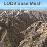
| Himalayas LOD9 Base Mesh, Volume 1 - Southeastern Ranges |
|
Images related to this file:
File Description:

Detailed terrain mesh of the Southeastern Himalayan Ranges, N26-32 E90-98. The files in this package are based on Shuttle Radar (SRTM) Version 2 data but with many of the void areas, especially the most significant sections, filled with elevation data generated from topographic maps by Jonathan de Ferranti. While Jonathan's work is unrelated to flight simulation he kindly gave me permission to compile his data for use in FS. The result is a wonderful improvement in detail and accuracy over any existing mesh file, freeware or commercial, based on SRTM or DTED data alone.
Due to the large area of the Himalayas I've compiled the source data as two separate series: the "Himalayan Peaks" series covers prominent mountains and ranges in higher detail and locally overrides any existing LOD9 terrain mesh. In addition, a LOD9 "base mesh" series, with LOD8 and LOD7 "buffer" mesh files, covering the entire Himalayas, is meant for those who do not yet have an add-on terrain mesh of these beautiful mountains.
| Filename: | fs_him_b1.zip |
| License: | Freeware, limited distribution |
| Added: | 29th May 2010, 09:01:26 |
| Downloads: | 10,270 |
| Author: | Holger Sandmann, Jonathan de Ferranti |
| Size: | 71.82 MB |
| Category: Flight Simulator 2004 - Scenery | |
| Himalayas LOD9 Base Mesh, Volume 2 - Southcentral Ranges |
|
Images related to this file:
File Description:

Detailed terrain mesh of the Southcentral Himalayan Ranges, N26-32 E82-90. The files in this package are based on Shuttle Radar (SRTM) Version 2 data but with many of the void areas, especially the most significant sections, filled with elevation data generated from topographic maps by Jonathan de Ferranti. While Jonathan's work is unrelated to flight simulation he kindly gave me permission to compile his data for use in FS. The result is a wonderful improvement in detail and accuracy over any existing mesh file, freeware or commercial, based on SRTM or DTED data alone.
Due to the large area of the Himalayas I've compiled the source data as two separate series: the "Himalayan Peaks" series covers prominent mountains and ranges in higher detail and locally overrides any existing LOD9 terrain mesh. In addition, a LOD9 "base mesh" series, with LOD8 and LOD7 "buffer" mesh files, covering the entire Himalayas, is meant for those who do not yet have an add-on terrain mesh of these beautiful mountains.
| Filename: | fs_him_b2.zip |
| License: | Freeware, limited distribution |
| Added: | 29th May 2010, 09:05:56 |
| Downloads: | 9,424 |
| Author: | Holger Sandmann, Jonathan de Ferranti |
| Size: | 90.25 MB |
| Category: Flight Simulator 2004 - Scenery | |
| Himalayas LOD9 Base Mesh, Volume 3 - Southwestern Ranges |
|
Images related to this file:
File Description:
Detailed terrain mesh of the Southwestern Himalayan Ranges, N28-37 E78-82. The files in this package are based on Shuttle Radar (SRTM) Version 2 data but with many of the void areas, especially the most significant sections, filled with elevation data generated from topographic maps by Jonathan de Ferranti. While Jonathan's work is unrelated to flight simulation he kindly gave me permission to compile his data for use in FS. The result is a wonderful improvement in detail and accuracy over any existing mesh file, freeware or commercial, based on SRTM or DTED data alone.
Due to the large area of the Himalayas I've compiled the source data as two separate series: the "Himalayan Peaks" series covers prominent mountains and ranges in higher detail and locally overrides any existing LOD9 terrain mesh. In addition, the LOD9 "base mesh" series, with LOD8 and LOD7 "buffer" mesh files, covering the entire Himalayas, is meant for those who do not yet have an add-on terrain mesh of these beautiful mountains.
| Filename: | fs_him_b3.zip |
| License: | Freeware, limited distribution |
| Added: | 30th May 2010, 10:00:26 |
| Downloads: | 155,792 |
| Author: | Holger Sandmann, Jonathan de Ferranti |
| Size: | 62.16 MB |
| Category: Flight Simulator 2004 - Scenery | |
| "Himalayan Peaks" LOD10 Mesh, Volume 8 - Tirich Mir and Pamir |
|
Images related to this file:
File Description:
Highly detailed terrain mesh of the Tirich Mir and Pamir areas, N36-39 E71-74. The files in this package are based on Shuttle Radar (SRTM) Version 2 data but with many of the void areas, especially the most significant sections, filled with elevation data generated from topographic maps by Jonathan de Ferranti. While Jonathan's work is unrelated to flight simulation he kindly gave me permission to compile his data for use in FS. The result is a wonderful improvement in detail and accuracy over any existing mesh file, freeware or commercial, based on SRTM or DTED data alone.
Due to the large area of the Himalayas I've compiled the source data as two separate series: the "Himalayan Peaks" series covers prominent mountains and ranges in higher detail and locally overrides any existing LOD9 terrain mesh. In addition, a LOD9 "base mesh" series covering the entire Himalayas will be available for those who do not yet have an add-on terrain mesh of these beautiful mountains.
| Filename: | fs_him_08.zip |
| License: | Freeware, limited distribution |
| Added: | 29th May 2010, 08:52:47 |
| Downloads: | 9,082 |
| Author: | Holger Sandmann, Jonathan de Ferranti |
| Size: | 47.94 MB |
| Category: Flight Simulator 2004 - Scenery | |
| Himalayas LOD9 Base Mesh, Volume 4 - Kashmir and Jammu |
|
File Description:
Detailed terrain mesh of the Kashmir and Jammu Ranges, N30-39 E76-78. The files in this package are based on Shuttle Radar (SRTM) Version 2 data but with many of the void areas, especially the most significant sections, filled with elevation data generated from topographic maps by Jonathan de Ferranti. While Jonathan's work is unrelated to flight simulation he kindly gave me permission to compile his data for use in FS. The result is a wonderful improvement in detail and accuracy over any existing mesh file, freeware or commercial, based on SRTM or DTED data alone.
Due to the large area of the Himalayas I've compiled the source data as two separate series: the "Himalayan Peaks" series covers prominent mountains and ranges in higher detail and locally overrides any existing LOD9 terrain mesh. In addition, the LOD9 "base mesh" series, with LOD8 and LOD7 "buffer" mesh files, covering the entire Himalayas, is meant for those who do not yet have an add-on terrain mesh of these beautiful mountains.
| Filename: | fs_him_b4.zip |
| License: | Freeware, limited distribution |
| Added: | 22nd February 2006, 20:32:50 |
| Downloads: | 7,489 |
| Author: | Holger Sandmann, Jonathan de Ferranti |
| Size: | 29.24 MB |
© 2001-2025 AVSIM Online
All Rights Reserved