
Where Flight Simulation Enthusiasts Gather from Around the World!
AVSIM Library - Search Results

| Category: Flight Simulator 2004 - Scenery | |
| Northsee Intl |

|
File Description:
This airport.
EHNZ This airport is a special edition from AADG Europe.
This airport is build on water On the Noordzee.
It's verey exclusive.
Please enjoy.
The light's are beautifal...
| Filename: | northsee_intl_ehnz.zip |
| License: | Freeware, limited distribution |
| Added: | 22nd June 2004, 20:39:50 |
| Downloads: | 420 |
| Author: | AADG Europe |
| Size: | 5 KB |
| Category: Flight Simulator 2004 - Scenery | |
| EHNZ Northsee Intl |
|
File Description:
This airport EHNZ.
This airport is a special edition.
From AADG Europe.
It's build on water.
It's verey cool.
The light are verey beautifal.
Enjoy...
| Filename: | northsee_intl_ehnz_(fixed).zip |
| License: | Freeware, limited distribution |
| Added: | 22nd June 2004, 20:57:10 |
| Downloads: | 615 |
| Author: | AADG Europe |
| Size: | 5 KB |
| Category: Flight Simulator 2004 - Scenery | |
| Rotterdam Zestienhoven Airport (EHRD) |
|
File Description:
This is EHRD Rotterdam Airport.
Airport has 2 closed grass runway's
One of those runway is gone.
And one is made active again.
And made asphalt and longer with ILS and better runway light. This file requires Afcad 2.11 or higher.
If you don't have that.
No problem.
goto: http://groups.msn.com/aadgeurope.
And goto the Airport Download/Tools and there you can download Afcad 2.21....
Enjoy...
| Filename: | ehrd_rotterdam_zestienhoven.zip |
| License: | Freeware, limited distribution |
| Added: | 23rd June 2004, 19:36:31 |
| Downloads: | 1,965 |
| Author: | AADG Europe |
| Size: | 3 KB |
| Category: Flight Simulator 2004 - Scenery | |
| Tehran area SRTM mesh |
|
File Description:
This terrain mesh scenery is centered on Tehran city. Ranging from 34.1°N to 37.5°N and 49.2°E to 54.8°E, it includes Elbourz moutain range as well as Caspian sea shores (28 meters below sea lavel).
Based on SRTM Data (3 arcsec, 90m) and sampled to LOD9 resolution (76m) using Matthew Styles's program "SRTM To BGL v1.04". While only tested with Fs2004, this mesh should also run with FS2002.
SRTM 3 arcsec dataset has numerous and sometimes huge void areas. But thanks to John Child's beautiful and powerful "Blackart" utility it's now easy to patch these areas with lower resolution dataset: I took the coupled interpolation method to merge SRTM 3-arcsec with SRTM 30-arcsec dataset when needed. This gives the best results, as patched areas with 30-arcsec data are blending naturally with surrounding 3-arcsec mesh. Of course the resolution of patched areas is quite poor, but still a bit better than the default LOD5 mesh. However, in exception of Demavend Peak, the SRTM data was quite good for this area and didn't need much patching so that the rendering is allways excellent.
| Filename: | tehran_srtm.zip |
| License: | Freeware, limited distribution |
| Added: | 20th June 2004, 14:14:31 |
| Downloads: | 5,561 |
| Author: | Yohann Baptiste |
| Size: | 18.09 MB |
| Category: Flight Simulator 2004 - Scenery | |
| Northern Oman SRTM mesh |
|
File Description:
This terrain mesh scenery covers northern of Oman emirate as well as some parts of United Arab Emirates (Dubai, Sharjah, Ras Al Khaima, Fujiarah...). The southern and western boundaries are approx 22°N / 54°E.
No part of Iran has been included.
Based on SRTM Data (3 arcsec, 90m) and sampled to LOD9 resolution (76m) using Matthew Styles's program "SRTM To BGL v1.04". While only tested with Fs2004, this mesh should also run with FS2002.
SRTM 3 arcsec dataset has numerous void areas in this part of the world. But thanks to John Child's beautiful and powerful "Blackart" utility it's now easy to patch these areas with lower resolution dataset: I took the coupled interpolation method to merge SRTM 3-arcsec with SRTM 30-arcsec dataset when needed. This gives the best results, as patched areas with 30-arcsec data are blending naturally with surrounding 3-arcsec mesh. Of course the resolution of patched areas is quite poor, but still a bit better than the default LOD5 mesh.
| Filename: | n_oman_srtm.zip |
| License: | Freeware, limited distribution |
| Added: | 20th June 2004, 14:11:59 |
| Downloads: | 8,195 |
| Author: | Yohann Baptiste |
| Size: | 16.44 MB |
| Category: Flight Simulator 2004 - Scenery | |
| "Himalayan Peaks" LOD10 Mesh, Volume 6 - Jammu and Kashmir |
|
Images related to this file:
File Description:
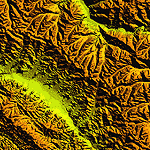
Highly detailed terrain mesh of the Jammu and Kashmir areas, N31-36 E76-78. The files in this package are based on Shuttle Radar (SRTM) Version 2 data but with many of the void areas, especially the most significant sections, filled with elevation data generated from topographic maps by Jonathan de Ferranti. While Jonathan's work is unrelated to flight simulation he kindly gave me permission to compile his data for use in FS. The result is a wonderful improvement in detail and accuracy over any existing mesh file, freeware or commercial, based on SRTM or DTED data alone.
Due to the large area of the Himalayas I've compiled the source data as two separate series: the "Himalayan Peaks" series covers prominent mountains and ranges in higher detail and locally overrides any existing LOD9 terrain mesh. In addition, a LOD9 "base mesh" series covering the entire Himalayas will be available for those who do not yet have an add-on terrain mesh of these beautiful mountains.
| Filename: | fs_him_06.zip |
| License: | Freeware, limited distribution |
| Added: | 29th May 2010, 08:55:43 |
| Downloads: | 9,632 |
| Author: | Holger Sandmann, Jonathan de Ferranti |
| Size: | 52.19 MB |
| Category: Flight Simulator 2004 - Scenery | |
| "Himalayan Peaks" LOD10 Mesh, Volume 7 - K2 and Karakoram |
|
Images related to this file:
File Description:
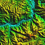
Highly detailed terrain mesh of the Karakoram area, N35-37 E73-77. The files in this package are based on Shuttle Radar (SRTM) Version 2 data but with many of the void areas, especially the most significant sections, filled with elevation data generated from topographic maps by Jonathan de Ferranti. While Jonathan's work is unrelated to flight simulation he kindly gave me permission to compile his data for use in FS. The result is a wonderful improvement in detail and accuracy over any existing mesh file, freeware or commercial, based on SRTM or DTED data alone.
Due to the large area of the Himalayas I've compiled the source data as two separate series: the "Himalayan Peaks" series covers prominent mountains and ranges in higher detail and locally overrides any existing LOD9 terrain mesh. In addition, a LOD9 "base mesh" series covering the entire Himalayas will be available for those who do not yet have an add-on terrain mesh of these beautiful mountains.
| Filename: | fs_him_07.zip |
| License: | Freeware, limited distribution |
| Added: | 30th May 2010, 09:56:27 |
| Downloads: | 9,448 |
| Author: | Holger Sandmann, Jonathan de Ferranti |
| Size: | 38.58 MB |
| Category: Flight Simulator 2004 - Scenery | |
| "Himalayan Peaks" LOD10 Mesh, Volume 3 - Namcha Barwa |
|
File Description:
Highly detailed terrain mesh of the Namcha Barwa area, N29°-31° E94°-96°. The files in this package are based on Shuttle Radar (SRTM) Version 2 data but with many of the void areas, especially the most significant sections, filled with elevation data generated from topographic maps by Jonathan de Ferranti. While Jonathan's work is unrelated to flight simulation he kindly gave me permission to compile his data for use in FS. The result is a wonderful improvement in detail and accuracy over any existing mesh file, freeware or commercial, based on SRTM or DTED data alone. Due to the large area of the Himalayas I've compiled the source data as two separate series: the "Himalayan Peaks" series covers prominent mountains and ranges in higher detail and locally overrides any existing LOD9 terrain mesh. In addition, a LOD9 "base mesh" series covering the entire Himalayas will be available for those who do not yet have an add-on terrain mesh of these beautiful mountains.
| Filename: | fs_him_03.zip |
| License: | Freeware, limited distribution |
| Added: | 18th February 2006, 23:15:17 |
| Downloads: | 12,162 |
| Author: | Holger Sandmann and Jonathan de Ferranti |
| Size: | 15.09 MB |
| Category: Flight Simulator 2004 - Scenery | |
| "Himalayan Peaks" LOD10 Mesh, Volume 5 - Garhwal |
|
File Description:
Highly detailed terrain mesh of the Garhwal area, N30°-32° E78°-81°. The files in this package are based on Shuttle Radar (SRTM) Version 2 data but with many of the void areas, especially the most significant sections, filled with elevation data generated from topographic maps by Jonathan de Ferranti. While Jonathan's work is unrelated to flight simulation he kindly gave me permission to compile his data for use in FS. The result is a wonderful improvement in detail and accuracy over any existing mesh file, freeware or commercial, based on SRTM or DTED data alone. Due to the large area of the Himalayas I've compiled the source data as two separate series: the "Himalayan Peaks" series covers prominent mountains and ranges in higher detail and locally overrides any existing LOD9 terrain mesh. In addition, a LOD9 "base mesh" series covering the entire Himalayas will be available for those who do not yet have an add-on terrain mesh of these beautiful mountains.
| Filename: | fs_him_05.zip |
| License: | Freeware, limited distribution |
| Added: | 18th February 2006, 23:16:47 |
| Downloads: | 10,105 |
| Author: | Holger Sandmann and Jonathan de Ferranti |
| Size: | 27.72 MB |
| Category: Flight Simulator 2004 - Scenery | |
| Himalayan Peaks LOD10 Mesh, Volume 1 - Mt. Everest and Kula Kangri |
|
File Description:
Highly detailed terrain mesh of the Mt. Everest and Kula Kangri areas, N26°-29° E85°-92°. The files in this package are based on Shuttle Radar (SRTM) Version 2 data but with many of the void areas, especially the most significant sections, filled with elevation data generated from topographic maps by Jonathan de Ferranti. While Jonathan's work is unrelated to flight simulation he kindly gave me permission to compile his data for use in FS. The result is a wonderful improvement in detail and accuracy over any existing mesh file, freeware or commercial, based on SRTM or DTED data alone. Due to the large area of the Himalayas I've compiled the source data as two separate series: the "Himalayan Peaks" series covers prominent mountains and ranges in higher detail and locally overrides any existing LOD9 terrain mesh. In addition, a LOD9 "base mesh" series covering the entire Himalayas will be available for those who do not yet have an add-on terrain mesh of these beautiful mountains.
| Filename: | fs_him_01.zip |
| License: | Freeware, limited distribution |
| Added: | 9th February 2006, 22:13:00 |
| Downloads: | 37,006 |
| Author: | Holger Sandmann and Jonathan de Ferranti |
| Size: | 52.01 MB |
© 2001-2025 AVSIM Online
All Rights Reserved