
Where Flight Simulation Enthusiasts Gather from Around the World!
AVSIM Library - Search Results

| Category: Prepar3D V1-4 - Scenery | |
| Canne della Battaglia Puglia Barletta Italy N41.17.81 E16.09.08 |

|
Images related to this file:
File Description:
Canne della Battaglia Puglia Barletta Italy N41.17.81 E16.09.08. This scenario rappresents Canne an ancient city of Puglia, which stood at 54 m s.l.m. above a hill located on the right bank of the Ofanto, 9 km from the sea. Famous for the famous Battle of Canne, today in the locality called Canne della Battaglia. Like many Apulian cities, Canne was born between the VI-IV century BC Here on August 2, 216 BC, perhaps in the locality still known today as the field of blood, the famous "Battle of Canne" took place, where the Romans suffered a serious defeat by the Carthaginians led by Hannibal. Later, a battle between the Byzantines and the Longobardi was also fought here. Today famous archaeological site and important point of report VFR.
| Filename: | Canne_della_Battaglia_Puglia_Barletta_Italy__N4117.zip |
| License: | Freeware |
| Added: | 12th December 2017, 23:20:40 |
| Downloads: | 167 |
| Author: | Pasquale Marrulli |
| Size: | 4.5 KB |
| Category: Prepar3D V1-4 - Scenery | |
| Marino Lighthouse South Australia |
|
File Description:
Marino Lighthouse
This lighthouse is a well known VFR reference and reporting point just outside the Adelaide TMA.
It installs quite happily in FSX, P3D v3.4 and P3Dv4 in the usual fashion.
It was crafted in Sketchup8, it was converted to a .bgl in Model Converter X _ http://www.scenerydesign.org/modelconverterx/ - (A HUGE shoutout to Arno Gerretsen). The ground textures and excludes were done in Luis Sa's SBuilderX - http://www.ptsim.com/index.php?option=com_content&view=article&id=52&Itemid=56 .
In the Marino Lighthouse Extras sub-directory I "show my work". Please mess about with it should you feel so inclined.
The usual caveats concerning the use of these files in pursuit of profit or monetary gain apply. Contravention thereof will earn you a scathing reprimand.
Quig
18/04/17
| Filename: | Marino_Lighthouse_South_Australia.zip |
| License: | Freeware |
| Added: | 25th June 2017, 07:25:14 |
| Downloads: | 133 |
| Author: | Richard Quigley |
| Size: | 3.66 MB |
| Category: Flight Simulator 2004 - Scenery | |
| Even More Private Strips |
|
File Description:
Even more 'Private Strips' from around England and Wales. When combined with my previous "Private Strips Revisited" upload these will give a total of nearly 500 little airfields, which have been predominantly created to provide a source for GA and microlight ai traffic flights, without having to clutter up the more major airfields. All airfields have parking for (usually) two aircraft and associated taxiways to facilitate their coming and going.
Please note :- these sceneries have been designed for use in FS2004 with the original UK VFR Photographic scenery and mesh. They rely for details on the "usual" collections of library objects, specifically EZ-Scenery, UKVFR and Rwy12 libraries. Whilst other configurations will probably work, to a degree, you'll have to try them and see if they suit you. See the enclosed ReadMe for further details.
| Filename: | Even_More_Private_Strips.zip |
| License: | Freeware |
| Added: | 3rd August 2021, 00:59:25 |
| Downloads: | 139 |
| Author: | Chris Eve |
| Size: | 495.15 KB |
| Category: Flight Simulator X - Flight Plans | |
| Current Low Altitude Military Training Route in the Northeastern United States |
|
Images related to this file:
File Description:
FSX Flight Plans for current low altitude military training route in the Northeastern U.S. This package includes 196 individual flight plans for IFR, VFR and Slow Speed Routes. These are great routes for B-52, F-111, B-1B, B-2 A6, A4, Vulcan and any fighter or bomber enthusiasts. Of course you can fly the route with any aircraft of your choice. Also included in this package are two spectacular gauges by Karol Chlebowski for TFR flying and Pave Tack which includes many advanced features for bombing, navigation and reconnaissance. These two gauges will greatly enhance your ability to fly these challenging routes and are a great companion of the flight plans. Another option is to download Version 2.1 of my mini panel which has all this functionality and more.
| Filename: | Current_Low_Altitude_Military_Training_Route_in_th.zip |
| License: | Freeware |
| Added: | 15th September 2011, 14:02:30 |
| Downloads: | 418 |
| Author: | Bill McClellan |
| Size: | 7.18 MB |
| Category: Flight Simulator X - Flight Plans | |
| Current Low Altitude Military Training Route in the South Central United States |
|
Images related to this file:
File Description:
FSX Flight Plans for current low altitude military training route in the South Central U.S. This package includes 179 individual flight plans for IFR, VFR and Slow Speed Routes. These are great routes for B-52, F-111, B-1B, B-2 A6, A4, Vulcan and any fighter or bomber enthusiasts. Of course you can fly the route with any aircraft of your choice. Also included in this package are two spectacular gauges by Karol Chlebowski for TFR flying and Pave Tack which includes many advanced features for bombing, navigation and reconnaissance. These two gauges will greatly enhance your ability to fly these challenging routes and are a great companion of the flight plans. Another option is to download Version 2.1 of my mini panel which has all this functionality and more.
| Filename: | Current_Low_Altitude_Military_Training_Route_in_th.zip |
| License: | Freeware |
| Added: | 16th September 2011, 14:13:54 |
| Downloads: | 342 |
| Author: | Bill McClellan |
| Size: | 4.74 MB |
| Category: Flight Simulator X - Flight Plans | |
| Current Low Altitude Military Training Route in the North Central United States |
|
Images related to this file:
File Description:
FSX Flight Plans for current low altitude military training route in the North Central U.S. This package includes 77 individual flight plans for IFR, VFR and Slow Speed Routes. These are great routes for B-52, F-111, B-1B, B-2 A6, A4, Vulcan and any fighter or bomber enthusiasts. Of course you can fly the route with any aircraft of your choice. Also included in this package are two spectacular gauges by Karol Chlebowski for TFR flying and Pave Tack which includes many advanced features for bombing, navigation and reconnaissance. These two gauges will greatly enhance your ability to fly these challenging routes and are a great companion of the flight plans. Another option is to download Version 2.1 of my mini panel which has all this functionality and more.
| Filename: | Current_Low_Altitude_Military_Training_Route_in_th.zip |
| License: | Freeware |
| Added: | 16th September 2011, 14:14:26 |
| Downloads: | 388 |
| Author: | Bill McClellan |
| Size: | 5.13 MB |
| Category: Flight Simulator X - Flight Plans | |
| Current Low Altitude Military Training Route in the Southwesternl United States |
|
Images related to this file:
File Description:
FSX Flight Plans for current low altitude military training route in the Southwestern U.S. This package includes 142 individual flight plans for IFR, VFR and Slow Speed Routes. These are great routes for B-52, F-111, B-1B, B-2 A6, A4, Vulcan and any fighter or bomber enthusiasts. Of course you can fly the route with any aircraft of your choice. Also included in this package are two spectacular gauges by Karol Chlebowski for TFR flying and Pave Tack which includes many advanced features for bombing, navigation and reconnaissance. These two gauges will greatly enhance your ability to fly these challenging routes and are a great companion of the flight plans. Another option
is to download Version 2.1 of my mini panel which has all this functionality and more.
| Filename: | Current_Low_Altitude_Military_Training_Route_in_th.zip |
| License: | Freeware |
| Added: | 16th September 2011, 14:14:58 |
| Downloads: | 382 |
| Author: | Bill McClellan |
| Size: | 7.03 MB |
| Category: Flight Simulator X - Flight Plans | |
| Current Low Altitude Military Training Route in the Northhwestern United States |
|
Images related to this file:
File Description:
FSX Flight Plans for current low altitude military training route in the Northwestern U.S. This package includes 75 individual flight plans for IFR, VFR and Slow Speed Routes. These are great routes for B-52, F-111, B-1B, B-2 A6, A4, Vulcan and any fighter or bomber enthusiasts. Of course you can fly the route with any aircraft of your choice. Also included in this package are two spectacular gauges by Karol Chlebowski for TFR flying and Pave Tack which includes many advanced features for bombing, navigation and reconnaissance. These two gauges will greatly enhance
your ability to fly these challenging routes and are a great companion of the flight plans. Another option is to download Version 2.1 of my mini panel which has all this functionality and more.
| Filename: | Current_Low_Altitude_Military_Training_Route_in_th.zip |
| License: | Freeware |
| Added: | 16th September 2011, 14:15:22 |
| Downloads: | 426 |
| Author: | Bill McClellan |
| Size: | 5.37 MB |
| Category: Flight Simulator X - Flight Plans | |
| Current Low Altitude Military Training Route in Alaska |
|
Images related to this file:
File Description:
FSX Flight Plans for current low altitude military training route in Alaska. This package includes 53 individual flight plans for IFR, VFR and Slow Speed Routes. These are great routes for B-52, F-111, B-1B, B-2 A6, A4, Vulcan and any fighter or bomber enthusiasts. Of course you can fly the route with any aircraft of your choice. Also included in this package are two spectacular gauges by Karol Chlebowski for TFR flying and Pave Tack which includes many advanced features for bombing, navigation and reconnaissance. These two gauges will greatly enhance your ability to fly these challenging routes and are a great companion of the flight plans. Another option is to download Version 2.1 of my mini panel which has all this functionality and more.
| Filename: | Current_Low_Altitude_Military_Training_Route_in_Al.zip |
| License: | Freeware |
| Added: | 16th September 2011, 14:15:58 |
| Downloads: | 566 |
| Author: | Bill McClellan |
| Size: | 1.71 MB |
| Category: Flight Simulator 2004 - Scenery | |
| Perrine Bridge, Twin Falls Idaho Updated |
|
Images related to this file:
File Description:
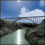
A prominent VFR landmark near Twin Falls Idaho, the Perrine Bridge spans over 1600' and stands 486 feet above the river below. At one time it was the tallest bridge in the world. Perrine Bridge is the only man-made structure in the USA were "base jumping" is allowed without a permit 365 days out of the year. Download includes gmax bridge object, a small photoscenery for the surrounding area, and two saved flight scenarios for exploring the scenery in the default J3 Cub. Bridge surface is landable and crash box has been removed allowing flight beneath the bridge. Scenery is compatible with, and nicely compliments John B. Loney's "Joslin-Magic Valley Regl" airport scenery (ktwf_v1.zip). Requires Ultimate Terrain and freeware mesh product, links provided in the readme.
| Filename: | Perrine_Bridge_Twin_Falls_Idaho_Updated.zip |
| License: | Freeware, limited distribution |
| Added: | 5th July 2011, 04:28:11 |
| Downloads: | 411 |
| Author: | Jim Robinson |
| Size: | 1.52 MB |


© 2001-2026 AVSIM Online
All Rights Reserved
Privacy Policy |