
Where Flight Simulation Enthusiasts Gather from Around the World!
AVSIM Library - Search Results

| Category: Flight Simulator 2004 - Scenery | |
| "Himalayan Peaks" LOD10 Mesh, Volume 3 - Namcha Barwa |

|
File Description:
Highly detailed terrain mesh of the Namcha Barwa area, N29°-31° E94°-96°. The files in this package are based on Shuttle Radar (SRTM) Version 2 data but with many of the void areas, especially the most significant sections, filled with elevation data generated from topographic maps by Jonathan de Ferranti. While Jonathan's work is unrelated to flight simulation he kindly gave me permission to compile his data for use in FS. The result is a wonderful improvement in detail and accuracy over any existing mesh file, freeware or commercial, based on SRTM or DTED data alone. Due to the large area of the Himalayas I've compiled the source data as two separate series: the "Himalayan Peaks" series covers prominent mountains and ranges in higher detail and locally overrides any existing LOD9 terrain mesh. In addition, a LOD9 "base mesh" series covering the entire Himalayas will be available for those who do not yet have an add-on terrain mesh of these beautiful mountains.
| Filename: | Himalayan_Peaks_LOD10_Mesh_Volume_3__Namcha_Barwa.zip |
| License: | Freeware, limited distribution |
| Added: | 18th February 2006, 23:15:17 |
| Downloads: | 12,188 |
| Author: | Holger Sandmann and Jonathan de Ferranti |
| Size: | 15.09 MB |
| Category: Flight Simulator 2004 - Scenery | |
| "Himalayan Peaks" LOD10 Mesh, Volume 5 - Garhwal |
|
File Description:
Highly detailed terrain mesh of the Garhwal area, N30°-32° E78°-81°. The files in this package are based on Shuttle Radar (SRTM) Version 2 data but with many of the void areas, especially the most significant sections, filled with elevation data generated from topographic maps by Jonathan de Ferranti. While Jonathan's work is unrelated to flight simulation he kindly gave me permission to compile his data for use in FS. The result is a wonderful improvement in detail and accuracy over any existing mesh file, freeware or commercial, based on SRTM or DTED data alone. Due to the large area of the Himalayas I've compiled the source data as two separate series: the "Himalayan Peaks" series covers prominent mountains and ranges in higher detail and locally overrides any existing LOD9 terrain mesh. In addition, a LOD9 "base mesh" series covering the entire Himalayas will be available for those who do not yet have an add-on terrain mesh of these beautiful mountains.
| Filename: | Himalayan_Peaks_LOD10_Mesh_Volume_5__Garhwal.zip |
| License: | Freeware, limited distribution |
| Added: | 18th February 2006, 23:16:47 |
| Downloads: | 10,134 |
| Author: | Holger Sandmann and Jonathan de Ferranti |
| Size: | 27.72 MB |
| Category: Flight Simulator 2004 - Scenery | |
| "Himalayan Peaks" LOD10 Mesh, Volume 6 - Jammu and Kashmir |
|
Images related to this file:
File Description:
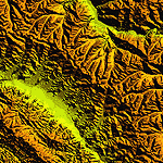
Highly detailed terrain mesh of the Jammu and Kashmir areas, N31-36 E76-78. The files in this package are based on Shuttle Radar (SRTM) Version 2 data but with many of the void areas, especially the most significant sections, filled with elevation data generated from topographic maps by Jonathan de Ferranti. While Jonathan's work is unrelated to flight simulation he kindly gave me permission to compile his data for use in FS. The result is a wonderful improvement in detail and accuracy over any existing mesh file, freeware or commercial, based on SRTM or DTED data alone.
Due to the large area of the Himalayas I've compiled the source data as two separate series: the "Himalayan Peaks" series covers prominent mountains and ranges in higher detail and locally overrides any existing LOD9 terrain mesh. In addition, a LOD9 "base mesh" series covering the entire Himalayas will be available for those who do not yet have an add-on terrain mesh of these beautiful mountains.
| Filename: | Himalayan_Peaks_LOD10_Mesh_Volume_6__Jammu_and_Kas.zip |
| License: | Freeware, limited distribution |
| Added: | 29th May 2010, 08:55:43 |
| Downloads: | 9,666 |
| Author: | Holger Sandmann, Jonathan de Ferranti |
| Size: | 52.19 MB |
| Category: Flight Simulator 2004 - Scenery | |
| "Himalayan Peaks" LOD10 Mesh, Volume 7 - K2 and Karakoram |
|
Images related to this file:
File Description:

Highly detailed terrain mesh of the Karakoram area, N35-37 E73-77. The files in this package are based on Shuttle Radar (SRTM) Version 2 data but with many of the void areas, especially the most significant sections, filled with elevation data generated from topographic maps by Jonathan de Ferranti. While Jonathan's work is unrelated to flight simulation he kindly gave me permission to compile his data for use in FS. The result is a wonderful improvement in detail and accuracy over any existing mesh file, freeware or commercial, based on SRTM or DTED data alone.
Due to the large area of the Himalayas I've compiled the source data as two separate series: the "Himalayan Peaks" series covers prominent mountains and ranges in higher detail and locally overrides any existing LOD9 terrain mesh. In addition, a LOD9 "base mesh" series covering the entire Himalayas will be available for those who do not yet have an add-on terrain mesh of these beautiful mountains.
| Filename: | Himalayan_Peaks_LOD10_Mesh_Volume_7__K2_and_Karako.zip |
| License: | Freeware, limited distribution |
| Added: | 30th May 2010, 09:56:27 |
| Downloads: | 9,480 |
| Author: | Holger Sandmann, Jonathan de Ferranti |
| Size: | 38.58 MB |
| Category: Flight Simulator 2004 - Scenery | |
| Himalayan Peaks LOD10 Mesh, Volume 1 - Mt. Everest and Kula Kangri |
|
File Description:
Highly detailed terrain mesh of the Mt. Everest and Kula Kangri areas, N26°-29° E85°-92°. The files in this package are based on Shuttle Radar (SRTM) Version 2 data but with many of the void areas, especially the most significant sections, filled with elevation data generated from topographic maps by Jonathan de Ferranti. While Jonathan's work is unrelated to flight simulation he kindly gave me permission to compile his data for use in FS. The result is a wonderful improvement in detail and accuracy over any existing mesh file, freeware or commercial, based on SRTM or DTED data alone. Due to the large area of the Himalayas I've compiled the source data as two separate series: the "Himalayan Peaks" series covers prominent mountains and ranges in higher detail and locally overrides any existing LOD9 terrain mesh. In addition, a LOD9 "base mesh" series covering the entire Himalayas will be available for those who do not yet have an add-on terrain mesh of these beautiful mountains.
| Filename: | Himalayan_Peaks_LOD10_Mesh_Volume_1__Mt_Everest_an.zip |
| License: | Freeware, limited distribution |
| Added: | 9th February 2006, 22:13:00 |
| Downloads: | 37,047 |
| Author: | Holger Sandmann and Jonathan de Ferranti |
| Size: | 52.01 MB |
| Category: Flight Simulator X - Miscellaneous Files | |
| Quality Wings 787 - Additional maps for EGYPT |
|
Images related to this file:
File Description:
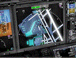
This package included 11 airport for egypt displayed on Qualitywings 787 Navigation Display ND. Airports is
Cairo (HECA) sharm el sheikh(HESH) hurghada(HEGN) marsa alam(HEMA) borg el arab(HEBA) Aswan(HESN) Luxor(HELX) alamein(HEAL) Asyut(HEAT) arish(HEAR) marsa matrouh(HEMM)
| Filename: | Quality_Wings_787__Additional_maps_for_EGYPT.zip |
| License: | Freeware |
| Added: | 19th October 2017, 17:03:02 |
| Downloads: | 839 |
| Author: | Mohamed Fawzi |
| Size: | 411.58 KB |
| Category: Flight Simulator 2004 - AI Aircraft | |
| World of AI Midwest Airlines [Egypt] Complete AI Package |
|
Images related to this file:
File Description:

World of AI welcomes you to this Midwest Airlines [Egypt] Complete AI Package for FS2004 and FSX. Models by AI Aardvark; Repaints by Billy Rutherford; Representative flightplans by Billy Rutherford. IMPORTANT! You need the World of AI Installer to make this package work! (WOAINS24.zip).
| Filename: | World_of_AI_Midwest_Airlines_Egypt_Complete_AI_Pac.zip |
| License: | Freeware, limited distribution |
| Added: | 4th March 2011, 14:58:19 |
| Downloads: | 29,587 |
| Author: | World of AI |
| Size: | 737.54 KB |
| Category: Flight Simulator 2004 - AI Aircraft | |
| MD-82 WindRose OP |
|
File Description:
Repaint of the WindRose MD-82 for AI Aardvark. Aircraft is operated by Khors Aircompany based in Kyiv and is flying holiday and ad hoc charters this summer. Included are MRAI fictitious flightplans featuring an eclectic mix of flights between Ukraine and Turkey/Egypt.
| Filename: | MD82_WindRose_OP.zip |
| License: | Freeware, limited distribution |
| Added: | 15th July 2007, 22:40:27 |
| Downloads: | 1,145 |
| Author: | Paul w. Irving |
| Size: | 238.44 KB |
| Category: Flight Simulator 2004 - Aircraft Repaints, Textures and Modifications | |
| EgyptAir Cargo Airbus A300-600 |
|
File Description:
This is a repaint of Egypt Air Cargo on the Commercial Level Simulation A300-600 GE engine model, registration SU-BOG "TOSHKI". I have modified the night textures to match the aircraft cargo configuration. You must have the CLS model for the texture to work.
| Filename: | EgyptAir_Cargo_Airbus_A300600.zip |
| License: | Freeware |
| Added: | 1st April 2006, 22:36:28 |
| Downloads: | 1,273 |
| Author: | Mohammed Al-Khalifa / CLS |
| Size: | 4.32 MB |
| Category: Prepar3D V5 - AI Aircraft | |
| ZAS Airlines of Egypt Boeing 707-320 |
|
Images related to this file:
File Description:
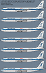
ZAS Airlines of Egypt Boeing 707-320 for retro AI traffic, with seven variants utlizing the NAAI 707-320 model set. This package is for FSX/P3D only with DDS DXT5 textures. Aircraft model and master paint kit by NAAI, repaints by Michael Pearson.
| Filename: | ZAS_Airlines_of_Egypt_Boeing_707320.zip |
| License: | Freeware |
| Added: | 3rd September 2021, 05:05:46 |
| Downloads: | 89 |
| Author: | Michael Pearson |
| Size: | 1.64 MB |


© 2001-2026 AVSIM Online
All Rights Reserved
Privacy Policy |