
Where Flight Simulation Enthusiasts Gather from Around the World!
AVSIM Library - Search Results

| Category: Prepar3D V5 - Scenery | |
| HECA Cairo Intl Airport - Cairo, Egypt |

|
File Description:
This scenery is a major modification/update of HECA Cairo Intl Airport for P3Dv5. The airport is now more up-to-date and realistic. Please refer to the Readme file for more details.
| Filename: | HECA_Cairo_Intl_Airport__Cairo_Egypt.zip |
| License: | Freeware |
| Added: | 23rd December 2022, 21:38:07 |
| Downloads: | 758 |
| Author: | David Midgett |
| Size: | 830.54 KB |
| Category: Flight Simulator 2004 - AI Flight Plans | |
| Thomas Cook Airlines Belgium Winter 13-14 |
|
Images related to this file:
File Description:

Thomas Cook operate a small fleet of A319/320 aircraft from their Brussels hub to holiday resorts in the Canary islands, Egypt, Morocco, Cabo verde and more. Its own fleet is implemented by a Condor aircraft during week-ends.
| Filename: | Thomas_Cook_Airlines_Belgium_Winter_1314.zip |
| License: | Freeware |
| Added: | 12th January 2014, 19:18:11 |
| Downloads: | 407 |
| Author: | Dimitri Tousmanof |
| Size: | 27.28 KB |
| Category: Flight Simulator 2004 - Aircraft Repaints, Textures and Modifications | |
| Thomas Cook Airlines 'Egypt, where it all begins' Airbus A321-211 (G-TCDA) |
|
Images related to this file:
File Description:

New repaint for the Project Airbus A321-200,this time comes with Thomas Cook Airlines 'Egypt, where it all begins' special livery.Repaint of a real aircraft registered as G-TCDA. Project Airbus A321 model included. Also compatible with FSX
| Filename: | Thomas_Cook_Airlines_Egypt_where_it_all_begins_Air.zip |
| License: | Freeware, limited distribution |
| Added: | 21st September 2012, 00:15:21 |
| Downloads: | 1,294 |
| Author: | Xudeva Irribarra / Project Airbus |
| Size: | 11.23 MB |
| Category: Flight Simulator 2004 - AFCAD Files | |
| El Kharga - New Valley Airport, Egypt (HEKG) |
|
File Description:
FS2004 Afcad2 file to replace the default HEKG at El Kharga, Egypt. Just the addition of a few more gates, including medium gates and a cargo area with two ramps. Someone out there may wish to use it. www.matva.org.uk
| Filename: | El_Kharga__New_Valley_Airport_Egypt_HEKG.zip |
| License: | Freeware |
| Added: | 29th November 2004, 14:16:17 |
| Downloads: | 688 |
| Author: | Louie Maclennan, MATVA |
| Size: | 2.31 KB |
| Category: Flight Simulator X - Scenery | |
| Millau Viaduct Bridge Patch |
|
File Description:
Patch for scenery Millau Viaduct Bridge.
In order to obtain a better adaptation of the viaduct with the ground, this archive contains three choices, according to the installed add-ons in your Scenery library:
options-1 Without UTX Europe and with Mesh France of France VFR. Option-2 With UTX Europe without Mesh France of France VFR.
Option-3 Without UTX Europe and Without Mesh France of France VFR.
The scenery " millau_Viaduct_FSX.zip " is needed. Download on AVSIM File Library.
| Filename: | Millau_Viaduct_Bridge_Patch.zip |
| License: | Freeware, limited distribution |
| Added: | 31st March 2008, 17:54:03 |
| Downloads: | 4,337 |
| Author: | Jean-Claude Irle |
| Size: | 11.23 KB |
| Category: Flight Simulator 2004 - Scenery | |
| Himalayas LOD9 Base Mesh, Volume 1 - Southeastern Ranges |
|
Images related to this file:
File Description:
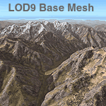
Detailed terrain mesh of the Southeastern Himalayan Ranges, N26-32 E90-98. The files in this package are based on Shuttle Radar (SRTM) Version 2 data but with many of the void areas, especially the most significant sections, filled with elevation data generated from topographic maps by Jonathan de Ferranti. While Jonathan's work is unrelated to flight simulation he kindly gave me permission to compile his data for use in FS. The result is a wonderful improvement in detail and accuracy over any existing mesh file, freeware or commercial, based on SRTM or DTED data alone.
Due to the large area of the Himalayas I've compiled the source data as two separate series: the "Himalayan Peaks" series covers prominent mountains and ranges in higher detail and locally overrides any existing LOD9 terrain mesh. In addition, a LOD9 "base mesh" series, with LOD8 and LOD7 "buffer" mesh files, covering the entire Himalayas, is meant for those who do not yet have an add-on terrain mesh of these beautiful mountains.
| Filename: | Himalayas_LOD9_Base_Mesh_Volume_1__Southeastern_Ra.zip |
| License: | Freeware, limited distribution |
| Added: | 29th May 2010, 09:01:26 |
| Downloads: | 10,298 |
| Author: | Holger Sandmann, Jonathan de Ferranti |
| Size: | 71.82 MB |
| Category: Flight Simulator 2004 - Scenery | |
| Himalayas LOD9 Base Mesh, Volume 2 - Southcentral Ranges |
|
Images related to this file:
File Description:

Detailed terrain mesh of the Southcentral Himalayan Ranges, N26-32 E82-90. The files in this package are based on Shuttle Radar (SRTM) Version 2 data but with many of the void areas, especially the most significant sections, filled with elevation data generated from topographic maps by Jonathan de Ferranti. While Jonathan's work is unrelated to flight simulation he kindly gave me permission to compile his data for use in FS. The result is a wonderful improvement in detail and accuracy over any existing mesh file, freeware or commercial, based on SRTM or DTED data alone.
Due to the large area of the Himalayas I've compiled the source data as two separate series: the "Himalayan Peaks" series covers prominent mountains and ranges in higher detail and locally overrides any existing LOD9 terrain mesh. In addition, a LOD9 "base mesh" series, with LOD8 and LOD7 "buffer" mesh files, covering the entire Himalayas, is meant for those who do not yet have an add-on terrain mesh of these beautiful mountains.
| Filename: | Himalayas_LOD9_Base_Mesh_Volume_2__Southcentral_Ra.zip |
| License: | Freeware, limited distribution |
| Added: | 29th May 2010, 09:05:56 |
| Downloads: | 9,447 |
| Author: | Holger Sandmann, Jonathan de Ferranti |
| Size: | 90.25 MB |
| Category: Flight Simulator 2004 - Scenery | |
| Himalayas LOD9 Base Mesh, Volume 4 - Kashmir and Jammu |
|
File Description:
Detailed terrain mesh of the Kashmir and Jammu Ranges, N30-39 E76-78. The files in this package are based on Shuttle Radar (SRTM) Version 2 data but with many of the void areas, especially the most significant sections, filled with elevation data generated from topographic maps by Jonathan de Ferranti. While Jonathan's work is unrelated to flight simulation he kindly gave me permission to compile his data for use in FS. The result is a wonderful improvement in detail and accuracy over any existing mesh file, freeware or commercial, based on SRTM or DTED data alone.
Due to the large area of the Himalayas I've compiled the source data as two separate series: the "Himalayan Peaks" series covers prominent mountains and ranges in higher detail and locally overrides any existing LOD9 terrain mesh. In addition, the LOD9 "base mesh" series, with LOD8 and LOD7 "buffer" mesh files, covering the entire Himalayas, is meant for those who do not yet have an add-on terrain mesh of these beautiful mountains.
| Filename: | Himalayas_LOD9_Base_Mesh_Volume_4__Kashmir_and_Jam.zip |
| License: | Freeware, limited distribution |
| Added: | 22nd February 2006, 20:32:50 |
| Downloads: | 7,503 |
| Author: | Holger Sandmann, Jonathan de Ferranti |
| Size: | 29.24 MB |
| Category: Flight Simulator 2004 - Scenery | |
| Himalayas LOD9 Base Mesh, Volume 3 - Southwestern Ranges |
|
Images related to this file:
File Description:

Detailed terrain mesh of the Southwestern Himalayan Ranges, N28-37 E78-82. The files in this package are based on Shuttle Radar (SRTM) Version 2 data but with many of the void areas, especially the most significant sections, filled with elevation data generated from topographic maps by Jonathan de Ferranti. While Jonathan's work is unrelated to flight simulation he kindly gave me permission to compile his data for use in FS. The result is a wonderful improvement in detail and accuracy over any existing mesh file, freeware or commercial, based on SRTM or DTED data alone.
Due to the large area of the Himalayas I've compiled the source data as two separate series: the "Himalayan Peaks" series covers prominent mountains and ranges in higher detail and locally overrides any existing LOD9 terrain mesh. In addition, the LOD9 "base mesh" series, with LOD8 and LOD7 "buffer" mesh files, covering the entire Himalayas, is meant for those who do not yet have an add-on terrain mesh of these beautiful mountains.
| Filename: | Himalayas_LOD9_Base_Mesh_Volume_3__Southwestern_Ra.zip |
| License: | Freeware, limited distribution |
| Added: | 30th May 2010, 10:00:26 |
| Downloads: | 155,808 |
| Author: | Holger Sandmann, Jonathan de Ferranti |
| Size: | 62.16 MB |
| Category: Flight Simulator 2004 - Scenery | |
| Himalayas LOD9 Base Mesh, Volume 5 - Hindu Kush and Pamir |
|
Images related to this file:
File Description:

Detailed terrain mesh of the Hindu Kush and Pamir Ranges, N32-40 E70-76. The files in this package are based on Shuttle Radar (SRTM) Version 2 data but with many of the void areas, especially the most significant sections, filled with elevation data generated from topographic maps by Jonathan de Ferranti. While Jonathan's work is unrelated to flight simulation he kindly gave me permission to compile his data for use in FS. The result is a wonderful improvement in detail and accuracy over any existing mesh file, freeware or commercial, based on SRTM or DTED data alone.
Due to the large area of the Himalayas I've compiled the source data as two separate series: the "Himalayan Peaks" series covers prominent mountains and ranges in higher detail and locally overrides any existing LOD9 terrain mesh. In addition, the LOD9 "base mesh" series, with LOD8 and LOD7 "buffer" mesh files, covering the entire Himalayas, is meant for those who do not yet have an add-on terrain mesh of these beautiful mountains.
| Filename: | Himalayas_LOD9_Base_Mesh_Volume_5__Hindu_Kush_and_.zip |
| License: | Freeware, limited distribution |
| Added: | 29th May 2010, 08:57:29 |
| Downloads: | 7,603 |
| Author: | Holger Sandmann, Jonathan de Ferranti |
| Size: | 85.72 MB |
© 2001-2026 AVSIM Online
All Rights Reserved
Privacy Policy |