
Where Flight Simulation Enthusiasts Gather from Around the World!
AVSIM Library - Search Results

| Category: Flight Simulator 2004 - Scenery | |
| LOD10 (38-m) Glacier Bay National Park, Alaska |

|
File Description:
This LOD10 (38-m) add-on mesh of Glacier Bay National Park and the adjacent Lynn Canal area between Juneau and Skagway (N58-60 W134-138) is an optional (!) upgrade of gl_bay_1.zip (by Holger Sandmann and Jim Keir). It adds more detail to the mountainous areas and allows to locally override other installed Alaska add-on meshes without having to deactivate them. The USGS NED seamless digital elevation data used for this mesh have a 2-arcsec (~60-m) resolution. Thus, the compilation as LOD10 (38-m) will reveal all terrain details contained in the source data. Please read the gl_bay_1.zip read-me file for further information about the special features of the Glacier Bay Project.
| Filename: | LOD10_38m_Glacier_Bay_National_Park_Alaska.zip |
| License: | Freeware, limited distribution |
| Added: | 16th February 2004, 03:40:57 |
| Downloads: | 8,593 |
| Author: | Holger Sandmann |
| Size: | 24.98 MB |
| Category: Flight Simulator 2004 - AI Flight Plans | |
| Libyan Airlines - Summer 2009 |
|
File Description:
Flightplans for Libyan Airlines, based on the week of Apr 20 to Apr 26, 2009. Out of Benghazi and Tripoli, Libyan Airlines is operating scheduled services to Beida, Ghadames, Ghat, Houn, Kufra, Misratah, Sebha and Sirte (Libya), Algiers (Algeria), Amman (Jordan), Athens (Greece), Cairo and Alexandria (Egypt), Casablanca (Morocco), Damascus (Syria), Dubai (UAE), Istanbul (Turkey), Jeddah (Saudi Arabia), Kiev (Ukraine), London and Manchester (UK), Luqa (Malta), Milan and Rome (Italy) as well as Tunis (Tunisia). All published flights are included. Enjoy!
| Filename: | Libyan_Airlines__Summer_2009.zip |
| License: | Freeware |
| Added: | 28th April 2009, 09:47:26 |
| Downloads: | 764 |
| Author: | Christian Hegewald |
| Size: | 10.81 KB |
| Category: Flight Simulator 2004 - Flight Plans | |
| Flightplan Mombasa (HKMO) - Vienna (LOWW) for Level-D Sim 767 |
|
File Description:
Here is a flightplan for the Level-D Sim 767 from Mombasa (HKMO) to Vienna (LOWW). The flightplan is based on a route which I found at http://www.vacc-sag.org, so I think it is real as possible. The flight time can be up to eight hours, so it is a nice long houl flight, which takes you over Kenia, Ethiopia, Sudan, Egypt and than via Greece and the Balkan to Vienna. I recommend the Lauda Air 767 for this flight.
| Filename: | Flightplan_Mombasa_HKMO__Vienna_LOWW_for_LevelD_Si.zip |
| License: | Freeware |
| Added: | 13th March 2005, 02:51:48 |
| Downloads: | 736 |
| Author: | Peter Andrew Marten |
| Size: | 2.64 KB |
| Category: Flight Simulator 2004 - AI Flight Plans | |
| Sudan Airways - Summer 2009 |
|
File Description:
Flightplans for Sudan Airways, based on the week of Apr 20 to Apr 26, 2009. Out of Khartoum, Sudan Airways is operating scheduled services to Al Fashir, Dongola, El Obeid, Juba, Malakal, Nyala, Port Sudan and Wadi Halfa (Sudan), Abu Dhabi and Dubai (UAE), Addis Ababa (Ethiopia), Amman (Jordan), Cairo (Egypt), Damascus (Syria), Doha (Qatar), Entebbe (Uganda), Jeddah and Riyadh (Saudi Arabia), Kano (Nigeria), London (UK), N'Djamena (Chad), Nairobi (Kenya) as well as Tripoli (Libya). All published flights are included. Enjoy!
| Filename: | Sudan_Airways__Summer_2009.zip |
| License: | Freeware |
| Added: | 28th April 2009, 09:45:18 |
| Downloads: | 754 |
| Author: | Christian Hegewald |
| Size: | 7.76 KB |
| Category: Flight Simulator 2004 - AI Flight Plans | |
| Thomsonfly Winter 2007/08 (v2) |
|
File Description:
Thomsonfly flightplans for the week of December 17th-23rd 2007. Taken from an independent source, these plans are 100% correct down to each and every positioning flight. Featuring all ski flights to the Alps, christmas charters to Lapland and cruise charters to Barbados, as well as flights to the traditional bucket and spade destinations in the Caribbean, Spain, Portugal, Egypt, Tunisia, and low cost destinations such as Jersey and Prague. See readme for more information. This second release fixes a minor timing issue.
| Filename: | Thomsonfly_Winter_200708_v2.zip |
| License: | Freeware, limited distribution |
| Added: | 22nd December 2007, 04:11:08 |
| Downloads: | 1,129 |
| Author: | Stephen Wiseman |
| Size: | 13.52 KB |
| Category: Flight Simulator 2004 - Scenery | |
| Joshua Tree + San Bernardino Mountains, California 38m Terrain Mesh |
|
File Description:
USGS SRTM30 1 arc-second, resampled to LOD10 (38.2 meters). This terrain mesh is centered at Joshua Tree National Park in southern California. Coverage area: From West 115.1° to West 117.4° and North 33.7° to North 34.3°. It includes the National Park, the Palm Springs area with Mount San Jacinto and the San Bernardino Mountains.
| Filename: | Joshua_Tree__San_Bernardino_Mountains_California_3.zip |
| License: | Freeware, limited distribution |
| Added: | 4th January 2004, 21:05:58 |
| Downloads: | 3,714 |
| Author: | Andreas Trawny |
| Size: | 4.57 MB |
| Category: Flight Simulator 2004 - Scenery | |
| Guadalupe Mountains National Park (Version 2) SRTM30_1ArcSec Terrain Mesh |
|
File Description:
This 38m terrain mesh is centered in the 'Panhandle' region of Western Texas.
Coverage area: From West 104.5° to West 105° and North 31.7° to North 32.2°.
It includes Guadalupe Mountains National Park and the surrounding mountains
of Lincoln National Forest. Version 2 replaces my former release of 'Guadalupe_Mountains_SRTM30.zip' which covered a too large area and had some scenery anomalies (craters). The new version now fixes these errors.
| Filename: | Guadalupe_Mountains_National_Park_Version_2_SRTM30.zip |
| License: | Freeware, limited distribution |
| Added: | 28th December 2003, 18:33:52 |
| Downloads: | 2,062 |
| Author: | Andreas Trawny |
| Size: | 1.27 MB |
| Category: Flight Simulator X - Scenery | |
| California Central Coast with Megascenery Earth and FSGenesis Mesh |
|
Images related to this file:
File Description:
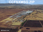
California Central Coast Scenery for FSX with Megascenery Earth and FSGenesis mesh. CCFSXMSG.ZIP covers the California coastal region from N36° 10' (Coalinga) to N34° 25' (Santa Barbara) and from the coast East to W119° 40'. It is a version of my previously created California Central Coast scenery redesigned and expanded to work with FSX MegaScenery Earth and FSGenesis USA Terrain Mesh for FSX V2 by Justin Tyme. Airstrips in the area covered by this scenery have been added for a total of 27 airports and airstrips. 6 imaginary water runways are also added for AI float plane traffic. Several other areas of interest such as the Santa Barbara marina, Morro Bay, etc. are included for a total of 41 points of interest. All airports, airstrips and related structures have been adjusted and realigned to conform to actual positions and dimensions as indicated by the MegaScenery Earth satellite textures. Megascenery Earth California-13, -14 and -15 are required and -12, -28 and -29 are recommended. By Al Wheeler 9/25/09.
| Filename: | California_Central_Coast_with_Megascenery_Earth_an.zip |
| License: | Freeware |
| Added: | 7th January 2010, 19:54:57 |
| Downloads: | 870 |
| Author: | Al Wheeler |
| Size: | 8.13 MB |
| Category: Flight Simulator 2004 - Scenery | |
| Azores Islands, North Atlantic Ocean 76m SRTM Terrain Mesh |
|
File Description:
USGS SRTM 3 arc-second, resampled to LOD9 (76 meters). This is a terrain mesh scenery of the Azores Islands in the North Atlantic Ocean. It includes the following islands: Flores, Corvo, Faial, Pico with 7,711 feet (2,351m) high Pico Volcano, Sao Jorge, Graciosa, Terceira, Sao Miguel and Santa Maria.
| Filename: | Azores_Islands_North_Atlantic_Ocean_76m_SRTM_Terra.zip |
| License: | Freeware, limited distribution |
| Added: | 8th April 2004, 03:20:23 |
| Downloads: | 7,983 |
| Author: | Andreas Trawny |
| Size: | 1.81 MB |
| Category: Flight Simulator 2004 - Scenery | |
| Backcountry USFS fields for 19m terrain mesh in Idaho |
|
Images related to this file:
File Description:
These backcountry airfields are for use with the FSGenesis 19m mesh of Idaho; they almost certainly do not work without it. I also have Ultimate Terrain installed, with the settings as noted. The 15 airfields included here are almost all United States Forestry Service fields: 1U1 Moose Creek, 2ID7 Cayuse Creek, 2U5 Shearer, 3U1 Warren, 12ID Flying B Ranch, 24K Krassel, 75c Orogrande, I08 Cabin Creek, ID67 Lower Loon Creek, ID76 Wilson Bar, S81 Indian Creek, S92 Fish Lake, U54 Bernard, U79 Chamberlain, U81 Cold Meadows. There is also a 85U bgl included to remove the remnants of Soldier Bar which is impossible to make into a scenery with the terrain mesh, and spoiled the surroundings if left untouched and intact. The screenshots are typical examples giving a good impression of the terrain.
| Filename: | Backcountry_USFS_fields_for_19m_terrain_mesh_in_Id.zip |
| License: | Freeware, limited distribution |
| Added: | 22nd July 2019, 16:38:48 |
| Downloads: | 100 |
| Author: | Roger Wensley |
| Size: | 22.2 MB |
© 2001-2026 AVSIM Online
All Rights Reserved
Privacy Policy |