
Where Flight Simulation Enthusiasts Gather from Around the World!
AVSIM Library - Search Results

| Category: Flight Simulator 2004 - Scenery | |
| KGIF Winter Haven and KVDF Tampa Executive Airports |

|
Images related to this file:
File Description:
This Zip package contains two FS9 airports created using ADE9X. The two airports are Winter Haven's Gilbert and Tampa Executive. I used photo data from Google Maps to make the files. To install simply unzip the files into the FS9 Addon Scenery Scenery folder.
Here is a list of the scenery objects used in these files. If you don't have any of these on your system, they will not appear. They are all freeware and available at at AVSIM and Flightsim.com:
ga hangars ss v.3
ga hangars ss vol 2 v1
DB Parkinglots
ez-terminals ss
large hangars ss V2
loney's hangars and buildings
Loney's Hangars and Buildings2
loney's buildings
ez-extra-objects-1
warehouse airport vehicles
| Filename: | KGIF_Winter_Haven_and_KVDF_Tampa_Executive_Airport.zip |
| License: | Freeware |
| Added: | 31st July 2013, 19:08:11 |
| Downloads: | 252 |
| Author: | Michael Verlin |
| Size: | 112.6 KB |
| Category: Flight Simulator X - Aircraft Repaints, Textures and Modifications | |
| Horizon Air Bombardier Q400 (WSU and UI fix) |
|
File Description:
These are the night texture fixes for the Horizon WSU and University of Idaho paint schemes I uploaded earlier this month. I noticed the night textures were wrong and this will fix the issue. Thank you for downloading and enjoying my repaints.
| Filename: | Horizon_Air_Bombardier_Q400_WSU_and_UI_fix.zip |
| License: | Freeware |
| Added: | 13th May 2013, 14:23:48 |
| Downloads: | 1,516 |
| Author: | Kevin Jessee |
| Size: | 2.07 MB |
| Category: Flight Simulator X - Aircraft Repaints, Textures and Modifications | |
| TUIfly "Air One and Two" Boeing 737-700 |
|
Images related to this file:
File Description:
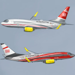
TUIfly DB Air One And DB Air Two texture set for the TDS Boeing 737-700 (not included, must download base package). Model developed by Tenkuu Developers Studio, features high resolution textures, dynamic flexing wings, nose gear steering, rudder lock, ground spoilers, low speed aileron locks at high speed, fully animated control surfaces, fully independent suspension, trim animation, opening passenger doors, rolling wheels, animated thrust reversers with reverser block doors, detailed textures, full night lighting, ground service vehicles and more. Model design by Hiroshi Igami. Flight dynamics design by Nick Wilkinson, with assistance from David Biggar. Master textures and paint kit by Kyle Schurb. Painted on the great TDS model by Triadi Sudarmawan.
| Filename: | TUIfly_Air_One_and_Two_Boeing_737700.zip |
| License: | Freeware |
| Added: | 4th October 2013, 21:56:05 |
| Downloads: | 389 |
| Author: | Triadi Sudarmawan |
| Size: | 3.72 MB |
| Category: Flight Simulator X - Aircraft Repaints, Textures and Modifications | |
| HLX and XL Airways Germany Boeing 737-800 |
|
Images related to this file:
File Description:
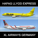
HAPAG LLOYD EXPRESS (HLX) AND XL AIRWAYS GERMANY B737-800 texture set for the TDS Boeing 737-800 and Boeing 737-700 (not included, must download base package). Model developed by Tenkuu Developers Studio, features high resolution textures, dynamic flexing wings, nose gear steering, rudder lock, ground spoilers, low speed aileron locks at high speed, fully animated control surfaces, fully independent suspension, trim animation, opening passenger doors, rolling wheels, animated thrust reversers with reverser block doors, detailed textures, full night lighting, ground service vehicles and more. Model design by Hiroshi Igami. Flight dynamics design by Nick Wilkinson, with assistance from David Biggar. Master textures and paint kit by Kyle Schurb. Painted by Triadi Sudarmawan for the great TDS model. Also works with FS2004.
| Filename: | HLX_and_XL_Airways_Germany_Boeing_737800.zip |
| License: | Freeware |
| Added: | 5th April 2014, 17:02:41 |
| Downloads: | 292 |
| Author: | Triadi "ACHONK" Sudarmawan |
| Size: | 8.57 MB |
| Category: Flight Simulator X - Panels | |
| Panel Builder 2.8 Trial for FSX and FS2004 |
|
Images related to this file:
File Description:

Time limited trial of simPlugins Panel Builder 2.8 for FSX (Simconnect) and FS2004 (FSUIPC). Creating a custom instrument panel could not be easier. Unlimited panel can be made for up to 4 engine aircraft including turbines and helicopters This version features support for touch screens. You can simply touch a radio knob with your finger and with a circular motion, set the frequency, how neat is that? This 10 minute trial is limited to 6 instruments out of over 112. Existing users can upgrade to Panel Builder 2.8 for Free and prospective buyers and cockpit builders can try before they buy. Not compatible with Windows XP, requires .NET4 Extended.
| Filename: | Panel_Builder_28_Trial_for_FSX_and_FS2004.zip |
| License: | Commercial demo |
| Added: | 28th January 2014, 13:48:45 |
| Downloads: | 659 |
| Author: | reinhard Hussell |
| Size: | 14.41 MB |
| Category: Flight Simulator X - Panels | |
| Panel Builder EFIS 2.8 for FSX and FS2004 |
|
Images related to this file:
File Description:

Time limited trial of simPlugins Panel Builder 2.8 EFIS for Microsoft FSX (Simconnect) and FS2004 (FSUIPC). Creating a custom instrument panel could not be easier. This version features support for touch screens plus has an aileron trim gauge. You can simply touch a radio knob with your finger and with a circular motion, set the frequency, how neat is that? This 10 minute trial is limited to 6 instruments out of around 60. Existing users can upgrade to 2.8 for free and prospective buyers and cockpit builders can try before they buy. Not compatible with Windows XP, requires .NET4 Extended.
| Filename: | Panel_Builder_EFIS_28_for_FSX_and_FS2004.zip |
| License: | Commercial demo |
| Added: | 28th January 2014, 13:53:24 |
| Downloads: | 168 |
| Author: | Reinhard Hussell |
| Size: | 17.16 MB |
| Category: Flight Simulator X - Scenery | |
| East Mesa and Phoenix Sky Harbor Airport Updates |
|
File Description:
KSDL:
Added ILS and Terminal with Jetways and Corrected Gate Numbers
KFFZ:
Added ILS and a small gate (NO JETWAY)
KCHD:
Added ILS
KPHX:
ADDED ILS TO 25R (DO NOT INSTALL UNLESS WANTED)
There are 4 airport updates in this package. I added ILS to all the regional and municipal airports in MESA, AZ that don't have ILS (most CAT III).
| Filename: | East_Mesa_and_Phoenix_Sky_Harbor_Airport_Updates.zip |
| License: | Freeware |
| Added: | 2nd December 2013, 05:30:00 |
| Downloads: | 359 |
| Author: | Alex Kulak |
| Size: | 73.12 KB |
| Category: Flight Simulator X - Scenery | |
| Improved and/or New terrains around Dijon, France |
|
Images related to this file:
File Description:
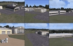
That FSX freeware is adding or improving terrains around Dijon, France, with Beaune-Challanges (LFGF), Dijon-Darois (LFGI), Nuits-Saint-Georges-La Berchere (LFGZ), Pouilly-en-Auxois-Maconge (LFEP), and Til-Chatel (LFET).**NOTE: A better and easier choice is to install the latest, stand-alone 3.0 version, at "dijonnais_terrains_3.0.zip"!
| Filename: | Improved_andor_New_terrains_around_Dijon_France.zip |
| License: | Freeware |
| Added: | 16th July 2014, 16:37:20 |
| Downloads: | 290 |
| Author: | Gerard Guichard |
| Size: | 272.13 KB |
| Category: Flight Simulator 2004 - AI Flight Plans | |
| ASL Air Services Ltd. Guyana - Flightplans and Repaint |
|
File Description:
FS2004 Flightplans and Repaint for ASL Air Services Ltd. Guyana.
| Filename: | ASL_Air_Services_Ltd_Guyana__Flightplans_and_Repai.zip |
| License: | Freeware |
| Added: | 31st August 2014, 12:13:08 |
| Downloads: | 320 |
| Author: | Lutz Fischer |
| Size: | 572.79 KB |
| Category: Flight Simulator X - Utilities | |
| AI Monitoring and Taxi Speed Controller for Prepar3D |
|
File Description: This application allows you to monitor and more importantly set the taxi
speed of AI aircraft in Prepar3d.
Increasing the taxi speed, from the default of 20 knots, allows the aircraft to
vacant the runway sooner. Thereby reducing the induced go-arounds. As the
"runway" taxi speed is bled off automatically while the aircraft is still on the
runway, the Runway Taxi Speed should be set quite high, 60-80 is a reasonable
setting, but can even be set higher.
This has only been tested against Prepar3d v2.2,
however it should work with earlier versions of
Prepar3d.
| Filename: | AI_Monitoring_and_Taxi_Speed_Controller_for_Prepar.zip |
| License: | Freeware |
| Added: | 10th August 2014, 23:49:51 |
| Downloads: | 937 |
| Author: | Joe Oliveira |
| Size: | 698.96 KB |


© 2001-2026 AVSIM Online
All Rights Reserved
Privacy Policy |