
Where Flight Simulation Enthusiasts Gather from Around the World!
AVSIM Library - Search Results

| Category: Flight Simulator 2004 - Aircraft Repaints, Textures and Modifications | |
| USA 3000 Airbus A320 |

|
File Description:
A USA 3000 repaint for the Simmer's Sky (SMS) / Overland Airbus A320. Repaint features almost brand new base textures, new windows, newly-sized overwing exits which I feel are much more accurate than the default's, custom night textures and main textures that were painted to represent the real thing with as much realism as possible. Paint appears to be almost life-like but is completely handpainted with the exception of the windows which are partly photoreal. Textures are in 32-bit for high quality. You must have the Overland A320 to use these textures.
| Filename: | USA_3000_Airbus_A320.zip |
| License: | Freeware, limited distribution |
| Added: | 30th June 2006, 06:19:36 |
| Downloads: | 853 |
| Author: | Kyle Schurb | Simmer's Sky (Overland) |
| Size: | 4.2 MB |
| Category: Flight Simulator X - Aircraft Repaints, Textures and Modifications | |
| Air China "Star Alliance" Airbus A330-243 (B-6091) |
|
Images related to this file:
File Description:
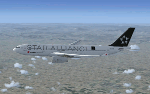
This is a repaint for the freeware Thomas Ruth Airbus A330-200 in the livery of Air China 'B-6091' 'Star Alliance'. B-6091 was delivered to Air China in October 2007. Air China is currently operating 25 Airbus A330-243.
Features: reworked paintkit with photoreal windows and night textures, new bump map textures.
Additional: reworked aircraft.cfg for Thomas Ruth A330-200 for better flying performance.
This file contains TEXTURES ONLY, so you have to install Thomas Ruth's original A330-200 (RR) Aircraft.
| Filename: | Air_China_Star_Alliance_Airbus_A330243_B6091.zip |
| License: | Freeware, limited distribution |
| Added: | 27th January 2013, 19:08:10 |
| Downloads: | 600 |
| Author: | Dominik Stahel |
| Size: | 6.65 MB |
| Category: Flight Simulator X - Scenery | |
| Imam Khomeini Intl. Airport 2015 (v1.0) |
|
Images related to this file:
File Description:
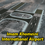
Imam Khomeini International Airport (IATA: IKA, ICAO: OIIE) is the main international airport of Iran, located 30 kilometers (19 mi) southwest of the city of Tehran, near the localities of Robat-Karim and Eslamshahr, on a 13,500-hectare (135 km2) site.
It was designed to replace Mehrabad International Airport, which is in the west of the city, now inside the city boundaries.
The airport was originally designated as Ahmadabad but was later renamed to "Imam Khomeini International Airport".
This package contains "Imam Khomeini International Airport" photoreal scenery based on VE satellites images with LOD19 quality.
| Filename: | Imam_Khomeini_Intl_Airport_2015_v10.zip |
| License: | Freeware, limited distribution |
| Added: | 28th June 2015, 23:54:13 |
| Downloads: | 6,980 |
| Author: | Khashayar Talebzadeh |
| Size: | 227.18 MB |
| Category: Flight Simulator X - AFCAD Files | |
| 19TE - Cut and Shoot Airport, Conroe, Texas. |
|
File Description:
This is a redesign of 19TE - Cut and Shoot Airport, Conroe, Texas. Google Maps and Skyvector has been used to provide the correct (as physically possible within FSX and ADE) position, size and type of runway. The immediate surrounding scenery has been included. ADE used to compile the design.
| Filename: | 19TE__Cut_and_Shoot_Airport_Conroe_Texas.zip |
| License: | Freeware |
| Added: | 21st March 2018, 03:07:52 |
| Downloads: | 160 |
| Author: | Matthew Ward |
| Size: | 592.44 KB |
| Category: Prepar3D V1-4 - Aircraft Repaints, Textures and Modifications | |
| Cessna C310 (G-BODY and G-SOUL) |
|
Images related to this file:
File Description:
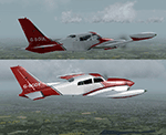
Really, BODY & SOUL. Two C310Rs owned by Oil Spill Response Limited (OSRL)There are tiny differences apart from the registrations. Textures only for Milviz's C310R REDUX. I say again REDUX! Try to get it into the old model will result in an awful mess. Don't come crying to me!
| Filename: | Cessna_C310_GBODY_and_GSOUL.zip |
| License: | Freeware |
| Added: | 22nd March 2018, 23:51:01 |
| Downloads: | 238 |
| Author: | Ron Attwood |
| Size: | 23.87 MB |
| Category: Flight Simulator 2004 - Panels | |
| Golovin N93 and Solomon AK26 in Alaska |
|
Images related to this file:
File Description:
Golovin is a coastal fishing village 70 miles east of Nome and around 20 miles west of Elim, with a population of under 200. The village is a check point on the Iditarod race and the name originates from a Russian admiral in the far distant past. The airfield has a gravel runway which is over 4,000 feet long; the older runway amid the village housing is still visible but not usable. The majority of flights to and from the airfield originate in Nome, but there are also others to and from nearby fields such as Elim, Unalakleet, Shaktoolik, and Koyuk. The AI includes a daily ERA flight. Most flights to villages of this size are in fact not "scheduled", but are "air taxi" being used by three or four villagers to go supermarket shopping in a larger neighbouring town, which in this case is Nome. In many cases the numbers of flights to and from a village in a year average out to one a day. There is a further scenery included here, which is Solomon AK26. Solomon is around 40 miles west of Golovin and from 1898 was suppporting a gold mining operation on the Fish and Niukluk rivers further inland at Council. Solomon, and the airfield which obviously came later, gradually faded from use in competition with Nome, leaving almost nothing behind at Solomon by the 1980's except a gravel runway and the nearby Solomon roadhouse. There are other buildings near the airfield which appear to be new and in good condition, but their function is unknown to me. The Solomon terrain modifications and grass deletion bgl's did not function until loaded in a "Top" folder; this is unusual, and may be required only in my FS9 setup or in all situations. I have no way of knowing as I can only design for my situation. A note here about my scenery making. This is post number 503 and there will not be many more to follow this as I am almost at the end of the photos I either took or found for scenery purposes. There is a limit to what can be located online and I have already been making use of the little there is; eg Unalakleet. Post 520 is unlikely. So, if you are near an airport (preferably Canadian or Alaskan) and have a camera..... Let me know.
| Filename: | Golovin_N93_and_Solomon_AK26_in_Alaska.zip |
| License: | Freeware, limited distribution |
| Added: | 5th August 2019, 16:19:07 |
| Downloads: | 83 |
| Author: | Roger Wensley |
| Size: | 4.23 MB |
| Category: Microsoft Flight Simulator (2020) - Original Aircraft | |
| MSFS MCE FBW Neo Flows and Checklists |
|
Images related to this file:
File Description:
Multi Crew Experience Vox Script flows and checklists for the FBW Neo in MSFS
| Filename: | MSFS_MCE_FBW_Neo_Flows_and_Checklists.zip |
| License: | Freeware |
| Added: | 7th May 2021, 22:41:44 |
| Downloads: | 334 |
| Author: | David Herky |
| Size: | 106.84 MB |
| Category: Prepar3D V1-4 - Gauges | |
| C-27 Loadmaster Panel and Voicepack V1.0 |
|
Images related to this file:
File Description:
This is a panel and voice pack to simulate roughly the tasks of a loadmaster at the IRIS Battlefield Airlifter.
You get a female copilot voice - if You want with different language (australian, italian, british or US) accents.
Additional announcements by copilot to support you flying the aircraft (flap positions, gear up / down and more).
Also new loadmaster voices and announcements are implemented so that airdrops are at least acoustic simulated.
It also delivers a P3D default GPS based Autodrop function.
The panel does not simulate airdrops visually!
For that you would need another addon!
The panel is not compatible with other aircraft mods.
The panel may work with other P3D or even FSX versions but it is not tested.
| Filename: | C27_Loadmaster_Panel_and_Voicepack_V10.zip |
| License: | Freeware |
| Added: | 24th January 2021, 20:34:30 |
| Downloads: | 87 |
| Author: | Alex Jorda |
| Size: | 13.71 MB |
| Category: Prepar3D V1-4 - AI Aircraft | |
| J-Air Embraer ERJ 170 and 190 |
|
Images related to this file:
File Description:
Textures only for AIA EMB 170 and 190. Model and paintkit by AIA. Converted model for P3D by AIG can be found at http://www.alpha-india.net. Painted by Joel Branchu for real traffic with all registrations.
| Filename: | JAir_Embraer_ERJ_170_and_190.zip |
| License: | Freeware |
| Added: | 14th March 2018, 15:26:21 |
| Downloads: | 342 |
| Author: | Joel Branchu |
| Size: | 1.33 MB |
| Category: Prepar3D V1-4 - Scenery | |
| GSX Level 2 and more for UKBB |
|
File Description:
UKBB SODE jetways for P3D V2/3/4. SafeDock, New afcad and more! Instructions and required files are included. Enjoy it and feel free to ask question and to give me feedback! [email protected]
| Filename: | GSX_Level_2_and_more_for_UKBB.zip |
| License: | Freeware |
| Added: | 7th December 2018, 00:31:24 |
| Downloads: | 544 |
| Author: | Eyal Rokach |
| Size: | 270.96 KB |


© 2001-2026 AVSIM Online
All Rights Reserved
Privacy Policy |