
Where Flight Simulation Enthusiasts Gather from Around the World!
AVSIM Library - Search Results

| Category: Prepar3D V1-4 - Scenery | |
| KILE, Killeen Texas airport |

|
Images related to this file:
File Description: Instructions: There are 3 folders in this package; effects, scenery and texture.
Create a subfolder under the C:\Program Files (x86)\Lockheed Martin\Prepar3D v3\Scenery folder and call this new folder KILE.
Place the scenery and texture folders (with their associated contents) under this newly created KILE subfolder.
Place only the contents (not the folder) of the effects folder in the P3D effects folder often located at C:\Program Files (x86)\Lockheed Martin\Prepar3D v3\Effects.
Now start up P3D.
On the menu at the top of the P3D screen click on World > Scenery Library > Add Area. This will bring up the Add Scenery Area dialog box. Click the Browse button and browse to find the newly created KILE folder. It should be located at C:\Program Files (x86)\Lockheed Martin\Prepar3D v3\Scenery. Once you select the KILE folder, click the OK button. This will place that folder in the P3D scenery library. You will notice that the library is organized by priority starting at 1. I have my KILE scenery set as #4 priority but I am not sure if it needs to be that high. I did notice during design that sometimes my ground texture at the airport would act strange and I found that by setting KILE to a higher priority, it fixed that. As a last step make sure the checkbox to enable the scenery is checked and click OK.
You should now have the new KILE scenery available to use.
This package covers KILE, Killeen Texas airport. It is a city owned public use airport located 3 miles east of Killeen Texas. It has one runway that is 5,495 x 100 feet.
Almost 100 custom objects are included in this package. They include:
All hangers and buildings on the airport grounds made from on site photos.
Several buildings surrounding the airport grounds.
All taxiway and runway signs.
All taxiway, runway and approach lighting.
ILS antenna, localizer, etc.
Fuel tanks and parking T's.
Night lighting where appropriate.
Currently I am using the default land class instead of photo real because I couldn't find any photo real that suited my needs.
I welcome your feedback good or bad. Currently this airport is only for P3D. I may create an FSX version if I have enough requests. I started learning to make 3d objects and airports last year and I am learning something new every day. I hope you enjoy!
I plan on improving the night lighting for the runway lights, runway end lights, taxiway lights, etc. to make them more visible from a distance at night. I also want to replace the stock P3D vehicles with my own design and a few other things to come in an updated version down the road.
| Filename: | KILE_Killeen_Texas_airport.zip |
| License: | Freeware |
| Added: | 11th May 2017, 19:54:19 |
| Downloads: | 492 |
| Author: | Shannan Landreth |
| Size: | 23.83 MB |
| Category: Flight Simulator 2004 - Original Aircraft | |
| Caproni-Vizzola C-22J Ventura |
|
Images related to this file:
File Description:
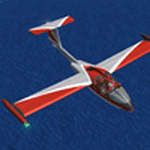
The Machine:
A fully aerobatic, very-light Jet that compares to the Bede BD-5J, but heavier and sporting two instead of one TRS-18 turbojets. Up to Mach 0.47 and 650 NM of range, with a service ceiling of 25000ft. A low stall speed (for a jet) makes the aircraft good for short field operations.
Certified for VFR operations only, yet includes a good avionics suite.
This is a "Classic" aircraft featuring "Steam" gauges and radios. Yet, controls and systems are easy to operate.
The History:
The C-22J is the last aircraft to be adorned with the legendary Caproni name. Originally known as "Caproncino", then marketed as "Ventura". A very-light jet developed in the 1980s as a military trainer, surveillance and reconnaissance aircraft. Powered by two TRS-18 turbojets fed from a dorsal NACA intake, the aircraft reached Mach 0.47 and was fully aerobatic. The airframe shows its origin in a glider design, the Caproni A-21 Calif. After the merger with SIAI Marchetti, the project was cancelled in favor of the SF-260.
The Simulation - 3D Model:
This aircraft ships with a 3-D cockpit, that incorporates realistic night lighting, in the form of a dim dome flood light, backlit gauges and luminous digital displays. The flight crew of 2 is affected by your input in the payloads menu of Flight Simulator, allowing to choose between male, female or empty seats. The Copilot Figure can be hidden with a quick click in the internal 3D view as well.
The Simulation - Realism:
This aircraft has been tuned with the invaluable help of Engineer Carlo Ferrarin, who created the real aircraft. Unique and one-off documentation has been kindly provided, and used extensively, for the creation of this product!
Just like the real aircraft, the systems are simple and of easy operation. Engines can be started with the press of a button. Systems modelling allows the following of real-world checklists as closely as Flight Simulator allows. An in-sim checklist is included, as well as a full flight manual.
The flight model is tuned with advanced aerospace techniques, resulting in a highly realistic aircraft, yet, it is very pleasant to fly, both during aerobatic displays or "A to B" cruising.
Highlights:
- High-Resolution 3D cockpit
- Full Documentation
- Aerobatic
FS-2004 Version comes with limited support and is free due to platform limitations. See Readme. FS-X & P3Dv4 (64-bit) versions are commercial products.
| Filename: | CaproniVizzola_C22J_Ventura.zip |
| License: | Freeware, limited distribution |
| Added: | 7th November 2020, 18:31:45 |
| Downloads: | 681 |
| Author: | Mario Noriega |
| Size: | 157.85 MB |
| Category: Flight Simulator X - AFCAD Files | |
| Princeton Airport (39N), NJ |
|
File Description:
Located 03 miles N of Princeton/Rocky Hill, New Jersey on 100 acres of land, Princeton Airport is a public airstrip. Fuel is available by parking next to the fuel tank - make sure you leave yourself enough room to get back out! (The block of static aircraft parked near the fuel area have collision disabled). This airport offers hangar space for transient aircraft, and as such 5 hangars are open that you can park in - the large hanger and the 4 surrounding it, 2 to the north and 2 to the south. The large hangar has operating doors - the frequency to open them is posted on the hangar doors. You can also choose to start in one of the hangars by selecting a DOCK parking space when positioning yourself at the airport. Docks 16 & 17 are the two small north hangars, Dock 20 is the large central hangar and Docks 18 & 19 are the two small south hangars.
Scenery constructed with use of satellite images/streetview, the author has not been there in person.
This scenery is meant to be used in conjunction with MegaScenery Earth New Jersey/Delaware 001. It is not required, but apron use is minimized to allow satellite scenery to show through as much as possible, and objects are placed based on the MSE textures - lack of it may make scenery look out of place.
| Filename: | Princeton_Airport_39N_NJ.zip |
| License: | Freeware |
| Added: | 21st November 2010, 09:01:50 |
| Downloads: | 311 |
| Author: | Drew Sikora |
| Size: | 1.26 MB |
| Category: Flight Simulator 2004 - Aircraft Repaints, Textures and Modifications | |
| AeroSur Boeing 767-284/ER "Sharko" (CP-2659) |
|
Images related to this file:
File Description:
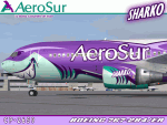
I am quite proud to present this very detailed and accurate repaint of Aerosur's Boeing 767-284/ER logojet named "Sharko", in the Project Opensky B762 V4 model. This logojet of Aerosur of Bolivia turns heads wherever she goes. She joins a rather large group of other AeroSur logojets, forming a total complement of 8. This aircraft flies into Miami (KMIA) and Dulles (KIAD) in the USA.
This repaint is almost 100% hand painted. All artwork is hand rendered except the AeroSur Eagle logo. Custom textures included in this repaint are; hand-painted realistic 3D windows with window shades, custom tires, custom night textures (and alpha), custom fuselage shading, tug with AeroSur logo, stewardess is a an actual AeroSur stewardess in AeroSur uniform, interior exit signs in Spanish (SALIDA), custom fuselage shading and many others. The screen shots included with this package showcase this detailed repaint and the outstanding Miami International Airport (KMIA) scenery recently released by LatinVFR. Fuselage, engine, wing and tail textures are 32-bit with no mips for best clarity and quality. As this has been one of the most enjoyable and challenging repaints for me, I hope you enjoy flying this wonderful aircraft as much as I did creating it. This is a complete install and contains all Project Opensky provided files current to Version 2004.8.0. The sound is from the default B737.
| Filename: | AeroSur_Boeing_767284ER__Sharko_CP2659.zip |
| License: | Freeware, limited distribution |
| Added: | 4th March 2012, 06:52:06 |
| Downloads: | 679 |
| Author: | Jeffrey S. Bryner, Project Opensky |
| Size: | 13.9 MB |
| Category: Flight Simulator 2004 - Scenery | |
| Nicholson Peninsula CWNP & Liverpool Bay CWLB DEW sites in Northwest Territories, Canada |
|
Images related to this file:
File Description:
These are DEW line sites in northern mainland Canada, to the east of Tuktoyaktuk.
Nicholson Peninsula is 100 miles east of Tuktoyaktuk and was not included in FS9. The peninsula is sometimes more like an island than a peninsula as it is barely connected to the mainland and at times is not connected at all (see the current Gogle Earth!). At the northern end there is another long and narrow gravel bar that is formed by the tide and currents and the gravel runway is on the top of this. It is now officially closed, but is still usable. The annual refuelling and maintenance to the NSW station up on the hills is carried out from a barge that lands tanker trucks onto the shore for the drive up the existing gravel roads that have been there since the early DEW station was established.
Liverpool Bay is 50 miles east of Tuktoyaktuk, up on higher land at around 300 feet ASL. The NWS (there was no previous DEW station at this site) is serviced by helicopter from Tuktoyaktuk or from a barge a mile away on the beach. There is a gravel landing pad on the north side of the station. To answer your question, the three little houses on stilts are actually fuel tanks for the generators, shaped to shed snow.
| Filename: | Nicholson_Peninsula_CWNP__Liverpool_Bay_CWLB_DEW_s.zip |
| License: | Freeware, limited distribution |
| Added: | 17th July 2012, 18:55:24 |
| Downloads: | 238 |
| Author: | Roger Wensley |
| Size: | 1.84 MB |
| Category: Flight Simulator X - Aircraft Repaints, Textures and Modifications | |
| Jet Airways Boeing 737NGX (VT-JGX) |
|
Images related to this file:
File Description:

Jet Airways (9W) Boeing 737-75R/WL (VT-JGX) (current Livery) for PMDG 737-700 FSX only (repaint only) (Expansion needed to the original PMDG 737 package)(Payware).
Features:
1. Jet Airways Logo (New Livery with correct positions in referenced to the aircraft)
2. Accurate placement of the Indian Flag.
3. Tail textures were made many times before I was "satisfied". Correct gradient of the vector on the tail
4. Studied and averaged precise sky blue color for fuselage under the ribbons.
5. All colors of the ribbon were sampled by more than 3 pictures.
6. Clean White Engine colors.
7. Hand Drawn to match ribbons and their placement on the fuse. 100% Hand crafted.
8. Accurate winglets.
9. White winglets.
9. Boeing 737-700 decal behind and inline with last exit (in Boeing font and accurate dark blue color).
10.Registration under the dark blue ribbon in accurate position, spacing, font, and color
11.Jet Airways logo flipped correctly (right side).
12.Added dirt textures to wing and aft belly.
13.Registration in accurate place on wing (color and font also studied and accurate).
14.Registration included on bottom of the wing as well.
15.All accurate colors and relative positions to the plane in real life.
16.Lots of Love put in to the project as well
| Filename: | Jet_Airways_Boeing_737NGX_VTJGX.zip |
| License: | Freeware, limited distribution |
| Added: | 19th January 2015, 19:00:53 |
| Downloads: | 472 |
| Author: | Rohan Patel |
| Size: | 21.27 MB |
| Category: Flight Simulator 2004 - Scenery | |
| Mackenzie CYZY in British Columbia, Canada |
|
Images related to this file:
File Description:
Mackenzie is around 120 miles west of Peace River and the BC/Alberta border, at the southern end of Williston Lake. The lake is 135 miles long and the population of the town is about 3,500; those figures illustrate typical Canada, a huge area enjoyed by the few. The main occupations relate to timber and mining in some form, plus tourism (in particular winter sports tourism). The airport is 2 miles southwest of the town, with no regular scheduled flights but it is not unusual to find Central Mountain Air there delivering either charter passengers or freight. The single runway is aligned 16-34 and 100 feet wide lit asphalt that is just over 5,000 feet long, with (in 2010 or so) an additional 1,500 feet of gravel. There is PAPI at both ends of the asphalt. The largest operation based at the airfield is a helicopter company, at the northern end of the apron. There is a "mandatory frequency" of 123.5 which is a Canadian invention; you MUST have a radio. There is no control tower at the actual airfield, and if or when there is no response from further afield then you announce your intentions etc. In FS9 there is no way to "switch off or on" the monitoring of a MF radio frequency so you will find that this one is always silent.
| Filename: | Mackenzie_CYZY_in_British_Columbia_Canada.zip |
| License: | Freeware, limited distribution |
| Added: | 27th December 2018, 20:19:05 |
| Downloads: | 135 |
| Author: | Roger Wensley |
| Size: | 19.81 MB |
| Category: Orbiter - Spaceships | |
| Vanguard 1 Add-on for Orbiter |
|
File Description:
Originally a simple nose cone was to be carried aloft, but in July of 1957 it was decided that a small 1.47 kilogram (3.25 pound) test satellite would be used instead to exercise the tracking stations. This test satellite would consist of a simple 16 centimeter (6.4 inch) polished aluminum alloy sphere equipped with two transmitters operating at frequencies around 108 MHz, 6 small solar panels, and 6 dowel like antennas.
The satellite was Vanguard I, in which its successes set the pattern for a multitude of other space ventures in this country and abroad. Vanguard also served as a springboard for scientists to launch several series of space probes to study various aspects of radiation phenomena.
Vanguard I introduced much of the technology that has been applied in other U.S. satellite programs. For example, it proved that solar cells could be used for several years to power radio transmitters. Vanguard's solar cells operated for about seven years, while conventional batteries used to power another onboard transmitter lasted only 20 days.
Now the oldest man-made satellite still in orbit to this day, Vanguard I has been 100 percent successful in meeting all its scientific objectives.
Now you can fly this historical satellite in orbit. Unlike all the US Navy failed attempts, the Orbiter version will always get you there.
| Filename: | Vanguard_1_Addon_for_Orbiter.zip |
| License: | Freeware |
| Added: | 27th September 2004, 16:23:56 |
| Downloads: | 507 |
| Author: | Jim Williams |
| Size: | 1.25 MB |
| Category: Flight Simulator 2004 - Scenery | |
| Mustique TVSM in the Grenadines |
|
Images related to this file:
File Description:
Mustique island is one of the northernmost of the group of islands known as the Grenadines, just south of Bequia. Mustique is a small island, less than 3 miles long and even at its widest less than a mile wide; as a result the resident population is less than 500. The island is unique in that it is owned by a company. The company is owned, in its turn, by the owners of the 100 or so private villas on the island. The Queen of England is one owner; her participation is balanced out by Jeremy Clarkson.
The airport is at the northern end of the island; the runway is around 3,240 feet long, aligned 09 (and with the southeast trade winds it is most unlikely that you will ever find yourself using 27) and with a steep and displaced threshold of over 900 feet. The displaced threshold is shown but unfortunately FS9 is not capable of coping with anything other than a prefectly flat airport. The terminal is a steel-framed shed with cladding, but is "quaintly" transformed with a palm frond roof etc. There are connecting flights by SVG to Barbados and the other islands and these are reflected in the AI. The airport has no lighting, and flights are obliged to land and depart in daylight hours only, outside of which the airport is closed.
| Filename: | Mustique_TVSM_in_the_Grenadines.zip |
| License: | Freeware, limited distribution |
| Added: | 11th June 2013, 22:57:37 |
| Downloads: | 515 |
| Author: | Roger Wensley |
| Size: | 2.07 MB |
| Category: Flight Simulator X - Scenery | |
| RNAS Henstridge (HMS Dipper) |
|
File Description:
Royal Naval Air Station Henstridge or RNAS Henstridge (HMS Dipper) is a former Fleet Air Arm base located 7 miles (11 km) west of Shaftesbury, Dorset (Now Somerset) and 12.4 miles (20.0 km) east of Yeovil, Somerset in South West England.
The main part of the land (355 acres) was purchased in August 1941, after which building of the airfield and the marsh lane accommodation site commenced, it was commissioned on April 1, 1943 as HMS Dipper, principally as number 2 naval fighter school, on the 11th September 1942, another 18 acres was acquired at the adjoining gibbs marsh area for an aircraft repair and maintenance site. The design and lay-out of the airfield was quite unique, having 5 runways, 2 of these being east west lay-out (07-25) both 1000 yards long, the northern runway incorporated a dummy deck landing strip, complete with under-ground arresting gear with four above ground arrestor wires, which was a duplicate of that installed on HMS Implacable for training of aircraft carrier landings, these mainly being carried out with the Seafire, a naval version of the spitfire with folding wings. The site also had its own cinema and stage hall
March 1952 the airfield became inactive and was placed under care and maintenance, during 1953 Air whaling (now Bristow group) used the facilities for repairs to the whaling fleet of helicopters until moving out in June 1958.June 1957 it was finally closed as a naval establishment, from 1958-1960 the entire site was sold off. 27 June 1980 the BBC purchased the whole site and applied for planning permission to erect at the airfield a shortwave radio station consisting of 21 self-supporting towers holding aerial arrays and ancillary buildings on a 300-acre site. The station would transmit overseas radio services to Eastern Europe, the Soviet Union and perhaps South America the application failed and the BBC sold the land during January 1987 The airfield is also the home of the wessex strut, a general aviation club formed in January 1977, which holds an annual fly in and other events their first fly-in was on 17 April 1977 and attracted 107 aircraft. As of today the only usable runway is the north 07-25 runway, extant with the concrete dummy deck, and the underground machinery chamber, it is also the home to a large number of light aviation enthusiasts aircraft as well as the Yakolevs aerobatic display team and the Dorset and Somerset air ambulance
The current airfield is operated by EGHS and is an unlicensed airfield. The only usable runway is 07/25 tarmac/concrete 750 mts long x 6 mtr wide. Henstridge radio can be contacted on 130.250 MHz, it can be found at the south eastern stub of the Yeovilton MATZ
Source:Wikipedia
| Filename: | RNAS_Henstridge_HMS_Dipper.zip |
| License: | Freeware |
| Added: | 9th February 2017, 22:14:54 |
| Downloads: | 165 |
| Author: | Terry Boissel |
| Size: | 4.53 MB |


© 2001-2026 AVSIM Online
All Rights Reserved
Privacy Policy |