
Where Flight Simulation Enthusiasts Gather from Around the World!
AVSIM Library - Search Results

| Category: Flight Simulator X - Scenery | |
| California Central Coast Scenery for FSX with Megascenery Earth (Default Mesh Terrain) |

|
Images related to this file:
File Description:
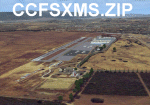
Revised 1/7/10 for upload to Avsim.COM. CCFSXMSFix is incorporated so not required.
This is an earlier version of CCC Megascenery Earth scenery that doesn't require FSGenesis Mesh Terrain. See CCFSXMSG.ZIP for the FSGenesis Mesh version.
This scenery covers the California coastal region from N36���°10' (Coalinga) to N34���°25' (Santa Barbara) and from the coast East to W119���°40'. It is a version of my previous California Central Coast scenery redesigned and expanded to work with MegaScenery Earth from PC Aviator Inc. Many airstrips in the area covered by this scenery have been added or enhanced for a total of 27 airports/airstrips in the area. Several areas of interest such as the Santa Barbara marina, Morro Bay, etc. are also included for a total of 41 points of interest. All airports/airstrips and related structures have been adjusted and realigned to conform to actual positions and dimensions as indicated by the MegaScenery satellite textures. In addition, there are 6 invisible water runways for use by AI floatplane traffic. MegaScenery California-13, -14 and -15 are required for this scenery to make sense. I also used California-12, -28 and -29 when constructing the scenery but they could be considered optional.
| Filename: | California_Central_Coast_Scenery_for_FSX_with_Mega.zip |
| License: | Freeware |
| Added: | 7th January 2010, 21:28:45 |
| Downloads: | 1,559 |
| Author: | Al Wheeler |
| Size: | 8.12 MB |
| Category: Flight Simulator 2004 - AI Flight Plans | |
| West Coast Charters |
|
File Description:
These are realistic flight plans for the 19 aircraft operated by West Coast Charters. Aircraft are based out of Santa Ana, Long Beach, and Van Nuys, California.
| Filename: | West_Coast_Charters.zip |
| License: | Freeware |
| Added: | 17th February 2009, 19:40:26 |
| Downloads: | 409 |
| Author: | Mark McCoy |
| Size: | 4.24 KB |
| Category: Flight Simulator X - Scenery | |
| Crosswind Runways for California Central Coast Scenery for FSX with CCFSXMSG.ZIP or CCFSXMS.ZIP Installed |
|
Images related to this file:
File Description:
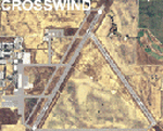
This scenery contains several revised files for my previously uploaded California Central Coast sceneries CCFSXMSG.ZIP and CCFSXMS.ZIP. These are the versions of my CCC scenery for FSX with MegaScenery Earth. The "G" version also requires Genesis Terrain Mesh but is the most complete version. Included here are revised AFCAD files for the major airports in those sceneries which will add interesting crosswind capability to C80, PRB, SBP, SMX and SBA airports. Additionaly, revised AFCAD and associated files for IZA, LPC, L52 and VBG are included. In some cases ground traffic has been added, a few glitches repaired and minor improvements effected. The crosswind AFCAD's for the 5 airports with tangential or crossing runways were revised using the technique developed by Jim Vile and executed by Airport Design Editor (ADEX). This procedure will unavoidably bolix up the ATIS runway advisories at the 3 tower controlled airports with ATIS (SBA, SBP and SMX) but will make all of the runways useable for AI traffic depending on wind conditions. This is not a problem at C80 and PRB since they are uncontrolled fields and have no ATIS available. Therefore, I've included revised AFCADs for SBA, SBP and SMX that do not have crosswind provisions that can be substituted if desired.
| Filename: | Crosswind_Runways_for_California_Central_Coast_Sce.zip |
| License: | Freeware |
| Added: | 7th January 2010, 22:05:25 |
| Downloads: | 514 |
| Author: | Al Wheeler |
| Size: | 194.42 KB |
| Category: Flight Simulator 2004 - Scenery | |
| Landclass Scenery |
|
File Description:
FS2004 Land Class scenery that covers the area between San Luis Obispo to Oxnard California. All towns in this area and that extend east of the coast are also included.
| Filename: | Landclass_Scenery.zip |
| License: | Freeware |
| Added: | 11th October 2008, 02:12:15 |
| Downloads: | 1,694 |
| Author: | Charles Reid |
| Size: | 3.52 MB |
| Category: Flight Simulator 2004 - Scenery | |
| Hazardous Airstrips of the Santa Lucia Mountains |
|
File Description:
This is a package of four airstrips located near the central California coast. They have been constructed in a variety of inaccessible places: tucked away in ravines and narrow canyons, or perched high on an outcrop of rock. All are at least as difficult as many of the backwoods airfields in the Idaho Rockies, such as Dewey Moore, Cabin Creek, or Lower Loon. Special yellow arrows painted on the hillside assist in guiding you down your approach to each runway.
| Filename: | Hazardous_Airstrips_of_the_Santa_Lucia_Mountains.zip |
| License: | Freeware, limited distribution |
| Added: | 31st January 2004, 07:00:47 |
| Downloads: | 1,971 |
| Author: | James Belk |
| Size: | 3.12 MB |
| Category: Flight Simulator 2004 - Scenery | |
| KHAF - Half Moon Bay Airport - San Mateo County, California - USA |
|
Images related to this file:
File Description:
FS2004 Scenery - Half Moon Bay Airport (IATA: HAF, ICAO: KHAF, FAA LID: HAF) is a county-owned public use airport in San Mateo County, California, United States. It is located five nautical miles (9 km) northwest of the central business district of Half Moon Bay, California. The airport is on the Pacific Coast, south of San Francisco. The Half Moon Bay Airport is located approximately 20 miles south of San Francisco. It was constructed by the California State Highway Department for the U.S. Army in 1942 as an auxiliary airfield for Salinas Army Air Base. Following the end of World War II, San Mateo County acquired the airport from the Navy in 1947. The airport has served a variety of roles over the years and is currently an important business, transportation and emergency service asset to the community. For your flying pleasure by John B. Loney, Jr.
| Filename: | KHAF__Half_Moon_Bay_Airport__San_Mateo_County_Cali.zip |
| License: | Freeware, limited distribution |
| Added: | 5th August 2015, 18:58:17 |
| Downloads: | 318 |
| Author: | John B. Loney, Jr. |
| Size: | 11.87 MB |
| Category: Flight Simulator X - Scenery | |
| KHAF - Half Moon Bay Airport - San Mateo County, California - USA |
|
Images related to this file:
File Description:
FSX Scenery - Half Moon Bay Airport (IATA: HAF, ICAO: KHAF, FAA LID: HAF) is a county-owned public use airport in San Mateo County, California, United States. It is located five nautical miles (9 km) northwest of the central business district of Half Moon Bay, California. The airport is on the Pacific Coast, south of San Francisco. The Half Moon Bay Airport is located approximately 20 miles south of San Francisco. It was constructed by the California State Highway Department for the U.S. Army in 1942 as an auxiliary airfield for Salinas Army Air Base. Following the end of World War II, San Mateo County acquired the airport from the Navy in 1947. The airport has served a variety of roles over the years and is currently an important business, transportation and emergency service asset to the community. For your flying pleasure by John B. Loney, Jr.
| Filename: | KHAF__Half_Moon_Bay_Airport__San_Mateo_County_Cali.zip |
| License: | Freeware, limited distribution |
| Added: | 5th August 2015, 18:57:47 |
| Downloads: | 916 |
| Author: | John B. Loney, Jr. |
| Size: | 10.69 MB |
| Category: Flight Simulator 2004 - Scenery | |
| Bodega Bay, California Scenery |
|
File Description:
Bodega Bay, California for FS2004
Represents Bodega Bay on the Sonoma coast of California, with due homage to the 1963 Alfred Hitchcock movie, "The Birds" - so it's more artistic than realistic! REQUIRES Lago FSE (payware) and includes local landclass. Lots of eye candy in this one. Please unzip (using folders option) to a temporary folder and follow the instructions carefully).
| Filename: | Bodega_Bay_California_Scenery.zip |
| License: | Freeware |
| Added: | 14th August 2005, 12:07:58 |
| Downloads: | 770 |
| Author: | John Burford |
| Size: | 149.85 KB |
| Category: Flight Simulator 2004 - Scenery | |
| USA Pack2 |
|
File Description:
FS2002/2004 USA Pack2 Soaring Scenery
This file add some thermals to default Microsoft scenery for several cities of California and Nevada States,USA:
1.San Francisco(KSFO).
2.Los Angeles(KLAX).
3.Las Vegas(KLAS).
4.Crystal,CA(L01) - Great Western Soaring Club.
5.San Diego(CA84) - Associated Glider Club of Southern California.
6.Hemet-Ryan(KHMT) - Cypress Soaring.
7.Skylark Field(CA89) - Lake Elsinore Soaring Club.
8.Truckee(KTRK) - Soar Truckee.
9.Hollister(3O7) - Hollister Gliding Club.
10.California City(L71) - Caracoles Soaring.
11.Chico Mun(KCIC) - Chico Soaring
12.Avenal(CA69) - Central California Soaring Club.
It is freeware.
By Francisco Vargas.
E-mail:[email protected]
| Filename: | USA_Pack2.zip |
| License: | Freeware |
| Added: | 5th November 2005, 15:47:32 |
| Downloads: | 2,556 |
| Author: | Francisco Augusto Vargas Carneiro |
| Size: | 1.33 MB |
| Category: Flight Simulator 2004 - AI Flight Plans | |
| Kona Shuttle - Summer 2013 |
|
Images related to this file:
File Description:

Kona Shuttle is a private all first-class operation that flies solely from Oakland, California to Kona, Hawaii ferrying residents of three exclusive developments on the North Kona coast of the Big Island of Hawaii, The Four Seasons Resort Hualalai, Kukio, and Mauna Lani.
| Filename: | Kona_Shuttle__Summer_2013.zip |
| License: | Freeware, limited distribution |
| Added: | 28th August 2013, 01:12:02 |
| Downloads: | 502 |
| Author: | Ben Clark |
| Size: | 4.38 KB |
© 2001-2026 AVSIM Online
All Rights Reserved
Privacy Policy |