
Where Flight Simulation Enthusiasts Gather from Around the World!
AVSIM Library - Search Results

| Category: Flight Simulator X - Scenery | |
| KSNA, John Wayne-Orange County Airport |

|
Images related to this file:
File Description:

John Wayne Airport (IATA: SNA, ICAO: KSNA, FAA LID: SNA) is an airport in an unincorporated area in Orange County, California, with its mailing address in the city of Santa Ana, which is also the county seat, hence the International Air Transport Association (IATA) airport code. The main entrance to the airport is off of MacArthur Blvd in Irvine, the city that abuts the airport from the north and east. Newport Beach and Costa Mesa form the southern and western boundaries, respectively, together with a small unincorporated area along the Corona del Mar (73) Freeway. Santa Ana lies just north, not actually touching the airport directly. Originally named Orange County Airport, the county Board of Supervisors renamed it in 1979 to honor the actor John Wayne, who resided in neighboring Newport Beach and died that year. It also became the first airport to be named after an entertainer.
The main runway, at 5,701 feet (1,738 m), is one of the shortest of any major airport in the United States, resulting in most passenger aircraft operating from the airport to be no larger than the Boeing 757. However, some larger cargo aircraft, such as the FedEx A310/300, fly from SNA. Some gates are built to handle planes up to the size of a Boeing 767, which can operate with payload/fuel load restrictions. No wide-body passenger aircraft are currently in scheduled service at the airport.
| Filename: | KSNA_John_WayneOrange_County_Airport.zip |
| License: | Freeware, limited distribution |
| Added: | 11th October 2011, 08:25:20 |
| Downloads: | 11,001 |
| Author: | Mateusz Stabryla MK-Studios |
| Size: | 66.92 MB |
| Category: Flight Simulator 2004 - Scenery | |
| Kaltag KAL in Alaska |
|
Images related to this file:
File Description:
Kaltag is a small village on the west bank of the Yukon River, around 65 miles east of the coast at Unalakleet and about 40 miles south of where the river turns from north-south to east-west, east being upstream towards the distant Fairbanks. The population is just under 200 and living from fishing and the land. The airfield is close by and has a gravel runway aligned 21-3 and just under 5,000 feet long. Apart from the airfield itself, and it's buildings, this scenery modifies the local land class, adds village buildings while reducing the village size to reality, and creates a new airfield background. Kaltag is located on the edge of three different airlines coverage areas, and is served by Bering Air from the northwest, ERA from the southwest, and also by Wright Air from Fairbanks in the east. These are included in the AI.
A note here about my scenery making. This is post number 507 and there will not be many more to follow this as I am almost at the end of the photos I either took or found for scenery purposes. There is a limit to what can be located online and I have already been making use of the little there is; eg Unalakleet. So, if you are near an airport (preferably Canadian or Alaskan) and have a camera..... Let me know.
| Filename: | Kaltag_KAL_in_Alaska.zip |
| License: | Freeware, limited distribution |
| Added: | 20th August 2019, 19:04:35 |
| Downloads: | 101 |
| Author: | Roger Wensley |
| Size: | 3.57 MB |
| Category: Flight Simulator X - Scenery | |
| YEEB Eneabba, Western Australia strip and townsite |
|
File Description:
YEEB Eneabba strip and townsite
Sand mining town in heart of wildflower area Located 278 km north from Perth via the Brand Highway, Eneabba is basically a sand mining town surrounded by some of the most extensive and spectacular wild flower displays anywhere in Western Australia. The town itself is, to be fair, a real non-event with dreary modern housing (with more than a hint of construction town design), a small shopping centre and a service station all of which look as though they have sprung up in the last 20-30 years. The wealth of the area is based on the rutile sands which lie to the south of the town as well as farming, particularly cattle grazing. With an estimated 80 per cent of the world's known rutile supplies the town can boast that it has the biggest deposits of rutile in both Australia and the world. The major mining company in the area is Iluka Resources Ltd. Eneabba is basically a service town for the mines but some of the miners, realising that Eneabba is hardly a paradise, have opted for commuting and live on the coast at Leeman and drive to work preferring the beach to the dry inland.
REQUIRES blencowe_librarykit_309494.zip (Available HERE)
| Filename: | YEEB_Eneabba_Western_Australia_strip_and_townsite.zip |
| License: | Freeware |
| Added: | 25th February 2013, 23:48:24 |
| Downloads: | 255 |
| Author: | Alan Blencowe |
| Size: | 3.59 MB |
| Category: Flight Simulator 2004 - Scenery | |
| VFR of Lario, Area C2A - Como lake, Italy |
|
Images related to this file:
File Description:
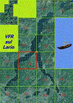
*** REPLACEMENT OF PREVIOUS ISSUE, due to a bug of an High Winter texture ***
This is the fifth scenery of the "VFR of Lario" project, made with photorealistic terrain (multiseason & night) and with some 3D GMax realistic objects.
Information: Como's lake is in the north of Italy, closed to the Helvetic border; this scenery covers approximately an area of 7.5x6 kmt, from la "Zoca de l'Oli" and mountains over Ossuccio (NW) to Tremezzo (NE), and from Colonno (SW) to Magreglio (SE) and includes the NLC piers of Sala Comacina, Comacina island, Campo, Lenno, Tremezzo, Bellagio (2), S. Giovanni, Lezzeno; it includes several dedicated buildings as Taverna Bleu hotel (Sala Comacina), S. Maria e S.Giacomo churches and villa Balbiano (Ossuccio), church and pier of S. Michele (Colonno), villa del Balbianello (Lenno), hotel Villa Marie, S. Lorenzo Church, villa La Quiete, Grand Hotel, villa Carlotta, hotel La Darsena, Pub motor ship Bisbino (Tremezzo), villa Melzi, villa Giulia, buildings Carillon e lungolago Manzoni, hotels Excelsior, Du Lac, Metropole (Bellagio). Two NLC ferry (moted on the way Bellagio-Cadenabbia) are placed together with other minor boats and docks placed alongside the coast, including platforms for seaplanes arrival.
Contents: GMax objects as above and other buildings, minor piers and boats together with autogen buildings and trees are fully spreaded on the scenery.
| Filename: | VFR_of_Lario_Area_C2A__Como_lake_Italy.zip |
| License: | Freeware |
| Added: | 22nd May 2012, 18:12:41 |
| Downloads: | 1,669 |
| Author: | Aldo Della Vedova, Daniele Lanfranchi, Gian Mario Verga, Diego Caligiuri |
| Size: | 28.49 MB |
| Category: Flight Simulator 2004 - Scenery | |
| Haines Junction CYHT in Yukon Territory Canada |
|
Images related to this file:
File Description:
Haines Junction is a village in the Yukon Territory, Canada, amid the Rocky Mountains and around 80 miles west of Whitehorse. It is sited at the junction of the Haines Highway and the Alaska Highway, hence the name. The village was established in 1942 when the Alaska Highway was under construction, and the Haines Highway was built over the Chilkat Pass to connect to the town of Haines on the Alaska coast.
The date of this scenery is, as usual, around 2010. At that time there was a regular service (not always a daily one, depending on the time of year) by Yukon Air North, and in this case it is by an ATR 42-300. There is a helicopter company based at the airfield, Trans North Helicopters, and there is also Kluane Glacier Air Tours, which, as the name suggests, takes you to a glacier so you can stroll around on ice. And then brings you back. The gravel runway is 5,000 feet long and aligned 04-22, and is lit, with PAPI at both ends. Right hand circuits are required for runway 04 as the terrain is not flat.
This post will be followed by two other airfields to the northwest, Silver City and Burwash, both of which are on or close to the Alaska Highway.
| Filename: | Haines_Junction_CYHT_in_Yukon_Territory_Canada.zip |
| License: | Freeware, limited distribution |
| Added: | 22nd January 2022, 21:53:16 |
| Downloads: | 115 |
| Author: | Roger Wensley |
| Size: | 20.46 MB |
| Category: Flight Simulator X - Scenery | |
| 63 AI Ships and AI Ship Traffic for South America and Europe V1 |
|
Images related to this file:
File Description:

Plenty of good designers have created beautiful navy ships and aircraft carriers for FSX, but only few have created container ships, tankers, off-shore supply ships, tugs, or bulk carriers and put them to sail around the globe in FSX. With this package I intend to fill a part of this gap and to bring more life to the mostly empty oceans in FSX by providing AI ships and AI traffic files with a fleet of modern merchant ships travelling through some of the most heavily trafficked sea routes in the world. The pack contains 63 AI ships based on more than 35 different GMAX models. Around one third are equipped with landable helicopter decks. Most ships have simple animations like rotating radars and most have custom light, smoke and wake effects. The pack also contains traffic files for the east coast of South America and the coasts of North West Europe: In South America ships visit Belem, Sao Louis, Natal, Recife, Salvador, Macae, Rio de Janeiro, Santos, Florianopolis, Pelotas, Porto Alegre, Montevideo, Buenos Aires and Puerto Madryn. In Europe ships visit Gibraltar, Algeciras, Lissabon, Bordeaux, La Rochelle, Saint Nazaire, Brest, Le Havre, Antwerp, Rotterdam, Amsterdam, Thamesport, Felixstowe, Bremerhaven, Hamburg, Esbjerg, Oslo, Aarhus, Copenhagen and St.Petersburg. For map of coverage, routes and ship details see the PDF manual.
| Filename: | 63_AI_Ships_and_AI_Ship_Traffic_for_South_America_.zip |
| License: | Freeware |
| Added: | 3rd March 2013, 16:37:41 |
| Downloads: | 23,946 |
| Author: | Henrik Nielsen |
| Size: | 17.24 MB |
| Category: Flight Simulator 2004 - Scenery | |
| Terrace CYXT Updated |
|
Images related to this file:
File Description:
This revises the previous versions by adding two missing buildings, corrects the apron markings and parking and adds a third gate, creates more GA parking, updates the AI to include, for instance, a Westjet flight, and most importantly of all adds the ILS to runway 33. It is complete in itself and can be installed as-is without first installing previous versions. Terrace is fifteen miles east and inland from Prince Rupert, which is 500 miles north of Vancouver up the BC coast. It is at the point in the mountains where two fjords meet, one coming from Prince Rupert and the other from Kitimat. The population of the town is around 12,500. The airport is called Terrace-Kitimat and is a couple of miles south of the town of Terrace, on the south side of the Skeena River. There are two runways, and the main one is a recently-extended 7,500 feet long and lit 33-15 with approach lighting to both ends and an ILS on 33. The second is 5,373 feet of unlit 03-21. The apron has been enlarged to be able to accommodate a Boeing 737, though there is at the moment no airline using a 737 for flights to Terrace. The pics and the video show the surrounding hilly terrain and the nearby river between the airport and the town.
| Filename: | Terrace_CYXT_Updated.zip |
| License: | Freeware, limited distribution |
| Added: | 13th January 2019, 18:38:12 |
| Downloads: | 176 |
| Author: | Roger Wensley |
| Size: | 15.64 MB |
| Category: Flight Simulator 2004 - Scenery | |
| Chignik Lake A79 and Port Heiden PAPH - Alaska, USA |
|
Images related to this file:
File Description:
These are two villages in Alaska, in the peninsula that is the start of the Aleutians. Both are east of Perryville, Chignik Lake by 30 miles on the south side of the peninsula and Port Heiden by 75 miles on the north coast. Both are served by Grant Aviation government-subsidised regional flights from King Salmon. Chignik Lake has a population of around 70. There are two buildings on the airfield, but passengers still wait in their car for the plane to arrive as there is no terminal building as such. The runway is 3,300 feet of gravel aligned 08-26, as are so many in this area. Port Heiden is on the north shore of the peninsula, and the population is around 100. FS9 showed the town as being large enough to house 10,000; the new landclass here reduces this to the actual 40 or so houses, one and a half miles south of the airport. The roads are still the FS9 originals, which are approximately in the right place but are brightly lit at night as I was too lazy. The main occupation is fishing. There are buildings on the airfield (mostly old, except for a garage building) but passengers again wait in their cars for the plane to arrive. The two runways are both gravel, and are 05-23 of 6,200 feet, and 13-31 of 4,400 feet.
| Filename: | Chignik_Lake_A79_and_Port_Heiden_PAPH__Alaska_USA.zip |
| License: | Freeware, limited distribution |
| Added: | 30th March 2015, 20:28:47 |
| Downloads: | 291 |
| Author: | Roger Wensley |
| Size: | 5.1 MB |
| Category: Flight Simulator 2004 - Scenery | |
| Coffs Harbour (YSCH), NSW, Australia |
|
File Description:
Coffs Harbour Regional Airport (YSCH) FS2004
********************************************
Coffs Harbour airport, located roughly halfway between Sydney and Brisbane on the East coast of Australia, is owned and operated by Coffs Harbour Council. They took over the airport in the early nineties and after a massive expansion plan including widening the runway to handle jets up to a Boeing 767 and building a new terminal at a cost of $4 million dollars. This terminal was opened in November 2000 and should handle the expanding traffic for the next 10 years. At present over 200,000 passengers pass through the terminal.
The scenery re-creates the entire airport for FS2004 including the new terminal, old terminal, all of the ga hangars, flying school, airport tower and many more structures. All modelling was carried out using textures from photographs taken on site to ensure an authentic result. In addition the harbour at Coffs Harbour has been modelled as well as Mutton Bird Island that was missing completely in the default. To conserve frame rates the harbour has not been fully detailed but is accurate in placement and looks realistic on an approach to runway 21.
AFCAD file and traffic tools file is included to populate the airport with additional AI traffic. Also contains three sample flights, which can be selected from the flight simulator select flight menu.
| Filename: | Coffs_Harbour_YSCH_NSW_Australia.zip |
| License: | Freeware |
| Added: | 2nd July 2004, 20:08:19 |
| Downloads: | 4,999 |
| Author: | John Ross |
| Size: | 8.17 MB |
| Category: Flight Simulator 2004 - Scenery | |
| HLLQ El Beida/Labraq |
|
Images related to this file:
File Description:
Googly scenery for HLLQ El Beida/Labraq - a joint civilian and military airport
near the north coast of Libya that is poorly provided for in Flight Simulator
2004. These scenery files add taxiways, aprons, buildings and other airport
features, so that you and your "AI" traffic can land, taxi, park and take off
in a realistic manner.
The city of Al Beida, or Al Bayda' or El Beda or Al Baidhah (depending on who
you are) has achieved its own airport status by using the end of a dead runway
at Labraq Air Base. In turn the airbase has contracted to use the opposite end
of the runway as its base of activity. The city is served by jets of Libyan
Airways and turboprop craft of Air One Nine and Ghadames Air Transport.
The scenery does not purport to be ultra-accurate. Based on high-detail satellite
imagery from Google Earth, the layout is proportionally correct but the added
airport features, such as buildings, are built from default Microsoft objects
and add-on libraries so will not look like the real thing.
You are not obliged to download and install any additional scenery libraries,
but to enjoy this scenery in its entirety, you may wish to. It will work fine,
with or without. [File re-uploaded at request of AVSIM]
| Filename: | HLLQ_El_BeidaLabraq.zip |
| License: | Freeware |
| Added: | 28th May 2010, 20:42:26 |
| Downloads: | 1,286 |
| Author: | John Hinson |
| Size: | 73.79 KB |
© 2001-2026 AVSIM Online
All Rights Reserved
Privacy Policy |