
Where Flight Simulation Enthusiasts Gather from Around the World!
AVSIM Library - Search Results

| Category: Flight Simulator X - Scenery | |
| LGLS - Lousoi Airfield **Fictional** |

|
Images related to this file:
File Description:
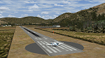
An imaginary airfield in north central Peloponnese Greece named after the elevated mountain plain where it would be situated. LGLS Lousoi airfield has a 1,000m runway at elevation of 3,186ft surrounded by mountains.
The aiport is equiped with NDB, ILS DME, PAPIs and night lighting for instrument approaches; approach chart included.
As bonus two imaginary helipads LGKK Kleitoria and LGPP Planitero are added in the nearby two villages.
All are infrastructure I wish they existed in the area since I drive there often for vacations in Planitero and always wondered how it would be if I could fly there. Planitero sits at the south footings of Chelmos mountain, the highest peak in the area. No AI traffic plans included.
| Filename: | LGLS__Lousoi_Airfield_Fictional.zip |
| License: | Freeware, limited distribution |
| Added: | 15th April 2015, 01:07:43 |
| Downloads: | 138 |
| Author: | Kyprianos Biris |
| Size: | 1.87 MB |
| Category: Flight Simulator 2004 - AI Flight Plans | |
| RAF ASTOR Raytheon Sentinel R1 flightplans |
|
File Description:
This is an attempt to represent the RAF ASTOR Raytheon Sentinel R1 aircraft, which is essentially a modified Bombardier Global Express with various lumps and bumps housing its surveillance equipment. I cannot vouch for the accuracy - all info has been researched from the web.
The flights operate from EGXW Waddington, England, and include active duty in the Middle East, training in California/Nevada (notably at KNID China Lake NAWS), and also the odd visit to Raytheon at KGVT Majors, Greenville, Texas and EGNR Hawarden/Broughton, England. The included patrols over Afghanistan have been implemented by using waypoints where "ai missed approaches" will occur. Instrument approach training (with missed approaches) is also conducted at many UK civil and military airfields, as per the evidence from Airliners.net. Complements my Nimrod flightplans also on Avsim.
| Filename: | RAF_ASTOR_Raytheon_Sentinel_R1_flightplans.zip |
| License: | Freeware |
| Added: | 14th April 2009, 14:03:12 |
| Downloads: | 1,018 |
| Author: | Dan Foster |
| Size: | 4.14 KB |
| Category: Flight Simulator 2004 - Flight Plans | |
| OB-10 Hawthorne Nevada |
|
Images related to this file:
File Description:
FS2004 Flight Plan for OB-10 Hawthorne Nevada IFR high speed low altitude military training route. This is the third in a series of flight plans I have uploaded . This route goes through both mountainous and flat and rolling terrain in California, and Nevada. These are great routes for B-52, F-111, B-1B, B-2 A6, A4, Vulcan and any fighter or bomber enthusiasts. Of course you can fly the route with any aircraft of your choice. Included in this package is a gauges by Karol Chlebowski for TFR flying at very low altitude. This gauge will greatly enhance your ability to fly these challenging routes and is a great companion of the flight plans. Another option to download Version 2.0 of my FS2004 mini panel which has all this functionality and more.
| Filename: | OB10_Hawthorne_Nevada.zip |
| License: | Freeware |
| Added: | 27th July 2011, 23:00:38 |
| Downloads: | 86 |
| Author: | Bill McClellan |
| Size: | 458.56 KB |
| Category: Flight Simulator 2004 - Scenery | |
| Murray Field KEKA |
|
Images related to this file:
File Description:
FS2004 Scenery - Murray Field (IATA: EKA, ICAO: KEKA, FAA LID: EKA) is a county-owned public-use airport in Humboldt County, California, United States. Murray Field Airport serves Eureka and Humboldt County. The airport has more than one runway. The longest is a paved runway extending 3000 feet. The facility is at an elevation of 7 feet at a distance of about 3 miles from Eureka. The airport is primarily used for general aviation. Also FedEx Express utilizes the small airport as a stop for package delivery from and to Humboldt County. Murray Field was first established in 1919 by pilot Dayton Murray, and was later renamed in his honor. It has a restaurant and a charter service, Northern Air, as well as a Civil Air Patrol office. Created by John B. Loney, Jr.
| Filename: | Murray_Field_KEKA.zip |
| License: | Freeware, limited distribution |
| Added: | 20th March 2012, 01:35:39 |
| Downloads: | 346 |
| Author: | John B. Loney, Jr. |
| Size: | 5.92 MB |
| Category: X-Plane - Scenery | |
| JERI Jericoacoara CE Brazil v1.0.0 |
|
Images related to this file:
File Description:
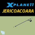
This is an X-Plane 11 scenery for the brand new Jericoacoara Airport (no ICAO nor IATA codes yet, so in X-Plane it is been called JERI) in northern Ceara, Brazil. This is a brand new airport, about to be inaugurated. It serves the northern coast of Ceara state, in Brazil. A region famous by the Jericoacoa Beach, claimed to be among the most beautiful beaches in the world. This scenery was tested and is operational (as of January 03, 2017) in "X-Plane 11 Public Beta #3 64 bits", Windows 10 Home. It was also tested and is also operational (as of January 03, 2017) in "X-Plane 10.51 64 bits", Windows 10 Home.
| Filename: | JERI_Jericoacoara_CE_Brazil_v100.zip |
| License: | Freeware |
| Added: | 3rd January 2017, 23:17:37 |
| Downloads: | 70 |
| Author: | Rui Mesquita |
| Size: | 1.11 MB |
| Category: Flight Simulator X - Aircraft Repaints, Textures and Modifications | |
| De Havilland DH-89 (ZK-AKT) |
|
Images related to this file:
File Description:

This folder contains a repaint for the De Havilland DH89 Dragon Rapide by Dave Garwood. It shows DH89B Dominie #6673 ZK - AKT. This was one of 9 Dominies obtained by the RNZAF, and had the serial NZ530. It was registered ZK - AKT in 1946 and served with NAC until 1956. It was then sold to West Coast Airways who operated it until 1965. It was then flown by NZ Tourist Air Travel until 15 April 1967, when it suffered a twin engine failure, and made a forced landing on the Shotover river bed. The remains were burnt after all salvageable parts were removed. Repaint by Jan Kees Blom, based on the paintkit by Dave Garwood
| Filename: | De_Havilland_DH89_ZKAKT.zip |
| License: | Freeware |
| Added: | 2nd August 2018, 15:12:27 |
| Downloads: | 109 |
| Author: | Jan Kees Blom |
| Size: | 2.58 MB |
| Category: Flight Simulator 2004 - Scenery | |
| VFR of Lario, Area D1 - Como lake, Italy |
|
Images related to this file:
File Description:

This is the sixth scenery of the "VFR of Lario" project, made with photorealistic terrain and some 3D GMax realistic objects. This scenery covers approximately an area of 7.5x6 kmt, from Val Cavargna mountains (NW) to Acquaseria/Sant'Abbondio (NE), and from Galbiga mountain (SW) to Cadenabbia/Griante (SE) and includes the NLC piers of Cadenabbia and Menaggio; it includes several dedicated buildings as S. Rocco church (Griante), NLC ticket-office, statue of Bowler and hotel Britannia (Cadenabbia), villa La Gaeta (S. Siro), Finalcial Police old building, NLC boarding square and Grand Hotel Menaggio (Menaggio). Motor ship Orione at Menaggio pier together with other minor boats and docks alongside the coast. Two little libraries that use default textures are added.
| Filename: | VFR_of_Lario_Area_D1__Como_lake_Italy.zip |
| License: | Freeware |
| Added: | 27th May 2012, 23:32:01 |
| Downloads: | 1,319 |
| Author: | Aldo Della Vedova, Daniele Lanfranchi, Gian Mario Verga, Diego Caligiuri |
| Size: | 13.34 MB |
| Category: Flight Simulator X - AFCAD Files | |
| MHLC - Goloson International Airport - La Ceiba, Honduras |
|
Images related to this file:
File Description:
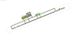
Goloson International Airport (Spanish: Aeropuerto Internacional Goloson) (IATA: LCE, ICAO: MHLC) is an airport located on the western side of the city of La Ceiba, in the Atlantida Department on the north coast of Honduras. It is also known as La Ceiba Airport (Aeropuerto de La Ceiba) and Hector C. Moncada Air Base (Base Aerea Hector C. Moncada). The Airport serves as the headquarters for Aerolineas Sosa.
Features:
*Expanded parking apron
*Taxiways properly designated and aligned
*Runway markings and lighting corrected
*Parking spots for commercial traffic
*Separate parking area for GA traffic
*Misc airport buildings added
*Airport vehicles and objects throughout the airport
*Fuel service vehicles
*Static aircraft
| Filename: | MHLC__Goloson_International_Airport__La_Ceiba_Hond.zip |
| License: | Freeware |
| Added: | 5th February 2014, 23:07:36 |
| Downloads: | 443 |
| Author: | Jaison Diaz / Endeavour AI |
| Size: | 79.61 KB |
| Category: Flight Simulator 2002 - Scenery | |
| Florida Landclass Scenery |
|
File Description:
Moon over Miami.
Fly the Sunshine State under a full moon or in the bright sunshine and you will see a vast improvement in the default scenery if you use the Joe Watson, Bob Brown, Florida Landclass Scenery Files. Created from the U.S. Geological Survey National Landcover Database and hand edited by Joe and Bob this is the most accurate scenery available for the State of Florida. Six individual bgls transform the default scenery into a recognizable landscape as you fly from the Keys, up the East Coast over Miami, and Fort Lauderdale then out over the Everglades on your way past Tampa to the Panhandle all the way to just east of New Orleans near Slidell and Bogalusa.
| Filename: | Florida_Landclass_Scenery.zip |
| License: | Check within download |
| Added: | 4th November 2002, 13:32:49 |
| Downloads: | 6,331 |
| Author: | Bob Brown and Joe Watson |
| Size: | 159.08 KB |
| Category: Flight Simulator 2004 - Flight Plans | |
| FS Nav 4.6 Crete |
|
File Description:
This file is an FS Navigator 4.6 flight plan which will produce a very nice guided tour of the island of Crete. It it has been written with the specific intention of showing off the highlights of Jacques Sylvain's beautiful Crete 2004 scenery. Some of these can be a little difficult to find: my flight plan will automatically take you on the following route, optimising the altitude for best views as you go:
Sitia airport - Ierapetra (south coast) - Lasithi Plain (with windmills) - Knossos Palace - Herakleion airport & Harbour - Mount Idi (birthplace of Zeus!) - Rethymnon Harbour - Chania Harbour - Souda (Chania) airport.
Take off, engage FSNav and the autopilot, then sit back and enjoy Jacques Sylvain's scenery......
| Filename: | FS_Nav_46_Crete.zip |
| License: | Freeware |
| Added: | 28th October 2004, 20:35:08 |
| Downloads: | 1,046 |
| Author: | Martin Stebbing |
| Size: | 1.87 KB |
© 2001-2026 AVSIM Online
All Rights Reserved
Privacy Policy |