
Where Flight Simulation Enthusiasts Gather from Around the World!
AVSIM Library - Search Results

| Category: Flight Simulator 2004 - Scenery | |
| WIOO Pontianak/Supadio, Kalimantan, Indonesia |

|
Images related to this file:
File Description:
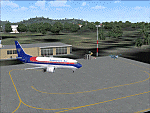
Googly scenery for WIOO Pontianak/Supadio, Kalimantan, Indonesia. In Flight Simulator
2004 only a general aviation parking is provided at this important Indonesian domestic
airport, but in the real world it is served over fifteen times
a day by jets and smaller aircraft of Adam Air, Airfast Service, Batavia Air, Deraya
Air Taxi, Indonesia Air Transport, Sriwijaya Air and Tri-MG Intra Asia Airlines. These
scenery files add aprons, taxiways, buildings and other airport features to Flight
Simulator's limited representation and allow "AI" traffic to land, taxi, park and
take off in a realistic manner.
The scenery does not purport to be ultra-accurate. Based on high-detail satellite
imagery from Google Earth, the layout is proportionally correct but the added
airport features, such as buildings, are built from default Microsoft objects
and add-on libraries so will not look like the real thing.
You are not obliged to download and install any additional scenery libraries,
but to enjoy this scenery in its entirety, you may wish to. It will work fine,
with or without.
[File re-uploaded at request of AVSIM]
| Filename: | WIOO_PontianakSupadio_Kalimantan_Indonesia.zip |
| License: | Freeware |
| Added: | 15th May 2010, 01:10:01 |
| Downloads: | 1,962 |
| Author: | John Hinson |
| Size: | 64.96 KB |
| Category: Flight Simulator 2004 - Scenery | |
| WAML Palu/Mutiara, Indonesia |
|
Images related to this file:
File Description:
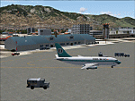
Googly scenery for WAML Palu/Mutiara, Indonesia. In Flight Simulator 2004 little
is provided other than a runway at this small domestic airport, although in the
real world it sees regular jet flights from airlines such as Batavia Air, Bouraq
Indonesia Airlines, Garuda Citylink, Lion Airlines and Merpati Nusentara and
smaller aircraft from operators like Airfast Service and Indonesia Air Transport.
These scenery files add aprons, taxiways, buildings and other airport features
to Flight Simulator's limited representation and allow "AI" traffic to land,
taxi, park and take off in a realistic manner.
The scenery does not purport to be ultra-accurate. Based on high-detail satellite
imagery from Google Earth, the layout is proportionally correct but the added
airport features, such as buildings, are built from default Microsoft objects
and add-on libraries so will not look exactly like the real thing.
You are not obliged to download and install any additional scenery libraries,
but to enjoy this scenery in its entirety, you may wish to. It will work fine,
with or without.
| Filename: | WAML_PaluMutiara_Indonesia.zip |
| License: | Freeware |
| Added: | 15th May 2010, 01:11:30 |
| Downloads: | 1,770 |
| Author: | John Hinson |
| Size: | 140.88 KB |
| Category: Flight Simulator 2004 - Scenery | |
| DTTR El Borma, Tunisia |
|
File Description:
Googly scenery for El Borma (ICAO: DTTR, IATA: EBM), a small airport with a
long runway deep in the Tunisian desert near the Algerian border. El Borma,
also known as Al Borma or Al Burmah is one of Tunisia's top onshore oil and
natural gas sources and it is this that probably justifies the twice-weekly
flights operated by ATR turboprops of Sevenair.
Microsoft have only provided runways at this airport in Flight Simulator
2004 and this scenery seeks to redress the situation so that you and your
"AI" traffic can use the airport realistically.
The scenery does not purport to be ultra-accurate. Based on high quality
satellite imagery from Google Earth, the layout is proportionally correct but the
added airport features, such as buildings, are built from default Microsoft objects
and add-on libraries so will not look exactly like the real thing.
You are not obliged to download and install any additional scenery libraries,
but to enjoy this scenery in its entirety, you may wish to. It will work fine,
with or without.
| Filename: | DTTR_El_Borma_Tunisia.zip |
| License: | Freeware |
| Added: | 17th December 2008, 16:49:15 |
| Downloads: | 1,027 |
| Author: | John Hinson |
| Size: | 58.32 KB |
| Category: X-Plane - Scenery | |
| WPDL Dili International Airport v1.0.0 |
|
Images related to this file:
File Description:

This is an X-Plane 11 scenery for Presidente Nicolau Lobato International Airport (WPDL/DIL) in Dili, East Timor (Timor Leste). This airport may serve as a stopover for flights between Java and Papua, for the Susi Air scenery package. Susi Air is pictured in the 2014 TV mini-series "Worst Place to be a Pilot", that follows the highs and lows in the lives of the young British pilots who work for Susi Air, as they fly and land their planes in some of the most breath-taking, remote and dangerous locations on earth. For more info, search for "Worst Place to be a Pilot" in YouTube. This scenery was tested and is operational (as of January 16, 2017) in "X-Plane 11 Public Beta #6 64 bit", Windows 10 Home. It was also tested and is operational (as of January 16, 2017) in "X-Plane 10.51 Public Beta #3 64 bit", Windows 10 Home. In XP10, you may have a scenery error message saying the sceney may not look correct. This is due to one file used from XP11 native library. If you see this message, just ignore it, bypassing it by clicking "understood". The scenery will load and will be operational in XP10 users (as a courtesy), despite being created natively for XP11 users.
| Filename: | WPDL_Dili_International_Airport_v100.zip |
| License: | Freeware |
| Added: | 17th January 2017, 02:52:15 |
| Downloads: | 110 |
| Author: | Rui Mesquita |
| Size: | 4.38 MB |
| Category: Flight Simulator 2004 - Utilities | |
| ILS and GPS Approach Creator v1.0 for FS9 and FSX |
|
File Description:
This easy-to-use program allows the user to add an ILS and/or a GPS approach to any airport in FS9 or FSX. The user will be able to select the approach in the GPS unit, and request the approach from ATC. The ATC will then vector you to make an ILS or GPS approach. The AI will also be able to use the ILS approach, and you will hear them say so over the radio. The program was designed with the non-expert user in mind, and no familiarity with XML coding is assumed. The program supports up to four FS installations. The program needs to be run in conjunction with AFCAD (or a similar utility for FSX). You will also need the .NET Framework 2.0 and MSXML 4.0 installed on your computer. Tested with XP Home and Pro. Full instructions included.
| Filename: | ILS_and_GPS_Approach_Creator_v10_for_FS9_and_FSX.zip |
| License: | Freeware, limited distribution |
| Added: | 2nd November 2007, 02:11:52 |
| Downloads: | 5,143 |
| Author: | Martin Gleeson |
| Size: | 360.19 KB |
| Category: Flight Simulator 2004 - AFCAD Files | |
| Jeddah (OEJN) |
|
File Description:
AFCAD2 for Jeddah/King Abdulaziz Intl, Saudi Arabia (OEJN) default FS9 Scenery. Rwy 34C/16C for Landing, Rwy 34L/16R for Departure and Rwy 34R/16L for GA Departure. Inkl Tower Viewpoint, Cargo and GA Parking.
| Filename: | Jeddah_OEJN.zip |
| License: | Freeware |
| Added: | 10th March 2004, 19:08:08 |
| Downloads: | 2,017 |
| Author: | Steve Hunziker (LSZH) |
| Size: | 13.79 KB |
| Category: Flight Simulator 2004 - Utilities | |
| Usakosky 1.01 |
|
File Description:
This is a simple set of replacement textures for FS2004 daytime sky especially appropriate color scheme for high altitude flight. Also it contains contrast data for clouds, scenery and aircraft sutable for such high alt cruise.
| Filename: | Usakosky_101.zip |
| License: | Freeware |
| Added: | 9th August 2003, 16:37:14 |
| Downloads: | 12,749 |
| Author: | Usako Omoto |
| Size: | 146.58 KB |
| Category: Flight Simulator 2004 - Scenery Design | |
| EZ-Inland River Barges Object Library |
|
File Description:
EZ-Inland River Barges Object Library
For FS2004. Contains a mixture of various Inland River Barges (16 Barges including 3 different Office Barges for Barge Fleets) as is commonly seen on the Mississippi River and it's tributaries. Textures are a mix of DXT3 and 8bit.Barges also feature Timberheads and Cavels as seen on the real thing. This will be the final relese of our universal object libraries, the rest will be included in the KBTRv2 Scenery package which is now in Beta Testing. Please visit www.flightlevel390.org for more info. Use these objects in conjunction with Ron Jeffers EZ Maritime2 Object Library for the Towboats, and some of his own custom barges, His EZ Effects contain small black smoke (animated FX) which when placed over the stacks on the towboat bring it life.
You may use these Objects with your own Freeware Scenery Projects.
I have included the XML files from the other 2 object libraries to allow Scenery Designers to use other programs other than EZ Scenery to place my objects. -See Zipdive for more screenshots
| Filename: | EZInland_River_Barges_Object_Library.zip |
| License: | Freeware |
| Added: | 30th May 2007, 19:20:38 |
| Downloads: | 1,553 |
| Author: | FlightLevel390 |
| Size: | 1.45 MB |
| Category: Flight Simulator X - Scenery | |
| WMKK - Kuala Lumpur Intl 2015 - Malaysia |
|
Images related to this file:
File Description:
This update to the previously published WMKK fixes:
1. Jetways density changed from "Extremely Dense" to "Normal".
2. Removed the Sky Bridge at KLIA2 as the objects used resulted in a serious FPS hit.
WMKK - GPS-accurate KLIA2 Extension to the previous WMKK AFCAD published last year. The new KLIA2 terminal is home for the low-cost carriers AirAsia and Malindo Air of Malaysia. Official opening was on the 9th of May 2014. WHAT'S NEW: KLIA2 low-cost carrier terminal, all buildings, new aprons, parking bays, vehicle roads, taxiways and runway 33/15 with ILS approaches built from scratch, using the latest version of ADE (v1.61 Pro) for FSX. All 3 runways operational (33/15, 32L/14R, 32R/14L). The airport's parking positions, runway and taxiways aligned/realigned with the google coordinates using the references from the map application available at ptsim.com Added apron lights and Sky Bridge to the KLIA2 terminal. Please read the README file before installation!
| Filename: | WMKK__Kuala_Lumpur_Intl_2015__Malaysia.zip |
| License: | Freeware, limited distribution |
| Added: | 30th June 2015, 09:50:37 |
| Downloads: | 4,777 |
| Author: | Ahmed Abdessalam |
| Size: | 1.66 MB |
| Category: Flight Simulator 2004 - Scenery | |
| VAKE Kandla/Gandhidham, India |
|
Images related to this file:
File Description:
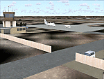
Googly scenery for VAKE Kandla/Gandhidham - a small domestic airport
in the state of Gujurat, India, for which little other than a runway is
provided in Flight Simulator 2004. These scenery files add taxiways, aprons,
buildings and other airport features, so that you and your "AI" traffic can
land, taxi, park and take off in a realistic manner.
Gandhidham is a small city about 5 miles from the seaport of Kandla, in the
Gulf of Kutch, and was developed in 1950 after the separation of Pakistan and
India left the key port of Karachi in Pakistan. The airport is served by daily
flights using turboprop aircraft of Air Deccan.
The scenery does not purport to be ultra-accurate. Based on high-detail satellite
imagery from Google Earth, the layout is proportionally correct but the added
airport features, such as buildings, are built from default Microsoft objects
and add-on libraries so will not look exactly like the real thing.
You are not obliged to download and install any additional scenery libraries,
but to enjoy this scenery in its entirety, you may wish to. It will work fine,
with or without.
[File re-uploaded at request of AVSIM]
| Filename: | VAKE_KandlaGandhidham_India.zip |
| License: | Freeware |
| Added: | 14th May 2010, 05:11:31 |
| Downloads: | 848 |
| Author: | John Hinson |
| Size: | 67.36 KB |


© 2001-2026 AVSIM Online
All Rights Reserved
Privacy Policy |