
Where Flight Simulation Enthusiasts Gather from Around the World!
AVSIM Library - Search Results

| Category: Flight Simulator X - Aircraft Repaints, Textures and Modifications | |
| "Polished RAF Harvard" North American AT-6 (D-FRCP) |

|
Images related to this file:
File Description:
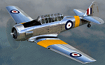
This is a repaint for the payware A2A Simulations AT-6 Texan. This repaint depicts the restored Noorduyn-built Harvard Mk.IIb registered as D-FRCP. An earlier, pre-2010 depiction of this aircraft is included in the A2A product, and this repaint depicts the aircraft as it now appears following an extensive 3-4 year restoration by MeierMotors, completed in 2014. This particular aircraft was assigned to the RCAF during WWII, as FS728, and was later sold to the Netherlands AF in 1947 where it was coded B-104. The aircraft was first sold into the civilian market in 1970, becoming PH-SKL in the Netherlands, and would later be sold to Britain as G-BAFM, then to Switzerland as HB-RCP, and finally to Germany in 2001, becoming D-FRCP. Following its recent restoration, the aircraft is finished in overall polished metal with basic RAF trainer markings.
| Filename: | Polished_RAF_Harvard_North_American_AT6_DFRCP.zip |
| License: | Freeware |
| Added: | 5th June 2016, 12:17:19 |
| Downloads: | 420 |
| Author: | John Terrell |
| Size: | 46.14 MB |
| Category: Flight Simulator 2004 - Scenery | |
| Alexandria Airport N85 |
|
File Description:
FS2004 Scenery - Alexandria Airport (N85) serves Pittstown and Hunterdon County in New Jersey and is owned by Leah Fritsche. The airport has more than one runway. The longest is a paved runway extending 2550 feet. The facility is at an elevation of 480 feet at a distance of about 2 miles from Pittstown. Alexandria Field is home to over 100 planes, and has an active flight school and maintenance shop. Created with EZ Scenery. EZ Scenery libraries required.
| Filename: | Alexandria_Airport_N85.zip |
| License: | Freeware, limited distribution |
| Added: | 17th June 2007, 23:39:52 |
| Downloads: | 692 |
| Author: | John B. Loney, Jr. |
| Size: | 943.55 KB |
| Category: Flight Simulator 2004 - Scenery | |
| Mobile Bay Ft. Morgan |
|
File Description:
This scenery adds Fort Morgan at the entrance of Mobile Bay. It is designed around the FreeFlow Florida scenery and you should get this as it adds the bridge to Dauphin Island and the long bridges across the bay at Mobile. You should also get my Dauphin Island scenery which adds Fort Gaines directly across from Fort Morgan, and if you get my Mobile Bay Lighthouses you will have the Sand Island lighthouse at the entrance to the bay.
| Filename: | Mobile_Bay_Ft_Morgan.zip |
| License: | Freeware |
| Added: | 7th August 2005, 23:35:15 |
| Downloads: | 1,734 |
| Author: | John L. Woodward |
| Size: | 300.88 KB |
| Category: Flight Simulator X - Scenery | |
| Agropoli and Paestum - Italy |
|
File Description:
The FSX filmmakers did not take into consideration the Italian cities,
Therefore, I decided to make some Italian cities such as the city of Agropoli and the ancient city of Paestum, with its ancient monuments.
This scenario is an important VFR reference point on the Tyrrhenian coast.
In the package you'll find four Agropoli.zip file.bgl files that will be placed in
addon scenery folder and sub-folder of FSX scenery to the scenery will be automatically installed.
| Filename: | Agropoli_and_Paestum__Italy.zip |
| License: | Freeware |
| Added: | 27th June 2016, 08:10:59 |
| Downloads: | 676 |
| Author: | Pasquale Marrulli |
| Size: | 4.68 KB |
| Category: Navigation and ATC - Navigation | |
| LSZS - Samedan visual approach chart v3 |
|
Images related to this file:
File Description:
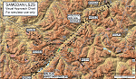
Custom made visual approach chart and pilot's briefing for Engadin (St. Moritz) Samedan LSZS airport in Switzerland, Europe's highest elevation airport (5,600 ft.) situated in the Swiss Alps. This airport is a day VFR operations only and has no instrument approach due to extreme terrain around it. A demanding visual descent into a canyon, in between steep rising terrain, is required to make the visual approaches for both runways with a steep 4.4* degrees final approach portion guided by the PAPI's. Still, executive jets up to Boeing 737(BBJ) size approach the airport often in the winter peak season VFR with these procedures. It is designed as per real operators' pilot briefing for Samedan. Real airport's full pilot briefing document also included. The real airport's excellent briefing (included) intentionally does not contain the maneuvers needed for the approach of jets through the mountains but only reporting points for all and maneuvers for light aircraft only. This gap is what this chart covers. Version 2 chart included better graphics and refined visual procedure for jets and version 3 now includes real pilot's briefing guide.
| Filename: | LSZS__Samedan_visual_approach_chart_v3.zip |
| License: | Freeware, limited distribution |
| Added: | 20th March 2015, 23:35:11 |
| Downloads: | 2,026 |
| Author: | Kyprianos Biris |
| Size: | 7.1 MB |
| Category: Flight Simulator 2004 - Scenery | |
| Julius Nyerere International Airport (HTDA) V1.1 |
|
Images related to this file:
File Description:
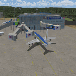
Update to my "julius_nyerere_international_airport_v1" which had some errors in the static objects and other Afcad issues, Delete old version and use this one.
Julius Nyerere International Airport (HTDA) is the largest Airport in Tanzania. It was formerly called Dar-es-salaam International Airport. I used sketchup to build the scenery and ADE v1.70 for the afcad and object positioning.The scenery consists of Terminal 2 (Main International and Domestic terminal) and Terminal 1 which is the old colonial airport now used as the VIP/ General Aviation Domestic Terminal). The scenery utilizes accurate parking positions based on current charts. Hope you enjoy.
| Filename: | Julius_Nyerere_International_Airport_HTDA_V11.zip |
| License: | Freeware |
| Added: | 1st January 2018, 03:11:58 |
| Downloads: | 686 |
| Author: | Emmanuel Mwandosya |
| Size: | 31.76 MB |
| Category: Flight Simulator 2004 - Scenery | |
| EDXN+ETMN Nordholz-Spieka Airfield and Nordholz Navy Airbase |
|
Images related to this file:
File Description:
Because so many of you asked, I reworked my former Nordholz Navy Airbase Scenery.
This is the new Nordholz-Spieka (EDXN) Scenery with the moved Runway while the Navy expand its area.
The Scenery part with the Nordholz Navy Airbase is totaly reworked. All Hangars are now like the real ones, taxi signs have been placed, ground textures are placed around the airfields and as a special gift to you, I added a small traffic pack to this package.
It contains the traffic for the Brequet Atlantic and Helicopters at Northwood Airbase. Enjoy it!
| Filename: | EDXNETMN_NordholzSpieka_Airfield_and_Nordholz_Navy.zip |
| License: | Freeware |
| Added: | 9th July 2014, 17:07:24 |
| Downloads: | 1,067 |
| Author: | David Kolas |
| Size: | 14.13 MB |
| Category: Flight Simulator 2002 - Scenery | |
| Maine1, Version 2 Enhanced |
|
File Description:
Like flying low and slow in 150's and Cubs? Like seaplanes? Amphibians? Helicopters? Then this scenery is for YOU! The eagerly awaited Maine scenery area covering the coastal islands near Bar Harbor will immerse you in a rare flight simulator experience. Eight wonderful small airports from concrete to dirt, helicopter and seaplane landable lighthouses, seaplane asscessable marinas, and detailed towns as well as small boats float past beneath your wings. Full sound at all landable areas! Requires Lagos FSSE (scenery), FSSS (sound), and FSGenesis US Landclass (places the towns in the correct spot) freeware or payware version. Youre gonna love this one!
| Filename: | Maine1_Version_2_Enhanced.zip |
| License: | Freeware, limited distribution |
| Added: | 12th April 2003, 00:01:53 |
| Downloads: | 1,736 |
| Author: | Tom Constantine and Lauren Robison |
| Size: | 3.57 MB |
| Category: Flight Simulator 2004 - Scenery | |
| Camarillo Airport KCMA |
|
File Description:
FS2004 Scenery - Camarillo Airport (ICAO: KCMA, FAA LID: CMA) is a public airport located three miles (5 km) west of the central business district (CBD) of Camarillo, in Ventura County, California, USA. It is roughly equidistant from Los Angeles, CA and Santa Barbara, CA although it is inland. The airport has one runway and exclusively serves privately-operated general aviation and executive aircraft with no scheduled commercial service. The paved runway extends for 6010 feet. The facility is at an elevation of 75 feet. Created with EZ Scenery. EZ Scenery libraries required. Please read the readme file. By John B. Loney, Jr.
| Filename: | Camarillo_Airport_KCMA.zip |
| License: | Freeware, limited distribution |
| Added: | 15th May 2007, 00:11:49 |
| Downloads: | 2,418 |
| Author: | John B. Loney, Jr. |
| Size: | 5.1 MB |
| Category: Flight Simulator 2004 - Scenery Design | |
| "Crosshairs_Plus" Panel & Model Enhancement Package |
|
File Description:
This is a panel & model enhancement package for the popular FinneyGround Crosshairs_Plus scenery placement tool (chplus.zip), by Gary Mills, Robert Finnegan, and Kevin Bryan (FinneyGround). This package adds a "panel" with a highly accurate XML "Scenery Placement Gauge". Also included is an additional Gmax model, considerably smaller in size and graduated in feet rather than meters. In addition to being an extremely accurate scenery placement tool, this aircraft is an absolute hoot to fly! A minimal 2D panel .bmp aids visual reference from the cockpit while flying the model. Requires "chplus.zip", also available here at Avsim.
| Filename: | Crosshairs_Plus_Panel__Model_Enhancement_Package.zip |
| License: | Freeware, limited distribution |
| Added: | 30th August 2007, 18:01:23 |
| Downloads: | 3,611 |
| Author: | Jim Robinson / FinneyGround |
| Size: | 149.61 KB |


© 2001-2026 AVSIM Online
All Rights Reserved
Privacy Policy |