
Where Flight Simulation Enthusiasts Gather from Around the World!
AVSIM Library - Search Results

| Category: Flight Simulator X - Aircraft Repaints, Textures and Modifications | |
| "Polished RAF Harvard" North American AT-6 (D-FRCP) |

|
Images related to this file:
File Description:
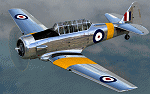
This is a repaint for the payware A2A Simulations AT-6 Texan. This repaint depicts the restored Noorduyn-built Harvard Mk.IIb registered as D-FRCP. An earlier, pre-2010 depiction of this aircraft is included in the A2A product, and this repaint depicts the aircraft as it now appears following an extensive 3-4 year restoration by MeierMotors, completed in 2014. This particular aircraft was assigned to the RCAF during WWII, as FS728, and was later sold to the Netherlands AF in 1947 where it was coded B-104. The aircraft was first sold into the civilian market in 1970, becoming PH-SKL in the Netherlands, and would later be sold to Britain as G-BAFM, then to Switzerland as HB-RCP, and finally to Germany in 2001, becoming D-FRCP. Following its recent restoration, the aircraft is finished in overall polished metal with basic RAF trainer markings.
| Filename: | Polished_RAF_Harvard_North_American_AT6_DFRCP.zip |
| License: | Freeware |
| Added: | 5th June 2016, 12:17:19 |
| Downloads: | 420 |
| Author: | John Terrell |
| Size: | 46.14 MB |
| Category: Flight Simulator X - AFCAD Files | |
| FSX North Korea DMZ, UGF and Ballistic Missile Base Addon Scenery Package |
|
Images related to this file:
File Description:

I titled this a "DMZ, UGF and Ballistic Missile Base" scenery package because that's how this whole project started, but then it SNOWBALLED onto 80+ scenery areas for ALL of North Korea!
This package includes scenery AFCADs for 2 DMZ "Border Wall Areas", 8 DMZ SAM/EW radar sites (TacPack users can "spawn" SA-2s there!), 5 "secret" ballistic missile bases, two "secret" UnderGround Facility (UGF) locations like "TOPGUN 2", 5 navy bases/dockyards along the east coast, 2 nuclear facilities, 2 machine factories, and an Oil Refinery.
BUT WAIT! For the city of Pyongyang I added the Pyongyang Thermal Power Plant, the Pyongyang-Dong Power Plant, 2 power grid "sub stations" with SA-6 SAM sites, the Pyongyang rail yard, and the "VIP Airport" on the SE side of the city.
THERES MORE! (somebody STOP me!) I also did 23 fighter bases along with 12 helicopter bases (grass strips), and ALL of the fighter & helicopter bases have active runways, taxiways, and plenty of "Mil_Combat" parking available for AI aircraft.
For those who like "Carrier Ops", I put 4 "Naval Waypoints" off the coast of N Korea...2 in the Yellow Sea and 2 in the Sea of Japan. ALL FOUR have static aircraft carriers at their locations, or you can spawn/start an AI Carrier there instead!
Installation is SUPER easy and I've included instructions to install this SUPER-SIZED package as a stand-alone "Scenery Area" in your FSX Scenery Library. That way you can just click it on or off as needed, instead of clogging up your "Addon Scenery/Scenery" file with 200+ AFCAD files!
| Filename: | FSX_North_Korea_DMZ_UGF_and_Ballistic_Missile_Base.zip |
| License: | Freeware |
| Added: | 14th March 2024, 00:59:31 |
| Downloads: | 153 |
| Author: | Daniel Gregory |
| Size: | 22.5 MB |
| Category: Navigation and ATC - Navigation | |
| LSZS - Samedan visual approach chart v3 |
|
Images related to this file:
File Description:
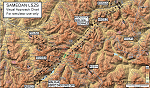
Custom made visual approach chart and pilot's briefing for Engadin (St. Moritz) Samedan LSZS airport in Switzerland, Europe's highest elevation airport (5,600 ft.) situated in the Swiss Alps. This airport is a day VFR operations only and has no instrument approach due to extreme terrain around it. A demanding visual descent into a canyon, in between steep rising terrain, is required to make the visual approaches for both runways with a steep 4.4* degrees final approach portion guided by the PAPI's. Still, executive jets up to Boeing 737(BBJ) size approach the airport often in the winter peak season VFR with these procedures. It is designed as per real operators' pilot briefing for Samedan. Real airport's full pilot briefing document also included. The real airport's excellent briefing (included) intentionally does not contain the maneuvers needed for the approach of jets through the mountains but only reporting points for all and maneuvers for light aircraft only. This gap is what this chart covers. Version 2 chart included better graphics and refined visual procedure for jets and version 3 now includes real pilot's briefing guide.
| Filename: | LSZS__Samedan_visual_approach_chart_v3.zip |
| License: | Freeware, limited distribution |
| Added: | 20th March 2015, 23:35:11 |
| Downloads: | 2,026 |
| Author: | Kyprianos Biris |
| Size: | 7.1 MB |
| Category: Flight Simulator 2004 - Utilities | |
| LJSceneGen V 1.0 |
|
File Description: LJSceneGen is a scenery creation utility for the Microsoft (MS) Flight Simulator FS9 (aka FS2004 or Century of Flight). The program presents a series of forms where various options for VORs, NDBs, Exclusion Rectangles, Markers, Waypoints and Scenery Library objects can be entered. The program will try to connect FS9 via FSUIPC or WideFS. If a FSUIPC connection is found, the location (Lat. Long. and Alt and others if available and appropriate) will be automatically retrieved. You can also move the aircraft to a new location by entering a Lat. and Long. pair and clicking "Move Aircraft". Multiple combinations VORs, NDBs, Exclusion Rectangles, Markers, Waypoints and Scenery Library objects can be saved and each saved object can be edited. After all the desired objects are created, an XML file can be created. This file can be submitted to the FS2004 SDK BGL compiler "BGLCOMP.exe". A file with an extension of .BGL will result which you then place in your Addon Scenery/scenery/ folder to view your just created scenery object(s) after you restart FS9. This or other properly formulated .XML scenery files can be imported and reviewed. For example, the FS9 file NVNAMC0.bgl can be decompiled, imported into LJSceneGen and then viewed. Alessandro Antonini's excellent BGLXMLdecompiler program makes possible the conversion from NVNAMC0.bgl. to NVNAMC0.xml which can then be read by LJSceneGen. (This file is available at Alec's site: http://www.cpinf.net ). Each VOR and NDB found in this decompiled xml file can be reviewed and if you want, you can move your aircraft to the object's location by clicking "Move Aircraft". This program is written in MS's C# language using .NET framework 1.1. The CLR .NET Framework 1.1 must be installed on your computer before the program will run. The freeware version of Pete Dowson's FSUIPC is not supported. Users should be very familar with the FS2004 scenery SDK. This version only knows VORs, NDBs, Exclusion Rectangles, Markers, Waypoints, and Scenery Library objects. It doesn't yet know about Airports Runways ILSes etc. This is not a "What You See Is What You Get" program but instead takes a semi-automated fill-in-the-blanks approach. The program is a scenery creation utility. As such, inexperienced scenery designers may not find it user friendly.
| Filename: | LJSceneGen_V_10.zip |
| License: | Freeware, limited distribution |
| Added: | 14th March 2004, 01:10:12 |
| Downloads: | 2,411 |
| Author: | Larry Jones |
| Size: | 469.34 KB |
| Category: Flight Simulator 2004 - Scenery | |
| Multinational Force and Observers |
|
Images related to this file:
File Description:
This project brings to life the Multinational Force and Observers North Camp at El Gorah AB (HEGR) and South Camp near Sharm El-Sheikh. Included are scenery for both camps, FS9 tested flight plans as well as FS9 and FSX repaints for the UH-60s of the US Army Task Force Sinai 1st Support Battalion using John Youngs AI UH-60. Please see the readme file for a list of required scenery libraries.
| Filename: | Multinational_Force_and_Observers.zip |
| License: | Freeware |
| Added: | 1st October 2015, 08:36:28 |
| Downloads: | 315 |
| Author: | Brent Newman |
| Size: | 4.79 MB |
| Category: Flight Simulator 2002 - AFCAD Files | |
| MMMX Mexico City Gates |
|
File Description:
This file is for special use with MEXICO.ZIP by Bil Melichar, but also works on default scenery, adds room for: ¡35 small gates, 8 heavy gates, 9 medium gates, 3 cargo ramps and 12 parking spots for GA!. This allows you to add AI Traffic using any aircraft of your choice!. Suggested and comments are welcome. It's part of a proyect to modify All the GATES in mexican airports of FS2002 default scenery.
| Filename: | MMMX_Mexico_City_Gates.zip |
| License: | Freeware |
| Added: | 22nd October 2002, 10:57:34 |
| Downloads: | 869 |
| Author: | Ricardo Colín Bárcena |
| Size: | 11.6 KB |
| Category: Flight Simulator 2004 - AFCAD Files | |
| Fly Tampa - San Fransisco (KSFO) + Crossing Runways |
|
File Description:
This is a modded version of the default AFCAD 2 file that came with Flytampa San Fransisco Intl. scenery (KSFO).
This also includes the use of crossing Runways using the "STAR" method. Runways 28L, 28R, 19L & 19R for landing. Runways 28L, 28R & 19R for takeoff. Most Gates and Taxiways are pretty accurate. I hope You enjoy... Keep an eye out for my future KEWR (simflyers) and KBOS (the wonderful George Grimshaw scenery)...
| Filename: | Fly_Tampa__San_Fransisco_KSFO__Crossing_Runways.zip |
| License: | Freeware |
| Added: | 9th November 2004, 13:55:26 |
| Downloads: | 4,983 |
| Author: | Roberto Messina |
| Size: | 14.69 KB |
| Category: Flight Simulator 2004 - Scenery | |
| UGGT Erekle II Airport "Mimino", Telavi, Georgia |
|
File Description:
This is a light scenery of UGGT Erekle II "Mimino" Airport in Telavi, Kakheti Province, Republic of Georgia. It is basically the FSX/P3D UGGT Telavi scenery by Georgian Virtual Airports/David Hilker, converted and modified for MSFS2004 aka FS9 by me with the author's permission. See included readme file for more information. This new version includes a fix for some users who experienced doubled runways and/or artefacts at the runway.
| Filename: | UGGT_Erekle_II_Airport_Mimino_Telavi_Georgia.zip |
| License: | Freeware, limited distribution |
| Added: | 27th January 2018, 01:33:50 |
| Downloads: | 402 |
| Author: | Harald Geyer |
| Size: | 7.02 MB |
| Category: Flight Simulator 2004 - Scenery | |
| Cameri and Turbigo sceneries (rev. 3) - north Italy |
|
Images related to this file:
File Description:
The following files are required by this file:
http://library.avsim.net/esearch.php?DLID=163723&UploadID=&Name=&FileName=&Author=&CatID=root
http://library.avsim.net/esearch.php?DLID=186350&UploadID=&Name=&FileName=&Author=&CatID=root
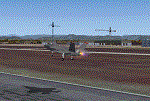
This scenery includes a global review of the previous Sceneries of Cameri Military airport (rev.2 Oct 2011), Cameri Museum (rev. 2 Oct 2011), Cameri Babini (rev. 2 oct 2011), Turbigo power station (rev. 2 Sep 2011 and update rev. 2.1 Oct 2014). All the above ARE NOW INCLUDED in this new unique scenery. Contents: Terrain in new version photo-realistic multi-seasons/night; adapted to Western Europe special elevation meshes; cover area of over 120 sqkm from Bellinzago-Oleggio (NW) to Magnago-Bienate (NE), from Novara (SW) to Cuggiono-Inveruno (SE); all the terrain has been restorated with 3D buildings, either through autogen that with specific dedicated objects (by GMax) and with significant addition of library objects ("dva51" and other existings). This scenery (located on the final approach to the Milan Malpensa international airport) includes the Cameri's Mil Airport with the Babini closed Army area and the planes of the Historical Museum of the airport; it is also included the thermoelectric power station of Turbigo. All the buildings are placed to recreate cities and villages covered in the photo-realistic terrain, including Bellinzago, Bienate, Buscate, Caltignaga, Cameri, Castano Primo, Castelletto Ticino, Cuggiono, Galliate, Inveruno, Magnago, Malvaglio, Nibbia, Novara, Oleggio, Pernate, Robecchetto, Romentino, Sant'Anna, San Pietro Mosezzo, Turbigo , Vanzaghello, and the covered Turin-Milan highway.
Details of the new buildings for the care and maintenance to F35 completely recreated, as obtainable from the current satellite view.
It REQUIRES the use of the following, to be downloaded separately :
- the libraries dva51 - the system of vegetations TreePlanter - the West Europe Meshes of Daniele Lanfranchi. See the Readme file. Enjoy!
Videos available here:
https://dl.dropboxusercontent.com/u/38829151/FS9/Cameri_Turbigo_v3%20shots.WMV
http://youtu.be/yVI2KeJKS5o
http://youtu.be/oKa0e_5kxIk
| Filename: | Cameri_and_Turbigo_sceneries_rev_3__north_Italy.zip |
| License: | Freeware |
| Added: | 21st January 2015, 21:32:36 |
| Downloads: | 995 |
| Author: | Aldo Della Vedova, Daniele Lanfranchi and Gian Mario Verga |
| Size: | 103.7 MB |
| Category: X-Plane - Scenery | |
| BR GO - SBGO Goiania v1.1.0 |
|
Images related to this file:
File Description:
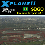
SBGO v1.1.0 - This is an X-Plane 11 and X-Plane 10 scenery package for Santa Genoveva/Goiânia Airport (IATA: GYN, ICAO: SBGO), in Goiania, GO, central area of Brazil. It includes corrected aprons, ramps, taxiways, the new terminal (2016), lighting system, city buildings, ortho-photo scenery for the airfield area, and (XP11 only) ground services (like push back) for SBGO/GYN airport. This scenery was tested and is operational (as of March 08, 2017) in "X-Plane 11 Public Beta #13 64 bit", Windows 10 Home. It was also tested is operational (as of March 08, 2017) in "X-Plane 10.51 64 bit", Windows 10 Home. Only the default X-Plane 11 libraries, by Laminar Research, are needed. No third party libraries are used. v1.1.0 adds the city buildings to Goiania, adds orthophoto scenery for the airfield area, and it is now also compatible with both XP 10.51 and XP11.
| Filename: | BR_GO__SBGO_Goiania_v110.zip |
| License: | Freeware |
| Added: | 9th March 2017, 04:46:47 |
| Downloads: | 122 |
| Author: | Rui Mesquita |
| Size: | 13.35 MB |


© 2001-2026 AVSIM Online
All Rights Reserved
Privacy Policy |