
Where Flight Simulation Enthusiasts Gather from Around the World!
AVSIM Library - Search Results

| Category: Flight Simulator 2004 - Scenery | |
| Brevoort CWOB and BAF-3 radar plus Cartwright LAB-6 radar Canada |

|
Images related to this file:
File Description:
Brevoort airstrip and the BAF-3 radar it serves is on Brevoort Island, off one of the southeastern tips of Baffin Island and 140 miles east of Iqaluit. This scenery includes the BAF-3 buildings on the hilltop and those on the airstrip below, plus the roads connecting them and down to the beach landing area on the rocky coast. This scenery is made for the FSGenesis 76m terrain mesh for northern Canada, and there will be a repost of all my northern Canada airfields to suit this; I cannot think now why I never installed this mesh before. The AI reflects the use of civil airlines for resupply and transportation of personnel. Given the terrain the wind should be from the north so that ai lands using the 02 runway. Landing from the north will involve a terrain clash while take off towards the north will not as the climb out clears the hilltop. The video shows the 600 foot cliff at the runway threshold and an Air Tindi plane on the apron. Cartwright CYCA is on the Labrador coast and has been posted by Flight Ontario as part of their Goose Bay and Labrador Regional Airports sceneries. The nearby LAB-6 radar site is included here, connected to CYCA by an extended road. The site uses the same buildings as Brevoort and Saglek (posted recently) and although I have included them here as separate sceneries the contents can be placed in the same folders as Saglek with a saving in duplicated textures. The textures here are more accurate than Saglek so say yes to over-write; a downloader with personal experience of Brevoort noted that in reality they are lighter.
| Filename: | Brevoort_CWOB_and_BAF3_radar_plus_Cartwright_LAB6_.zip |
| License: | Freeware, limited distribution |
| Added: | 20th August 2017, 15:46:36 |
| Downloads: | 175 |
| Author: | Roger Wensley |
| Size: | 4.37 MB |
| Category: Flight Simulator 2004 - Scenery | |
| Glacier Bay - Alaska/Canada, Version 2, Part 1 of 2 |
|
Images related to this file:
File Description:
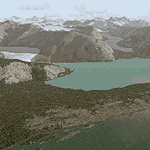
Glacier Bay v2 is a complete replacement of the default FS2004 landscape and scenery of more than 90,000 square kilometers (36,000 sq miles) of Southeast Alaska and adjacent areas of Yukon and British Columbia. File 1 of 2 (also requires glbayv2b.zip)
Landscape enhancements include high-resolution terrain mesh, detailed shorelines, rivers, lakes, and glaciers, and accurate land cover data with custom seasonal ground textures. Inland water bodies can be made to "freeze over" via an on/off switch. Other landmarks include the settlements of Juneau, Haines, Skagway, Yakutat, Atlin, and Carcross as well as road and railroad networks, cabins, lodges, and lighthouses. We modeled or enhanced 16 main airfields (plus one fictitious airstrip), 20 unlisted airstrips, 16 seaplane bases, and seven heliports. We've also included AI ship traffic in various locations as well as optional flightplans for GA and floatplane AI traffic.
Glacier Bay v2 is fully compatible with other third-party add-ons, including terrain mesh (FSGlobal, FS Genesis, etc.), ground textures (Ground Environment, BEV, FScene, etc.), and landscape enhancements (Ultimate Terrain Canada/Alaska, Misty Fjords, Tongass Fjords, Freight Dogs). A configurator panel (requires .Net Framework!) allows users to set compatibility options and to choose levels of scenery detail. We provide an autoinstaller and detailed documentation with a sectional map of the coverage area and a list of weblinks to real-world information.
For feedback and questions, please visit the Glacier Bay v2 support forum at http://forums.fsaddon.eu/viewforum.php?f=10. This project is a collaboration of nine FS developers from Germany, Austria, USA, and Canada, logging more than 1000 hours of work over the past 14 months. We acknowledge the kind support of FSAddon.com. However, this project is independent of any commercial company or product. Enjoy!
| Filename: | Glacier_Bay__AlaskaCanada_Version_2_Part_1_of_2.zip |
| License: | Freeware, limited distribution |
| Added: | 28th May 2010, 19:34:54 |
| Downloads: | 41,280 |
| Author: | Holger Sandmann, Rainer Duda, Michael Eder, Scot Fraser, Manfred Herz, Jay Langham, Jon Patch, Larry Silsbee, and Jim Vile |
| Size: | 56.46 MB |
| Category: Flight Simulator 2004 - Scenery | |
| Glacier Bay - Alaska/Canada, Version 2, Part 2 of 2 |
|
Images related to this file:
File Description:

Glacier Bay v2 is a complete replacement of the default FS2004 landscape and scenery of more than 90,000 square kilometers (36,000 sq miles) of Southeast Alaska and adjacent areas of Yukon and British Columbia. File 2 of 2 (also requires glbayv2a.zip)
Landscape enhancements include high-resolution terrain mesh, detailed shorelines, rivers, lakes, and glaciers, and accurate land cover data with custom seasonal ground textures. Inland water bodies can be made to "freeze over" via an on/off switch. Other landmarks include the settlements of Juneau, Haines, Skagway, Yakutat, Atlin, and Carcross as well as road and railroad networks, cabins, lodges, and lighthouses. We modeled or enhanced 16 main airfields (plus one fictitious airstrip), 20 unlisted airstrips, 16 seaplane bases, and seven heliports. We've also included AI ship traffic in various locations as well as optional flightplans for GA and floatplane AI traffic.
Glacier Bay v2 is fully compatible with other third-party add-ons, including terrain mesh (FSGlobal, FS Genesis, etc.), ground textures (Ground Environment, BEV, FScene, etc.), and landscape enhancements (Ultimate Terrain Canada/Alaska, Misty Fjords, Tongass Fjords, Freight Dogs). A configurator panel (requires .Net Framework!) allows users to set compatibility options and to choose levels of scenery detail. We provide an autoinstaller and detailed documentation with a sectional map of the coverage area and a list of weblinks to real-world information.
For feedback and questions, please visit the Glacier Bay v2 support forum at http://forums.fsaddon.eu/viewforum.php?f=10. This project is a collaboration of nine FS developers from Germany, Austria, USA, and Canada, logging more than 1000 hours of work over the past 14 months. We acknowledge the kind support of FSAddon.com. However, this project is independent of any commercial company or product. Enjoy!
| Filename: | Glacier_Bay__AlaskaCanada_Version_2_Part_2_of_2.zip |
| License: | Freeware, limited distribution |
| Added: | 28th May 2010, 19:36:31 |
| Downloads: | 40,552 |
| Author: | Holger Sandmann, Rainer Duda, Michael Eder, Scot Fraser, Manfred Herz, Jay Langham, Jon Patch, Larry Silsbee, and Jim Vile |
| Size: | 85.99 MB |
| Category: Flight Simulator X - AFCAD Files | |
| LYKI - Kikinda airport - Kikinda, Serbia |
|
File Description:
Kikinda Airport (Serbian: Aerodrom Kikinda) is a domestic airport in Serbia, situated in the vicinity of the northern town of Kikinda (9 kilometres south-west from the town centre), close to the Subotica-Novi Sad route.
It is used mainly for sports flights of aircraft, gliders; helicopter flights and parachute jumps. VFR charts included
| Filename: | LYKI__Kikinda_airport__Kikinda_Serbia.zip |
| License: | Freeware |
| Added: | 1st June 2016, 16:19:37 |
| Downloads: | 171 |
| Author: | Danilo Jankovic |
| Size: | 217.29 KB |
| Category: Flight Simulator 2004 - AI Flight Plans | |
| Atlasjet (Turkey) Winter 09-10 |
|
Images related to this file:
File Description:

Atlasjet are a private carrier from Turkey flying with a small number of A320/A321 aircraft to domestic points as well as to international destinations. This work depicts Atlasjet's scheduled only operations out of their Istanbul and Ercan (Northern Cyprus) bases. Data taken from OAG and compiled with MRAIgen for easy installation with MRAIinstall wizard.
| Filename: | Atlasjet_Turkey_Winter_0910.zip |
| License: | Freeware |
| Added: | 24th January 2010, 21:57:42 |
| Downloads: | 929 |
| Author: | Dimitri Tousmanof |
| Size: | 5.63 KB |
| Category: Flight Simulator 2004 - Scenery | |
| Matarangi Beach Airfield, New Zealand. NZAG. |
|
File Description:
Welcome to Matarangi Beach, located 1 nautical mile east of Whangapoua Harbour, in the northern Coromandel area of the east coast of the North Island of New Zealand.
Matarangi Beach is another of the east coast's popular and fast growing beach resorts. Scenery requires some EZ Scenery Object Sets (see INSTALL instructions for details).
| Filename: | Matarangi_Beach_Airfield_New_Zealand__NZAG.zip |
| License: | Freeware, limited distribution |
| Added: | 2nd January 2009, 22:49:04 |
| Downloads: | 601 |
| Author: | Lawrie Roache |
| Size: | 1.54 MB |
| Category: Flight Simulator 2004 - Original Aircraft | |
| Short Sunderland MkIII |
|
File Description:
Short Sunderland Mk III for FS2004 only
MkIII, NJ188. RAF Coastal Command No. 228 Squadron
Multi res model made by Stuart Green using FSDSv2. Airfile by James Banks
Usual animated surfaces (no gear!), plus animated doors and armament.
| Filename: | Short_Sunderland_MkIII.zip |
| License: | Freeware |
| Added: | 26th December 2003, 04:29:33 |
| Downloads: | 7,372 |
| Author: | Stuart Green |
| Size: | 2.2 MB |
| Category: Flight Simulator X - AFCAD Files | |
| MDLR - La Romana International Airport / Casa de Campo/La Romana, Dominican Republic |
|
Images related to this file:
File Description:
MDLR - La Romana International Airport / Casa de Campo/La Romana, Dominican Republic
This airport update was made with the latest version of ADE (Airport Design Editor) and made for FSX as a replacement for the stock (default) airport. I found that most stock airports in FSX lack a decent amount of character and realism and this area in particular was dreadful! The stock airport was rather inaccurate. I've made several additions to the airport which are listed below. All these enchancements are as close to the real airport as I can get with stock library objects. I've used satellite images, terminal photos and maps throughout the whole process so building locations are as accurate as possible. Happy landings in the Dominican Republic!
Features:
*Expanded parking apron with 6 gates for commercial traffic
*Seperate parking aprons for GA traffic
*Main terminal building
*Hangar and other airport buildings added
*Airport vehicles and objects throughout the airport
*Birds near the airport
*Main road in front of airport added with static vehicles
*Parking lots with static vehicles
*Vegetation in front of airport
| Filename: | MDLR__La_Romana_International_Airport__Casa_de_Cam.zip |
| License: | Freeware |
| Added: | 18th July 2012, 06:13:46 |
| Downloads: | 594 |
| Author: | Jaison Diaz |
| Size: | 6.72 KB |
| Category: Flight Simulator X - Scenery | |
| Willapa Harbor Airport (2S9) |
|
File Description:
Willapa Harbor, animated characters, used satellite imagery for building placement. By David Abreu.
| Filename: | Willapa_Harbor_Airport_2S9.zip |
| License: | Freeware |
| Added: | 23rd December 2011, 11:36:05 |
| Downloads: | 384 |
| Author: | David Abreu |
| Size: | 3.7 KB |
| Category: Flight Simulator X - Original Aircraft | |
| BSG Colonial 1 - Rev 2 |
|
File Description:
FSX: BSG Colonial1 - Rev 2. Revision 2 additions 05/03/07. Static VC and lighted cabin with crew (cockpit light key), animated gear, animated Engine Cowls (retracts with gear), exterior logo lighting for night ops (strobes key). For FSX/FS9 by Bruce Fitzgerald
| Filename: | BSG_Colonial_1__Rev_2.zip |
| License: | Freeware |
| Added: | 4th May 2007, 14:50:22 |
| Downloads: | 3,007 |
| Author: | Bruce Fitzgerald |
| Size: | 3.33 MB |
© 2001-2026 AVSIM Online
All Rights Reserved
Privacy Policy |