
Where Flight Simulation Enthusiasts Gather from Around the World!
AVSIM Library - Search Results

| Category: Flight Simulator 2004 - Scenery | |
| Beaver Creek CYXQ in Yukon Territory, Canada |

|
Images related to this file:
File Description:
Beaver Creek is located at mile 1202 of the Alaska Highway, just east of the Alaska/Yukon border. The populaton is around 100 and the main employment is with the Border Agency, the White River First Nation, or with local tourist lodges. The airfield is a mile north of the town and close to the Canadian border post, which is included in the scenery. It was built by Jack Stalberg in the 1960's, and I have no further information beyond the fact that he loved to fly. The airport serves as an "airport of entry", though it is restricted in hours of opening and in the size of aircraft that it can handle; up to a maximum of only 15 seats. The single runway is 3,745 feet long and 100 feet wide, gravel, aligned 13-31 in FS9, lit, and with vasi at both ends. Righthand circuits for runway 13. There is a 340 feet threshold displacement to runway 31, which is of course unmarked on a gravel runway. The terminal building was recently reclad; I don't like it, but they didn't consult me. The ai reflects the sort of traffic the airfield gets; ie brief paperwork stopovers for GA or small charter flights into Canada from Alaska, usually in the mornings.I have adjusted the local scenery terrain levels to remove adjacent hills that I believe do not exist in real life but are part of the Northern Canada terrain mesh that I have installed. If you do not have this mesh you may find that the scenery works fine for you without the API flatten that is included here. The airfield is at 2,129 feet ASL.
| Filename: | Beaver_Creek_CYXQ_in_Yukon_Territory_Canada.zip |
| License: | Freeware, limited distribution |
| Added: | 28th January 2019, 06:19:20 |
| Downloads: | 175 |
| Author: | Roger Wensley |
| Size: | 4.68 MB |
| Category: Flight Simulator 2004 - Scenery | |
| Haines Junction CYHT in Yukon Territory Canada |
|
Images related to this file:
File Description:
Haines Junction is a village in the Yukon Territory, Canada, amid the Rocky Mountains and around 80 miles west of Whitehorse. It is sited at the junction of the Haines Highway and the Alaska Highway, hence the name. The village was established in 1942 when the Alaska Highway was under construction, and the Haines Highway was built over the Chilkat Pass to connect to the town of Haines on the Alaska coast.
The date of this scenery is, as usual, around 2010. At that time there was a regular service (not always a daily one, depending on the time of year) by Yukon Air North, and in this case it is by an ATR 42-300. There is a helicopter company based at the airfield, Trans North Helicopters, and there is also Kluane Glacier Air Tours, which, as the name suggests, takes you to a glacier so you can stroll around on ice. And then brings you back. The gravel runway is 5,000 feet long and aligned 04-22, and is lit, with PAPI at both ends. Right hand circuits are required for runway 04 as the terrain is not flat.
This post will be followed by two other airfields to the northwest, Silver City and Burwash, both of which are on or close to the Alaska Highway.
| Filename: | Haines_Junction_CYHT_in_Yukon_Territory_Canada.zip |
| License: | Freeware, limited distribution |
| Added: | 22nd January 2022, 21:53:16 |
| Downloads: | 118 |
| Author: | Roger Wensley |
| Size: | 20.46 MB |
| Category: Flight Simulator 2004 - Aircraft Repaints, Textures and Modifications | |
| Airbus A321-231 in new house colors |
|
Images related to this file:
File Description:
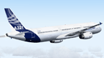
Highly detailed repaint of A321-231 F-WISS in Airbus house colors (fictional). Project Airbus presents the Airbus A321. Features include dynamic wingflex (with input from several new variables), drooping control surfaces, hardcoded double strobes, and over 20 other custom XML parts. Visit www.pairbus.com. Requires Project Airbus A321-231 IAE Model. Textures only. Requires base pack available here at Avsim. Thank you Project Airbus for creating such a beautiful bird. Painting this plane made much fun. Installer read me included.
| Filename: | Airbus_A321231_in_new_house_colors.zip |
| License: | Freeware |
| Added: | 12th June 2011, 08:40:33 |
| Downloads: | 1,341 |
| Author: | Thomas Eisenbach / Project Airbus |
| Size: | 6.13 MB |
| Category: Flight Simulator 2004 - Scenery | |
| Fairbanks International PFAF Float Base in Alaska |
|
Images related to this file:
File Description:
This is the floatplane base which is part of Fairbanks International Airport, PFAF. It has a separate PAFX identifier here due to the limitations of AI in FS9. Though it doesn't come close to the activity level of Lake Hood in Anchorage Alaska it is still a fairly busy place. In Fairbanks there is this floatbase, Chena Marina to the southwest, Chena River to the northwest, and Metro Field to the east between Fairbanks and the river. You will need Ultimate Terrain Alaska Canada, and you must first install the version of Fairbanks International PFAF by William Morgan, as this scenery was the starting point for the floatplane base scenery, and without it the result would be disappointing. There are scenery and land class files, files that modify PFAF, AFCAD for AI, and a traffic file.
| Filename: | Fairbanks_International_PFAF_Float_Base_in_Alaska.zip |
| License: | Freeware, limited distribution |
| Added: | 19th August 2010, 22:55:46 |
| Downloads: | 796 |
| Author: | Roger Wensley |
| Size: | 1.03 MB |
| Category: Flight Simulator 2004 - Scenery | |
| St Andre-Avellin CAA2 in Quebec Canada |
|
Images related to this file:
File Description:
St Andre-Avellin is a new airfield in Quebec Canada, 35 miles east of Ottawa and 10 miles north of the Ottawa River, and just northwest of the village of the same name. There is a 03/21 grass runway that is 2,870 feet long and slopes up towards the north. To show this slope I have not "placed" a grass runway (which would immediately flatten the slope) and anway there is not so much traffic that the grass would be notably marked. Because of the lack of an FS-recognised runway I have not made parking or a traffic file as AI would not work; anyway this airfield with constant activity would not reflect reality. There are no facilities at the airfield except a hangar for the owner and space to park.
| Filename: | St_AndreAvellin_CAA2_in_Quebec_Canada.zip |
| License: | Freeware, limited distribution |
| Added: | 9th April 2011, 20:49:47 |
| Downloads: | 170 |
| Author: | Roger Wensley |
| Size: | 816.9 KB |
| Category: Flight Simulator 2004 - Scenery | |
| Fort Nelson CYYE in British Columbia, Canada |
|
Images related to this file:
File Description:
Fort Nelson is close to the Peace River in the northeast corner of British Columbia, around 70 miles from the northern border, 90 from the eastern border, and 80 miles east of the Rockies. The wartime construction of the Alaska Highway actually started from Fort Nelson, as there was already a road from Fort St John (which is close to Dawson Creek) north to Fort Nelson. The airfield was part of this construction effort and after the wartime ferrying of planes to Russia it was used by the US Army Air Force and then by the Canadian Air Force. Fort Nelson flourished with the oil and gas exploration of the 1950's and the following years, and this continued to grow until the collapse of the oil price in 2014.
The town of Fort Nelson became the capital of the Northern Rockies Regional District when it was founded in 2009, and as a result the official name of the Fort Nelson airport is the Northern Rockies Regional Airport. The date for this scenery is around 2016, by which time the economic fortunes of the town were in decline. Five times per day flights by Central Mountain Air were starting to be reduced in number to the current (in 2022) one per day and none on Sunday; in the AI included here there are two flights per day. The main resident users of the airport are four helicopter companies, the helicopters presumably used for maintenance trips to whatever parts of the oil and gas fields that are still in use in the surrounding area.
There are two runways, the main one is aligned 03-21, 6,400 feet long and 200 feet wide, with ILS at the southern end and PAPI at the northern. The second runway (a narrower rebuild on a previously existing runway) is aligned 07-25 and 77 feet wide, and is without any lights. These are the alignments as per the original build of FS9 and not as per the approximate 2016 date of the buildings; I had a problem at a very late stage in making this scenery which prevented me from continuing with some final details.
On YouTube there is a series of posts by Angle of Attack showing the preparation and then the flight of an old Cessna 172 from Homer to Oshkosh for the installation of modern instruments. Interesting for me as they visit or fly over airfields I have made (Homer, Merrill, Tok Junction, Burwash, Silver City, Haines Junction, Watson Lake, Fort Nelson, and Grande Prairie) but in the winter so it all looks very different.
| Filename: | Fort_Nelson_CYYE_in_British_Columbia_Canada.zip |
| License: | Freeware, limited distribution |
| Added: | 23rd January 2022, 20:11:18 |
| Downloads: | 188 |
| Author: | Roger Wensley |
| Size: | 28.35 MB |
| Category: Flight Simulator 2004 - Utilities | |
| Flips 1.1 - view flightplans in Google Earth |
|
File Description:
Flips is a small utility to view FS9 flightplans in Google Earth.
View your entire flightplan in 3D and make sure your chosen waypoints don't let you
miss exiting landmarks along your flight.
Updated version 1.1 now supports 3 variations in FS9 flightplan formats and should fix a couple of read errors. More drawing options, improved help and sample flightplans included.
| Filename: | Flips_11__view_flightplans_in_Google_Earth.zip |
| License: | Freeware |
| Added: | 21st September 2005, 14:11:26 |
| Downloads: | 8,479 |
| Author: | Michael Rook |
| Size: | 1013.34 KB |
| Category: Flight Simulator X - Scenery | |
| Nelson Mandela statue in Bloemfontein, South Africa |
|
Images related to this file:
File Description:
Madibas statue in his honor, will work best with my Bloemfontein scenery here at AVSIM.
| Filename: | Nelson_Mandela_statue_in_Bloemfontein_South_Africa.zip |
| License: | Freeware |
| Added: | 16th December 2013, 00:05:45 |
| Downloads: | 588 |
| Author: | Frits Beyer |
| Size: | 1.28 MB |
| Category: Flight Simulator 2004 - Scenery | |
| Canals and Rivers in Northern Germany v1.1 |
|
File Description:
Canals/rivers in North Germany (in LWM-style):
Weser, Ems, Eider, Hase, Leine, Aller, Nord-Ostsee-Kanal, Schlei, Mittelland-Kanal, Kuesten-Kanal, Dortmund-Ems-Kanal, Steinhuder Meer.
V1.1 to avoid crashes in FS2004
| Filename: | Canals_and_Rivers_in_Northern_Germany_v11.zip |
| License: | Freeware, limited distribution |
| Added: | 31st August 2003, 00:07:49 |
| Downloads: | 11,215 |
| Author: | Rainer Duda |
| Size: | 836.2 KB |
| Category: Flight Simulator 2004 - Miscellaneous Files | |
| Tutorial: working with Textured Polygons in SBuilder |
|
File Description:
The third Tutorial using Sbuilder. This one looks at using Textured Polygons to create airport ground features. It uses the project file created in the first tutorial as the basis and replaces the land class runways and airfield with ones made using textured polys. I also cover flattens and a bit about creating slopes.
All feedback and suggestions much appreciated. Support available at www.scruffyduck.plus.com
| Filename: | Tutorial__working_with_Textured_Polygons_in_SBuild.zip |
| License: | Freeware, limited distribution |
| Added: | 12th December 2005, 22:34:46 |
| Downloads: | 1,859 |
| Author: | Jon Masterson |
| Size: | 1.42 MB |


© 2001-2026 AVSIM Online
All Rights Reserved
Privacy Policy |