
Where Flight Simulation Enthusiasts Gather from Around the World!
AVSIM Library - Search Results

| Category: Flight Simulator 2004 - Scenery | |
| Turkey Mesh, Correction bgl's |

|
File Description:
Created from SRTM 3 arc second data and re-sampled @LOD9 (best fit for this data).
The created area extends from N35E025 (lower left corner) to N44E047 (upper right corner).
You need all the five bgl-files plus the two correction files to cover the whole area.
Otherwise you will have only a coverage of the corresponding file. Matthew Style's SRTM_3ARCSEC_TO_BGL program was used to interpolate the srtm data and automate the bgl file creation (Many Thanks to Matthew for his great utility).
| Filename: | Turkey_Mesh_Correction_bgls.zip |
| License: | Freeware |
| Added: | 19th December 2003, 02:23:34 |
| Downloads: | 5,980 |
| Author: | Abdulkadir Ozturk |
| Size: | 1.77 MB |
| Category: Flight Simulator 2004 - Scenery | |
| Thai Mesh Part 4 |
|
File Description:
This is mesh scenery for Thailand. It was created using SRTM 3ARCSEC data using SRTM to BGL. I did not attempt to correct any data, or fix blank areas by merging with other mesh, but overall I'm satisfied with the results and have noticed few problems. It may also work in FS2002, but I did not try this.
| Filename: | Thai_Mesh_Part_4.zip |
| License: | Freeware, limited distribution |
| Added: | 22nd November 2003, 21:13:36 |
| Downloads: | 5,803 |
| Author: | Martin Strong |
| Size: | 31.25 MB |
| Category: Flight Simulator 2004 - Scenery | |
| Thai Mesh Part 1 |
|
File Description:
This is mesh scenery for Thailand. It was created using SRTM 3ARCSEC data using SRTM to BGL. I did not attempt to correct any data, or fix blank areas by merging with other mesh, but overall I'm satisfied with the results and have noticed few problems. It may also work in FS2002, but I did not try this.
| Filename: | Thai_Mesh_Part_1.zip |
| License: | Freeware, limited distribution |
| Added: | 22nd November 2003, 08:45:50 |
| Downloads: | 6,528 |
| Author: | Martin Strong |
| Size: | 18.3 MB |
| Category: Flight Simulator 2004 - Scenery | |
| Bosnia and Herzegovina Mesh |
|
File Description:
Containes the mesh for bosnia and herzegovina & 90% of Montenegro . Produced by the SRTM global processor and sampled at 3 arcseconds
| Filename: | Bosnia_and_Herzegovina_Mesh.zip |
| License: | Freeware, limited distribution |
| Added: | 13th November 2003, 23:55:43 |
| Downloads: | 6,038 |
| Author: | Stefan Braunewell |
| Size: | 23.14 MB |
| Category: Flight Simulator 2004 - Scenery | |
| Macedonia Terrain Mesh 76m |
|
File Description:
Terrain mesh file for Macedonia at LOD9 or 76.4 m resolution. Source file was high resolution 3arc sec SRTM data. Covers between N40.75 E20.25 - N42.50 E23.25. Data voids corrected by merging with the resampled GTOPO30 SRTM data.
| Filename: | Macedonia_Terrain_Mesh_76m.zip |
| License: | Freeware, limited distribution |
| Added: | 8th December 2003, 16:36:59 |
| Downloads: | 3,560 |
| Author: | Hrvoje Kruhek |
| Size: | 6.16 MB |
| Category: Flight Simulator 2004 - Scenery | |
| Iran SRTM mesh : West |
|
File Description:
This mesh covers the western part of Iran and some parts of Iraq. Major Iranian cities are: Kermanshah, Khorram Abad, Dezful, Awhaz, Hamadan. Major Iraqi cities are: Al-Kut, As-Sulaimania.
Based on SRTM Data (3 arcsec, 90m) and sampled to LOD9 resolution (76m) using Matthew Styles's program "SRTM To BGL v1.04".
Biggest SRTM "holes" (void data) were patched with SRTM 30-arcsec dataset thanks to John Child's beautiful and powerful "Blackart" utility.
| Filename: | Iran_SRTM_mesh__West.zip |
| License: | Freeware, limited distribution |
| Added: | 24th August 2005, 22:17:45 |
| Downloads: | 3,322 |
| Author: | Yohann Baptiste |
| Size: | 21.25 MB |
| Category: Flight Simulator X - Scenery | |
| Millau Viaduct Bridge Patch |
|
File Description:
Patch for scenery Millau Viaduct Bridge.
In order to obtain a better adaptation of the viaduct with the ground, this archive contains three choices, according to the installed add-ons in your Scenery library:
options-1 Without UTX Europe and with Mesh France of France VFR. Option-2 With UTX Europe without Mesh France of France VFR.
Option-3 Without UTX Europe and Without Mesh France of France VFR.
The scenery " millau_Viaduct_FSX.zip " is needed. Download on AVSIM File Library.
| Filename: | Millau_Viaduct_Bridge_Patch.zip |
| License: | Freeware, limited distribution |
| Added: | 31st March 2008, 17:54:03 |
| Downloads: | 4,337 |
| Author: | Jean-Claude Irle |
| Size: | 11.23 KB |
| Category: Flight Simulator 2004 - Scenery | |
| Himalayas LOD9 Base Mesh, Volume 1 - Southeastern Ranges |
|
Images related to this file:
File Description:
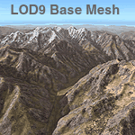
Detailed terrain mesh of the Southeastern Himalayan Ranges, N26-32 E90-98. The files in this package are based on Shuttle Radar (SRTM) Version 2 data but with many of the void areas, especially the most significant sections, filled with elevation data generated from topographic maps by Jonathan de Ferranti. While Jonathan's work is unrelated to flight simulation he kindly gave me permission to compile his data for use in FS. The result is a wonderful improvement in detail and accuracy over any existing mesh file, freeware or commercial, based on SRTM or DTED data alone.
Due to the large area of the Himalayas I've compiled the source data as two separate series: the "Himalayan Peaks" series covers prominent mountains and ranges in higher detail and locally overrides any existing LOD9 terrain mesh. In addition, a LOD9 "base mesh" series, with LOD8 and LOD7 "buffer" mesh files, covering the entire Himalayas, is meant for those who do not yet have an add-on terrain mesh of these beautiful mountains.
| Filename: | Himalayas_LOD9_Base_Mesh_Volume_1__Southeastern_Ra.zip |
| License: | Freeware, limited distribution |
| Added: | 29th May 2010, 09:01:26 |
| Downloads: | 10,298 |
| Author: | Holger Sandmann, Jonathan de Ferranti |
| Size: | 71.82 MB |
| Category: Flight Simulator 2004 - Scenery | |
| Himalayas LOD9 Base Mesh, Volume 2 - Southcentral Ranges |
|
Images related to this file:
File Description:

Detailed terrain mesh of the Southcentral Himalayan Ranges, N26-32 E82-90. The files in this package are based on Shuttle Radar (SRTM) Version 2 data but with many of the void areas, especially the most significant sections, filled with elevation data generated from topographic maps by Jonathan de Ferranti. While Jonathan's work is unrelated to flight simulation he kindly gave me permission to compile his data for use in FS. The result is a wonderful improvement in detail and accuracy over any existing mesh file, freeware or commercial, based on SRTM or DTED data alone.
Due to the large area of the Himalayas I've compiled the source data as two separate series: the "Himalayan Peaks" series covers prominent mountains and ranges in higher detail and locally overrides any existing LOD9 terrain mesh. In addition, a LOD9 "base mesh" series, with LOD8 and LOD7 "buffer" mesh files, covering the entire Himalayas, is meant for those who do not yet have an add-on terrain mesh of these beautiful mountains.
| Filename: | Himalayas_LOD9_Base_Mesh_Volume_2__Southcentral_Ra.zip |
| License: | Freeware, limited distribution |
| Added: | 29th May 2010, 09:05:56 |
| Downloads: | 9,447 |
| Author: | Holger Sandmann, Jonathan de Ferranti |
| Size: | 90.25 MB |
| Category: Flight Simulator 2004 - Scenery | |
| Himalayas LOD9 Base Mesh, Volume 4 - Kashmir and Jammu |
|
File Description:
Detailed terrain mesh of the Kashmir and Jammu Ranges, N30-39 E76-78. The files in this package are based on Shuttle Radar (SRTM) Version 2 data but with many of the void areas, especially the most significant sections, filled with elevation data generated from topographic maps by Jonathan de Ferranti. While Jonathan's work is unrelated to flight simulation he kindly gave me permission to compile his data for use in FS. The result is a wonderful improvement in detail and accuracy over any existing mesh file, freeware or commercial, based on SRTM or DTED data alone.
Due to the large area of the Himalayas I've compiled the source data as two separate series: the "Himalayan Peaks" series covers prominent mountains and ranges in higher detail and locally overrides any existing LOD9 terrain mesh. In addition, the LOD9 "base mesh" series, with LOD8 and LOD7 "buffer" mesh files, covering the entire Himalayas, is meant for those who do not yet have an add-on terrain mesh of these beautiful mountains.
| Filename: | Himalayas_LOD9_Base_Mesh_Volume_4__Kashmir_and_Jam.zip |
| License: | Freeware, limited distribution |
| Added: | 22nd February 2006, 20:32:50 |
| Downloads: | 7,503 |
| Author: | Holger Sandmann, Jonathan de Ferranti |
| Size: | 29.24 MB |
© 2001-2026 AVSIM Online
All Rights Reserved
Privacy Policy |