
Where Flight Simulation Enthusiasts Gather from Around the World!
AVSIM Library - Search Results

| Category: Flight Simulator X - Scenery | |
| Refuge du Gouter |

|
Images related to this file:
File Description:
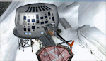
Mountain Huts In the Alps close to the peak of the Mont Blanc. Built in autumn 2012 ,it will replace the old refuge .
I add an helipad to the refuge ,but you can choose the original version,there is 2 Bgl included. By Manolo Dobrazil - Feb 2013.
| Filename: | Refuge_du_Gouter.zip |
| License: | Freeware |
| Added: | 1st February 2013, 23:55:46 |
| Downloads: | 509 |
| Author: | Manolo Dobrazil |
| Size: | 2.33 MB |
| Category: Prepar3D V1-4 - Scenery | |
| ITALY ETM20m - Enhanced Terrain Mesh vol. 02 |
|
Images related to this file:
File Description:
Italy - ETM Enhanced Terrain Mesh 0.73 arc sec (20 meters). This Terrain Mesh is fully compatible with FSX/P3D (all versions). This is a work in progress. Volume 02 - Campania, Basilicata and Puglia
| Filename: | ITALY_ETM20m__Enhanced_Terrain_Mesh_vol_02.zip |
| License: | Freeware |
| Added: | 17th December 2018, 23:46:26 |
| Downloads: | 358 |
| Author: | Giovanni Miduri |
| Size: | 44.15 MB |
| Category: Prepar3D V1-4 - Scenery | |
| ITALY ETM20m - Enhanced Terrain Mesh vol. 06 |
|
Images related to this file:
File Description:
Italy - ETM Enhanced Terrain Mesh 0.73 arc sec (20 meters). This Terrain Mesh is fully compatible with FSX/P3D (all versions). This is a work in progress. Volume 06 - Liguria and Emilia Romagna
| Filename: | ITALY_ETM20m__Enhanced_Terrain_Mesh_vol_06.zip |
| License: | Freeware |
| Added: | 17th December 2018, 23:48:30 |
| Downloads: | 343 |
| Author: | Giovanni Miduri |
| Size: | 48.03 MB |
| Category: Flight Simulator X - AFCAD Files | |
| VQPR - Paro Intl Airport,Tibet |
|
Images related to this file:
File Description:
A modification of default Paro Intl Airport, Tibet for FSX using ADE with information from google earth. Addon terrain mesh is required as default FSX mesh is incorrect and makes the airport unusable.
| Filename: | VQPR__Paro_Intl_AirportTibet.zip |
| License: | Freeware |
| Added: | 2nd September 2013, 13:29:20 |
| Downloads: | 553 |
| Author: | Himanshu Singh |
| Size: | 3.05 KB |
| Category: Flight Simulator 2004 - Scenery | |
| Hawaii Islands SRTM Terrain Mesh |
|
File Description:
76m LOD9 SRTM Terrain Mesh of the Hawaiian Islands.
| Filename: | Hawaii_Islands_SRTM_Terrain_Mesh.zip |
| License: | Freeware, limited distribution |
| Added: | 24th July 2004, 05:43:13 |
| Downloads: | 9,067 |
| Author: | Tom Finley |
| Size: | 6.57 MB |
| Category: Flight Simulator 2004 - Scenery | |
| Europe SRTM mesh part 01: LOD7 buffer mesh |
|
File Description:
Europe SRTM LOD9 mesh part 1 of 13: This is a LOD7 mesh covering the whole Europe from 35°N to 60°N and 12°W to 30°E, to be used as a buffer mesh in conjection with the LOD9 mesh. This Europe SRTM project was optimized for the lowest HDD space use: Each part macthing exactly the boundaries of its neighbors, you'll have a complete corevage of Europe without gap or overlapping scenery. Based on SRTM Data v1 and v2 (3 arcsec, 90m) and sampled to LOD7 resolution (300m). Each SRTM tile was carefully checked and repaired with Blackart v4.02: water areas are now flattened (lighter mesh), and SRTM voids were treated taking advantage of Blackart's sophisticated interpolation algorithm. When required, biggest voids were patched with oversampled SRTM 30 arcsec data and/or manual input.
| Filename: | Europe_SRTM_mesh_part_01_LOD7_buffer_mesh.zip |
| License: | Freeware, limited distribution |
| Added: | 19th October 2005, 16:11:05 |
| Downloads: | 19,059 |
| Author: | Yohann Baptiste |
| Size: | 50.28 MB |
| Category: Flight Simulator 2004 - Scenery | |
| Sierra Nevada Mesh. |
|
File Description:
Terrain mesh from SRTM 3 arc second (90m) data for Sierra Nevada Mountains.
This file covers the area of latitude N35-39 and longitude W117-119. Its lenght roughly from Bakersfield California to Reno Nevada, and width from the edge of Death Valley to Fresno.
| Filename: | Sierra_Nevada_Mesh.zip |
| License: | Freeware |
| Added: | 4th January 2004, 20:54:47 |
| Downloads: | 5,675 |
| Author: | Bart Dylkiewicz |
| Size: | 15.86 MB |
| Category: Flight Simulator X - Scenery | |
| Alesund 10m Mesh |
|
File Description:
Alesund 10 metre mesh for FSX only.
Alesund is found on the West coast of Norway. (The same as most other populated places in Norway!)
This is near 10m mesh, which Jonathan de Ferranti of: http://www.viewfinderpanoramas.org/ has kindly allowed me to turn into a BGL for use in Microsoft FSX.
The coverage isn't all that large: From 007 East Longitude to 009 East Longitude, 61 North Latitude to 62 North Latitude. (Points on SW corner of each Lat/Long box) Area is in the shape of a 'T'.
| Filename: | Alesund_10m_Mesh.zip |
| License: | Freeware |
| Added: | 10th March 2009, 16:44:28 |
| Downloads: | 1,129 |
| Author: | Wayne Evans |
| Size: | 62.48 MB |
| Category: Fly! II - Scenery | |
| Austria Mesh East |
|
File Description:
Elevation mesh based on 3° SRTM elevation-data from 46°N 14°E to 49°N 19°E. The Area around my Austrian Airports is manually corrected.
| Filename: | Austria_Mesh_East.zip |
| License: | Freeware |
| Added: | 12th January 2004, 14:30:33 |
| Downloads: | 622 |
| Author: | Harald Kraft |
| Size: | 3.97 MB |
| Category: Fly! II - Scenery | |
| LOGF Mesh fix |
|
File Description:
This file contains the SCENERY.Sxx file for my LOGF-Scenery which is necessary to use it with Helmut Mayers mesh OE-OST.
My original D011165.POD contains the elevation data and the SCENERY.Sxx-File. To use Helmuts mesh I have created LOGFMESH.POD, which only contains the SCENERY.SXX-File.
If you have my LOAN-Sscenery, remove also D011166.POD.
| Filename: | LOGF_Mesh_fix.zip |
| License: | Freeware |
| Added: | 1st August 2002, 11:45:27 |
| Downloads: | 151 |
| Author: | Harald Kraft |
| Size: | 2.94 KB |
© 2001-2026 AVSIM Online
All Rights Reserved
Privacy Policy |