
Where Flight Simulation Enthusiasts Gather from Around the World!
AVSIM Library - Search Results

| Category: Flight Simulator 2004 - Scenery | |
| Proyecto Mexico Real LOD8 (MESH) |

|
Images related to this file:
File Description:
Terrain Mesh that covers the entirety of Mexican Territory and related bordering U.S., Guatemala and Belize areas, part of the "Proyecto Mexico Real" project, compiled at LOD8 (4.96 arcseconds in latitude and 6.6 arcseconds in longitude) resolution from INEGI data. Intended to enhance the virtual flying experience with the more detailed LOD9 and LOD10 versions compiled from the same data. Compatible backwards with Flight Simulator 2000, Flight Simulator 2002 and Combat Flight Simulator 2. (Re-upload due to AVSIM hack)
| Filename: | Proyecto_Mexico_Real_LOD8_MESH.zip |
| License: | Check within download |
| Added: | 23rd January 2010, 11:37:33 |
| Downloads: | 3,611 |
| Author: | Juan Jose Galvan Bautista |
| Size: | 56.76 MB |
| Category: Prepar3D V1-4 - AI Aircraft | |
| KLM Alps JBAI Dornier 328-100 |
|
Images related to this file:
File Description:

A repaint of the JBAI Dornier 328-100 into the colors of KLM Alps OE-LKD, circa 2000.
| Filename: | KLM_Alps_JBAI_Dornier_328100.zip |
| License: | Freeware, limited distribution |
| Added: | 16th September 2020, 23:47:14 |
| Downloads: | 70 |
| Author: | Joakim Zenk |
| Size: | 945.09 KB |
| Category: Flight Simulator 2004 - Scenery | |
| Hauraki Gulf, v6 |
|
Images related to this file:
File Description:
This replaces all my previous Pakatoa Island and Hauraki Gulf sceneries. You must have Christian Stock's NZ mesh in the form of "Mountains of New Zealand" and topo in the form of "Lakes and Rivers of New Zealand" (payware).
New additions...PAKIHI ISLAND: Small jetty and nearby buildings. TAKANGAROA ISLAND: House on Island. House & Jetty island north of Takangaroa Island. MOTUREKAREKA ISLAND: Wreck of the Rewa. PONUI ISLAND: Chamberlain's Bay Airstrip. Chamberlain's Donkey Farm. Third Bay Airstrip. Motunau Bay Jetty. KARAMURAMU ISLAND: Jetty and quarry. ROTOROA ISLAND: Rotoroa Jetty. MOTUIHE ISLAND: Motuihe Wharf.
| Filename: | Hauraki_Gulf_v6.zip |
| License: | Freeware |
| Added: | 17th April 2010, 16:10:12 |
| Downloads: | 218 |
| Author: | Godfrey Tier |
| Size: | 6.61 MB |
| Category: Flight Simulator 2004 - AI Flight Plans | |
| Viking Airlines (UK ops) Winter 2008/09 |
|
File Description:
Viking Airlines UK flightplans for Winter 2008. Contains all charter flights from London Gatwick to Egypt, Lapland and the Alps.
| Filename: | Viking_Airlines_UK_ops_Winter_200809.zip |
| License: | Freeware, limited distribution |
| Added: | 27th January 2009, 21:18:09 |
| Downloads: | 740 |
| Author: | Stephen Wiseman |
| Size: | 6.32 KB |
| Category: Flight Simulator 2004 - Scenery | |
| Devils Tower Terrain Mesh (ver 2) |
|
File Description:
This terrain mesh covers most of Crook County, Wyoming which contains Devils Tower National Monument. This terrain mesh was obtained from NED 1 arc second data and resampled to LOD10 resolution (38.2m). The area near the Devils Tower was obtained from NED 1/3 arc second data and resampled to LOD11 resolution (19.1m). The exact coverage is everything between W105* 7' 30" to W104* 0' 0" by N45* 0' 0" to N44* 15' 0". Devils Tower can be found by starting at Ipy Ranch (WY14) and traveling on a track of 194 degrees for 3 nautical miles. This version corrects a major positional error that was present in the first release and includes higher resolution data near the Devils Tower.
| Filename: | Devils_Tower_Terrain_Mesh_ver_2.zip |
| License: | Freeware |
| Added: | 26th November 2003, 00:25:13 |
| Downloads: | 3,555 |
| Author: | Joshua Robertson, 3D Softworks Design Studios |
| Size: | 4.54 MB |
| Category: Flight Simulator X - Scenery | |
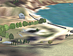
| Refuge des Grands Mulets - Glacier des Bossons - Chamonix, France |
|
Images related to this file:
File Description:
New version of this hut. Next to Chamonix in French Alps, at 3050m.
You can land on the roof. Have fun !
| Filename: | Refuge_des_Grands_Mulets__Glacier_des_Bossons__Cha.zip |
| License: | Freeware, limited distribution |
| Added: | 27th November 2014, 21:30:54 |
| Downloads: | 911 |
| Author: | Manolo Dobrazil |
| Size: | 3.28 MB |
| Category: Flight Simulator 2004 - Scenery | |
| Project México Real LOD10 File 4 of 11 |
|
File Description:
File 4th of 11 of a Terrain Mesh that covers the entire Mexican Territory and related areas bordering the U.S., Guatemala and Belice areas. Part of the "Proyecto México Real" project, compiled at LOD10 (1.24 arcseconds in latitude and 1.65 arcseconds in longitude) resolution from INEGI data. Intended to enhance the virtual flying experience complementing the LOD8 and LOD9 versions compiled from the same data. Compatible backwards with Flight Simulator 2000, Flight Simulator 2002 and Combat Flight Simulator 2. Refer to the file contents about the cover area to this compressed file.
| Filename: | Project_Mxico_Real_LOD10_File_4_of_11.zip |
| License: | Check within download |
| Added: | 6th June 2006, 00:58:59 |
| Downloads: | 3,065 |
| Author: | Juan José Galván Bautista |
| Size: | 74.49 MB |
| Category: Flight Simulator 2004 - Scenery | |
| Project México Real LOD10 File 6 of 11 |
|
File Description:
File 6th of 11 of a Terrain Mesh that covers the entire Mexican Territory and related areas bordering the U.S., Guatemala and Belice areas. Part of the "Proyecto México Real" project, compiled at LOD10 (1.24 arcseconds in latitude and 1.65 arcseconds in longitude) resolution from INEGI data. Intended to enhance the virtual flying experience complementing the LOD8 and LOD9 versions compiled from the same data. Compatible backwards with Flight Simulator 2000, Flight Simulator 2002 and Combat Flight Simulator 2. Refer to the file contents about the cover area to this compressed file.
| Filename: | Project_Mxico_Real_LOD10_File_6_of_11.zip |
| License: | Check within download |
| Added: | 6th June 2006, 01:07:16 |
| Downloads: | 3,022 |
| Author: | Juan José Galván Bautista |
| Size: | 71.63 MB |
| Category: Flight Simulator 2004 - Scenery | |
| Project México Real LOD10 File 11 of 11 |
|
File Description:
File 11th of 11 of a Terrain Mesh that covers the entirety of Mexican Territory and related bordering U.S., Guatemala and Belice areas, part of the "Proyecto México Real" project, compiled at LOD10 (1.24 arcseconds in latitude and 1.65 arcseconds in longitude) resolution from INEGI data. Intended to enhance the virtual flying experience complementing the LOD8 and LOD9 versions compiled from the same data. Compatible backwards with Flight Simulator 2000, Flight Simulator 2002 and Combat Flight Simulator 2. Refer to the file contents about the cover area to this compressed file.
| Filename: | Project_Mxico_Real_LOD10_File_11_of_11.zip |
| License: | Check within download |
| Added: | 6th June 2006, 01:52:33 |
| Downloads: | 3,095 |
| Author: | Juan José Galván Bautista |
| Size: | 69.98 MB |
| Category: Flight Simulator 2004 - Scenery | |
| Project Mexico Real LOD10 File 10 of 11 |
|
Images related to this file:
File Description:
Re-upload. File 10th of 11 of a Terrain Mesh that covers the entirety of Mexican Territory and related bordering U.S., Guatemala and Belice areas, part of the "Proyecto Mexico Real" project, compiled at LOD10 (1.24 arcseconds in latitude and 1.65 arcseconds in longitude) resolution from INEGI data. Intended to enhance the virtual flying experience complementing the LOD8 and LOD9 versions compiled from the same data. Compatible backwards with Flight Simulator 2000, Flight Simulator 2002 and Combat Flight Simulator 2. Refer to the file contents about the cover area to this compressed file.
| Filename: | Project_Mexico_Real_LOD10_File_10_of_11.zip |
| License: | Check within download |
| Added: | 5th September 2010, 20:55:05 |
| Downloads: | 3,060 |
| Author: | Juan Jose Galvan Bautista |
| Size: | 70.54 MB |
© 2001-2026 AVSIM Online
All Rights Reserved
Privacy Policy |