
Where Flight Simulation Enthusiasts Gather from Around the World!
AVSIM Library - Search Results

| Category: Flight Simulator X - Scenery | |
| Quebec Elevation 38m (LOD10) (3/5) |

|
File Description:
FSX 38m (Lod10) terrain mesh files of the province of Quebec, Canada (range : N45-N52, W56-W80) (5 zip files).
**************************
Donnees d'elevation de terrain (FSX - 38 metres) de la province de Quebec, Canada (couverture : N45-N52, W56-W80).
| Filename: | Quebec_Elevation_38m_LOD10_35.zip |
| License: | Freeware, limited distribution |
| Added: | 31st January 2007, 21:45:36 |
| Downloads: | 6,484 |
| Author: | Gilles Gauthier |
| Size: | 39.48 MB |
| Category: Flight Simulator X - Scenery | |
| Quebec Elevation 38m (LOD10) (5/5) |
|
File Description:
FSX 38m (Lod10) terrain mesh files of the province of Quebec, Canada (range: N45-N52, W56-W80) (5 zip files).
*************************
Donnees d'elevation de terrain (FSX - 38 metres) de la province de Quebec, Canada (couverture : N45-N52, W56-W80)
| Filename: | Quebec_Elevation_38m_LOD10_55.zip |
| License: | Freeware, limited distribution |
| Added: | 31st January 2007, 21:46:00 |
| Downloads: | 7,605 |
| Author: | Gilles Gauthier |
| Size: | 39.44 MB |
| Category: Flight Simulator X - Scenery | |
| Quebec Elevation 38m (LOD10) (1/5) |
|
File Description:
FSX 38m (Lod10) terrain mesh files of the province of Quebec, Canada (range: N45-N52, W56-W80) (5 zip files).
*************************
Donnees d'elevation de terrain (FSX - 38 metres) de la province de Quebec, Canada (couverture : N45-N52, W56-W80)
| Filename: | Quebec_Elevation_38m_LOD10_15.zip |
| License: | Freeware, limited distribution |
| Added: | 31st January 2007, 21:44:57 |
| Downloads: | 10,988 |
| Author: | Gilles Gauthier |
| Size: | 44.37 MB |
| Category: Flight Simulator 2004 - Scenery | |
| "Himalayan Peaks" LOD10 Mesh, Volume 4 - Annapurna |
|
Images related to this file:
File Description:

Highly detailed terrain mesh of the Annapurna area, N28-30 E83-85. The files in this package are based on Shuttle Radar (SRTM) Version 2 data but with many of the void areas, especially the most significant sections, filled with elevation data generated from topographic maps by Jonathan de Ferranti. While Jonathan's work is unrelated to flight simulation he kindly gave me permission to compile his data for use in FS. The result is a wonderful improvement in detail and accuracy over any existing mesh file, freeware or commercial, based on SRTM or DTED data alone.
Due to the large area of the Himalayas I've compiled the source data as two separate series: the "Himalayan Peaks" series covers prominent mountains and ranges in higher detail and locally overrides any existing LOD9 terrain mesh. In addition, a LOD9 "base mesh" series covering the entire Himalayas will be available for those who do not yet have an add-on terrain mesh of these beautiful mountains.
| Filename: | Himalayan_Peaks_LOD10_Mesh_Volume_4__Annapurna.zip |
| License: | Freeware, limited distribution |
| Added: | 29th May 2010, 08:59:29 |
| Downloads: | 10,460 |
| Author: | Holger Sandmann, Jonathan de Ferranti |
| Size: | 15.07 MB |
| Category: Flight Simulator 2004 - Scenery | |
| "Himalayan Peaks" LOD10 Mesh, Volume 5 - Garhwal |
|
File Description:
Highly detailed terrain mesh of the Garhwal area, N30°-32° E78°-81°. The files in this package are based on Shuttle Radar (SRTM) Version 2 data but with many of the void areas, especially the most significant sections, filled with elevation data generated from topographic maps by Jonathan de Ferranti. While Jonathan's work is unrelated to flight simulation he kindly gave me permission to compile his data for use in FS. The result is a wonderful improvement in detail and accuracy over any existing mesh file, freeware or commercial, based on SRTM or DTED data alone. Due to the large area of the Himalayas I've compiled the source data as two separate series: the "Himalayan Peaks" series covers prominent mountains and ranges in higher detail and locally overrides any existing LOD9 terrain mesh. In addition, a LOD9 "base mesh" series covering the entire Himalayas will be available for those who do not yet have an add-on terrain mesh of these beautiful mountains.
| Filename: | Himalayan_Peaks_LOD10_Mesh_Volume_5__Garhwal.zip |
| License: | Freeware, limited distribution |
| Added: | 18th February 2006, 23:16:47 |
| Downloads: | 10,131 |
| Author: | Holger Sandmann and Jonathan de Ferranti |
| Size: | 27.72 MB |
| Category: Flight Simulator 2004 - Scenery | |
| Masterton, New Zealand |
|
File Description:
NZMS - Hood Aerodrome - Masterton - New Zealand.
For FS2004.
Made to fit Christian Stock's NZ 20-mesh and Topo;
aka. "Mountains of New Zealand" and "Roads and Rivers of New Zealand".Don't know what it would be like with the 75-mesh - probably hopeless with default scenery.
This is not meant to be accurate, but is a fairly true representation.
It's meant to give you the "feel" of being there.
| Filename: | Masterton_New_Zealand.zip |
| License: | Freeware |
| Added: | 4th July 2008, 23:35:17 |
| Downloads: | 502 |
| Author: | Godfrey Tier |
| Size: | 2.49 MB |
| Category: Flight Simulator 2004 - Scenery | |
| Hastings, New Zealand |
|
File Description:
NZHS - Hastings Aerodrome - Bridge Pa - Hastings - New Zealand. Made to fit Christian Stock's NZ 20-mesh and Topo;
aka. "Mountains of New Zealand" and "Roads and Rivers of New Zealand".Don't know what it would be like with the 75-mesh - probably hopeless with default scenery.
This is not meant to be accurate, but is a fairly true representation. It's meant to give you the "feel" of being there.
| Filename: | Hastings_New_Zealand.zip |
| License: | Freeware |
| Added: | 9th July 2008, 01:35:12 |
| Downloads: | 573 |
| Author: | Godfrey Tier |
| Size: | 3.97 MB |
| Category: Flight Simulator 2004 - Scenery | |
| Guadalupe Mountains National Park SRTM30_1ArcSec Terrain Mesh |
|
File Description:
USGS SRTM30 1 arc-second, resampled to LOD10 (38.2 meters).
This terrain mesh is centered in western Texas panhandle.
Coverage area: From West 104° to West 106° and North 31° to North 32°.
It includes Guadalupe Mountains National Park and its surrounding areas.
| Filename: | Guadalupe_Mountains_National_Park_SRTM30_1ArcSec_T.zip |
| License: | Freeware, limited distribution |
| Added: | 27th December 2003, 19:07:04 |
| Downloads: | 1,294 |
| Author: | Andreas Trawny |
| Size: | 7 MB |
| Category: Flight Simulator 2004 - Scenery | |
| Quintin NZQT, New Zealand |
|
Images related to this file:
File Description:
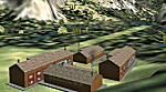
A small landing-strip on the Milford Track, New Zealand. For chartered-only aircraft. A pleasant ride from NZMF, up the valley to Quintin Lodge.
You must have Christian Stock's NZ mesh in the form of "Mountains of New Zealand"
and topo in the form of "Lakes and Rivers of New Zealand".
| Filename: | Quintin_NZQT_New_Zealand.zip |
| License: | Freeware |
| Added: | 4th July 2010, 10:17:09 |
| Downloads: | 305 |
| Author: | Godfrey Tier |
| Size: | 91.79 KB |
| Category: Flight Simulator 2004 - Scenery | |
| "Himalayan Peaks" LOD10 Mesh, Volume 3 - Namcha Barwa |
|
File Description:
Highly detailed terrain mesh of the Namcha Barwa area, N29°-31° E94°-96°. The files in this package are based on Shuttle Radar (SRTM) Version 2 data but with many of the void areas, especially the most significant sections, filled with elevation data generated from topographic maps by Jonathan de Ferranti. While Jonathan's work is unrelated to flight simulation he kindly gave me permission to compile his data for use in FS. The result is a wonderful improvement in detail and accuracy over any existing mesh file, freeware or commercial, based on SRTM or DTED data alone. Due to the large area of the Himalayas I've compiled the source data as two separate series: the "Himalayan Peaks" series covers prominent mountains and ranges in higher detail and locally overrides any existing LOD9 terrain mesh. In addition, a LOD9 "base mesh" series covering the entire Himalayas will be available for those who do not yet have an add-on terrain mesh of these beautiful mountains.
| Filename: | Himalayan_Peaks_LOD10_Mesh_Volume_3__Namcha_Barwa.zip |
| License: | Freeware, limited distribution |
| Added: | 18th February 2006, 23:15:17 |
| Downloads: | 12,185 |
| Author: | Holger Sandmann and Jonathan de Ferranti |
| Size: | 15.09 MB |


© 2001-2026 AVSIM Online
All Rights Reserved
Privacy Policy |