
Where Flight Simulation Enthusiasts Gather from Around the World!
AVSIM Library - Search Results

| Category: Flight Simulator 2004 - Scenery | |
| Driftwood Bay AK23 near Dutch Harbor Alaska |

|
Images related to this file:
File Description:
This is Driftwood Bay, an Air Force field that is just 13 miles northwest of Dutch Harbor, and was once part of a DEW line station with a road heading up the hill.
In FS9 the stock runway is concrete and if you have a mesh with the hills correctly positioned then the runway sits in a deep hole on the hillside. In fact the runway is gravel, 3,500 feet long and aligned 32/14 next to the beach, which is where I moved it to. The beach, as configured by Ultimate Terrain (and contrary to my previous doubts, UT does cover the Aleutians) is incorrect, in that a marshy area just behind the beach is shown as sea with large indentations in what should be a fairly straight line of sand. However, this does not squeeze AK23 in any way so I left it; consider it to be a spring high tide. There is very little at AK23 beyond a gravel runway and a windsock and the AI is an Alaska State Troopers Piper Super Cub from Dutch Harbor, presumably monitoring the numerous Alaska Maritime National Wildlife Refuge areas.
| Filename: | Driftwood_Bay_AK23_near_Dutch_Harbor_Alaska.zip |
| License: | Freeware, limited distribution |
| Added: | 14th August 2012, 20:32:14 |
| Downloads: | 351 |
| Author: | Roger Wensley, Sidney Schwartz |
| Size: | 3.35 MB |
| Category: Flight Simulator 2004 - AI Flight Plans | |
| Alaska Airlines and Horizon Air Summer 2005 |
|
File Description:
Alaska Airlines, Horizon Air, and partners ERA Aviation and Pen Air flightplans package based on week 25th July 2005 - 31st July 2005. 100% of flights included, 7700 in total. The flightplan is for the second half of the summer season. Special Livery information included. Ttools2 flightplans and MRAI Installer formatted flightplans. Generated with MRAI compiler. From PERFICAD.
| Filename: | Alaska_Airlines_and_Horizon_Air__Summer_2005.zip |
| License: | Freeware, limited distribution |
| Added: | 31st July 2005, 22:16:40 |
| Downloads: | 2,442 |
| Author: | Carl Edwards |
| Size: | 118.13 KB |
| Category: Flight Simulator X - Scenery | |
| Hughes, Huslia and Pitka Airports, Alaska Upgrades |
|
Images related to this file:
File Description:
This scenery upgrades HUS, PAHL and PAGA airports in Alaska. Upgrades include airport buildings, hangers, aircraft, ground vehicles and lots of eye candy. Also upgrades some taxiways, perimeter fencing and tarmacs. Also upgraded to include airport helipads for software such as Flight1's Helitraffic for AI helicopters and for future works for AI helo and bush plane traffic. (Coming Soon). Please read the text file for easy installation instructions. Includes pics of some of the upgraded airports. Created to enhance your Alaskan adventures so please enjoy. By Savageagle.
| Filename: | Hughes_Huslia_and_Pitka_Airports_Alaska_Upgrades.zip |
| License: | Freeware |
| Added: | 24th November 2011, 11:31:46 |
| Downloads: | 1,518 |
| Author: | Tim Durham |
| Size: | 1.08 MB |
| Category: Flight Simulator X - Scenery | |
| Merle K (Mudhole) Smith Airport, Cordova, Alaska |
|
Images related to this file:
File Description:
Completely re-done. Realish.
| Filename: | Merle_K_Mudhole_Smith_Airport_Cordova_Alaska.zip |
| License: | Freeware |
| Added: | 4th May 2018, 04:41:30 |
| Downloads: | 653 |
| Author: | Sidney Schwartz |
| Size: | 6.68 MB |
| Category: Flight Simulator 2004 - Scenery | |
| 8AK7 - Bullen Point - Alaska North Slope 7 |
|
Images related to this file:
File Description:
The town of Barrow is in the far north of Alaska, and these are coastal villages or radar installations to the west, south, and now east of Barrow. There will be further additions. Bullen Point is a DEW station Air Force base 240 miles east of Barrow and 75 miles east of Oliktok. The runway is just under 4,000 feet of gravel and aligned 05-23; this is approximately at right angles to the default FS9 alignment and how that came about is something I doubt Bill Gates could explain. Most of the DEW buildings have now been removed (including the large hangar, which is unusual) but as I had a layout I made the whole site as it was originally, way back in the days when the north slope was still a wilderness. The AI is one day a C-130, on another a Cessna, and on a third a DC3. When I started this North Slope series it was my intention to create the full monty and make all the oil and gas installations and Deadhorse airport etc. I have come to realise that the oil side is impossible to make. There is so much of it and each bit is as time consuming as Heathrow while the actual airfields are more like Rockcliffe CYRO, so a lot of effort for what is just background to an adjoining airfield. But at the same time, if I make the new airstrips it is impossible NOT to make the oil installations as they are the dominating feature. So no new airstrips, and this is going to be just the 1960's or 1970's, when the oil business was only exploratory and the airfields were for villages or DEW stations, and Harmon Helmerick had his dirt strip on the Colville River estuary and was guiding hunters and fishermen and had just started to help out Sinclair Oil with oil exploration in 1966. Read his book. Download my previous post of his field.
| Filename: | 8AK7__Bullen_Point__Alaska_North_Slope_7.zip |
| License: | Freeware, limited distribution |
| Added: | 15th July 2016, 17:46:54 |
| Downloads: | 277 |
| Author: | Roger Wensley |
| Size: | 2.5 MB |
| Category: Flight Simulator 2004 - Scenery | |
| Alaska North Slope 9; Point Hope PAPO |
|
Images related to this file:
File Description:
The town of Barrow is in the far north of Alaska, and these are coastal villages or radar installations to the west, south, and east of Barrow on the North Slope. There will be further additions. Point Hope is a village on a spit of land that is one of the oldest and continuously inhabited places in all of North America, not just the polar regions. The "Point" is what brought this about, migrating whales passing close to land as they rounded the point, and the traditional way of life continues to this day. The population is now around 670. The airport surpassed all my expectations of FS9. Go look at the area before you install this. The first thing you will notice is that FS9 does not list Point Hope PAPO. The town is there (way too big and in totally the wrong place) and the airport background is there (wrong place of course) but there is no airport! Some buildings, but no runway, no apron, nothing that can be used by a plane?!? In real life the town is 3 miles east of the point, the runway is situated between town and point and, unusually in the north, is asphalt. This is presumably possible because of the gravel make-up of the point itself, with very little vegetable content and the warming sea restricting permafrost movements. 4,000 feet of 75 feet wide asphalt, lit, PAPI at both ends, and aligned 01-19. The building that appears to be wrongly situated away from the apron is like that intentionally; it is a helicopter hangar (not used in winter?) and they presumably did not want the apron traffic to get in their way. The AI has daily flights by ERA, plus Northern Air Cargo, and some GA.
| Filename: | Alaska_North_Slope_9_Point_Hope_PAPO.zip |
| License: | Freeware, limited distribution |
| Added: | 25th July 2016, 20:20:35 |
| Downloads: | 253 |
| Author: | Roger Wensley |
| Size: | 3.02 MB |
| Category: Flight Simulator 2004 - Scenery | |
| Alaska South Slope 10; Port Clarence KPC |
|
Images related to this file:
File Description:
There are four main northwestern Alaska towns which are serviced by Alaska Airlines, and from which local flights spread out. The northernmost is Barrow. Southwest of Barrow is Kotzebue, then Nome, and the furthest south is Bethel (not yet made). This is the third in a series for local flights from Nome, and it is on the coast around 40 miles east of Wales, and 65 miles northwest of Nome. There are two other airfields around a large lagoon that is almost totally enclosed from the sea, and Port Clarence is on the end of the enclosing spit. Port Clarence was, until the LORAN navigation system went out of use, a Coastguard Station that had a LORAN transmitter, with an impressive mast that was 1,350 feet tall. It "was" as the mast was demolished in 2010, after the LORAN systems had been closed down in stages (LORAN-A in 1980 in the US, LORAN-C in 2010). In the meantime the runway had been lengthened to around 8,500 feet, and continued to be used by the Coastguard. Port Clarence has a population of 24, in theory, though presumably the census information refers to Coastguard personnel in the buildings of the LORAN station. The date for this scenery is anytime you like so long as it is before 2010 as the mast is still there. The AI includes Coastguard C-130 Hercules and helicopter flights, plus a weekly fuel delivery by Everts Air Fuel in a fancy colour scheme (Wednesday) and a daily visit by Bering so Coast Guards can go to civilisation in Nome.
| Filename: | Alaska_South_Slope_10_Port_Clarence_KPC.zip |
| License: | Freeware, limited distribution |
| Added: | 23rd October 2016, 18:53:14 |
| Downloads: | 231 |
| Author: | Roger Wensley |
| Size: | 3.05 MB |
| Category: Flight Simulator 2004 - Scenery | |
| Alaska South Slope 11; Brevig Mission KTS |
|
Images related to this file:
File Description:
There are four main northwestern Alaska towns which are serviced by Alaska Airlines, and from which local flights spread out. The northernmost is Barrow. Southwest of Barrow is Kotzebue, then Nome, and the furthest south is Bethel (not yet made). This is the fourth in a series for local flights from Nome, and it is on the coast around 50 miles east of Wales, and 60 miles northwest of Nome. There are two other airfields around a large lagoon that is almost totally enclosed from the sea, and Brevig Mission is on the northern shore, just 12 miles northeast of the already-posted Port Clarence. Brevig Mission has a populaton that has risen to 390 in recent years. Tollef Brevik was a Lutheran missionary who was both a pastor and teacher for the Inuit in the area from 1894 onward, travelling from community to community but based in Teller, 6 miles southeast. the village now called Brevig Mission was founded at a later date (unknown to me) and took his name. The airstrip is just east of the village, with two gravel runways; 11-29 which is 3,600 feet of gravel and 04-22 which is 2,600 feet and with PAPI on 22. The AI is the usual for this area, Bering and ERA with some GA and cargo by Everts.
| Filename: | Alaska_South_Slope_11_Brevig_Mission_KTS.zip |
| License: | Freeware, limited distribution |
| Added: | 25th October 2016, 20:52:56 |
| Downloads: | 198 |
| Author: | Roger Wensley |
| Size: | 2.55 MB |
| Category: Flight Simulator X - AFCAD Files | |
| OOK - Toksook Bay Airport, Toksook Bay, Alaska. |
|
File Description:
This is a redesign of OOK - Toksook Bay Airport, Toksook Bay, Alaska. Google Maps and Skyvector have been used to provide the correct (as physically possible within FSX and ADE) position, size and type of runway, aprons and buildings. The immediate surrounding scenery has been included. ADE used to compile the design.
| Filename: | OOK__Toksook_Bay_Airport_Toksook_Bay_Alaska.zip |
| License: | Freeware |
| Added: | 12th March 2018, 22:14:59 |
| Downloads: | 275 |
| Author: | Matthew Ward |
| Size: | 1.1 MB |
| Category: Flight Simulator 2004 - Aircraft Repaints, Textures and Modifications | |
| Alaska Airlines "Refreshed Livery" Boeing 737-800 |
|
Images related to this file:
File Description:
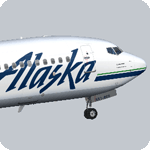
Alaska Air revealed a new updated paint scheme in February 2015, with small changes to modernize the brand. The Alaska logotype has a new smoother look. The dark blue is now navy, and the teal accents have been replaced with a brighter green. The eskimo logo remains unchanged, except the teal outline has been removed. Finally, the winglets now feature a swooped design rather than the traditional stripes.
Model developed by Tenkuu Developers Studio, features high resolution textures, dynamic flexing wings, nose gear steering, rudder lock, ground spoilers, low speed aileron locks at high speed, fully animated control surfaces, fully independent suspension, trim animation, opening passenger doors, rolling wheels, animated thrust reversers with reverser block doors, detailed textures, full night lighting, ground service vehicles and more. Model design by Hiroshi Igami. Flight dynamics design by Nick Wilkinson, with assistance from David Biggar. Master textures and paint kit by Kyle Schurb. Painted on the great TDS model. Enjoy!
| Filename: | Alaska_Airlines_Refreshed_Livery_Boeing_737800.zip |
| License: | Freeware |
| Added: | 23rd February 2015, 13:40:11 |
| Downloads: | 675 |
| Author: | Joe Shimmel | Tenkuu Developers Studio |
| Size: | 9.05 MB |
© 2001-2026 AVSIM Online
All Rights Reserved
Privacy Policy |