
Where Flight Simulation Enthusiasts Gather from Around the World!
AVSIM Library - Search Results

| Category: Flight Simulator X - Scenery | |
| South America Mesh Scenery, MeshX_E4 |

|
File Description:
Mesh terrain scenery for the whole continental South America, based on SRTM 90m
dem geotiff files (at: ftp://ftp.glcf.umiacs.umd.edu/glcf/SRTM/Degree_Tiles/),
resampled to 76 meter of horizontal resolution (LOD 9). The new files have
improved the vertical resolution from 16m to 10m, resulting in more details
and accuracy over previous versions. There are 50 files, compatible with FS 9
and FS X, identified in a map by column letter and line number, covering the
contiguous countries and states. Boundaries: N = 5º 37.5' S; S = 11º 15' S;
E = 41º 15' W; W = 48º 45' W;
| Filename: | South_America_Mesh_Scenery_MeshX_E4.zip |
| License: | Freeware |
| Added: | 28th October 2006, 05:55:47 |
| Downloads: | 1,528 |
| Author: | Oséas Dourado and José Lôbo |
| Size: | 38.91 MB |
| Category: Flight Simulator 2004 - Aircraft Repaints, Textures and Modifications | |
| Tassili Airlines, Pilatus PC-6 Porter |
|
Images related to this file:
File Description:

The PC-6 is noted for its Short Take-off and Landing (STOL) performance on almost any type of terrain - it can take off within a distance of 195 m and land within a distance of 130 m while carrying a payload of 1,500 kg, that's why it's the natural choice for Tassili Airlines wish operate in desert areas, repaint for the FSD PC6 Porter model.
| Filename: | Tassili_Airlines_Pilatus_PC6_Porter.zip |
| License: | Freeware, limited distribution |
| Added: | 2nd April 2011, 21:55:28 |
| Downloads: | 389 |
| Author: | HABA Zine el abidine |
| Size: | 9.21 MB |
| Category: Flight Simulator 2004 - Scenery | |
| VFR of Lario, Area D2 - Como lake, Italy |
|
Images related to this file:
File Description:
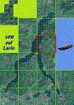
This is the seventh scenery of the "VFR of Lario" project, made with photorealistic terrain and some 3D GMax realistic objects. This scenery covers approximately an area of 7.5x6 kmt, from
north of Bellano (NW) to Casargo (NE), and from Fiumelatte (SW) to Cortenova (SE) and includes the NLC piers of Varenna and Bellano; it includes several dedicated buildings as Vezio castle (Perledo), villa Monastero, S.Giorgio church, marina, piers, hotel Olivedo, and some villas (Varenna), Tommaso Grossi square with pier and light fountain, S.Nazaro-Celso and S.Rocco-Sebastiano churches, Cantoni old cotton mill, group of houses by the lake (Bellano). There are also included four viaducts between the tunnels of the freeway 36, with moted traffic. Hydrofoil G. Marconi at Bellano pier together with other minor boats and docks alongside the lake coast; a moted traffic of motorboats is placed between Varenna's piers.
| Filename: | VFR_of_Lario_Area_D2__Como_lake_Italy.zip |
| License: | Freeware |
| Added: | 23rd July 2012, 15:45:14 |
| Downloads: | 1,259 |
| Author: | Aldo Della Vedova, Daniele Lanfranchi, Gian Mario Verga |
| Size: | 17.95 MB |
| Category: Flight Simulator 2004 - Scenery | |
| Colorado Lakes Project III |
|
File Description:
This project features the lakes of Southwest Colorado, replaces the default Navajo Lake on the Colorado-New Mexico border, and adds over 300 highly detailed lakes to Colorado. They fit seamlessly with my "Colorado Lakes Project II" (colorado_lakes_project_2.zip) and "Colorado Lakes Project I" (colorado_lakes_project_1.zip) lakes. The original "Colorado Lakes Project I" is recommended to complete this package, as it contains McPhee, Lemon, and Vallecito Reservoirs.
These lakes are specifically designed to show off their photo realistic detail when used in combination with "FSGenesis-The Rockies 38.2m Terrain Mesh-Colorado" available as "fsg_dem38m_usrk_co.zip" at avsim.com, or comparable mesh. The free FSGenesis US National Landclass Project Beta 6 also adds beautifully to the landscape. These lakes work equally as well with the default mesh.
All lake information was projected from satellite imagery and compiled with a beta version of Jim Keir's "Slartibartfast" utility.
| Filename: | Colorado_Lakes_Project_III.zip |
| License: | Freeware |
| Added: | 3rd June 2004, 21:54:46 |
| Downloads: | 5,010 |
| Author: | Carlyle Sharpe |
| Size: | 444 KB |
| Category: Flight Simulator 2004 - Scenery | |
| Colorado Lakes Project IV |
|
File Description:
This project features the lakes of North Central Colorado, replaces all of the prominent reservoirs and lakes of the region (Dillon, Green Mountain, Granby, Williams Fork, and more), and adds over 500 highly detailed lakes to Colorado. They fit seamlessly with my "Colorado Lakes Project III" (colorado_lakes_project_3.zip), "Colorado Lakes Project II" (colorado_lakes_project_2.zip) and "Colorado Lakes Project I" (colorado_lakes_project_1.zip) lakes.
These lakes are specifically designed to show off their photo realistic detail when used in combination with "FSGenesis-The Rockies 38.2m Terrain Mesh-Colorado" available as "fsg_dem38m_usrk_co.zip" at avsim.com, or comparable mesh. The free FSGenesis US National Landclass Project Beta 6 also adds beautifully to the landscape. These lakes work equally as well with the default mesh.
All lake information was projected from satellite imagery and compiled with a beta version of Jim Keir's "Slartibartfast" utility.
| Filename: | Colorado_Lakes_Project_IV.zip |
| License: | Freeware |
| Added: | 10th June 2004, 04:27:10 |
| Downloads: | 4,829 |
| Author: | Carlyle Sharpe |
| Size: | 743.4 KB |
| Category: Flight Simulator X - Scenery | |
| KDAY - Dayton International Airport - Vandalia, Ohio |
|
Images related to this file:
File Description:
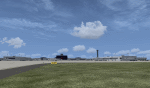
The Dayton International Airport, located 11 miles north of Dayton in Vandalia, Ohio, is a medium sized commercial airport serving nearly three million passengers annually with daily nonstop service to about twenty destinations.
This scenery includes a custom terminal building, moving jetways, and an AFX file with accurate parking assignments. Also modeled is the new air traffic control tower, terminal parking garage, the Fed Ex building, the PSA Airlines headquarters and maintenance hanger, the former Emery Worldwide cargo sort facility, the airport hotel, and hangers for fixed base operators Stevens Aviation and Wright Brothers Aero.
More than a thousand objects have been added to enhance detail around the airport using Flight 1's excellent instant scenery program. AI Traffic has been tested to ensure efficient flow. The landclass file has also been adjusted to better reflect the real airport.
| Filename: | KDAY__Dayton_International_Airport__Vandalia_Ohio.zip |
| License: | Freeware |
| Added: | 2nd December 2012, 22:32:37 |
| Downloads: | 1,567 |
| Author: | Matt Parr |
| Size: | 5.78 MB |
| Category: Prepar3D V1-4 - Scenery | |
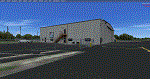
| KCEY, Kyle-Oakley Field Murray KY USA (P3D) |
|
Images related to this file:
File Description:
KCEY is a public use, single runway airport located 4 miles NW of Murray KY. Runway 5/23 is an asphalt runway 6203x100 feet long. 100LL, Jet-A and MOGAS are available at this airport.
I added an area of photo real about a mile square around the airport. It blends best with Orbx Global and LC North America. All the airport objects such as hangers, fences, fuel tanks, signs, etc. are all custom made objects based on pictures obtained on-site. The runways, taxiways and aprons are all custom textures as well as runway and taxiway lights. This is an authentic recreation of the real world airport.
| Filename: | KCEY_KyleOakley_Field_Murray_KY_USA_P3D.zip |
| License: | Freeware |
| Added: | 12th March 2018, 22:15:59 |
| Downloads: | 204 |
| Author: | Shannan G Landreth |
| Size: | 66.74 MB |
| Category: Prepar3D V1-4 - Scenery | |
| KJQD, Ohio County Airport Hartford, KY USA |
|
Images related to this file:
File Description:
KJQD is a public use, one runway airport located 3 miles NE of Hartford KY.
Runway 3/21 is an asphalt runway 5000x75 feet long. 100LL and Jet-A are available at this airport.
I added an area of photo real about a mile square around the airport. It blends best with Orbx Global and LC North America. All the airport objects such as hangers, fences, fuel tanks, signs, etc. are all custom made objects based on pictures obtained on-site. The runways, taxiways and aprons are all custom textures as well as runway and taxiway lights. This is an authentic recreation of the real world airport.
| Filename: | KJQD_Ohio_County_Airport_Hartford_KY_USA.zip |
| License: | Freeware |
| Added: | 22nd January 2018, 23:09:44 |
| Downloads: | 353 |
| Author: | Shannan G Landreth |
| Size: | 46.33 MB |
| Category: Flight Simulator 2004 - Scenery | |
| Bay Bridge Airport (W29) - Stevensville, Maryland, USA |
|
File Description:
This file updates Bay Bridge Airport (W29) with some enhanced scenery. Bay Bridge is a smaller airport at the base of the Chasapeake Bay bridge. The approach to this airport gives an amazing view of the bridge and the bay. One interesting note about this airport is that it lies within the Washington Air Defense Identification Zone (ADIZ). This means that special procedures are required departing and landing at this airport in real life. Of course, in FS2004, it doesn't matter, but try to follow the proper procedures as much as possible in the game for a challenge. This file includes a custom afcad and optional static aircraft.
| Filename: | Bay_Bridge_Airport_W29__Stevensville_Maryland_USA.zip |
| License: | Freeware, limited distribution |
| Added: | 22nd April 2006, 19:14:12 |
| Downloads: | 1,159 |
| Author: | Craig Swartzlander |
| Size: | 6.83 KB |
| Category: Flight Simulator X - AFCAD Files | |
| Lhasa Gonggar (ZULS) Update 1.2 - Tibet, China |
|
Images related to this file:
File Description:
This update to the ZULS airport I created using the freeware Airport Design Editor X (v1.47.07), it includes:
-an extended vehicle taxi network that surrounds the perimeter of the airport
-extended jetways, resized parkings radius and taxipaths
-additional and touch up on some airport objects' appearance and/or position, including a rotating tower beacon at night
with FSX object libraries. Some objects (lightposts and car parking lots) from the Acceleration pack are added for more realism, but may not be visible for the FSX RTM users.
This scenery is designed based on photos taken from Google Maps and other sites about the Lhasa Gonggar Airport.
| Filename: | Lhasa_Gonggar_ZULS_Update_12__Tibet_China.zip |
| License: | Freeware |
| Added: | 5th August 2010, 20:44:02 |
| Downloads: | 944 |
| Author: | Harry Sung |
| Size: | 424.7 KB |
© 2001-2026 AVSIM Online
All Rights Reserved
Privacy Policy |