
Where Flight Simulation Enthusiasts Gather from Around the World!
AVSIM Library - Search Results

| Category: Flight Simulator 2004 - Scenery | |
| LIMN Cameri, Italy (UPDATED v2) |

|
Images related to this file:
File Description:
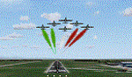
This scenery is a homage to the great military airport of Cameri NO, Italy; it has been revised with complete new ground that solves the previous flickering problems; it is builded-up with ownmade GMax objects and other existing ones; some buildings by GMax, remainder by others and by Generic Building system.
Information: Built during 1910 close to Novara, it became a prestigious Flight School where a lot of pilots of WWI where trained. Later, Gabardini/CANSA entered by promoting and developing aviation activities, mainly establishing a military flight school. On 27th July 1914, first of story's time, a flight from Cameri crossed the Alps (Camery - Viege, over Monte Rosa) with a Gabardini 80HP aircraft and pilot Achille Landini together with Giuseppe Lampugnani passenger. On 1930 the school closed, but the field still remained as aviation workshop. During the WWII the airport was quite destroyed by the german army, during their retreat. After the war, the rebuild operations carried on to Cameri several details, of which the acrobatic patrol of "Lancieri Neri" and, 1967-1999, the great 53th "Stormo Caccia". On 1998 the storm was moved to Gioia del Colle airport and the base was restructured as Comand Airport, where some technical departments still works (the 453th Operative Technical Services Group, the 553th Logistic Operative Services Group and, mainly the 1st Aircrafts Maintenance Dep.nt)
Contents: all around new great terrain for about 4.5 x 3.5 km; static aircraft inside hangar as Tornado, Eurofighter and historic monoliths at admittance and inside airport; ground equipments, cars outside and inside airport, bus, tankers, emergency trucks; military shelters (10) and workshop ones (5); buildings outside/inside airport, control tower, VOR, radar tower and some other navaids; lights at hangars, admittance and all over the boundaries; more then 10 km boundary by walls and fences of the complete areas; thousands trees all over the scenery. This scenery includes the airport scenery content only. You can find separate further sceneries for Babini Army station and Museum
| Filename: | LIMN_Cameri_Italy_UPDATED_v2.zip |
| License: | Freeware |
| Added: | 20th October 2011, 00:20:05 |
| Downloads: | 2,357 |
| Author: | Aldo Della Vedova, Daniele Lanfranchi |
| Size: | 25.08 MB |
| Category: Flight Simulator 2004 - AFCAD Files | |
| Cherokee County Airport |
|
File Description:
Upgrade of the stock version of Cherokee County Airport (47A) to the airport as it is right now. Real airport is still in construction to become a Regional Airport and I have made this AFCAD to show the airport as of now. I have added a new 5000ft runway with adjacent taxiway, 16 extra parking spots, and runway 22 is equipped with ILS and MALSAR.
| Filename: | Cherokee_County_Airport.zip |
| License: | Freeware |
| Added: | 23rd November 2008, 11:32:35 |
| Downloads: | 179 |
| Author: | Brandon Kiefer |
| Size: | 559.41 KB |
| Category: Flight Simulator 2002 - Scenery | |
| Niederrhein-Düsseldorf Airport |
|
File Description:
Scenery for the new Niederrhein-Düsseldorf airport. The airport used to be RAF Laarbruch, but after it was retired by the UK, it has been turned into a Civil Passenger and Freight airport. The airport is located in the German province of Northrhein-Westfalen, very close to the border with the Netherlands. Main airline operating from the airport is Ryanair, with 3 flights daily to London Stansted.
| Filename: | NiederrheinDsseldorf_Airport.zip |
| License: | Freeware, limited distribution |
| Added: | 30th April 2003, 17:48:00 |
| Downloads: | 2,833 |
| Author: | iFDG |
| Size: | 1.27 MB |
| Category: Prepar3D V1-4 - Scenery | |
| VELP Lengpui Airport Aizawl |
|
File Description:
P3D/FSX VELP Lengpui Airport (IATA: AJL, ICAO: VELP) is a domestic airport in Aizawl, Mizoram, India.
The airport is connected by daily flights with Guwahati and Kolkata and three flights a week with Imphal and is located at a distance of 32 km from Aizawl, the capital of Mizoram. Lengpui Airport is the first large airport in the country to be built by the State Government
| Filename: | VELP_Lengpui_Airport_Aizawl.zip |
| License: | Freeware |
| Added: | 25th October 2018, 18:00:18 |
| Downloads: | 1,263 |
| Author: | Sachin Gnath |
| Size: | 7.21 MB |
| Category: Flight Simulator 2002 - Scenery | |
| NY-New York City, Central Park Area Terrain Mesh (10m) |
|
File Description: Take a break and enjoy Sunday afternoon in the park. This high resolution mesh demonstrates the amount of detail FS2002 is able to display. But you will not see any improvement in the park if you are still using the default value of TERRAIN_MAX_VERTEX_LEVEL=19 (in the [TERRAIN] section) of your fs2002.cfg file! This value is adequate for the default mesh, but will not display all the additional detail available in mesh constructed from 30m or better source data. I recommend a value of 21 for the most detail, but a value of 20 may be preferable if FPS is a serious problem. Hop in your favorite helicopter, depart from La Guardia (KLGA) airport, and head west toward the city. (If you are new to helicopters, set your Aircraft realism to Easy and turn off Crash Detection while getting started - and relax in this scenic park!)
| Filename: | NYNew_York_City_Central_Park_Area_Terrain_Mesh_10m.zip |
| License: | Freeware, limited distribution |
| Added: | 21st July 2002, 17:35:04 |
| Downloads: | 2,845 |
| Author: | Steve Greenwood |
| Size: | 1017.33 KB |
| Category: Flight Simulator 2004 - Scenery | |
| California Central Coast Ultimate Terrain USA Compatible Version Revision 1 |
|
File Description:
This is revision #1 to CCCOASTU.ZIP dated 9/13/05 and only applies to that UT USA compatible version of my California Central Coast Scenery. Revised Morro Rock, added taxiway designations and signs at PRB, several other tweaks. CCCOASTU.ZIP is required.
| Filename: | California_Central_Coast_Ultimate_Terrain_USA_Comp.zip |
| License: | Freeware |
| Added: | 13th October 2005, 22:56:57 |
| Downloads: | 1,204 |
| Author: | Al Wheeler |
| Size: | 985.45 KB |
| Category: Flight Simulator X - Scenery | |
| Sicily VFR - Terrain Mesh SRTM 1 Arc/Sec version 3 |
|
Images related to this file:
File Description:
Enhanced Terrain Mesh with SRTM 1 Arc/Sec (30 meters) version 3 at LOD 11 (19mt meters/pixel). SRTM 1 Arc-Second Global elevation data offer worldwide coverage of void filled data at a resolution of 1 arc-second (30 meters/0,000278 degrees) and provide open distribution of this high-resolution global data set. The SRTM 1 Arc-Second Global (30 meters) data set released in phases starting September 24, 2014. Fully compatible also with P3D.
| Filename: | Sicily_VFR__Terrain_Mesh_SRTM_1_ArcSec_version_3.zip |
| License: | Freeware |
| Added: | 7th February 2015, 20:18:17 |
| Downloads: | 4,686 |
| Author: | Giovanni Miduri |
| Size: | 43.32 MB |
| Category: Strike Fighters: Project 1 - Mods, Utilities and Patches | |
| Enhanced Planning Maps for WoV's stock VietnamSEA terrain Version 1.0 |
|
File Description:
This is a very basic supplement to make it easier to design DRV missions. Paint Shop Pro 7 was used to combine WoV's planningmap2.bmp with an overlay. The overlay is a map from a game scenario book: p.2 of the DOWNTOWN Scenario Booklet by Lee Brimmicombe-Wood, published by GMT Games. The overlay and the stock map do not quite agree, but is reasonably accurate in the primary areas of interest: Thud Ridge, Hanoi, and Haiphong.
| Filename: | Enhanced_Planning_Maps_for_WoVs_stock_VietnamSEA_t.zip |
| License: | Freeware |
| Added: | 28th November 2005, 13:51:17 |
| Downloads: | 217 |
| Author: | Stephen Lynn Flores |
| Size: | 6.54 MB |
| Category: Flight Simulator 2004 - Scenery | |
| The Greater Toronto Area for Ultimate Terrain 1.2 Part 1 |
|
File Description:
Part 1 of Flight Ontario's scenery for the Greater Toronto Area for Ultimate Terrain. The scenery is bounded by Detroit in the west, Kingston in the east, Huntsville in the north and Buffalo in the south and features: * all-season scenery * custom water textures * completely modelled Toronto Airports...CYTZ (Toronto Island) and CYZD (Downsview-home to Bombardier Aerospace and the Canadair Regional Jet and Dash-8, and the Toronto Aerospace Museum) * Niagara Helicopters CPQ3 (NEW) *custom autogen for the GTA * Custom landclass for southern Ontario * prominent features around Hamilton include the Burlington Skyway,lift bridge and steel mills * the Welland Canal is featured with lift bridges from Pt Weller to Pt Colborne * the Niagara area includes two hydro generating plants with reservoirs * compatibility with SimFlyers CYYZ.
This scenery is downloadable in two parts and both parts are essential.
| Filename: | The_Greater_Toronto_Area_for_Ultimate_Terrain_12_P.zip |
| License: | Freeware |
| Added: | 31st December 2005, 18:39:52 |
| Downloads: | 13,893 |
| Author: | Jim Kanold - Flight Ontario |
| Size: | 62.05 MB |
| Category: Flight Simulator X - Scenery | |
| Hay Fever farm (CO59) update |
|
Images related to this file:
File Description:
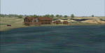
FSX Hay Fever farm (CO59) update
Galeton CO.Download FREE library of RWY12 - EZ scenery objects (available on FlightSim.com or AVSIM) for objects. Ultimate Terrain USA X for detailed landclass. FSX.
Instructions inside.
jimmy R martin
060606 upd: 112010
| Filename: | Hay_Fever_farm_CO59_update.zip |
| License: | Freeware |
| Added: | 21st November 2010, 08:28:11 |
| Downloads: | 286 |
| Author: | jimmy R martin |
| Size: | 308.18 KB |
© 2001-2026 AVSIM Online
All Rights Reserved
Privacy Policy |