
Where Flight Simulation Enthusiasts Gather from Around the World!
AVSIM Library - Search Results

| Category: Flight Simulator 2004 - Scenery | |
| Cincinnati/Northern Kentucky International Airport (KCVG) 2006 Update |

|
File Description:
Update to the KCVG-2006 scenery which added the new runway 18R/36L to Cincinnati/Northern Kentucky International Airport. Based on some feedback, a bgl file which flattens the airport terrain has been created, thereby eliminating the bleed-through issue some were experiencing. There were also some minor tweaks made to some of the taxiways in the AFCAD file.
In addition, Nick Stavropoulos has updated the AFCAD file to add 185 gates and parking for Delta/Delta connection, COA connection, NWA/NWA Jet Link, UAL/UAL Express, American Eagle, USAir, FedEX, USA3000, Miami Air and GA parking.
| Filename: | CincinnatiNorthern_Kentucky_International_Airport_.zip |
| License: | Freeware, limited distribution |
| Added: | 25th May 2006, 18:32:34 |
| Downloads: | 7,452 |
| Author: | George S. Marinakis and Nick Stavropoulos |
| Size: | 72.53 KB |
| Category: Flight Simulator 2004 - Scenery | |
| "Himalayan Peaks" LOD10 Mesh, Volume 8 - Tirich Mir and Pamir |
|
Images related to this file:
File Description:
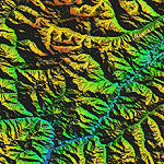
Highly detailed terrain mesh of the Tirich Mir and Pamir areas, N36-39 E71-74. The files in this package are based on Shuttle Radar (SRTM) Version 2 data but with many of the void areas, especially the most significant sections, filled with elevation data generated from topographic maps by Jonathan de Ferranti. While Jonathan's work is unrelated to flight simulation he kindly gave me permission to compile his data for use in FS. The result is a wonderful improvement in detail and accuracy over any existing mesh file, freeware or commercial, based on SRTM or DTED data alone.
Due to the large area of the Himalayas I've compiled the source data as two separate series: the "Himalayan Peaks" series covers prominent mountains and ranges in higher detail and locally overrides any existing LOD9 terrain mesh. In addition, a LOD9 "base mesh" series covering the entire Himalayas will be available for those who do not yet have an add-on terrain mesh of these beautiful mountains.
| Filename: | Himalayan_Peaks_LOD10_Mesh_Volume_8__Tirich_Mir_an.zip |
| License: | Freeware, limited distribution |
| Added: | 29th May 2010, 08:52:47 |
| Downloads: | 9,105 |
| Author: | Holger Sandmann, Jonathan de Ferranti |
| Size: | 47.94 MB |
| Category: Flight Simulator X - Scenery | |
| Mesh South America / MeSA E03 |
|
File Description:
FSX Mesh South America Project:
This terrain mesh file is a part of a whole project covering all the Continent
of South America and some islands, divided in tiles identified in a map by its
column (letters) and rows (numbers).
Those files were multi-LOD compiled from 90m SRTM2 source data, reprocessed
with 3DEM to remove voids and spikes, providing a 76.4m (LOD9) horizontal
resolution topography intended for use only in FSX updated with SP1.
Although not well documented, to improve performance, the updated FSX loads DEM
files in threads and only the closer terrain (about 5-10 NM from the point of view)
is rendered in high detail, while at far distances FSX shows up its default low
resolution mesh, when there is not a third part terrain mesh compiled in all
others intermediate level of details (multi-LOD).
THIS FILE:
FSX_MeSA_E03 (Column E x Row 03)
covers the area inside the boundaries:
N = 5º 37,5' N; S = 0º 0' S;
W = 60º 0' W; E = 52º 30' W;
| Filename: | Mesh_South_America__MeSA_E03.zip |
| License: | Freeware |
| Added: | 13th June 2007, 21:41:26 |
| Downloads: | 1,255 |
| Author: | Hely Heck Jr. and José Lôbo |
| Size: | 83.82 MB |
| Category: Flight Simulator X - Scenery | |
| FSX_MeSA_G08 |
|
File Description:
FSX Mesh South America Project:
This terrain mesh file is a part of a whole project covering all the Continent
of South America and some islands, divided in tiles identified in a map by its
column (letters) and rows (numbers).
Those files were multi-LOD compiled from 90m SRTM2 source data, reprocessed
with 3DEM to remove voids and spikes, providing a 76.4m (LOD9) horizontal
resolution topography intended for use only in FSX updated with SP1.
Although not well documented, to improve performance, the updated FSX loads DEM
files in threads and only the closer terrain (about 5-10 NM from the point of view)
is rendered in high detail, while at far distances FSX shows up its default low
resolution mesh, when there is not a third part terrain mesh compiled in all
others intermediate level of details (multi-LOD).
THIS FILE:
FSX_MeSA_G08 (Column G x Row 08)
covers the area inside the boundaries:
N = 22º 30' S; S = 28º 7.5' S;
W = 45º 0' W; E = 37º 30' W;
AUTHORS:
Hely Heck Junior - Magrao ( [email protected] )
and Jose Lobo ( [email protected] )
| Filename: | FSX_MeSA_G08.zip |
| License: | Freeware |
| Added: | 15th June 2007, 15:04:47 |
| Downloads: | 1,133 |
| Author: | Hely Heck Jr. and José Lôbo |
| Size: | 12 MB |
| Category: Flight Simulator X - Scenery | |
| FSX_MeSA_H04 |
|
File Description:
FSX Mesh South America Project:
This terrain mesh file is a part of a whole project covering all the Continent
of South America and some islands, divided in tiles identified in a map by its
column (letters) and rows (numbers).
Those files were multi-LOD compiled from 90m SRTM2 source data, reprocessed
with 3DEM to remove voids and spikes, providing a 76.4m (LOD9) horizontal
resolution topography intended for use only in FSX updated with SP1.
Although not well documented, to improve performance, the updated FSX loads DEM
files in threads and only the closer terrain (about 5-10 NM from the point of view)
is rendered in high detail, while at far distances FSX shows up its default low
resolution mesh, when there is not a third part terrain mesh compiled in all
others intermediate level of details (multi-LOD).
THIS FILE:
FSX_MeSA_H04 (Column H x Row 04)
covers the area inside the boundaries:
N = 0º 0' S; S = 5º 37.5' S;
W = 37º 30' W; E = 30º 0' W;
AUTHORS:
Hely Heck Junior - Magrao ( [email protected] )
and Jose Lobo ( [email protected] )
| Filename: | FSX_MeSA_H04.zip |
| License: | Freeware |
| Added: | 15th June 2007, 15:07:51 |
| Downloads: | 944 |
| Author: | Hely Heck Jr. and José Lôbo |
| Size: | 3.56 MB |
| Category: Flight Simulator X - Scenery | |
| FSX_MeSA_H05 |
|
File Description:
FSX Mesh South America Project:
This terrain mesh file is a part of a whole project covering all the Continent
of South America and some islands, divided in tiles identified in a map by its
column (letters) and rows (numbers).
Those files were multi-LOD compiled from 90m SRTM2 source data, reprocessed
with 3DEM to remove voids and spikes, providing a 76.4m (LOD9) horizontal
resolution topography intended for use only in FSX updated with SP1.
Although not well documented, to improve performance, the updated FSX loads DEM
files in threads and only the closer terrain (about 5-10 NM from the point of view)
is rendered in high detail, while at far distances FSX shows up its default low
resolution mesh, when there is not a third part terrain mesh compiled in all
others intermediate level of details (multi-LOD).
THIS FILE:
FSX_MeSA_H05 (Column H x Row 05)
covers the area inside the boundaries:
N = 5º 37.5' S; S = 11º 15' S;
W = 37º 30' W; E = 30º 0' W;
AUTHORS:
Hely Heck Junior - Magrao ( [email protected] )
and Jose Lobo ( [email protected] )
| Filename: | FSX_MeSA_H05.zip |
| License: | Freeware |
| Added: | 15th June 2007, 15:08:10 |
| Downloads: | 943 |
| Author: | Hely Heck Jr. and José Lôbo |
| Size: | 22.93 MB |
| Category: Flight Simulator X - Scenery | |
| FSX_MeSA_H06 |
|
File Description:
FSX Mesh South America Project:
This terrain mesh file is a part of a whole project covering all the Continent
of South America and some islands, divided in tiles identified in a map by its
column (letters) and rows (numbers).
Those files were multi-LOD compiled from 90m SRTM2 source data, reprocessed
with 3DEM to remove voids and spikes, providing a 76.4m (LOD9) horizontal
resolution topography intended for use only in FSX updated with SP1.
Although not well documented, to improve performance, the updated FSX loads DEM
files in threads and only the closer terrain (about 5-10 NM from the point of view)
is rendered in high detail, while at far distances FSX shows up its default low
resolution mesh, when there is not a third part terrain mesh compiled in all
others intermediate level of details (multi-LOD).
THIS FILE:
FSX_MeSA_H06 (Column H x Row 06)
covers the area inside the boundaries:
N = 11º 15' S; S = 16º 52.5' S;
W = 37º 30' W; E = 30º 0' W;
AUTHORS:
Hely Heck Junior - Magrao ( [email protected] )
and Jose Lobo ( [email protected] )
| Filename: | FSX_MeSA_H06.zip |
| License: | Freeware |
| Added: | 15th June 2007, 15:19:51 |
| Downloads: | 997 |
| Author: | Hely Heck Jr. and José Lôbo |
| Size: | 1.61 MB |
| Category: Flight Simulator X - Miscellaneous Files | |
| HD Moon Texture v3.0 |
|
Images related to this file:
File Description:

This update will replace all previous textures from version 2.0 - complete new rendering with new normal & bump map applied for better lunar terrain effect and converted to Extended 32-Bit Bitmap. Additionally it's now possible to use 2048x2048 instead of 1024x1024 or 512x512 resolved textures. This means a plus of 3200 % in terms of resolution compared with the default 64x64 textures.
| Filename: | HD_Moon_Texture_v30.zip |
| License: | Freeware |
| Added: | 17th September 2011, 10:20:25 |
| Downloads: | 5,025 |
| Author: | Marco Fischbach |
| Size: | 34.23 MB |
| Category: Flight Simulator 2004 - Scenery | |
| Lesser Antilles SRTM Mesh |
|
File Description:
This is a terrain mesh scenery for the whole lesser antilles, from the Anguilla Isl (north) to Trinidad Isl (south), including a small part of Venezuela.
Based on SRTM Data (3 arc/ sec), generated with Matthew Styles's program "SRTM To BGL v1.04", sampled to LOD9 resolution (76m) with 5 interpolation passes.
While tested under Fs2004, this mesh should also run in FS2002.
| Filename: | Lesser_Antilles_SRTM_Mesh.zip |
| License: | Freeware |
| Added: | 26th September 2003, 01:46:44 |
| Downloads: | 5,691 |
| Author: | Yohann Baptiste |
| Size: | 5.18 MB |
| Category: Flight Simulator 2004 - Scenery | |
| Northern Venezuela SRTM Mesh part 2 |
|
File Description:
This terrain mesh scenery covers north of Venezuela (southern boundary is 8°48'N) and Dutch caribeans: Aruba, Curacao & Bonaire islands.
Based on SRTM Data (3 arcsec, 90m), generated with Matthew Styles's program "SRTM To BGL v1.04", sampled to LOD9 resolution (76m) with 5 interpolation passes.
This part contains Venezuela-NW.bgl. See venezuela_n_mesh_pt2-1.jpg for the .BGL files coverage.
| Filename: | Northern_Venezuela_SRTM_Mesh_part_2.zip |
| License: | Freeware |
| Added: | 7th October 2003, 18:19:24 |
| Downloads: | 8,629 |
| Author: | Yohann Baptiste |
| Size: | 14.31 MB |
© 2001-2026 AVSIM Online
All Rights Reserved
Privacy Policy |