
Where Flight Simulation Enthusiasts Gather from Around the World!
AVSIM Library - Search Results

| Category: Navigation and ATC - Navigation | |
| Puerto Rico VI TAC Chunks for Aerosoft's FSMap |

|
File Description:
The chart chunks are from the latest Puerto Rico Virgin Islands TAC at the original scale, formatted in the WGS84 lat/long geographic coordinate system for the FSMap, moving map application for flight simulation use.
The chart chunks are baseline 8bit tiffs with packbit compression applied, not for size but for efficiency. The images are 3800x3806 pixels at about 13.5mb each. Also, included is the FSMap fsm Calibration file for importing.
| Filename: | Puerto_Rico_VI_TAC_Chunks_for_Aerosofts_FSMap.zip |
| License: | Freeware |
| Added: | 19th March 2010, 01:17:08 |
| Downloads: | 323 |
| Author: | David Myers |
| Size: | 21.19 MB |
| Category: Flight Simulator 2004 - Utilities | |
| FS Online Center 2007 V2.0 |
|
File Description:
FS Online Center is a Entertainment and Flight Planning Plugin for your Flight Simulator 9 Kneeboard. It contains a Web Browser with Favorites Integration, Tools and Links for Flight Planning, Weather Center for quick Metar Information and Satellite Images, Google Map, Wikipedia Browser, WINAMP Integration, PDF Viewer, Video Player, 111 Live ATC-Feeds, Inflight TV with 283 Online Web-TV Stations Worldwide, 6 different Kneeboard Skins and many more. Simple Installation.
| Filename: | FS_Online_Center_2007_V20.zip |
| License: | Freeware |
| Added: | 23rd January 2007, 14:23:18 |
| Downloads: | 17,178 |
| Author: | Steffen Froemter |
| Size: | 2.73 MB |
| Category: Flight Simulator 2004 - AFCAD Files | |
| KAMAv1209 |
|
Images related to this file:
File Description:

KAMAv1209 zip contains 2 bgl's (1 afcad and 1 for building placement), which reflect the New Terminal (pic #1) based on the diagram from the website (pic #2).
I used Google Earth for measurements, the current airport diagram, and info from the KAMA website for current gate assignments.
Created with AFX and IS for FS9 ONLY to replace the default AP.
Bonus file--
1) Printable Terminal Parking Map
Have Fun, Joe
| Filename: | KAMAv1209.zip |
| License: | Freeware |
| Added: | 22nd December 2009, 05:36:26 |
| Downloads: | 327 |
| Author: | Joe Bourgeois |
| Size: | 149.08 KB |
| Category: Flight Simulator X - AI Flight Plans | |
| Fantasy Dream - Itapemirim Brazil |
|
Images related to this file:
File Description:

This pack textures + flightplans is a fantasy dream with the legendary Itapemirim, a bus company from brazil with extense route map. In the 90s Itapemirim owned a regional and cargo airline, but this pack not have any similarity with this air division. This package have a textures with great Juergen Baumbusch and FC75 team paintkit for OSP ATR42 and original FAIB A320 paintkit. Enjoy this fantasy dream on your FSX.
| Filename: | Fantasy_Dream__Itapemirim_Brazil.zip |
| License: | Freeware |
| Added: | 12th February 2017, 07:13:24 |
| Downloads: | 280 |
| Author: | Alexandre Alves |
| Size: | 2.93 MB |
| Category: Flight Simulator 2004 - Scenery | |
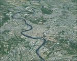
| Italy, Toscana 6, Firenze, Photo Real |
|
Images related to this file:
File Description:
Toscana, Italy, Photoreal Scenery Part 6 (Firenze).
The photoreal scenery covers a great area of Toscana (Tuscany) around the city of Firenze (Florence). The airport of Firenze Peretola (LIRQ) are found inside the scenery (see map). For the best results, use it in association with other parts of Toscana photoreal: Toscana 1 Grosseto, Toscana 2 Piombino, Toscana 3 Siena, Toscana 4 Poggibonsi, Toscana 5 Livorno_Lucca_Pisa_Pistoia, Toscana 7 Massa_Carrara, italy_islands_vfr_part2_nw.zip
| Filename: | Italy_Toscana_6_Firenze_Photo_Real.zip |
| License: | Freeware |
| Added: | 28th April 2010, 13:46:09 |
| Downloads: | 7,053 |
| Author: | Fulvio Mazzokan |
| Size: | 89.82 MB |
| Category: Flight Simulator X - Scenery | |
| Denmark V1.4 |
|
Images related to this file:
File Description: FSX Denmark Scenery v1.4 Part Two. The scenery includes a number of airports,
airfields and VFR landmarks throughout the country, with special attention to
the cities Copenhagen and Aalborg. This scenery is compatible with photo
sceneries, "Denmark Map x" and default FSX.

It is recommended to read the wiki:
http://www.fsonline.dk/en/index.php?title=Denmark_Scenery
before installing this package.
| Filename: | Denmark_V14.zip |
| License: | Freeware |
| Added: | 10th November 2012, 16:21:42 |
| Downloads: | 8,872 |
| Author: | The Denmark Scenery Team |
| Size: | 246.75 MB |
| Category: Flight Simulator X - Scenery | |
| Alfs UK airfields Volume 25 - EGBK Sywell/Northampton v2 |
|
Images related to this file:
File Description:
After being advised that Sywell/Northampton EGBK now had a concrete runway I decided to produce a new version of the one I made way back in volume 6. I have produced more custom buildings though I can't guarantee 100% accuracy due to lack of detailed pictures. Over the buildings area it can be used with either sharp FSX ground textures or fuzzy Google map landclass textures, whatever you prefer.
| Filename: | Alfs_UK_airfields_Volume_25__EGBK_SywellNorthampto.zip |
| License: | Freeware |
| Added: | 9th October 2012, 17:35:35 |
| Downloads: | 1,171 |
| Author: | Alf Denham |
| Size: | 8.04 MB |
| Category: Flight Simulator 2004 - Scenery | |
| Belg 7000 |
|
File Description:
Scenery "Belg7000 V2.0" (Belgium 2003) - For FS2004 only
Airport : EBSG-StGhislain - EBCV-Chièvres - EBTY-Maubray
The first part of Belgium scenery where you can fly in "VFR" over 1350 Square area.
scenery : Tournai-> StGhislain-> Mons-> Chièvres-> Ath-> Leuze.
Ebsg-Stghislain-> Condé/Escaut-> St Amand les Eaux (France) -> Ebty-Maubray.
Quiévrain-> Roisin-> Givry (view map).
Very very nice to fly at low altitude (1000-3000 ft) with an little aircraft.
| Filename: | Belg_7000.zip |
| License: | Freeware |
| Added: | 1st December 2003, 16:02:30 |
| Downloads: | 7,392 |
| Author: | Freddy Bridoux |
| Size: | 8.31 MB |
| Category: Strike Fighters: Project 1 - Mods, Utilities and Patches | |
| Enhanced Planning Maps for Gepard's DRVTerrain, Version 3.0 |
|
File Description:
This is a very basic supplement to make it easier to design DRV missions. Paint Shop Pro 7 was used to combine Gepard's planningmap2.bmp with an overlay. The overlay is a map from a game scenario book: p.2 of the DOWNTOWN Scenario Booklet by Lee Brimmicombe-Wood, published by GMT Games. Version 3 uses a completely new overlay. It appears to be more accurate and includes route package boundaries.
| Filename: | Enhanced_Planning_Maps_for_Gepards_DRVTerrain_Vers.zip |
| License: | Freeware |
| Added: | 27th November 2005, 17:32:06 |
| Downloads: | 254 |
| Author: | Stephen Lynn Flores |
| Size: | 3.38 MB |
| Category: Flight Simulator 2004 - Scenery | |
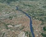
| Italy, Lazio 2, Roma, Photo Real |
|
Images related to this file:
File Description:
Lazio, Italy, Photoreal Scenery Part 2 (Roma).
The photoreal scenery covers a great area of Lazio around the city of Roma (Rome). The airports of Roma Urbe (ICAO code LIRU), Roma Fiumicino (LIRF) and Roma Ciampino (LIRA) are founds inside the scenery (see map). For the best results, use it in association with other parts of Lazio photoreal: Lazio 1 Viterbo, Lazio 3 Rieti, Lazio 4 Latina, Lazio 5 Gaeta.
| Filename: | Italy_Lazio_2_Roma_Photo_Real.zip |
| License: | Freeware |
| Added: | 1st June 2010, 20:38:25 |
| Downloads: | 15,706 |
| Author: | Fulvio Mazzokan |
| Size: | 78.89 MB |
© 2001-2026 AVSIM Online
All Rights Reserved
Privacy Policy |