
Where Flight Simulation Enthusiasts Gather from Around the World!
AVSIM Library - Search Results

| Category: Flight Simulator 2004 - AI Flight Plans | |
| Flightplans VOEPASS Linhas Aereas - November 2020 |

|
Images related to this file:
File Description:

Flightplans for AI TRAFFIC for VOEPASS Linhas Aereas (former PASSAREDO and MAP) scheduled flights between 16NOV-22NOV from ANAC Brazil SIROS system. Includes stored planes. By Alexandre Alves.
| Filename: | Flightplans_VOEPASS_Linhas_Aereas__November_2020.zip |
| License: | Freeware |
| Added: | 18th November 2020, 19:41:52 |
| Downloads: | 254 |
| Author: | Alexandre Alves |
| Size: | 6.69 KB |
| Category: Flight Simulator X - Scenery | |
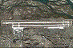
| SKRH (AEROPUERTO ALMIRANTE PADILLA, RIOHACHA, COLOMBIA) |
|
File Description:
SKRH file is the airpor with the runway with the current direction and airport buildings. It is done using google map.
Feel free to add anything you want.
| Filename: | SKRH_AEROPUERTO_ALMIRANTE_PADILLA_RIOHACHA_COLOMBI.zip |
| License: | Freeware |
| Added: | 21st June 2010, 01:41:10 |
| Downloads: | 1,119 |
| Author: | Anwar Gonzalez |
| Size: | 5.92 KB |
| Category: Flight Simulator 2004 - Scenery | |
| Italy, Campania 3, San Severo, Photo Real |
|
Images related to this file:
File Description:
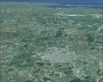
Campania, Italy, Photoreal Scenery Part 3 San Severo.
The photoreal scenery covers a great area of South Italy near Campania around the city of San Severo (see map). The airports of Amendola (ICAO code LIBA) and Gino Lisa (LIBF) are founds near the scenery (see map). For the best results, use it in association with other parts of Campania photoreal: Campania 1 Caserta, Campania 2 Napoli, Campania 4 Benevento, Campania 5 Melfi, Campania 6 Palinuro.
| Filename: | Italy_Campania_3_San_Severo_Photo_Real.zip |
| License: | Freeware |
| Added: | 4th June 2010, 11:18:10 |
| Downloads: | 6,118 |
| Author: | Fulvio Mazzokan |
| Size: | 78.94 MB |
| Category: Flight Simulator X - Aircraft Repaints, Textures and Modifications | |
| Intelliscente Boeing 747-400 V3 |
|
File Description:
This file is intended to be used with the Aerosoft/PMDG B747-400 v3 Passenger. It was made using the "Default" Boeing 747-400 from PMDG Version 3, not the "Combi", not the Freighter, not the -400ER, not the -400ERF or others (it was not tested with other passenger models). Only the "normal" B747-400. Tested with AES 2.25!
| Filename: | Intelliscente_Boeing_747400_V3.zip |
| License: | Freeware |
| Added: | 14th March 2017, 04:16:00 |
| Downloads: | 313 |
| Author: | Renato Roberto |
| Size: | 1.34 KB |
| Category: Flight Simulator X - Miscellaneous Files | |
| Quality Wings 787 - Additional maps for SYRIA |
|
Images related to this file:
File Description:
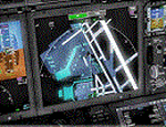
This package included 3 Main airports for syria For Qualitywings B787 Airport Map displayed into Navigation display. here is the airports: Damascus(OSDI) Bassel Al-Assad(OSLK) Aleppo(OSAP)
| Filename: | Quality_Wings_787__Additional_maps_for_SYRIA.zip |
| License: | Freeware |
| Added: | 19th October 2017, 17:10:18 |
| Downloads: | 399 |
| Author: | Mohamed Fawzi |
| Size: | 31.91 KB |
| Category: Navigation and ATC - Navigation | |
| Sectional Charts of the United States Pack 10 |
|
File Description:
High quality Sectional Charts for the United States. Specially calibrated to be used with FSMMM (FSM Moving Map) by Rana Hossain. This file includes: Billings and Great Falls Sectionals.
| Filename: | Sectional_Charts_of_the_United_States_Pack_10.zip |
| License: | Freeware |
| Added: | 26th February 2005, 18:56:18 |
| Downloads: | 6,629 |
| Author: | Matt Fox |
| Size: | 20.68 MB |
| Category: Flight Simulator 2004 - Utilities | |
| Navigation Data 2005 v2.1.0 |
|
File Description:
FS2004/FS2002/FS2000 Navigation Data - Version 2.1.0 - Navigation Database utility
for panels based on the RealCRT Gauge Series.
Needed for RealCRT.ND Map and Route modes.
(Alternative approach generation added)
| Filename: | Navigation_Data_2005_v210.zip |
| License: | Shareware, time limited |
| Added: | 17th November 2005, 05:14:13 |
| Downloads: | 6,760 |
| Author: | Tony D'Ambrosio |
| Size: | 6.58 MB |
| Category: Flight Simulator 2004 - AI Aircraft | |
| Mapjet Mc Donnell Douglas MD-83 'OE-IKB' |
|
Images related to this file:
File Description:

Map Executive Air Service Aardvark McDonnell Douglas MD-83 'OE-IKB' repaint for AI traffic including 'representative' Summer 09 charter FlightPlans. This is on an enhanced paintkit by myself.
| Filename: | Mapjet_Mc_Donnell_Douglas_MD83_OEIKB.zip |
| License: | Freeware |
| Added: | 17th November 2009, 11:41:13 |
| Downloads: | 537 |
| Author: | Billy Rutherford |
| Size: | 864.69 KB |
| Category: Flight Simulator X - Scenery | |
| Zuls airport |
|
Images related to this file:
File Description:
This file is the Lhasa Gonggar airport with the ILS for runway 27 only there are no airport buildings. It is done using google map. Included are two maps.
| Filename: | Zuls__airport.zip |
| License: | Freeware |
| Added: | 23rd May 2010, 01:33:24 |
| Downloads: | 338 |
| Author: | Anwar Gonzalez |
| Size: | 2.53 MB |
| Category: Navigation and ATC - Navigation | |
| Lake Huron Chart Chunks Optimized For Moving Map Application |
|
File Description:
Sectional chart chunks made from the August 2009 Sectional charts at the original scale, formatted in the WGS84 lat/lon geographic coordinate system for GPS, moving map application for flight simulation use.
These chart chunks were converted to the JPEG format for compatibility and size. Coverage is the full Sectional area North and South divided into 8 JPEG tiles. They are about 3k x 3k pixels at 2.5mb with coverage of 90nm x 130nm per tile. Included is also the projection files and world files.
Note: This type of map is a equal grid and no further calibration is needed, only the two points referenced in the world file. Example: for users of FSM Moving Map, just mass import, done.
| Filename: | Lake_Huron_Chart_Chunks_Optimized_For_Moving_Map_A.zip |
| License: | Freeware |
| Added: | 20th February 2010, 22:08:53 |
| Downloads: | 129 |
| Author: | David Myers |
| Size: | 20.82 MB |
© 2001-2026 AVSIM Online
All Rights Reserved
Privacy Policy |