
Where Flight Simulation Enthusiasts Gather from Around the World!
AVSIM Library - Search Results

| Category: Flight Simulator 2004 - Aircraft Repaints, Textures and Modifications | |
| FSP Air Macau Airbus A321 (B-MAP) |

|
File Description:
This is the FSP A321 #B-MAP "Air macau" colors with "4-th East Asian Games logo"). It's an AI aircraft but also flyable. Textures only! You need FSPs A321v25 basepack for the model.Works with Fs2004 and Fs2002.. Texture only!
| Filename: | FSP_Air_Macau_Airbus_A321_BMAP.zip |
| License: | Freeware |
| Added: | 13th September 2004, 22:51:54 |
| Downloads: | 786 |
| Author: | Aleks Pjarnja |
| Size: | 201.16 KB |
| Category: AVSIM File Library - Navigation and ATC | |
| Israel CVFR charts for FSM Moving Map |
|
File Description:
The two charts included here cover northern and southern Israel and show the required waypoints and flight paths for Controlled VFR (CVFR). They are calibrated for use in FSM Moving Map (FSMMM) by Rana Hossain. Calibration was performed primarily using the marked intersections of latitude and longitude lines. I am not entirely satisfied with the results. In most places, the accuracy seems to be off by about one mile. I do not know if this is my fault, or simply a limitation of the original map.
| Filename: | Israel_CVFR_charts_for_FSM_Moving_Map.zip |
| License: | Freeware |
| Added: | 2nd August 2005, 02:35:05 |
| Downloads: | 1,387 |
| Author: | David Wilson-Okamura |
| Size: | 3.75 MB |
| Category: Civil Flight Simulators - Looking Glass Flight Unlimited 3 | |
| Outer Terrain GTL Grid Structure Map v2.0 |
|
Images related to this file:
File Description:
This version of my GTL grid structure map includes Andre's new outer terrain area north of Seattle and adds a search facility, which enables you to search for a tile using FU3 world co-ordinates. To find out the world co-ordinates of any OT area simply open Fled, set the top-down view to the latitude/longitude of the area you're interested in and click the latitude/longitude figures that appear in the bottom left hand corner of the screen. The latitude/longitude figures will disappear and be replaced by FU3 world co-ordinates as easting and northing values. Enter these values into my FU3 GTL Map, click the button and the spreadsheet will map these co-ordinates to the correct tile and return the tile name. If you don't know the latitude/longitude of the area you're interested in then you can always obtain this from within the game itself. Just start a flight in the area you're interested in and press Ctrl-z at any time to enter Zoar mode. This will pause the game and display the current latitude/longitude in the top left hand corner of the screen.
| Filename: | Outer_Terrain_GTL_Grid_Structure_Map_v20.zip |
| License: | Freeware |
| Added: | 29th December 2009, 23:16:52 |
| Downloads: | 35 |
| Author: | Jonathan Stonehouse |
| Size: | 198.97 KB |
| Category: Flight Simulator 2004 - Gauges | |
| TerraVue: Moving Map, Ground Proximity, Information pages |
|
File Description:
FS2004 Gauge: TerraVue. This gauge contains a moving map display with a terrain elevation legend color-keyed to the FS9 map. The legend allows the elevation of terrain lying ahead of the aircraft to be taken into account. TerraVue can display the FS map in seven ranges from 4 NM to 160 NM. The Map mode also employs animation to show the proximity between the aircraft and ground in a graphical and digital display with indicators showing whether the distance is increasing or decreasing. The gauge can be switched to the Information mode which will display up to four individual pages of data that is created by you. These scrollable pages may contain checklists, airport diagrams, approach plates, strip charts, etc. Fully functional, free software to help quickly construct these pages is included along with an illustrated tutorial that demonstrates the simple copy/paste process that tailors these pages to include whatever data you wish. For panel or separate window installation with TerraVue Icon gauge. By Glenn Copeland
| Filename: | TerraVue_Moving_Map_Ground_Proximity_Information_p.zip |
| License: | Freeware |
| Added: | 24th June 2006, 15:13:12 |
| Downloads: | 5,073 |
| Author: | Glenn Copeland |
| Size: | 1.92 MB |
| Category: Prepar3D V1-4 - AFCAD Files | |
| Bridge Daxing ZBAD ND map For QW787 |
|
File Description:
For Bridge - Beijng Daxing INTL Airport ZBAD P3D with QW787
Put the .xml into Prepar3D v4\QualityWings\QW787\Navdata\APT Data\stock
Hope you enjoy it.
2019.11.12
| Filename: | Bridge_Daxing_ZBAD_ND_map_For_QW787.zip |
| License: | Freeware |
| Added: | 12th November 2019, 17:36:30 |
| Downloads: | 192 |
| Author: | Xu Lechuan |
| Size: | 39.52 KB |
| Category: Prepar3D V1-4 - Aircraft Repaints, Textures and Modifications | |
| Airbus A321 IAE Air Macau B-MAP |
|
Images related to this file:
File Description:

Repaint for FSLabs A321 IAE Air Macau B-MAP for P3Dv4HF3 & P3Dv5. Textures only. Installation instructions on readme file. Don't forget to visit and like us on Facebook! http://www.facebook.com/hangar226 http://elmikey.wixsite.com/hangar226.
| Filename: | Airbus_A321_IAE_Air_Macau_BMAP.zip |
| License: | Freeware |
| Added: | 10th November 2020, 23:13:38 |
| Downloads: | 188 |
| Author: | Miguel Angel Taboada |
| Size: | 16.5 MB |
| Category: Flight Simulator 2004 - Aircraft Repaints, Textures and Modifications | |
| Arkia DC-3 Repaint, 4X-AES |
|
File Description:
This is a repaint of the default DC-3 in Arkia's fifties livery.
The DC-3s were used by Arkia during the fifties on the Tel Aviv - Eilat route, until retired and sold to private hands.
This particular machine (4X-AES) we re-bought by Arkia for promotional purposes.
| Filename: | Arkia_DC3_Repaint_4XAES.zip |
| License: | Freeware, limited distribution |
| Added: | 15th March 2004, 01:46:36 |
| Downloads: | 1,197 |
| Author: | Oren Geva |
| Size: | 2.97 MB |
| Category: Flight Simulator 2004 - Aircraft Repaints, Textures and Modifications | |
| AES 2.21 All Nippon Airways textures |
|
Images related to this file:
File Description:
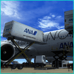
This set of ANA textures for your AES 2.21 contains:
Catering trucks,
Clean service (van and truck),
Stairs,
Cargo loaders,
Set of 4 tow trucks,
Ramp agent/marshaller (2 variations) with reflective jackets at night,
Tow driver,
Catering worker,
Two buses (long and short),
Bus driver,
| Filename: | AES_221_All_Nippon_Airways_textures.zip |
| License: | Freeware, limited distribution |
| Added: | 23rd April 2012, 23:11:58 |
| Downloads: | 1,065 |
| Author: | Guillem Roca - Aerosoft |
| Size: | 11.43 MB |
| Category: Flight Simulator 2004 - Miscellaneous Files | |
| Config File _ Mega Pack_v2 |
|
File Description:
This is an Update to my first AES - Mega Package.
I changed the 737-50north from freewar to payware folder and added the A318 -A320 from Wilco, which has been launched yet.
I hope you´ll gonna enjoy...
feedback welcome
| Filename: | Config_File___Mega_Pack_v2.zip |
| License: | Freeware |
| Added: | 4th February 2007, 05:17:21 |
| Downloads: | 4,785 |
| Author: | Maurizio Reith feat. Michel Hunziker & Sander van Esch |
| Size: | 14.16 MB |
| Category: Flight Simulator 2004 - Scenery | |
| Warrenton, VA Fauquier Airport - KHWY Updated |
|
File Description:
There is missing a new terminal that I didn't know Google Earth Map is outdated before they built a new terminal.
| Filename: | Warrenton_VA_Fauquier_Airport__KHWY_Updated.zip |
| License: | Freeware |
| Added: | 22nd June 2020, 21:38:37 |
| Downloads: | 68 |
| Author: | Stuart John Gilbert II |
| Size: | 1.67 MB |
© 2001-2026 AVSIM Online
All Rights Reserved
Privacy Policy |