
Where Flight Simulation Enthusiasts Gather from Around the World!
AVSIM Library - Search Results

| Category: Flight Simulator 2004 - Original Aircraft | |
| Lockheed L-1049 Super G Constellation |

|
Images related to this file:
File Description:
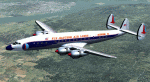
Lockheed L-1049G Super Constellation V2 - This re-uploaded version integrates the changes of the 20 May 2009 Update pack released elsewhere.
First flown in December 1954, the "Super G" was the most successful and
prestigious civil variant of Lockheed's Super Constellation series. It could
carry up to 99 passengers, and optional wing-tip tanks holding 600 gallons
each enabled it to comfortably fly the popular long-distance routes.
Included in the package are four models representing aircraft with and
without radar noses and tip tanks.
Natural metal TWA and Eastern textures by
Eric Joiner, KLM texture by Marcel Ritzema, panel textures and additional
gauges by Diego S. Barreto. Model, VC, and texture basics by Manfred Jahn,
panels, gauges, and animations by Hansjoerg Naegele, flight dynamics by Luis
Pallas, wingview angles by Bill Tyne and Andreas Trapp, lights and exhaust
effects by Roland Berger, checklist and documentation by Volker Boehme,
flight test and handling research by Stefan Werner. The 1049 project is
hosted by Tom Gibson's Calclassic forum at
http://calclassic.proboards55.com.
| Filename: | Lockheed_L1049_Super_G_Constellation.zip |
| License: | Freeware |
| Added: | 11th December 2009, 00:50:19 |
| Downloads: | 7,765 |
| Author: | Manfred Jahn and Team 1049 |
| Size: | 31.33 MB |
| Category: Flight Simulator 2004 - Scenery | |
| YEVD Evans Head Memorial, Australia |
|
File Description:
Googly scenery for YEVD Evans Head Memorial, a former RAAF Training base in
New South Wales, Australia, now reduced to a single runway and small apron.
In its heyday it was home to the RAAF No 1 Bombing and Gunnery and the RAAF No 1
Air Observers Schools and it was said to be the largest training base in the
southern hemisphere - at that time it had four runways.
Flight Simulator 2004 has made no provision for traffic with only a runway
provided and this scenery seeks to redress the situation so that you and your
"AI" traffic can use the airport.
The scenery does not purport to be ultra-accurate. Based on high quality
satellite imagery from Google Earth, the layout is proportionally correct but the
added airport features, such as buildings, are built from default Microsoft objects
and add-on libraries so will not look exactly like the real thing.
You are not obliged to download and install any additional scenery libraries,
but to enjoy this scenery in its entirety, you may wish to. It will work fine,
with or without.
| Filename: | YEVD_Evans_Head_Memorial_Australia.zip |
| License: | Freeware |
| Added: | 19th April 2008, 10:23:02 |
| Downloads: | 546 |
| Author: | John Hinson |
| Size: | 71.78 KB |
| Category: Flight Simulator 2004 - Scenery | |
| VAAH Ahmedabad International, India |
|
Images related to this file:
File Description:
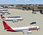
Googly scenery for VAAH Ahmedabad International, India - an enhancement to the airport provided in Flight Simulator 2004 which is incorrect in many respects. These scenery files correct and improve the terminal location, apron, taxiways, buildings and other airport features so that you and your "AI" traffic can land, taxi, park and take off in a realistic manner.
The airport is served by aircraft as large as Jumbo Jets from a range of domestic and international Indian airline operators, together with flights from other countries' airlines such as Kuwait Airways and Singapore Airlines.
The scenery does not purport to be ultra-accurate. Based on high-detail satellite imagery from Google Earth, the layout is proportionally correct but the added airport features, such as buildings, are built from default Microsoft objects and add-on libraries so will not look like the real thing.
You are not obliged to download and install any additional scenery libraries, but to enjoy this scenery in its entirety, you may wish to. It will work fine, with or without.
[File re-uploaded at request of AVSIM]
| Filename: | VAAH_Ahmedabad_International_India.zip |
| License: | Freeware |
| Added: | 26th June 2010, 06:06:36 |
| Downloads: | 2,923 |
| Author: | John Hinson |
| Size: | 82.47 KB |
| Category: Flight Simulator 2004 - Scenery | |
| FHSH - St. Helena Island & Airport - St. Helena, South Atlantic |
|
Images related to this file:
File Description:
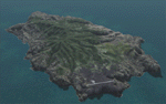
This project is a port of my FSX release of the the new airport (FHSH) on St. Helena Island. This scenery provides more accurate coastlines and roads, as well as corrected landclass based on the latest available satellite imagery. Flight plans are provided for the proposed commercial service to St. Helena, and some additional GA and military flights to the island are added as well.
The FS2004 St. Helena (FHSH) airport was created by aligning master plans for the airport with current satellite data and by studying many of the pictures that have been posted as the airport has taken shape. The official opening of the real airport on May 21, 2016, has been pushed back for more field tests due to challenging crosswinds. Updates were created or rebuilt in a manner which carefully aligns airport data with current satellite imagery. Scenery was created using Airport Design Editor 9 v1.67.5684 and SBuilder. Scenery objects were added and modified from stock FS9 scenery to resemble as closely as possible the actual airports.
| Filename: | FHSH__St_Helena_Island__Airport__St_Helena_South_A.zip |
| License: | Freeware |
| Added: | 5th May 2016, 07:44:38 |
| Downloads: | 2,238 |
| Author: | Carlyle Sharpe |
| Size: | 1.62 MB |
| Category: Flight Simulator 2004 - Scenery | |
| Funny Farm (4CA2) Brentwood, California Scenery |
|
File Description:
This is a scenery upgrade for Funny Farm Airport, Brentwood, California (4CA2) (Why Funny Farm?) This is part Nine of a series of small airstrip and minor airfield scenery enhancements which are based on real world data from Google Earth. The scenery mainly reflects the appearance of the airpark from directly above, so if you are familiar with the place then on the ground it probably looks quite different, due to the limited number of buildings available. This scenery includes the Private lake and dwellings to the southwest of the airstrip proper plus extensive landclass alterations to make the small paddocks in the same area. This is a tough place to land neatly in anything past a C172 in calm weather; the runway is only 20 feet wide! Built using EZ_Scenery, Lee Swordy's AFCAD and SBuilder. You must have rwy12 and EZ scenery libraries installed for the buildings to show. Both libraries of objects are free: EZ Library is available from http://www.abacuspub.com/pub/AbacusEZLibraries.exe and rwy12 and additional EZ Custom libraries from Avsim. Search under Scenery design.
| Filename: | Funny_Farm_4CA2_Brentwood_California_Scenery.zip |
| License: | Freeware |
| Added: | 1st April 2006, 23:42:42 |
| Downloads: | 549 |
| Author: | Kim Gowney |
| Size: | 359.43 KB |
| Category: Flight Simulator 2004 - Scenery | |
| MRE Mara Serena, Kenya |
|
File Description:
Googly scenery for Mara Serena, Kenya, a small airfield serving the Mara Serena
Safari Lodge in the Masai Mara National park. The original metalled runway has
fallen into disuse and these days a rough dirt runway alongside it is used by
the twice daily flights of Air Kenya Express to and from Nairobi and the
occasional light aircraft.
Flight Simulator 2004 has made no provision for traffic with only a runway
provided and this scenery seeks to redress the situation. The airport has no
ICAO code (MRE is the IATA code) but Microsoft Flight Simulator has created an
unofficial ICAO of HK0A.
The scenery does not purport to be ultra-accurate. Based on high quality
satellite imagery from Google Earth, the layout is proportionally correct but the
added airport features, such as buildings, are built from default Microsoft objects
and add-on libraries so will not look exactly like the real thing.
You are not obliged to download and install any additional scenery libraries,
but to enjoy this scenery in its entirety, you may wish to. It will work fine,
with or without.
| Filename: | MRE_Mara_Serena_Kenya.zip |
| License: | Freeware |
| Added: | 16th April 2008, 19:19:33 |
| Downloads: | 991 |
| Author: | John Hinson |
| Size: | 68.01 KB |
| Category: Flight Simulator 2004 - Original Aircraft | |
| North American F-86E/F Sabre |
|
Images related to this file:
File Description:
SECTIONF8 North-American F-86E/F 'slatted-wing' Sabre. A complete aircraft model, photoreal inside and outside, fully functional 2D panel and Dynamic VC, custom gauges and custom soundsuite, countless XML programmed goodies including droppable fuel tanks, automatic wing slats operation depending on speed and attitude, dynamic engine damage and flame-out simulation, authentic start-up procedure including fuel regulation and power cart, working guns with tracer bullets and muzzle flash effects, working ( or not working.... ) hydraulics system, parked mode with wheel chocks, fluttering RBF flags, in- and outlet covers, pilot flightgear on wing, etc., and so on.
This base package includes only two skin texture sets. Additional skin textures available with a seperate package 'sf86skns.zip', also available here. SECTIONF8 is a new FS add-on development team dedicated to produce almost every version and variant of the venerable F-86 Sabre including its seagoing sisters FJ-2, FJ-3, and FJ-4 Fury. More info at www.sectionf8.com.
| Filename: | North_American_F86EF_Sabre.zip |
| License: | Freeware, limited distribution |
| Added: | 26th October 2008, 15:08:59 |
| Downloads: | 39,767 |
| Author: | SECTIONF8: Jan Visser, Hansjoerg Naegele, Rob Young, Cliff Presley |
| Size: | 51.48 MB |
| Category: Flight Simulator 2004 - Scenery | |
| Sigonella AB - Sicily, Italy |
|
Images related to this file:
File Description:

Naval Air Station Sigonella, "The Hub of the Med", is a U.S. Navy installation at NATO Base Sigonella and an Italian Air Force base in Sicily, Italy. Although a tenant of the Italian Air Force, NAS Sigonella acts as landlord to more than 40 other U.S. commands and activities. It is located 15 km west and 11 km south of the city of Catania. Sigonella also serves as an Italian base for the 41º Stormo Antisom (41st Antisubmarine Warfare Wing). Among the aircraft that fly from this island base are U.S. Air Force C-130, C-17 and C-5 airlifters as well as KC refueling aircraft and a rotating squadron of forward-deployed U.S. Navy P-3 Orions. The Italian Air Force also fields the venerable Breguet Atlantic patrol aircraft. It is one of the most frequently used stops for U.S. airlift aircraft bound from the continental United States to Southwest Asia and the Indian Ocean. Scenery contains all new 3D models and AI aircraft. Package is stand-alone but additional downloads may be helpful (see docs for details).
| Filename: | Sigonella_AB__Sicily_Italy.zip |
| License: | Freeware, limited distribution |
| Added: | 3rd June 2014, 06:25:24 |
| Downloads: | 2,113 |
| Author: | John Stinstrom |
| Size: | 4 MB |
| Category: Prepar3D V1-4 - Scenery | |
| KLVN - Airlake Airport - Lakeville, MN, USA |
|
File Description:
KLVN - Airlake Airport beta version .4 - by Jason Boche
This is an update of the default P3Dv4.5 KLVN airport. Aside from the original 12/30 runway, everything else at this airport has been completely ripped and replaced.
Enhancements include:
-Extended runway on each end to depict current configuration
-Accurate taxiways including Hamburg Ave. and buildings representing the current general aviation hangars
-Added navigational equipment on the field
-Added a few asphault and dirt service roads
-Added FBO and other buildings as close as I could match them
-Added some general aviation aircraft, civilians, vehicles at the FBO and hangars, and two fuel trucks
-Moved fuel station to where I believe it is currently according to Google maps with 100LL fuel trigger functional
-Moved the windsock to accurate location
-Moved the beacon to accurate location
-Moved GA parking spots
-Added trees around FBO and beacon
-Added utility poles
-Added a few square miles of Lakeville city, farm, and residential land class and autogen according to Google maps. This is probably the biggest improvement. It now looks like people live, work, and shop north/northwest of KLVN.
-Reworked the runway 12/30 blast pads to what I believe is the "proper" method. Instead of freehand polygon asphault, they are now actual runway extensions on both ends with yellow chevron markings
-Reworked the land class on the southwest end of the airport where I believe hangar expansion is intended. Prior to this, there was a sharp contrast between where the KLVN airport boundary ended and where generic farm landclass began which was right in the middle of the southwest taxiways and it looked bad. Now that whole region is grass and looks to be part of the airport parcel.
-Minor building adjustments west of the FBO to better match actual placement.
-Fixed a gap on the southeast end of Hamburg ave taxiway where it rounds the corner for the rwy 30 hold short line
-Randomized the directional facing of some of the cars parked at GA hangars
-Renumbered the parking spots 1-4 with #5 being the refueling spot
-Reversed the start direction of parking spots 1-3.
-Pulled the refueling parking "start" spot back because on start the engine cowling & prop were too far forward inside the fuel pump equipment
-Added an autogen exclusion to the rwy 12 short final due to trees popping up on short final path.
-KLVN tower viewpoint 25 meters above FBO.
-Removed the perimeter fence around the entire field
| Filename: | KLVN__Airlake_Airport__Lakeville_MN_USA.zip |
| License: | Freeware |
| Added: | 13th May 2020, 17:18:40 |
| Downloads: | 84 |
| Author: | Jason Boche |
| Size: | 14.81 KB |
| Category: Flight Simulator X - AFCAD Files | |
| KLVN - Airlake Airport - Lakeville, MN, USA |
|
File Description:
KLVN - Airlake Airport beta version .3 - by Jason Boche
This is an update of the default FSX KLVN airport. Aside from the original 12/30 runway, everything else at this airport has been completely ripped and replaced.
Enhancements include:
-Extended runway on each end to depict current configuration
-Accurate taxiways including Hamburg Ave. and buildings representing the current general aviation hangars
-Added navigational equipment on the field
-Added a few asphault and dirt service roads
-Added FBO and other buildings as close as I could match them
-Added some general aviation aircraft, civilians, vehicles at the FBO and hangars, and two fuel trucks
-Moved fuel station to where I believe it is currently according to Google maps with 100LL fuel trigger functional
-Moved the windsock to accurate location
-Moved the beacon to accurate location
-Moved GA parking spots
-Added trees around FBO and beacon
-Added utility poles
-Added a few square miles of Lakeville city, farm, and residential land class and autogen according to Google maps. This is probably the biggest improvement. It now looks like people live, work, and shop north/northwest of KLVN.
-Reworked the runway 12/30 blast pads to what I believe is the "proper" method. Instead of freehand polygon asphault, they are now actual runway extensions on both ends with yellow chevron markings
-Reworked the land class on the southwest end of the airport where I believe hangar expansion is intended. Prior to this, there was a sharp contrast between where the KLVN airport boundary ended and where generic farm landclass began which was right in the middle of the southwest taxiways and it looked bad. Now that whole region is grass and looks to be part of the airport parcel.
-Minor building adjustments west of the FBO to better match actual placement. Will only be shown on high scenery detail.
-Fixed a gap on the southeast end of Hamburg ave taxiway where it rounds the corner for the rwy 30 hold short line
-Randomized the directional facing of some of the cars parked at GA hangars
-Renumbered the parking spots 1-4 with #5 being the refueling spot
-Reversed the start direction of parking spots 1-3.
-Pulled the refueling parking "start" spot back because on start the engine cowling & prop were too far forward inside the fuel pump equipment
-Added an autogen exclusion to the rwy 12 short final due to trees popping up on short final path.
-KLVN tower viewpoint 25 meters above FBO.
-Removed the perimeter fence around the entire field
| Filename: | KLVN__Airlake_Airport__Lakeville_MN_USA.zip |
| License: | Freeware |
| Added: | 22nd November 2013, 23:26:10 |
| Downloads: | 226 |
| Author: | Jason Boche |
| Size: | 446.33 KB |


© 2001-2026 AVSIM Online
All Rights Reserved
Privacy Policy |