
Where Flight Simulation Enthusiasts Gather from Around the World!
AVSIM Library - Search Results

| Category: Flight Simulator 2004 - Scenery | |
| MRE Mara Serena, Kenya |

|
File Description:
Googly scenery for Mara Serena, Kenya, a small airfield serving the Mara Serena
Safari Lodge in the Masai Mara National park. The original metalled runway has
fallen into disuse and these days a rough dirt runway alongside it is used by
the twice daily flights of Air Kenya Express to and from Nairobi and the
occasional light aircraft.
Flight Simulator 2004 has made no provision for traffic with only a runway
provided and this scenery seeks to redress the situation. The airport has no
ICAO code (MRE is the IATA code) but Microsoft Flight Simulator has created an
unofficial ICAO of HK0A.
The scenery does not purport to be ultra-accurate. Based on high quality
satellite imagery from Google Earth, the layout is proportionally correct but the
added airport features, such as buildings, are built from default Microsoft objects
and add-on libraries so will not look exactly like the real thing.
You are not obliged to download and install any additional scenery libraries,
but to enjoy this scenery in its entirety, you may wish to. It will work fine,
with or without.
| Filename: | MRE_Mara_Serena_Kenya.zip |
| License: | Freeware |
| Added: | 16th April 2008, 19:19:33 |
| Downloads: | 988 |
| Author: | John Hinson |
| Size: | 68.01 KB |
| Category: Flight Simulator 2004 - Scenery | |
| YEVD Evans Head Memorial, Australia |
|
File Description:
Googly scenery for YEVD Evans Head Memorial, a former RAAF Training base in
New South Wales, Australia, now reduced to a single runway and small apron.
In its heyday it was home to the RAAF No 1 Bombing and Gunnery and the RAAF No 1
Air Observers Schools and it was said to be the largest training base in the
southern hemisphere - at that time it had four runways.
Flight Simulator 2004 has made no provision for traffic with only a runway
provided and this scenery seeks to redress the situation so that you and your
"AI" traffic can use the airport.
The scenery does not purport to be ultra-accurate. Based on high quality
satellite imagery from Google Earth, the layout is proportionally correct but the
added airport features, such as buildings, are built from default Microsoft objects
and add-on libraries so will not look exactly like the real thing.
You are not obliged to download and install any additional scenery libraries,
but to enjoy this scenery in its entirety, you may wish to. It will work fine,
with or without.
| Filename: | YEVD_Evans_Head_Memorial_Australia.zip |
| License: | Freeware |
| Added: | 19th April 2008, 10:23:02 |
| Downloads: | 544 |
| Author: | John Hinson |
| Size: | 71.78 KB |
| Category: Flight Simulator 2004 - Scenery | |
| Grafton District Airport - NSW Australia |
|
File Description:
A delighful small airport approximately 80 nautical miles from Coffs Harbour and a slightly shorter distance to Ballina and Lismore. This makes a good stopover for hopping down the east coast of Australia.
The size of the airport has allowed me to put in that extra detail which makes to terminal and surrounds very much "as in real life". Photographic textures are used throughout for the buildings and even the trees are hand made macros from photographs at the airport.
AFCAD and Traffic Tools files are included to add extra AI traffic. For that reason and because of limited apron space no static planes have been used.
The scenery concentrates on adding a realistic terminal to the airport whilst leaving much of the default runway detail unchanged. Changes which have been made to the runway include tidying up the taxi way fillets so the markings do not appear to be on the grass and the windsocks have been replaced with macros designed to resemble the Grafton windsocks. Other than that the airport merges into the default scenery without the usual "green oasis" effect.
| Filename: | Grafton_District_Airport__NSW_Australia.zip |
| License: | Freeware, limited distribution |
| Added: | 5th December 2003, 04:29:01 |
| Downloads: | 2,546 |
| Author: | John Ross |
| Size: | 2.1 MB |
| Category: Prepar3D V1-4 - Scenery | |
| Charleroi Brussels South EBCI2022 Early Release |
|
File Description:
This is the latest update of the EBCI2016 scenery previously published.
It only features default buildings and objects but creates the whole "new" terminal area (north of the runway, since 2008 but not implemented by default on FSX & P3D), and it also features the extension of the runway and additional taxiways as of December 2021.
This scenery should work on FSX and P3D all versions. However please be kind reporting any issues you see.
It is an early release, allowing you to benefit the new infrastructure and the longer runway. However, expect later in 2022 a fully redesigned scenery, closer to the reality.
MAIN FEATURES:
- current accurate runway + all taxiways
- runway and taxiway lighting according to real life
- DME added to the ILS 110.900 IGC
- All parking stands at the north (51 to 72 + "far-away" stands + B stands for code D and A340)
- parking numbers (may fail to show up sometimes)
INSTALL:
Put the main folder in your ADDON SCENERY and add it to the library (like most sceneries).
Enjoy!
| Filename: | Charleroi_Brussels_South_EBCI2022_Early_Release.zip |
| License: | Freeware |
| Added: | 5th January 2022, 00:21:50 |
| Downloads: | 404 |
| Author: | IVAO Belux / Jonatan G. |
| Size: | 556.32 KB |
| Category: Flight Simulator 2004 - Scenery | |
| DTTR El Borma, Tunisia |
|
File Description:
Googly scenery for El Borma (ICAO: DTTR, IATA: EBM), a small airport with a
long runway deep in the Tunisian desert near the Algerian border. El Borma,
also known as Al Borma or Al Burmah is one of Tunisia's top onshore oil and
natural gas sources and it is this that probably justifies the twice-weekly
flights operated by ATR turboprops of Sevenair.
Microsoft have only provided runways at this airport in Flight Simulator
2004 and this scenery seeks to redress the situation so that you and your
"AI" traffic can use the airport realistically.
The scenery does not purport to be ultra-accurate. Based on high quality
satellite imagery from Google Earth, the layout is proportionally correct but the
added airport features, such as buildings, are built from default Microsoft objects
and add-on libraries so will not look exactly like the real thing.
You are not obliged to download and install any additional scenery libraries,
but to enjoy this scenery in its entirety, you may wish to. It will work fine,
with or without.
| Filename: | DTTR_El_Borma_Tunisia.zip |
| License: | Freeware |
| Added: | 17th December 2008, 16:49:15 |
| Downloads: | 1,027 |
| Author: | John Hinson |
| Size: | 58.32 KB |
| Category: Flight Simulator 2004 - Scenery | |
| VAAH Ahmedabad International, India |
|
Images related to this file:
File Description:

Googly scenery for VAAH Ahmedabad International, India - an enhancement to the airport provided in Flight Simulator 2004 which is incorrect in many respects. These scenery files correct and improve the terminal location, apron, taxiways, buildings and other airport features so that you and your "AI" traffic can land, taxi, park and take off in a realistic manner.
The airport is served by aircraft as large as Jumbo Jets from a range of domestic and international Indian airline operators, together with flights from other countries' airlines such as Kuwait Airways and Singapore Airlines.
The scenery does not purport to be ultra-accurate. Based on high-detail satellite imagery from Google Earth, the layout is proportionally correct but the added airport features, such as buildings, are built from default Microsoft objects and add-on libraries so will not look like the real thing.
You are not obliged to download and install any additional scenery libraries, but to enjoy this scenery in its entirety, you may wish to. It will work fine, with or without.
[File re-uploaded at request of AVSIM]
| Filename: | VAAH_Ahmedabad_International_India.zip |
| License: | Freeware |
| Added: | 26th June 2010, 06:06:36 |
| Downloads: | 2,921 |
| Author: | John Hinson |
| Size: | 82.47 KB |
| Category: Flight Simulator 2004 - Scenery | |
| Howick Airfield (FAHC), South Africa |
|
Images related to this file:
File Description:
This package will add a custom (Gmax) made Howick Airfield (FAHC), KwaZulu Natal, South Africa with photoreal textures and seasonal ground textures.
Howick is a small town in the KwaZulu Natal Midlands just off the N3 freeway which connects Johannesburg and Durban and home to the famous Howick waterfall. The Umgeni river falls 95m (311 ft) over the cliffs on the way to the Indian Ocean. The town is also home to the Midmar dam. This dam is very well known as being the location of the annual Midmar Mile swimming event which, in 2009, was recognized by the Guinness Book of World Records as the world's largest open water swimming event with 13 755 competitors taking part.
The sloped grass runway is aligned 16/34 and 825m long and sits at an elevation of 3 615ft. Both runways have obstacles on the approach, with powerlines 730m from the threshold of runway 16, while runway 34's approach have hills around 900m before the threshold. The sloped runway has been created in FS2004 within the limits of the simulator itself.
| Filename: | Howick_Airfield_FAHC_South_Africa.zip |
| License: | Freeware, limited distribution |
| Added: | 15th January 2021, 20:25:51 |
| Downloads: | 201 |
| Author: | Kobus van Wyk |
| Size: | 7.67 MB |
| Category: Flight Simulator X - Scenery | |
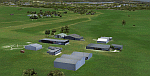
| FSX Portland International Airport KPDX |
|
Images related to this file:
File Description:
Welcome to Portland International Airport for FSX!
The City of Roses is in the process of revamping KPDX. Many of us have spent time on Concourse A
waiting for our Horizon flight. Many have utilized the ground level walkways on Concourse E to
get to their United Express flight. Both are things of the past.
KPDX is now a primary Alaska Airlines hub. This summer British Airways will start service to London
Heathrow.
The runways have been adjusted to their current length. The taxiways have been corrected (this is
particularly important at the juncture of 10L and 21 which used to overlap). A copy of the current
airport diagram is included.
All the buildings (with the exception of the tower) are custom. Airport vehicles use
the proper vehicle paths and do not use taxiways.To achieve this I had to add a vehicle path that crosses
10R and another that crosses 03.
Three scenery complexity levels are used (normal,dense, and very dense). More eye candy appears with each
increase.
| Filename: | FSX_Portland_International_Airport__KPDX.zip |
| License: | Freeware, limited distribution |
| Added: | 15th January 2020, 05:01:47 |
| Downloads: | 1,785 |
| Author: | Brett Delana |
| Size: | 12.18 MB |
| Category: Prepar3D V1-4 - Scenery | |
| Singapore Changi Airport (WSSS) for P3D V4 |
|
Images related to this file:
File Description:
Singapore Changi Airport (WSSS) for P3D V4. By Zenith Creations (Zachary Tay). This add-on is the culmination of over a year’s worth of work on various aspects of the airport. The scope has increased tremendously, from merely an amendment of the taxi signs to new 3-D models and various airport landmarks, as well as satellite imagery for the airport area. A basic GSX configuration is also included, subject to change in future. You need SODE for the jetways, it's free. Features: - Phase IV compliant taxi signs, correct as of 23/12/2021 - Custom terminal, satellite imagery, tower and Jewel objects - SODE jetways - Apron lighting Known issues: - 02R/20L signs are incomplete - Models are very basic and could use improvement I hope you'll enjoy this improvement over the default WSSS, and Merry Christmas. If you have questions or suggestions, send an email to [email protected]. And if you'd like to support my work, please consider donating to my Patreon, at www.patreon.com/zenithcreations, or my PayPal, username exocetfalling. REUSE: Licensed under Creative Commons BY-SA 4.0.
| Filename: | Singapore_Changi_Airport_WSSS_for_P3D_V4.zip |
| License: | Freeware |
| Added: | 26th December 2021, 17:08:57 |
| Downloads: | 1,229 |
| Author: | Zachary Tay |
| Size: | 130.25 MB |
| Category: Flight Simulator 2004 - Scenery | |
| Gang Ranch CAY2 in British Columbia Canada |
|
Images related to this file:
File Description:
Gang Ranch is on the eastern side of the Coast Mountains of British Columbia, around 50 miles west of Green Lake and 5 miles west of the Fraser River that runs north-south at that latitude (51 degrees 30 minutes north, in round figures). The airfield is among some farm fields and difficult to spot (this will depend on your personal textures and settings) and the ranch buildings are scattered and a mile or two away, the nearest being the owner's house. The runway is gravel, only 1,800 feet long and aligned 08-26 at 2,150 feet above sea level. There is no lighting. I have posted it as Gang Ranch CAY2, but I suggest that you just add it to your previously created "BC airfields" (if you did that) and avoid the inevitable doubling up of common textures etc. Plus that way you will have just one FS9 library post to do and new airfields will not need yet another posting. Up to you. If you find a defect, email me.
| Filename: | Gang_Ranch_CAY2_in_British_Columbia_Canada.zip |
| License: | Freeware, limited distribution |
| Added: | 19th November 2020, 19:44:55 |
| Downloads: | 100 |
| Author: | Roger Wensley |
| Size: | 8.98 MB |
© 2001-2026 AVSIM Online
All Rights Reserved
Privacy Policy |