
Where Flight Simulation Enthusiasts Gather from Around the World!
AVSIM Library - Search Results

| Category: Flight Simulator X - Scenery | |
| County Class Destroyers |

|
Images related to this file:
File Description:
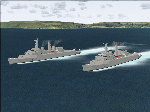
County Class Destroyers. Helicopter landable, provided in both static and AI form. Two versions are provided, Batch 1 with two 4.5in twin turrets, Sea Slug missiles, Sea Cat missiles and two 20mm Oerlikon, and Batch 2 conversion with Exocet in lieu of one turret.
Can be used alone or as escort to an Aircraft Carrier.
Both are provided with and without wake.
By Mike Hudson
| Filename: | County_Class_Destroyers.zip |
| License: | Freeware |
| Added: | 7th September 2011, 22:20:38 |
| Downloads: | 524 |
| Author: | Mike Hudson |
| Size: | 9.99 MB |
| Category: Flight Simulator 2004 - Scenery | |
| Boundary County 65S |
|
File Description:
Another airport located in the beautiful mountains of northern Idaho. This scenery is based on aerial photos from Google Earth and other sources. All default buildings have been replaced and new taxiways and buildings have been added. (I couldn't find any information on the taxiway designations, so I made them up.) Some general aviation AI traffic is included.
| Filename: | Boundary_County_65S.zip |
| License: | Freeware |
| Added: | 12th May 2008, 23:30:25 |
| Downloads: | 653 |
| Author: | Sidney Schwartz |
| Size: | 858.23 KB |
| Category: Flight Simulator 2004 - Scenery | |
| KILM - Wilmington International Airport - Wilmington, North Carolina (USA) |
|
Images related to this file:
File Description:
FS2004/FSX Scenery - Wilmington International Airport (IATA: ILM, ICAO: KILM, FAA LID: ILM) is a public airport located just north of Wilmington, North Carolina, in unincorporated Wrightsboro, Cape Fear Township, New Hanover County. This scenery consists of the terminal area only. The rest of the airport is all default. This is the only download you will need for the scenery to work. Created by John B. Loney, Jr.
| Filename: | KILM__Wilmington_International_Airport__Wilmington.zip |
| License: | Freeware, limited distribution |
| Added: | 16th August 2013, 21:02:32 |
| Downloads: | 819 |
| Author: | John B. Loney, Jr. |
| Size: | 5.07 MB |
| Category: Flight Simulator X - AFCAD Files | |
| Aspen-Pitkin County/Sardy Field (KASE) |
|
File Description:
This scenery update is for Aspen-Pitkin County airport. Located high in the Rocky Mountains, Aspen is known for it's challenging high altitude runway 15 approach. It updates various aspects of the airport, including taxiways, runways, and parking. Real world demensions were used through Google Earth. A few objects form the default FSX libraries were also added. View Readme file for installation and notes. Compiled using Airport Design Editor.
| Filename: | AspenPitkin_CountySardy_Field_KASE.zip |
| License: | Freeware |
| Added: | 5th June 2008, 20:12:14 |
| Downloads: | 1,157 |
| Author: | Phillip Coyle |
| Size: | 286.85 KB |
| Category: Flight Simulator X - Scenery | |
| KPEO - Penn Yan Airport - Penn Yan, NY |
|
Images related to this file:
File Description:
Here is an improved version of the stock Penn Yan Airport. I adjusted aprons, taxiways and added roads to match the actual airport. I replaced every default building, added static vehicles, aircraft and other objects. Adjusted the boundary fence and made cuts where the fence crossed roads.
Penn Yan Airport is located on the shore of Keuka Lake, is owned by Yates County, and is home to Seneca Flight Operations.
| Filename: | KPEO__Penn_Yan_Airport__Penn_Yan_NY.zip |
| License: | Freeware |
| Added: | 7th December 2009, 10:37:29 |
| Downloads: | 603 |
| Author: | Jim Cook |
| Size: | 7.71 KB |
| Category: Flight Simulator X - Scenery | |
| KPSK - New River Valley Airport - Dublin, Virginia |
|
File Description:
New River Valley Airport is a public use airport located two nautical
miles (4 km) north of the central business district of Dublin, in
Pulaski County, Virginia, United States. It is owned by the New River
Valley Airport Commission.
The facility serves primarily general aviation, but is also an
official U.S. Customs Service port of entry as of 2006.
Adjusted taxiways and added lights. Includes custom terminal and
hangers.
| Filename: | KPSK__New_River_Valley_Airport__Dublin_Virginia.zip |
| License: | Freeware |
| Added: | 3rd February 2013, 20:56:43 |
| Downloads: | 506 |
| Author: | Wayne Roberts |
| Size: | 807.37 KB |
| Category: Flight Simulator X - Aircraft Repaints, Textures and Modifications | |
| Wake Forest Baptist University EC135 |
|
Images related to this file:
File Description:
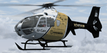
North Carolina Baptist Hospital at Wake Forest University flies one Eurocopter EC135 Helicopter operated by Air Methods. This file contains textures for "Air Care 1" (N243AM) based at the Davidson County Airport (KEXX) in Lexington, NC. Requires the Nemeth Designs EC135 (Payware). Textures by Bradley Bormuth.
| Filename: | Wake_Forest_Baptist_University_EC135.zip |
| License: | Freeware |
| Added: | 18th October 2012, 02:51:53 |
| Downloads: | 202 |
| Author: | Bradley Bormuth |
| Size: | 1.4 MB |
| Category: Flight Simulator X - Scenery | |
| Bellefonte Airport N96 |
|
Images related to this file:
File Description:
FSX Scenery - Bellefonte Airport (N96) serves Bellefonte and Centre County and is owned by John & Marina Elnitski. The paved runway extends for 3600 feet. The facility is at an elevation of 1080 feet at a distance of about 3 miles from Bellefonte. By John B. Loney, Jr.
| Filename: | Bellefonte_Airport_N96.zip |
| License: | Freeware, limited distribution |
| Added: | 27th February 2011, 04:40:55 |
| Downloads: | 365 |
| Author: | John B. Loney, Jr. |
| Size: | 1.69 MB |
| Category: Flight Simulator X - Scenery | |
| W29 - Bay Bridge Airport - Stevensville, Maryland - USA |
|
Images related to this file:
File Description:
FSX Scenery - Bay Bridge Airport (FAA LID: W29) is a county-owned public-use airport located in Stevensville, Maryland.The airport is named for the nearby Chesapeake Bay Bridge and is mostly used for general aviation. Bay Bridge Airport covers an area of 72 acres (29 ha) and contains one asphalt runway (11/29) measuring 2,903 x 60 ft (885 x 18 m). Non-default AI repaints/traffic available by John Burford. Scenery created by John B. Loney, Jr.
| Filename: | W29__Bay_Bridge_Airport__Stevensville_Maryland__US.zip |
| License: | Freeware, limited distribution |
| Added: | 18th November 2014, 14:54:33 |
| Downloads: | 474 |
| Author: | John B. Loney, Jr. |
| Size: | 8.2 MB |
| Category: Flight Simulator 2004 - Scenery | |
| W29 - Bay Bridge Airport - Stevensville, Maryland - USA |
|
Images related to this file:
File Description:
FS2004 Scenery - Bay Bridge Airport (FAA LID: W29) is a county-owned public-use airport located in Stevensville, Maryland.The airport is named for the nearby Chesapeake Bay Bridge and is mostly used for general aviation. Bay Bridge Airport covers an area of 72 acres (29 ha) and contains one asphalt runway (11/29) measuring 2,903 x 60 ft (885 x 18 m). Non-default AI repaints/traffic available by John Burford. Scenery created by John B. Loney, Jr.
| Filename: | W29__Bay_Bridge_Airport__Stevensville_Maryland__USA.zip |
| License: | Freeware, limited distribution |
| Added: | 18th November 2014, 14:58:27 |
| Downloads: | 294 |
| Author: | John B. Loney, Jr. |
| Size: | 8.02 MB |


© 2001-2026 AVSIM Online
All Rights Reserved
Privacy Policy |