
Where Flight Simulation Enthusiasts Gather from Around the World!
AVSIM Library - Search Results

| Category: Flight Simulator 2004 - Scenery Design | |
| SBuilder 2.05 |

|
File Description:
SBuilder produces almost all type of scenery for FS2004 such as: Mesh Scenery, Land and Water Class Scenery, Standard and High Resolution Photo Scenery, LWM and VTP Scenery, Exclusion Scenery and Object Placement (FS8 and FS9 Library Objects, API and ASD macros and Rwy12 Objects). SBuilder reads default BGL files (LWM and VTP types) and GIS files (lines, polygons and points of interest). It has also some other capacities as Re-Projection of Raster or Vector files.
| Filename: | SBuilder_205.zip |
| License: | Freeware |
| Added: | 9th May 2005, 07:06:40 |
| Downloads: | 16,058 |
| Author: | Luis Sá |
| Size: | 2.84 MB |
| Category: Flight Simulator X - Scenery | |
| RAF Bottlesford - Lincolnshire, England |
|
File Description:
Royal Air Force Station Bottesford or more simply RAF Bottesford is a former Royal Air Force station located on the Leicestershire-Lincolnshire county border, 6.8 miles (10.9 km) north west of Grantham, Lincolnshire and 7.6 miles (12.2 km) south of Newark-on-Trent, Nottinghamshire and about 107 miles (172 km) north-northwest of London, England.
Opened in 1942, it was used by both the Royal Air Force (RAF) and United States Army Air Forces (USAAF). During the war it was used primarily as a troop carrier airfield for paratroopers and as a bomber airfield before closing in 1948.
Today the remains of the airfield are located on private property with the technical site being used as an industrial estate.
Third party add-on's will be required to see all the building included in the scenery, you will need Ted Andrews RAF Small Buildings and his hanger library, for the vehicles Ian Pearson FSX Object library will be required, the RAF Ensign hedges are the from Mike Hudson's scenery. All of which are available from Ian Pearsons' website; www.ianpsdarkcorner.co.uk.
| Filename: | RAF_Bottlesford___Lincolnshire_England.zip |
| License: | Freeware |
| Added: | 10th October 2015, 11:37:40 |
| Downloads: | 345 |
| Author: | Terry Boissel |
| Size: | 15.94 KB |
| Category: Flight Simulator 2004 - Miscellaneous Files | |
| DHC-2 Beaver Smoke With Control Gauge |
|
File Description:
This xml gauge and effect package automatically controls the light smoke effect in the DHC-2 Beaver by simply accelerating the throttle. The DHC-2 Beaver will automatically emit a very light smoke effect at a Manifold Pressure reading of 32(+) or greater, depicting a hard running engine. Reducing the throttle level for cruising (MP30-32) or less for descents deactivates the smoke effect.
Even though this xml gauge and effect file works perfectly well by itself, when used in conjunction with my dhc2_fx.zip, all the bases are covered. Smoke automatically engages for cold air temps and with this xml gauge, smoke engages as a result of high manifold pressure (eg. when taking off or climbing). The two work together very nicely without any conflict.
Designed for the FS2004 DHC-2 wheeled Beaver by Steven Grant, Fred Choate, and Aaron Swindle. In the AVSIM library-- dhc2_04w.zip --
Also works with the DHC-2 De Havilland Beaver Amphibian v2 that was made for FS2002, but works equally well in FS2004. In the AVSIM library-- dhc2ampv2.zip --
The README file includes complete instructions.
| Filename: | DHC2_Beaver_Smoke_With_Control_Gauge.zip |
| License: | Freeware |
| Added: | 7th October 2003, 16:34:19 |
| Downloads: | 1,767 |
| Author: | Brent Hricziscse |
| Size: | 5.31 KB |
| Category: Flight Simulator 2004 - Utilities | |
| TreePlanter V4.1 |
|
File Description:
FS 2004 autogen will not be displayed in close proximity to an airport due to the associated airport exclude. GianP ( http://home.tele2.it/gianp ) has produced a library of ‘autogen-like’ trees which use either the default or Gerrish Gray's textures which can be placed near to an airport. The trees must be placed using XML code which is compiled into a scenery bgl by the BGLComp compiler from the FS 2004 BGL Comp SDK. TreePlanter automates this task by interfacing directly with FS 2004 to obtain the required position of each tree and generating the scenery bgl automatically. This updated TreePlanter includes a further 20 tree types by GianP using Gerrish Gray's textures. It also allows the 'p' key on the keyboard to be used to plant trees rather than needing to click on a button with the mouse. It also requires a new library from GianP's site and Gerrish Gray's textures.
An error in one of the Gerrish Gray tree selector has been corrected and the restriction on the use of spaces in filenames has been removed.
| Filename: | TreePlanter_V41.zip |
| License: | Freeware |
| Added: | 22nd February 2005, 22:33:33 |
| Downloads: | 4,907 |
| Author: | George Davison |
| Size: | 892.58 KB |
| Category: Flight Simulator 2004 - Scenery | |
| Tel Aviv Lod Airport Scenery 1961 |
|
File Description:
Lod Airport, now called Ben Gurion International Airport started out in 1936 as Lydda Airport, an airstrip of four concrete runways on the outskirts of the Arab town of Lydda. By the mid-1960s, 14 international airlines were landing at Lod Airport.
I have backdated Lod airport back to 1961, when it was much smaller than today. Lod was and is Tel Aviv's major airport, used for all airline flights in 1961, and most international flights today. I have used GMAX to create the terminal and many of the hangars and other buildings at the airport, and have also used many library objects to increase the detail around the airport. Landclass files are included to reduce the city area back to their sizes in the 1960's. I have also backdated 4 other airports: Eilath (LLET), Sde Dov (LLSD), Mahanaim (LLIB), and Beer Sheeba (Teyman LLBS). These use library objects to increase the airport detail as well. These cities constituted the entire route network of Arkia, the local airline of Israel, in 1961.
| Filename: | Tel_Aviv_Lod_Airport_Scenery_1961.zip |
| License: | Freeware, limited distribution |
| Added: | 30th October 2008, 20:30:22 |
| Downloads: | 2,844 |
| Author: | Mike Stevens |
| Size: | 699.82 KB |
| Category: Flight Simulator X - Scenery | |
| NZOP- Opotiki Aerodrome (VectorLandClass, New Zealand) |
|
Images related to this file:
File Description:
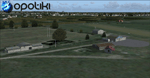
Opotiki aerodrome (ICAO: NZOP) is a small airstrip outside the township of of Opotiki, the gateway to the beautiful East coast of the North Island of New Zealand. Opotiki itself sits at the confluence of the Waioeka and Otara rivers and is surrounded by dairy farmland and Kiwifruit orchards with large areas of native bush to the south and east.
This scenery accompanies Tim Barnes'�� series of other small Bay of Plenty aerodromes (Whakatane,
Galatea, Waihi Beach) for use with VectorLandClass- It features custom modelled and textured buildings, large coverage of beautiful 0.5m aerial photography (fully auto-genned and including seasonal and night variations) and extensive use of high quality objects from the free VLC library. Installation of the library V1.1+ is required for this scenery to work properly and can be downloaded from the VectorLandClass website (www.vectorlandclass.co.nz)
This release, although not requiring it, works best with VectorLandClass topographic mesh and landclass addon covering all 268676 square kilometers of New Zealand. If you'��re not a VLC customer, you'��ll notice when the photoreal coverage runs out!
| Filename: | NZOP_Opotiki_Aerodrome_VectorLandClass_New_Zealand.zip |
| License: | Freeware, limited distribution |
| Added: | 21st February 2013, 13:52:47 |
| Downloads: | 969 |
| Author: | Tim Barnes |
| Size: | 146.68 MB |
| Category: Flight Simulator 2004 - Scenery | |
| VFR of Lario, Area E2 - Como Lake, Italy (Update) |
|
Images related to this file:
File Description:
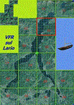
This 8th scenery covers approximately an area of 7.5x6 km, from S.Gregorio/Dongo (NW) to Colico (NE), and S.Siro (SW) to Tremenico/Aveno (SE) and includes six NLC piers: Dervio, Piona, Colico, Dongo, Musso, Pianello del Lario, in addition to the disused Cremia's one; a lot of dedicated buildings are included, as S.Tommaso of Canterbury church and fortification (Corenno), Cistercian abbey (Piona), pier and dock (Colico), S.Stefano church, factory buildings and airpollution control machinery (Dongo), Rezzonico's castle (S.Siro).
This VFR on Lario scenery includes several Dervio's details, and fully revises the previous Dervio scenery; Are included: Boldona's park office and stand, railway station, NLC shiphard, Pontile piers with Concordia steamer, dock bay with small floating pier and compass of the lake, S. Peter and Paul church and houses front of lake, hydro power station, Municipality and some other buildings, Castello's tower, windsurf school, windsurfers and kitesurfers on the lake, cross and Madonna on top of Legnoncino mountain. There are also included two viaducts between the tunnels of the freeway 36, with moted traffic. Catamarans Citta di Como and Tivano at Colico/Dongo piers together with other minor boats and docks alongside the lake coast; a moted regata with catamarans is placed in the lake between Pianello and Dervio.
This scenery SUPERSEDES AND CANCELS the previous "dervio_v2a" one, removed from the library. This is the eighth scenery of the "VFR of Lario" project, made with photorealistic terrain (multiseason & night) and with some 3D GMax realistic objects.
| Filename: | VFR_of_Lario_Area_E2__Como_Lake_Italy_Update.zip |
| License: | Freeware |
| Added: | 25th November 2012, 20:54:39 |
| Downloads: | 1,664 |
| Author: | Aldo Della Vedova, Daniele Lanfranchi, Gian Mario Verga |
| Size: | 39.39 MB |
| Category: Flight Simulator X - Scenery | |
| KAFW Fort Worth Alliance Airport - Texas, US |
|
Images related to this file:
File Description:
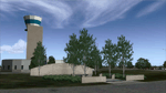
Ft. Worth Alliance Airport opened in 1989 and was billed as the world's first purely industrial airport. It is located around 14 miles North of the central business district of Ft. Worth and is also nearby the Dallas/Ft. Worth International Airport (KDFW). The airport serves general aviation, corporate jet, cargo, and military air traffic on a daily basis and it's proximity to the Texas Motor Speedway (only a few miles) brings extra dense traffic on race weekends. The airport is home to the American Airlines 777 and 767 maintenance base, FedEx Southwest Regional Sort Hub, Bell-Helicopter Training Center, DEA Air Operations Center and DynCorp International. Sadly the American Airlines maintenance base is set to close at the end of 2012 but is being kept alive in FSX!
This scenery features custom 3d buildings and objects bringing you a very accurate rendition of Ft. Worth Alliance Airport. Requires FSX Acceleration for the all scenery objects to display correctly.
Note: These files MUST be installed for the scenery to work correctly (otherwise there will be missing scenery objects at the airport):
-Filename: fsx_lts.zip - Ramp Lighting for FSX by Jim Dhaenens
-Filename: dlfcorelibraries2fsx.zip - Dan French Core Library Vol. 2
-Filename: lightstoo.zip - Jim Dhaenens Airfield Lighting
-Filename: objlib-jgse-fsx.zip - John Stinstrom JGSE Yellow Objects - this newer file replaces the older FS9 libraries with FSX versions
-Filename: objlib-ggse-fsx.zip - John Stinstrom GGSE Green Objects - this file also replaces FS9 libraries with FSX versions
| Filename: | KAFW_Fort_Worth_Alliance_Airport__Texas_US.zip |
| License: | Freeware, limited distribution |
| Added: | 12th December 2012, 16:56:36 |
| Downloads: | 2,932 |
| Author: | Brandon Thetford |
| Size: | 439.24 MB |
| Category: Prepar3D V1-4 - Scenery | |
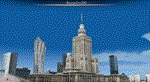
| Warsaw City X DEMO |
|
Images related to this file:
File Description:
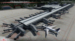
WARSAW CITY X DEMO is a sophisticated scenery package, featuring a detailed scenery of Warsaw city in Poland with surrounding airports, fully compatible with P3Dv1, P3Dv2 and P3Dv3.
This product is a fully functional DEMO version of the commercial payware product. It features same layouts as in the full version but with limited 3D objects and low resolution textures. Using this free demo ensures no problems with online (VATSIM, IVAO, multiplayer etc.) flying in case some users use the payware scenery and some don't.
Warsaw is the capital and the largest city of Poland located on the Vistula (Wisla) River. Warsaw City 2015 gives you a possibility to fly over an extremely large area of Warsaw city. We have included a photoreal ground textures of about 5200 square km. The city centre has hundreds of custom buildings modeled, there are all VFR-important landmarks on the whole included area too. We have also created 13 variously detailed airports and heliports for the project: Modlin EPMO, Babice EPBC, Chrcynno/Nasielsk, Sobienie EPSJ, Goraszka EPGO, Konstancin-Jeziorna, Konstancin Heliport, Reczaje (lite), Kroczewo (lite), Trebki Nowe (lite), Wincentow 1 (lite), Wincentow 2 (lite), Zabia Wola (lite).
The product is equipped with an automatic installer, which means that the scenery will be automatically added to the Flight Simulator Scenery Library. Please uninstall all previous versions of similar sceneries you may have installed before. Please make also sure that no duplicate AFCAD files are installed.
Enjoy your virtual flying with Drzewiecki Design!
| Filename: | Warsaw_City_X_DEMO.zip |
| License: | Freeware, limited distribution |
| Added: | 27th October 2015, 12:24:06 |
| Downloads: | 738 |
| Author: | Drzewiecki Design |
| Size: | 36.95 MB |
| Category: Flight Simulator 2004 - Scenery | |
| Warsaw City 2015 DEMO |
|
Images related to this file:
File Description:
WARSAW CITY 2015 DEMO is a sophisticated scenery package, featuring a detailed scenery of Warsaw city in Poland with surrounding airports, fully compatible with FS2004.
This product is a fully functional DEMO version of the commercial payware product. It features same layouts as in the full version but with limited 3D objects and low resolution textures. Using this free demo ensures no problems with online (VATSIM, IVAO, multiplayer etc.) flying in case some users use the payware scenery and some don't.
Warsaw is the capital and the largest city of Poland located on the Vistula (Wisla) River. Warsaw City 2015 gives you a possibility to fly over an extremely large area of Warsaw city. We have included a photoreal ground textures of about 5200 square km. The city centre has hundreds of custom buildings modeled, there are all VFR-important landmarks on the whole included area too. We have also created 13 variously detailed airports and heliports for the project: Modlin EPMO, Babice EPBC, Chrcynno/Nasielsk, Sobienie EPSJ, Goraszka EPGO, Konstancin-Jeziorna, Konstancin Heliport, Reczaje (lite), Kroczewo (lite), Trebki Nowe (lite), Wincentow 1 (lite), Wincentow 2 (lite), Zabia Wola (lite).
The product is equipped with an automatic installer, which means that the scenery will be automatically added to the Flight Simulator Scenery Library. Please uninstall all previous versions of similar sceneries you may have installed before. Please make also sure that no duplicate AFCAD files are installed.
Enjoy your virtual flying with Drzewiecki Design!
| Filename: | Warsaw_City_2015_DEMO.zip |
| License: | Commercial demo |
| Added: | 2nd September 2015, 22:23:02 |
| Downloads: | 929 |
| Author: | Drzewiecki Design |
| Size: | 23.41 MB |
© 2001-2026 AVSIM Online
All Rights Reserved
Privacy Policy |