
Where Flight Simulation Enthusiasts Gather from Around the World!
AVSIM Library - Search Results

| Category: Flight Simulator 2004 - Scenery | |
| Rae Lakes CYRA at Gameti in the Northwest Territories, Canada |

|
Images related to this file:
File Description:
Gameti is a village in the Northwest Territories, around 65 miles north of Whati which was recently posted. Until 2005 the village, which has a population of around 280, was known as Rae Lakes and the airfield is now renamed Gameti/Rae Lakes as shown in the 2010 version of the Nav Canada Flight Supplement, my standard reference year. Permanent settlement was established there in 1965. There is no all-weather road access and the village is reliant upon the airfield for supplies, along with an ice road in the winter months. The airfield is a mile or so east of the village, with a lit gravel runway of just over 3,000 feet aligned 14-32 and with PAPI at both ends. The airfield is served by Air Tindi from Yellowknife on an almost daily basis, included in the AI here along with some GA and a Friday delivery by a Buffalo DC3 that uses all of the runway. The runway has lake water at each end, ready for the unwary. A note here about my scenery making. There will not be many more to follow this as I am almost at the end of the photos I either took or found for scenery purposes, plus I expect to move on from FS9 at some point during next year.
| Filename: | Rae_Lakes_CYRA_at_Gameti_in_the_Northwest_Territor.zip |
| License: | Freeware, limited distribution |
| Added: | 26th December 2019, 19:32:09 |
| Downloads: | 124 |
| Author: | Roger Wensley |
| Size: | 4.81 MB |
| Category: Flight Simulator X - AFCAD Files | |
| ZSGS - Zhuhai Janwan Airport - Zhuhai, China |
|
File Description:
The Zhuhai Sanzao airport (ZGSD/ZUH, China), close to Macao, was built on request of someone who found it included in the FMC of PMDGs 737NGX, but missed in FSX. I used ADE and the Google based old version 2 of Plan-G (thanks to both authors) and some charts being available in the internet. However, it is equipped with standard buildings which are roughly adapted to the real dimensions well. Lighting, windsocks, taxisigns and moving jetways. Of course I added both ILS as well. There is a big exhibition apron on the airport which is modeled but blocked for AI traffic. You will see the lines of the taxiways nevertheless. The latest temporary chart (Nov 2012) shows a third apron which is not realised and I'm not planning to do so (obviously the whole site is still under construction).
As being built on a FSX island (which is now a peninsula) and default coast lines not fitting to the real position of the airport (Rwy05 was hanging in the water) I decided to compromise in a way that I corrected the area in the vicinity of the airport but respected the remaining part as it was in the default scenery. The attached pictures should give an impression even if I'm not using the pure default scenery. Therefore this little patch should be compatible to advanced mesh sceneries.
| Filename: | ZSGS___Zhuhai_Janwan_Airport__Zhuhai_China.zip |
| License: | Freeware |
| Added: | 2nd May 2013, 07:56:18 |
| Downloads: | 688 |
| Author: | Axel Birsul |
| Size: | 614.11 KB |
| Category: Flight Simulator 2002 - Panels | |
| Purple Panel Project Black (v5) |
|
File Description:
This is a new release for the purple panel project - it includes panels for Single Piston
Engine, Twin Piston Engine, Single Jet, Twin Jet, Twin TurboProp, along with 3 and 4 Jet
aircraft (also included are instructions on adding a water rudder to any of the panels). These
are 'all-in-one' panels that include everything needed to fly in one window/panel. Features
include pushback, switches for lights, door and power along with a variety of other things
(all switches have tooltip IDs), radio altimeter, EADI w/Glideslope indicator, OAT, Clock,
Taxi Control, APU (where applicable), GPS, Smoke, AutoBrake, TCAS, Spoiler Arming, full fuel
control, Dual Needle RMI, the 'blue' radio plus all the bells and whistles I could fit in the
panel like warning lights, pressure and windspeed indicators ect... This release corrects some
minor issues with v3 and is a major rework with new taxi and pushback gauges, a minimum of
gauge relocation from panel to panel and a improved background bitmap. As with v3 prop and
mixture control are in place on applicable aircraft plus the ADF radio and transponder are the
same from panel to panel and do not move as they did in v3. It is the perfect 'standard panel' for use with nearly all the aircraft one can fly in FS2002... No previous versions are
required to use these panels.
| Filename: | Purple_Panel_Project_Black_v5.zip |
| License: | Freeware, limited distribution |
| Added: | 5th May 2003, 12:18:13 |
| Downloads: | 1,654 |
| Author: | Don Janusz |
| Size: | 11.77 MB |
| Category: Flight Simulator X - Missions | |
| SAR...Bimbo, Zula, Dobo |
|
File Description:
Russian Circus " Flying Sagitarius" (ïîëåò Sagitarious ) is visiting
Georgia and its mountain communities. Due to the cold weather, not expected by Yokoliv Burulov,
owner and trapeze swinger of the circus, three of his "stars" had to be taken by truck to a hospital since
their bowels have suffered " Dirruscus-Megra" a common cold water desease in the mountains. The three
ill "stars" are the Elephant "Bimbo"--"Zula" the laughfing Zebra and "Dobo" the great Dansing Russian Brown Bear...
Together these animals are worth around 75,000 Rubles in the Circus Markets.----Now Yokoliv has received
a call that the truck had an accident on the road and the three characters have run into the mountains. Not
wasting time he has asked the nearby Air Force Base for help. General Gustrgy Bonklovsky commander of the base and circus lover, has agreed to provide him with a SAR helicopter that will search the area and find at all cost the Animals....You are called to be the pilot for the mission at hand. Its cold, muggy and for the last three days fog has been lingering all over the mountains.---"this is the life pilot" says General Bonklovsky , as he hands you the search area map with a sardonic smile. You smell the presence of resently drunk Vodka and leave the hut toward the spinning Chopper.---Download MI-8 Helicopter for Mission
| Filename: | SARBimbo_Zula_Dobo.zip |
| License: | Freeware, limited distribution |
| Added: | 28th April 2008, 04:29:52 |
| Downloads: | 1,166 |
| Author: | Gera Godoy Canova |
| Size: | 5.96 MB |
| Category: Flight Simulator 2004 - Utilities | |
| Destination Finder for FS9 v1.1 |
|
File Description:
In this program, you enter the ICAO code of your start airport, the distance you wish to fly, and the heading on which you wish to fly. The program will search through all the stock airports in FS9, and will compile a list of airports nearest to your desired destination. For extra flexibility, you can also leave the heading and/or the distance unspecified. Alternatively, the program can now read your aircraft’s position in all versions of FS, and use that as the starting point of the search. You can optionally specify a maximum and/or minimum length for the runway, whether the runway must have an ILS, a maximum elevation for the destination airport, the runway surface (hard or soft or water) and whether the airport should be civil or military or either. The program can be useful for planning your own flight or for drawing up AI flightplans. It is a standalone program, and uses FS9 airport and runway data, but, with that limitation in mind, it can equally be used with other versions of FS. Version 1.1 has a much improved formula for calculating longitude and latitude over longer distances, and is now very accurate over all distances. Version 1.1 also incorporates a number of new features suggested by user feedback. The upgrade is recommended for all users. Needs the .NET Framework 2.0.
| Filename: | Destination_Finder_for_FS9_v11.zip |
| License: | Freeware |
| Added: | 24th January 2008, 00:17:07 |
| Downloads: | 4,880 |
| Author: | Martin Gleeson |
| Size: | 1.69 MB |
| Category: Flight Simulator X - Scenery | |
| KEFD -Ellington 2025 Refresh FSX (Circa 2006-2010)- Johnson Space Center Houston |
|
Images related to this file:
File Description:

This is a complete refresh in 2025 for the entire Houston Bay Area and KEFD. This is a freeware update for KEFD, published 2025 for FSX, and includes CVX landclass and ADEX.bgl files for KEFD and surrounding greater area, circa 2006-2010. File includes very accurate landclass fixes for the surrounding Bay Area of Houston, and I added tons of VFR scenery objects, featuring Johnson Space Center Houston. Including:
-- Pasadena water treatment facility (Rwy 17)
-- NASA buoyancy lab
-- Pasadena shopping center off of Beltway 8
-- San Jacinto College
-- Pasadena convention center
-- Johnson Space Center Houston
-- Baybrook mall area
-- storage units across from Rwy 35Landclass fixes are extremely accurate, as I used satellite imagery from circa 2006-2010 era. This was both an era when the 147th FW was active, and there was a lot less buildings in the era. -- In addition:
-- I added NASA T38 and F16 parking with ramps
-- Straightened out the very crooked and inaccurate runways and taxis from the other freeware
-- added lighting to KEFD ramps and parking
-- added parking for coast guard MH 65 and helicopter parking for user.
-- Landclass fixes for the barren Spring-cypress greater area (KIAH-KDWH area).I hope you enjoy, north and southeast Houston no longer look like farms and fields with sparce patches of random houses. -DJN
| Filename: | KEFD_Ellington_2025_Refresh_FSX_Circa_20062010_Joh.zip |
| License: | Freeware |
| Added: | 26th May 2025, 23:25:14 |
| Downloads: | 62 |
| Author: | Dan Nelson |
| Size: | 23.49 MB |
| Category: Flight Simulator X - Scenery | |
| California Central Coast Scenery for FSX with Megascenery Earth (Default Mesh Terrain) |
|
Images related to this file:
File Description:
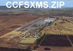
Revised 1/7/10 for upload to Avsim.COM. CCFSXMSFix is incorporated so not required.
This is an earlier version of CCC Megascenery Earth scenery that doesn't require FSGenesis Mesh Terrain. See CCFSXMSG.ZIP for the FSGenesis Mesh version.
This scenery covers the California coastal region from N36���°10' (Coalinga) to N34���°25' (Santa Barbara) and from the coast East to W119���°40'. It is a version of my previous California Central Coast scenery redesigned and expanded to work with MegaScenery Earth from PC Aviator Inc. Many airstrips in the area covered by this scenery have been added or enhanced for a total of 27 airports/airstrips in the area. Several areas of interest such as the Santa Barbara marina, Morro Bay, etc. are also included for a total of 41 points of interest. All airports/airstrips and related structures have been adjusted and realigned to conform to actual positions and dimensions as indicated by the MegaScenery satellite textures. In addition, there are 6 invisible water runways for use by AI floatplane traffic. MegaScenery California-13, -14 and -15 are required for this scenery to make sense. I also used California-12, -28 and -29 when constructing the scenery but they could be considered optional.
| Filename: | California_Central_Coast_Scenery_for_FSX_with_Mega.zip |
| License: | Freeware |
| Added: | 7th January 2010, 21:28:45 |
| Downloads: | 1,560 |
| Author: | Al Wheeler |
| Size: | 8.12 MB |
| Category: Prepar3D V1-4 - Scenery | |
| Progetto Maldive |
|
File Description:
The Atolls of the Maldives are numerous and some atolls are also uninhabited. The most famous atolls are: The Male Atoll and Baros island N4.18.26 E73.20.91 with the VRMM airport, the Gan atoll N0.41.36 E73.9.27 with the VRMG airport, Hanimardhoo Atoll N6.44.56 E73.10.06 with the VRMH airport, the Kaadedhahoo atoll N0.29.21 E72.59.41 with the VRMT airport and the Kadhdhoo N1.51.30 E73.31.15 with the VRMK airport. The aforementioned airports have been improved and the most important resorts have been created on the islands of Baros, Gan, Hanimaadhoo, Kaadedhahoo and Kadhdhoo, and small ports have been created with ships and boats with Google Maps report. I remember that all the islands can be easily visited by seaplanes in their respective tiny ports. Good VFR flight.
Within the downloaded package you will find readme files for scenery installation. Good fly VFR. Pasquale Marrulli.
| Filename: | Progetto_Maldive.zip |
| License: | Freeware |
| Added: | 29th January 2018, 18:38:35 |
| Downloads: | 328 |
| Author: | Pasquale Marrulli |
| Size: | 8.56 KB |
| Category: Prepar3D V1-4 - Scenery | |
| Broadford Airfield, Scotland : EGEI |
|
Images related to this file:
File Description:

Isle of Skye (Broadford) Airfield (also known as Ashaig Airstrip or Broadford Aerodrome) is a small airfield on the Isle of Skye, Scotland, with a single runway. It is next to the hamlet of Ashaig, near the village of Broadford. The airport was constructed by the Corps of Royal Engineers and opened in 1972 to serve as a gateway to the Isle of Skye. Loganair operated a scheduled service from the airfield to Glasgow from 1972. However this service was discontinued in 1988. No commercial services have existed since then, and the airfield is usually deserted although the airport is occasionally used by NHS Highland and the Scottish Ambulance Service for transferring patients to hospitals in Inverness or Glasgow. Discussions were started in 2012 regarding the reinstatement of the airfield for commercial use but, as yet, this has not happened.
| Filename: | Broadford_Airfield_Scotland__EGEI.zip |
| License: | Freeware |
| Added: | 3rd November 2019, 18:31:13 |
| Downloads: | 674 |
| Author: | Andy Kewley |
| Size: | 178.5 MB |
| Category: Flight Simulator X - Utilities | |
| Landing Parameters for FSX and P3D |
|
Images related to this file:
File Description:
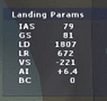
Landing_Params is a Lua script for FSX/P3D that displays landing parameters in a small text window that pops
up after the aircraft has landed and has reached taxi speed. The script should be activated with a key or button (like the gear
down key/button) during the approach to landing. Parameters displayed in the window after touchdown are
Indicated Airspeed (IAS, Kts), Ground Speed (GS, Kts), Landing Distance (LD, ft), Landing Roll (LR, ft), Vertical
Speed (VS, ft/min), Attitude Indicator pitch at touchdown (AI), and Bounce Count (BC). Data collection begins
when the a/c passes through a radar altimeter determined threshold altitude window between 45 and 55 ft
(i.e., the nominal 50ft threshold height). In addition, more detailed landing parameter information may be
logged. A registered copy of FSUIPC is required to execute the Lua script.
| Filename: | Landing_Parameters_for_FSX_and_P3D.zip |
| License: | Freeware |
| Added: | 18th February 2018, 04:09:32 |
| Downloads: | 568 |
| Author: | Al Klayton |
| Size: | 164.08 KB |


© 2001-2026 AVSIM Online
All Rights Reserved
Privacy Policy |