
Where Flight Simulation Enthusiasts Gather from Around the World!
AVSIM Library - Search Results

| Category: Flight Simulator X - Panels | |
| F-111 Aardvark HUD - Navigation/Situation awareness cockpit with RADAR |

|
Images related to this file:
File Description:
FSX Alphasim F-111 Aardvark HUD. Navigation/Situation awareness cockpit.
REVISION 4. UPGRADE. COMPLETE PACKAGE. Adds upgraded dual role air-to-air ground mapping RADAR with target lock up and script on radar and HUD to enable precise intercepts in all weather day or night and new Sound. Massive amount of digital data.
Must have ALPHASIM F-111 Aardvark to build up this complete and separate F-111. Exceptional capability cockpit Comprising:
-Pilot, WSO and virtual panels;
-3 MFD with 19 selectable pages of data;
-NEW RADAR and 3 GPS type moving maps;
-16 Nearest airports page with full Citynames and ICAO entry capable displays in HUD;
-Clipboard, autopilot;
-Autothrottle and TFR;
-Enhanced HUD is selectable in all views including 10 camera views;
-All data clearly readable size;
-Aircraft carrier capable;
-Effects: bombs, missiles, flares, dump and burn, exhaust trail;
-Detailed REVISED 48 pge Flight Manual plus docs folder.
Configuration ensures crisp and extremely precise controlled flight even down to
10 ft AGL. This panel will set a new benchmark of the amount and type of
data provided and its presentation. Possibly the best pilots' aircraft ever.
Simple Panel replacement if previous version already installed.
By Karol Chlebowski.
| Filename: | F111_Aardvark_HUD__NavigationSituation_awareness_c.zip |
| License: | Check within download |
| Added: | 31st December 2009, 03:09:04 |
| Downloads: | 1,072 |
| Author: | Karol Chlebowski |
| Size: | 35.61 MB |
| Category: Flight Simulator 2004 - Original Aircraft | |
| Lockheed L-749 Constellation Base Pack |
|
Images related to this file:
File Description:
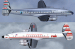
Dimensionally identical to the first-generation Constellation (L-049), the
post-war 749 had more powerful engines, additional fuel tanks, strengthened
landing gear, and much improved performance. Equally good for shuttle hops
and long-range flights, L-749 Connies entered service with major 1950s
carriers such as Eastern, TWA, B.O.A.C., Air France, KLM, Quantas, and many
others. Another customer was the Air Force, which placed an order for ten
aircraft (designated C-121A) in 1948.
Included in this sim package are seven
models and five textures, covering variants with and without "Speedpak"
cargo pannier, weather radar, and "jetstack" exhausts. KLM texture by Jaap
de Baare (representing "Flevoland", the last 749 in flying condition today).
TWA texture N6003C "Star of America" by Hans Herrmann. EAL, Air France, and
MATS textures by Manfred Jahn (including "8609", a frequent visitor to
airshows all over the world until 2005). Panel textures and additional
gauges by Diego S. Barreto, model and VC by Manfred Jahn, panels, gauges,
and animations by Hansjoerg Naegele, flight dynamics by Luis Pallas,
wingview angles, lights, and exhaust effects by Bill Tyne and Roland Berger,
checklist and documentation by Volker Boehme, flight test and handling
research by Stefan Werner. The 749 project has been hosted by Tom Gibson's
Calclassic forum at http://calclassic.proboards55.com.
| Filename: | Lockheed_L749_Constellation_Base_Pack.zip |
| License: | Freeware |
| Added: | 5th December 2009, 04:07:37 |
| Downloads: | 23,653 |
| Author: | Manfred Jahn and 749 Team |
| Size: | 36.17 MB |
| Category: Flight Simulator X - AFCAD Files | |
| Halka Nurseries Airport (9NJ6), NJ |
|
File Description:
Located 02 miles W of Fairton, New Jersey on 150 acres of land, Halka Nurseries Airport is a private turf strip 2400' in length. The airspace has been analyzed and deemed suitable for aircraft up to a light twin. Take caution on the Runway 18 approach as power lines are strung up along the street opposite the runway. There is no hard surfaced runway so have your terrain mesh set as high as possible to experience bumpy terrain. There is no windsock, so be sure to know your weather before arriving or departing - the winds in this area are predominantly out of the west and this runway is north/south. Trees and bushes are close to some areas of the runway and can pose a danger in high crosswinds. There are no services for transient aircraft.
Scenery constructed with use of satellite images/streetview/aerial photos - the author has not been there in person.
This scenery is meant to be used in conjunction with MegaScenery Earth New Jersey/Delaware 005. It is not required, but apron use is minimized to allow satellite scenery to show through as much as possible, and objects are placed based on the MSE textures - lack of it may make scenery look out of place.
| Filename: | Halka_Nurseries_Airport_9NJ6_NJ.zip |
| License: | Freeware |
| Added: | 6th April 2011, 03:27:56 |
| Downloads: | 207 |
| Author: | Drew Sikora |
| Size: | 829.12 KB |
| Category: Flight Simulator X - AFCAD Files | |
| Paramount Air Airport JY04 , NJ |
|
File Description:
Located 01 miles N of Green Creek, New Jersey on 20 acres of land, Paramount Air Airport is a private turf strip 2000' in length, although about 300' of it at the end of Runway 32 isn't in the best shape. The runway is 100' wide but closely hedged in by trees along both sides for the length of the runway. A hangar is past the end of Runway 14 but no services are offered for transient aircraft. Still, you can choose to start parked at the hangar if you wish. There is no hard surfaced runway so having your terrain mesh set as high as possible is recommended. No windsock is present, so know your weather (KWWD is very close by) and the airport is unlit so daytime VFR operations only are recommended.
Scenery constructed with use of satellite images/streetview/aerial photos - the author has not been there in person.
This scenery is meant to be used in conjunction with MegaScenery Earth New Jersey/Delaware 005. It is not required, but apron use is minimized to allow satellite scenery to show through as much as possible, and objects are placed based on the MSE textures - lack of it may make scenery look out of place.
| Filename: | Paramount_Air_Airport__JY04__NJ.zip |
| License: | Freeware |
| Added: | 20th April 2011, 16:42:48 |
| Downloads: | 179 |
| Author: | Drew Sikora |
| Size: | 418.37 KB |
| Category: Flight Simulator 2004 - Scenery | |
| Clyde River CYCY & Cape Christian in Nunavut Canada |
|
Images related to this file:
File Description:
Clyde River is a village on the northeast coast of Baffin Island, 250 miles above the Arctic Circle and around 150 miles north of Cape Hooper. It is on the shore of Patricia Bay at the entrance to Cylde Inlet, a fjord which stretches over 60 miles inland. The population is around 880 folks, and it was named by the explorer John Ross in 1818. The airfield is just east of the village and the lighted runway is 3,501' of 100' wide gravel at 87' ASL, aligned 018 True 198 True; "True" as opposed to magnetic in the Northern Domestic Airspace. There are two aprons, one with the new terminal building and one with the old terminal and the garage. Five miles northeast of Clyde River is Cape Christian, where there is a gravel runway around 3,000' long and adjacent to the beach, built to serve what was started as a weather station and later became a LORAN navigation system station. The station is still there, though it was closed some time ago and is now the subject of decontamination work. The runway is usable, though only for light planes as it is a bit rough. First Air and Canadian North are the AI planes visting Clyde River.
| Filename: | Clyde_River_CYCY__Cape_Christian_in_Nunavut_Canada.zip |
| License: | Freeware |
| Added: | 14th July 2011, 20:26:14 |
| Downloads: | 456 |
| Author: | Roger Wensley |
| Size: | 3.33 MB |
| Category: Flight Simulator 2004 - Scenery | |
| Rae Lakes CYRA at Gameti in the NW Territories Canada, corrected |
|
Images related to this file:
File Description:
This is a corrected version that rectifies the airfield elevation, which I forgot to include in the first post; 120 downloads and nobody tells me till now? The remainder of this is as first written, apart from the installation instructions: Gameti is a village in the Northwest Territories, around 65 miles north of Whati, which was recently posted. Until 2005 the village, which has a population of around 280, was known as Rae Lakes and the airfield is now renamed Gameti/Rae Lakes as shown in the 2010 version of the Nav Canada Flight Supplement, my standard reference year. Permanent settlement was established there in 1965 There is no all-weather road access and the village is reliant upon the airfield for supplies, along with an ice road in the winter months. The airfield is a mile or so east of the village, with a lit gravel runway of just over 3,000 feet aligned 14-32 and with PAPI at both ends. The airfield is served by Air Tindi from Yellowknife on an almost daily basis, included in the AI here along with some GA and a Friday delivery by a Buffalo DC3 that uses all of the runway. The runway has lake water at each end, ready for the unwary.
| Filename: | Rae_Lakes_CYRA_at_Gameti_in_the_NW_Territories_Can.zip |
| License: | Freeware, limited distribution |
| Added: | 30th November 2020, 18:04:00 |
| Downloads: | 136 |
| Author: | Roger Wensley |
| Size: | 3.9 MB |
| Category: Prepar3D V1-4 - Missions | |
| C-27 Spartan JTAX Maneuver Caribbean Sea |
|
Images related to this file:
File Description:

This package is a ficitional campaign with 28 single mission days. The tasks are typical for tactical air transport operations, containing low flying, day- and night ops, airdrops, medevacs... The mission package is designed for the IRIS Battlefield Airlifter (Payware) but may be used also with other aircraft. Here is the basic story: The Royal Airforce sent their new Alenia / Leonardo C-27 Spartan to the Caribbean Sea for the current Joint Transatlantic Exercise (JTAX). You are one of the selected pilots for this campaign. There are two atlantic crossing flights included but mostly short missions within theatre of operation. All locations used are default scenery. Eventually You have to adjust starting positions or waypoints if You are using special scenery within caribbean area. Content: Saved Flights for each mission (P3DV4 standard flights using IRIS Battlefield Airlifter with default liveries) Weather files for each mission (P3DV4 standard flights) P3D Flight plans (Default flight planner) Mission explanation and daily orders (PDF files) Addidional NAV-Logs for the atlantic flights (PDF files). Read the mission documents, load the flights at P3D and fly them as often as You want. The Campaigns use the following airports and locations: EGVN, GVSV, TKPK, MKJP, MKNG, MWCL, MWCB, MWCR, MUGM, MYIG, CYQX, Jamaica area, Cayman islands and Inagua / West Indies.
| Filename: | C27_Spartan_JTAX_Maneuver_Caribbean_Sea.zip |
| License: | Freeware |
| Added: | 1st March 2021, 00:58:13 |
| Downloads: | 121 |
| Author: | Alex Jorda |
| Size: | 21.23 MB |
| Category: Flight Simulator X - Utilities | |
| FSRemote |
|
File Description:
It does what the title says FSRemote controls FSX remotely through FSUIPC.
Just take a look at the (word) document that is contained in the zip file and look at some screen shots.
It can view and control the following items in FSX through FSUIPC:
1. Environment - view Date Time and Position
2. Date Time - view and set Date and Time in FSX
3. Aircraft - view and set various aircraft items like Door, Lights, Push back and De-Ice
4. Attitude - view attitude and speed in feet, meter, knots, mp/h and km/h
5. Auto Pilot - view and set various Auto Pilot items
6. Radio - view and set almost all the radio items like in the radio stack
7. Engines - auto stop and start engines, not much jet
8. Message - view and send messages to FSX
9. Weather - not implemented jet
10. FPS - view chart and check the Frames per Second in FSX
11. About box with various version information.
What do you need run use FSRemote
1. .NET 2.0 installed on the comupter where you want to run FSRemote
2. FSUIPC4 on the computer where you run FSX
3. WideClient (FSUIPC remote) if you want to run FSRemote on a remote computer
The zip file includes:
1. .NET 2.0 FSRemote executable
2. Configuration file for FSRemote
3. Document file in MSWord
Hope you like it.
| Filename: | FSRemote.zip |
| License: | Freeware |
| Added: | 4th September 2007, 11:52:19 |
| Downloads: | 1,481 |
| Author: | Hans Elzer |
| Size: | 311.67 KB |
| Category: Flight Simulator X - Missions | |
| SAR...Bimbo, Zula, Dobo |
|
File Description:
Russian Circus " Flying Sagitarius" (ïîëåò Sagitarious ) is visiting
Georgia and its mountain communities. Due to the cold weather, not expected by Yokoliv Burulov,
owner and trapeze swinger of the circus, three of his "stars" had to be taken by truck to a hospital since
their bowels have suffered " Dirruscus-Megra" a common cold water desease in the mountains. The three
ill "stars" are the Elephant "Bimbo"--"Zula" the laughfing Zebra and "Dobo" the great Dansing Russian Brown Bear...
Together these animals are worth around 75,000 Rubles in the Circus Markets.----Now Yokoliv has received
a call that the truck had an accident on the road and the three characters have run into the mountains. Not
wasting time he has asked the nearby Air Force Base for help. General Gustrgy Bonklovsky commander of the base and circus lover, has agreed to provide him with a SAR helicopter that will search the area and find at all cost the Animals....You are called to be the pilot for the mission at hand. Its cold, muggy and for the last three days fog has been lingering all over the mountains.---"this is the life pilot" says General Bonklovsky , as he hands you the search area map with a sardonic smile. You smell the presence of resently drunk Vodka and leave the hut toward the spinning Chopper.---Download MI-8 Helicopter for Mission
| Filename: | SARBimbo_Zula_Dobo.zip |
| License: | Freeware, limited distribution |
| Added: | 28th April 2008, 04:29:52 |
| Downloads: | 1,166 |
| Author: | Gera Godoy Canova |
| Size: | 5.96 MB |
| Category: Flight Simulator 2004 - Miscellaneous Files | |
| Active ILS - LEBL (El Prat - Barcelona Airport) |
|
File Description:
As most know initiating the ILS at certain airports for AI Traffic or the User Aircraft is not a function at this time when using AFCAD2. If you add a new ILS runway to an airport such as LEBL (El Prat/Barcelona 7R/25L) only the user aircraft can use this runway (without ATC commands) when visibility falls below 3 miles. ATC will no longer use this runway for AI Traffic because FS9 sees it as a visual runway. This will cause ATC to vector all your AI Traffic back to runway 7/25 old numbers, 7L/25R new numbers which is also a Terminal departure runway. This ILS bgl file adds all NAVAIDS for making 7R/25L a Precision Instrument Runway by adding all the radar fixes for both the ILS approach portion and the missed approach procedures, altitudes and intersections as per current published plates. All AI Aircraft/User Planes will now continue to use the new 7R/25L runway when Airport weather conditions are less than 3 miles. ATC will also use the right naming/numbers of the runways. The DME/VOR approaches have also been written using the new BCN/PRA VOR's for runways 7L/25R and 02. Many different default FS9 scenery GUID's added including Taxiway Signs *** FS2004 Default Scenery AFCAD2 included with the new 7R/25L runway ***
| Filename: | Active_ILS__LEBL_El_Prat__Barcelona_Airport.zip |
| License: | Freeware, limited distribution |
| Added: | 30th December 2004, 17:53:42 |
| Downloads: | 2,842 |
| Author: | Jim Vile |
| Size: | 31.51 KB |


© 2001-2026 AVSIM Online
All Rights Reserved
Privacy Policy |