
Where Flight Simulation Enthusiasts Gather from Around the World!
AVSIM Library - Search Results

| Category: Flight Simulator 2004 - Scenery | |
| John McAllister & Sons, Fisheries, British Columbia, Canada |

|
File Description:
John McAllister's fisheries is situated some 50 nm North West of Vancouver Int'l Airport. This 'fictitious' scenery is part of my BC Short Hops series. Complete facilities for Seaplanes and a steel slab runway for wheel landings.
Lots of candies on this site.
| Filename: | John_McAllister__Sons_Fisheries__British_Columbia_.zip |
| License: | Freeware |
| Added: | 15th November 2004, 21:20:31 |
| Downloads: | 1,677 |
| Author: | Leon Louis |
| Size: | 2.81 MB |
| Category: Flight Simulator 2004 - Scenery | |
| Terrace CYXT in British Columbia, Canada - REVISED |
|
Images related to this file:
File Description:
This version includes the correct Piper Cub texture, unreported by all but one downloader (why?).
Terrace is fifteen miles east and inland from Prince Rupert, which is 500 miles north of Vancouver up the BC coast. It is at the point in the mountains where two fjords meet, one coming from Prince Rupert and the other from Kitimat. The airport is a couple of miles south of the town and on the south side of the Skeene River. There are two runways, and the main one is a recently-extended 7,500 feet long and lighted 33/15. The second is 5,373 feet of unlit 03/21. The apron has been enlarged to be able to accommodate a Boeing 737 so I have parked an Air Canada jet there, but the pics show the planes that do fly to Terrace, and these are Air Canada and Hawk Air Dash 8-300's. The original aircraft and the textures are down-loadable and and can be used for AI.
| Filename: | Terrace_CYXT_in_British_Columbia_Canada__REVISED.zip |
| License: | Freeware, limited distribution |
| Added: | 21st February 2010, 16:25:38 |
| Downloads: | 1,112 |
| Author: | Roger Wensley |
| Size: | 3.39 MB |
| Category: Flight Simulator 2004 - Scenery | |
| Port McNeill CAT5 in British Columbia, Canada |
|
Images related to this file:
File Description:
Port McNeill is at the northern end of Vancouver Island, on the coast and around 20 miles east of Port Hardy. The town population is just over 2,000 and the main industry is logging, followed by sand and gravel quarrying and exporting for the construction industry. Tourism rates third.
The airport, a mile or so east of the town, provides a swift connection for nearby islands and the surrounding area to the rest of the west coast, and serves as the HQ main base for West Coast Helicopters. Their newly built large hangar and office accommodation is next to their older hangar to one side of the central public parking area, opposite the club house cum terminal and hangars. There are two runways: 06-24 which is asphalt, 2,400 feet long, and lit; and 11-29 of gravel, 3,650 feet long and also lit. There is some taxiway lighting, but not, for instance, for the connection between runways, which is in real life a ramp up to the gravel runway which is 15 feet higher. There are no regularly scheduled flights and traffic consists mainly of the West Coast helicopters, plus GA and irregular charters, the latter being mostly from Port Hardy.
| Filename: | Port_McNeill_CAT5_in_British_Columbia_Canada.zip |
| License: | Freeware, limited distribution |
| Added: | 18th November 2018, 05:49:13 |
| Downloads: | 138 |
| Author: | Roger Wensley |
| Size: | 13.29 MB |
| Category: Flight Simulator 2004 - Scenery | |
| CYPR - Prince Rupert - British Columbia, Canada 2012 |
|
Images related to this file:
File Description:
Another nice little B.C. airport. Remember, all our sceneries are raised cage free and are gluten free.
| Filename: | CYPR__Prince_Rupert__British_Columbia_Canada__2012.zip |
| License: | Freeware |
| Added: | 2nd March 2013, 10:53:51 |
| Downloads: | 1,064 |
| Author: | Sidney Schwartz |
| Size: | 1.69 MB |
| Category: Flight Simulator 2004 - Scenery | |
| Dawson Creek CYDQ in British Columbia, Canada |
|
Images related to this file:
File Description:
Dawson Creek is at 2,148 feet asl just east of the Rocky Mountains, less than 10 miles west of the BC/Alberta border. The Peace River, 25 miles north of Dawson Creek, links the two sides of the Rockies, winding through peaks that reach up almost to 8,000 feet. The population grew when the Northern Alberta Railway was extended to Dawsons Creek in 1932, and grew even more more when the Alaska Highway was built in 1942 and Dawsons Creek was where it started from. The airport is just to the east of the town. The runway is 5,000 feet of wide asphalt (150 feet) aligned 06/24, lit, and with PAPI and approach lights. There is a water runway to the north of the main runway with the same alignment, separately designated as Dawson Creek CBD3. The two operate as one; traffic for both use the mandatory frequency of 122.2 and talk to one controller in one control tower. However, in FS9 the ATC for two separately designated airfields operates as if they are nowhere near each other and near misses are the result. I have put them both in un-manned tower mode so you will announce your position and intentions and select your own parking spots etc. There is in reality a lack of apron markings but I have marked the positions of both gates. The apron is not large so there is only one other apron parking spot (see the traffic cone) and most parking is either next to one of the hangars or on the grass. The aprons vary from asphalt, to concrete, onwards to gravel, and then further onwards to some gravel amid the bare dirt; I have replicated this variation as far as FS9 permits. The buildings are bespoke from photos. The AI includes Central Mountain Air with two daily scheduled flights and Northern Cariboo as one of the airlines that occasionally runs charter flights in CYDQ. There are also private GA flights, and float plane flights into and out of CBD3.
| Filename: | Dawson_Creek_CYDQ_in_British_Columbia_Canada.zip |
| License: | Freeware, limited distribution |
| Added: | 22nd November 2013, 23:31:40 |
| Downloads: | 654 |
| Author: | Roger Wensley |
| Size: | 16.65 MB |
| Category: Flight Simulator 2004 - Scenery | |
| Fort Nelson CYYE in British Columbia, Canada |
|
Images related to this file:
File Description:
Fort Nelson is close to the Peace River in the northeast corner of British Columbia, around 70 miles from the northern border, 90 from the eastern border, and 80 miles east of the Rockies. The wartime construction of the Alaska Highway actually started from Fort Nelson, as there was already a road from Fort St John (which is close to Dawson Creek) north to Fort Nelson. The airfield was part of this construction effort and after the wartime ferrying of planes to Russia it was used by the US Army Air Force and then by the Canadian Air Force. Fort Nelson flourished with the oil and gas exploration of the 1950's and the following years, and this continued to grow until the collapse of the oil price in 2014.
The town of Fort Nelson became the capital of the Northern Rockies Regional District when it was founded in 2009, and as a result the official name of the Fort Nelson airport is the Northern Rockies Regional Airport. The date for this scenery is around 2016, by which time the economic fortunes of the town were in decline. Five times per day flights by Central Mountain Air were starting to be reduced in number to the current (in 2022) one per day and none on Sunday; in the AI included here there are two flights per day. The main resident users of the airport are four helicopter companies, the helicopters presumably used for maintenance trips to whatever parts of the oil and gas fields that are still in use in the surrounding area.
There are two runways, the main one is aligned 03-21, 6,400 feet long and 200 feet wide, with ILS at the southern end and PAPI at the northern. The second runway (a narrower rebuild on a previously existing runway) is aligned 07-25 and 77 feet wide, and is without any lights. These are the alignments as per the original build of FS9 and not as per the approximate 2016 date of the buildings; I had a problem at a very late stage in making this scenery which prevented me from continuing with some final details.
On YouTube there is a series of posts by Angle of Attack showing the preparation and then the flight of an old Cessna 172 from Homer to Oshkosh for the installation of modern instruments. Interesting for me as they visit or fly over airfields I have made (Homer, Merrill, Tok Junction, Burwash, Silver City, Haines Junction, Watson Lake, Fort Nelson, and Grande Prairie) but in the winter so it all looks very different.
| Filename: | Fort_Nelson_CYYE_in_British_Columbia_Canada.zip |
| License: | Freeware, limited distribution |
| Added: | 23rd January 2022, 20:11:18 |
| Downloads: | 188 |
| Author: | Roger Wensley |
| Size: | 28.35 MB |
| Category: Prepar3D V1-4 - Scenery | |
| CYVR - Vancouver Intl Airport - British Columbia, Canada |
|
Images related to this file:
File Description:
This is Ray Smith's file (fsx_cyvr_rs.zip) created for FSX. Ray has given me permission to convert his file for Prepar3Dv2,v3. This airport update has two optional files, one version with the Crosswind runway activated where all 3 runways will be used for takeoff/landing and one version as the default runway operation: Assigned parking as per their website with extra parking including a gate for the A380, the crosswind runway corrected to 13/31 and the approaches corrected for it, runway 08C/26C decommissioned and is now taxiway A, the Canada Post Pacific Processing centre and Ferguson Rd also included, taxiways and taxi signs updated to the latest charts, start locations added to two of the helipads, extra fuel trucks, support vehicle roads rebuilt and many other scenery improvements included, airport views are from the roof of the control tower (when in tower view) please view the readme before installation.
| Filename: | CYVR__Vancouver_Intl_Airport__British_Columbia_Can.zip |
| License: | Freeware |
| Added: | 7th March 2016, 21:45:25 |
| Downloads: | 14,759 |
| Author: | Robert Catherall |
| Size: | 2.46 MB |
| Category: Flight Simulator X - Aircraft Repaints, Textures and Modifications | |
| Columbia Airlines "Airport '75" Boeing 747-400 |
|
Images related to this file:
File Description:
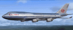
Fictional repaint for FSX default 747 model, from movie "Airport '75".
File ReadMe included.
| Filename: | Columbia_Airlines_Airport_75_Boeing_747400.zip |
| License: | Freeware |
| Added: | 1st February 2016, 10:08:22 |
| Downloads: | 220 |
| Author: | Luca "MiB" Paoloni |
| Size: | 6.21 MB |
| Category: Flight Simulator 2004 - Scenery | |
| AI Helicopters for Penticton, British Columbia, Canada. |
|
Images related to this file:
File Description:

AI Helicopters for Penticton, British Columbia, Canada. This package is designed to compliment the exceptionaly fine enhancement of the airport (CYYF) by John Stinstrom. Featured are three repaints by John Burford of the Sikorsky S-76 AI Helicopter in Canadian Helicopter's colors. The AI Helicopter model by Chris "Elvis" Jones is not included but download details for it and other suggested enhancements are included in the documentation. The project uses the "invisible" airport and "forward departure" (no push-backs) techniques. Please unzip to a temporary folder and follow the very easy installation instructions. Compiled for your flying enjoyment by David "Opa" Marshall. ---
NOTE: This single package replaces three related files destroyed in the May hack upon Avsim.
| Filename: | AI_Helicopters_for_Penticton_British_Columbia_Cana.zip |
| License: | Freeware |
| Added: | 28th January 2010, 14:57:01 |
| Downloads: | 4,900 |
| Author: | David "Opa" Marshall & John Burford |
| Size: | 837.98 KB |
| Category: Prepar3D V1-4 - Scenery | |
| CYXS - Prince George Airport - British Columbia, Canada |
|
File Description:
CYXS Prince George - British Columbia, Canada by Robert Catherall
This airport update is made only for Prepar3Dv2 and Prepar3Dv3. Runways have been repositioned and runway 15/33 extended from 7400 ft to 11450 ft. ILS repositioned to runway 15. Roads, parking areas and new buildings added. Aprons readjusted. Rotating beacon added to the top of the control visible at night. Parking for AI aircraft and refueling truck added.
| Filename: | CYXS__Prince_George_Airport__British_Columbia_Cana.zip |
| License: | Freeware |
| Added: | 13th January 2016, 22:18:45 |
| Downloads: | 366 |
| Author: | Robert Catherall |
| Size: | 2.81 MB |


© 2001-2026 AVSIM Online
All Rights Reserved
Privacy Policy |