
Where Flight Simulation Enthusiasts Gather from Around the World!
AVSIM Library - Search Results

| Category: Flight Simulator 2004 - Scenery | |
| USS Langley relocation to British Columbia -- 2 locations |

|
File Description:
These files relocate the USS Langley of the MAAM Avenger package into the waters of British Columbia, Canada.
CVL48 is located South of Victoria Harbour (CYWH) and North of Port Angeles (KNOW), Washington in the Strait of Juan de Fuca.
CVL49 is located NW of Vancouver (CYVR) in the Strait of Georgia.
| Filename: | USS_Langley_relocation_to_British_Columbia__2_loca.zip |
| License: | Freeware, limited distribution |
| Added: | 10th August 2008, 09:16:39 |
| Downloads: | 1,200 |
| Author: | Brent Hricziscse and Bill Dick |
| Size: | 1.82 MB |
| Category: Flight Simulator 2004 - Scenery | |
| Byron Bay CWBB plus Edinburgh Island CWEI in Nunavut, Canada |
|
Images related to this file:
File Description:
Byron Bay was a DEW line station on the south coast of Victoria Island, 105 miles east of Lady Franklin Point. It closed in 1993. The buildings are still there, slowly accumulating the patina so admired by collectors on Antiques Roadshow. The runway is just over 4,500 feet and aligned 58T-238T. At the mid point between Lady Franklin Point and Byron Bay there is a North Warning Site on the highpoint of Edinburgh Island, just south of the closed Ross Point station on the "mainland" Victoria Island. The runway is just over 1,400 feet and is also up on the top of the island. There is a steep road down 600 feet to the coast for the annual fuel resupply and maintenance.
| Filename: | Byron_Bay_CWBB_plus_Edinburgh_Island_CWEI_in_Nunav.zip |
| License: | Freeware, limited distribution |
| Added: | 11th November 2012, 21:07:05 |
| Downloads: | 246 |
| Author: | Roger Wensley |
| Size: | 2 MB |
| Category: Flight Simulator X - Scenery | |
| Lighthouses on either side of The English Channel Between Dover and Calais |
|
Images related to this file:
File Description:
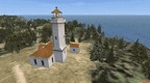
That freeware FSX scenery is adding lighthouses either side of the English Channel Between Dover and Calais. Such lighthouses are the one of the Gris-Nez Cape, France, the one of St Margaret (UK) and too a jetty lightouse for the harbor of Dover (idem). Comes with a French readme too.
| Filename: | Lighthouses_on_either_side_of_The_English_Channel_.zip |
| License: | Freeware |
| Added: | 16th July 2014, 16:35:48 |
| Downloads: | 545 |
| Author: | Gerard Guichard |
| Size: | 178.64 KB |
| Category: Flight Simulator X - Scenery | |
| YMMB Moorabbin Victoria and Albert Park F1 Circuit, AUSTRALIA |
|
Images related to this file:
File Description:
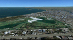
Photorealistic scenery for FSX (should work on P3D V 1-4).
Overlapping edges from photo into default scenery.
Enhanced airport close to real with custom buildings and some static objects.
Day and Night textures.
Some autogen at airport, circuit and surrounding areas.
FTX Global and Vector compatible.
| Filename: | YMMB_Moorabbin_Victoria_and_Albert_Park_F1_Circuit.zip |
| License: | Freeware |
| Added: | 24th June 2021, 23:59:22 |
| Downloads: | 154 |
| Author: | Ignacio Del Muro |
| Size: | 41.41 MB |
| Category: Flight Simulator 2004 - Scenery | |
| The Victoria Falls of the Zambezi River, Zambia/Zimbabwe |
|
File Description:
One of the main landmarks of Africa, the spectacular Victoria Falls of the Zambezi River are missing in out-of-the-box FS. With a local SRTM LOD9 mesh as a base (included) and the help of satellite imagery, maps, Ground2K4, and GMax, we did our best to model a realistic representation of the falls, the river, and the gorge, complete with custom waterfall and spray effects. The portion of the Zambezi covered in this project extends from E25 to E26.5 (more than 100km), with the falls at its center. Also included is a replacement landclass file for an area of about 20km on either side of the Zambezi River and an optional AI boat (by Lynn and Bill Lyons) cruising on the Zambezi above the falls. Tested with FS2004 only but most scenery enhancements (not the AI boat) should work just as well in FS2002.
| Filename: | The_Victoria_Falls_of_the_Zambezi_River_ZambiaZimb.zip |
| License: | Freeware, limited distribution |
| Added: | 8th May 2004, 02:45:30 |
| Downloads: | 19,139 |
| Author: | Holger Sandmann and Johan van Wyk, Aeroworx |
| Size: | 3.5 MB |
| Category: Flight Simulator 2004 - Scenery | |
| HUEN - Entebbe Intl. Airport, Uganda, Africa |
|
File Description:
Entebbe Airport is the main international airport of Uganda. It is located near the town of Entebbe, on the shores of
Lake Victoria and about 35 km from the capital Kampala.
The airport is designed to match the real one, starting from runway to highway. Vehicles are not included, they are
in separate file (ebb_ground.zip).
| Filename: | HUEN__Entebbe_Intl_Airport_Uganda_Africa.zip |
| License: | Freeware |
| Added: | 14th August 2008, 09:17:01 |
| Downloads: | 4,563 |
| Author: | Nuhaid Abdulkhaleq |
| Size: | 996.18 KB |
| Category: Flight Simulator 2004 - Scenery | |
| Lake Edward elevation modification |
|
Images related to this file:
File Description:
Modified HP and HL files to raise the level of Lake Edward to fit with terrain with 76m mesh.
The water area around Entebbe airport has also been modified.
Victoria-Nile River has been moved south of Chobe Safari Lodge Strip which was in the river before.
Some modified files for airstrips in Uganda.
| Filename: | Lake_Edward_elevation_modification.zip |
| License: | Freeware |
| Added: | 25th October 2022, 14:30:54 |
| Downloads: | 92 |
| Author: | John Tennent |
| Size: | 759.5 KB |
| Category: Flight Simulator 2002 - Scenery | |
| KPHX ILS Fixes |
|
File Description:
BGL scenery file that fixes the ILS's at KPHX Sky Harbor to include the missing ILS for Runway 8 and the backcourse to 25R. Also includes the Runway 29R backcourse at KTUS. Note, the ILS beams don't show up in the FS GPS or MAP view, but they work fine in the sim.
| Filename: | KPHX_ILS_Fixes.zip |
| License: | Freeware |
| Added: | 11th September 2002, 05:26:14 |
| Downloads: | 611 |
| Author: | Ryan Maziarz |
| Size: | 5.72 KB |
| Category: Navigation and ATC - Navigation | |
| Dutch Harbor Sectional & Insets Chart Chunks for Aerosoft's FSMap |
|
File Description:
Sectional chart chunks made from the August 2009 Sectional charts at the original scale, formatted in the WGS84 lat/long geographic coordinate system for the FSMap, moving map application for flight simulation use. The chart chunks are the full sectional divided by 2 tiles (east/west) and converted to baseline 8bit tiffs with packbits compression applied. The images average 6,000x6,000 pixels at about 25mb each, also included is the FSMap fsm Calibration file for importing. No further calibration is needed, just import, save, and enjoy.
| Filename: | Dutch_Harbor_Sectional__Insets_Chart_Chunks_for_Ae.zip |
| License: | Freeware |
| Added: | 26th March 2010, 00:23:56 |
| Downloads: | 436 |
| Author: | David Myers |
| Size: | 12.84 MB |
| Category: Flight Simulator 2004 - Scenery | |
| Phoenix Sky Harbor KPHX Concourse D / -Version 2-1- |
|
File Description:
This file adds the new Terminal D for Southwest Airlines at KPHX. This version 2-1 is a software update from version 2. Missing libraries are now included, and you do not need any other files for this scenery to work.
| Filename: | Phoenix_Sky_Harbor_KPHX_Concourse_D__Version_21.zip |
| License: | Freeware |
| Added: | 17th June 2006, 22:41:14 |
| Downloads: | 5,652 |
| Author: | William Morgan / FRF Studio |
| Size: | 1.13 MB |
© 2001-2026 AVSIM Online
All Rights Reserved
Privacy Policy |