
Where Flight Simulation Enthusiasts Gather from Around the World!
AVSIM Library - Search Results

| Category: Flight Simulator X - Scenery | |
| Winter Haven, FL Gilbert Airport (KGIF) and Jack Browns Seaplane School (F57) |

|
Images related to this file:
File Description:
Winter Haven's Gilbert Airport is somewhat unique in that it adjoins Jack Browns Seaplane School on Lake Jessie. The airport serves as a fly-in location for the nearby Lakeland Sun N' Fun airshow where camping is allowed under aircraft wings on the apron.
Scenery in this package is based on Virtual Earth (Bing) and Google Earth imagery. Gilbert Airport includes a new GA terminal and apron and is connected with a taxiway to Jack Browns Seaplane School. Ramps from the water to the apron at Jack Browns are also included. Landclass changes, roads, rework of taxiways and aprons, placement of library objects and a library of new airport buildings are included.
| Filename: | Winter_Haven_FL_Gilbert_Airport_KGIF_and_Jack_Brow.zip |
| License: | Freeware |
| Added: | 9th May 2010, 08:29:56 |
| Downloads: | 907 |
| Author: | Art Poole |
| Size: | 759.09 KB |
| Category: Flight Simulator 2002 - Adventures | |
| Emma Field Sightseeing Tour |
|
File Description:
Fly a VFR-tour in the area east of Seattle, Washington. You will need some skills of bush-flying.
Included in this package are a detailed tour-description (in both English and Dutch) and maps, one per stage.
You will leave from Emma Field and visit the following airfields: Ranger Creek, Easton State, Bandera State, Skykomish State, Lake Wenatchee State, Ross Private Strip, Lost River Resort, Darrington Muni and Diamond Point, before you return to Emma Field.
This tour is based on the products Emma Field, GeoRender 1, GeoRender 3, GeoRender 4, FS Scenery Enhancer and FS SoundScape (all Lago), but can also be flown without (one of) these.
Also included are extra FSSE sceneries and FSSS sound collections.
| Filename: | Emma_Field_Sightseeing_Tour.zip |
| License: | Freeware |
| Added: | 29th June 2003, 15:42:26 |
| Downloads: | 1,463 |
| Author: | Jaap van Hees |
| Size: | 2.67 MB |
| Category: Flight Simulator 2004 - Scenery | |
| Ohio Islands - 3W9 Bass Isle |
|
File Description:
Microsoft Flight Simulator 2004 Scenery - Ohio Islands 3W9
Middle Bass Island - East Point, a general aviation airfield in northern Ohio located in Lake Michigan. Extensively reworked. Features FSDSv2 custom-built hangers and objects in high detail, VTP2 coded ground textures and a detailed airport with full seasonal changes and Autogen support. Includes an amphibious landing area and detailed, animated dock that rises and falls with the tidal swells. Custom lighting throughout. Opening/closing hangar doors. Includes full documentation and map. All required files and textures included. Optimized for FS2004. Created specifically to allow users to adjust frame rates through the use of the Scenery Density/Autogen sliders for increasing levels of detail and realism.
| Filename: | Ohio_Islands__3W9_Bass_Isle.zip |
| License: | Freeware |
| Added: | 12th September 2003, 00:34:28 |
| Downloads: | 2,518 |
| Author: | Mark Smith |
| Size: | 4.37 MB |
| Category: Flight Simulator 2004 - AI Aircraft | |
| US General Aviation AI Pack 5 v2 |
|
Images related to this file:
File Description:

AI for FS2004 in the US south-eastern area, using single-engined Cessna models which are part of the Cessna singles payware package, by Henry Tomkiewicz, available from www.htaimodels.com. These paints are of aircraft residing, at last information, in the states east of the Mississippi as far up as Virginia. The included flightplans have them crossing those states regularly, as well as visiting other states and a few offshore localities. Flightplans and some AFCADs enclosed. Also enclosed - Montauk Airport (KMTP) by John B. Loney Jr, with permission, and basic sceneries for Lake Norman (14A) and Indiantown (X58) which will require a small number of common object libraries. NB - includes AFCAD for MYB9 omitted from original upload.
| Filename: | US_General_Aviation_AI_Pack_5_v2.zip |
| License: | Freeware, limited distribution |
| Added: | 13th March 2015, 01:46:19 |
| Downloads: | 832 |
| Author: | John Burford, John B. Loney Jr |
| Size: | 15.23 MB |
| Category: Flight Simulator 2004 - Scenery | |
| Grand Staircase Escalante National Monument/East, Escalante (1L7), Utah, Photo-Scenery (FS9 & FSX) |
|
Images related to this file:
File Description:
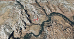
This scenery contains the eastern part of the Grand Staircase Escalante National Monument. It extends from the town of Escalante down south where it connects with the Page/Lake Powell scenery. Contains the upper part of wonderful Escalante Canyon. To explore the scenery depart from Escalante Airport (1L7). Thanks to Joop Mak for providing a custom AFCAD that corrects the airport layout so that it matches with the photo-textures! High resolution versions of this scenery for FS9 and FSX (much sharper, but larger and multiple downloads) are available at www.blueskyscenery.com/CNY_South2West3.html . The screenies are taken from the high-res versions, so expect this version to be slightly more blurry. YourDonation@Work: Dedicated to Jay, Donald and Franz
| Filename: | Grand_Staircase_Escalante_National_MonumentEast_Es.zip |
| License: | Freeware, limited distribution |
| Added: | 4th March 2010, 22:44:30 |
| Downloads: | 1,486 |
| Author: | Gottfried Razek - blueskyscenery.com |
| Size: | 96.2 MB |
| Category: Flight Simulator 2004 - Scenery | |
| Canyonlands National Park, The Maze-South, Utah, Photo-Scenery (FSX too) |
|
Images related to this file:
File Description:
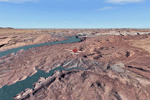
This is a re-upload of a package that was corrupted during the crash of the AVSIM library. This is the fourth package of the Arches/Canyonlands area. It covers the area southwest and including the confluence of the Colorado and Green Rivers. From there you can fly down Cataract Canyon which is famed for its premium whitewater rafting oportunities. Or explore the Maze (the area west of the Green and north of the Colorado River) with it's labyrinth of canyons and colorful sandstone formations. The scenery extends west to Hite (UT03) on Lake Powell. Brings the total Southern Utah coverage to 14.000 sq km in 4.7m/pix quality. YourDonation@Work: Dedicated to Patrick, Hideyuki and Art. Thanks!
| Filename: | Canyonlands_National_Park_The_MazeSouth_Utah_Photo.zip |
| License: | Freeware, limited distribution |
| Added: | 31st December 2009, 22:33:46 |
| Downloads: | 2,083 |
| Author: | Gottfried Razek - blueskyscenery.com |
| Size: | 95.67 MB |
| Category: Flight Simulator 2004 - Scenery | |
| LIPX2006 Verona Villafranca |
|
File Description:
Verona Villafranca aiport is a medium size airport located in north Italy near Verona town, best known for the Romeo&juliet tragedy.This airport has traffic of regular flight and many snow charter to Trentino mountains during thewinter and summer charter to Garda Lake. This scenery reproduces exactly the civil part of the airport using the best techniques to save the frame and improve the detail. The main features are: detailed ground with best texture and right sign and light, Seasonal texture,animation stand, animation object. This scenery is created with the Verona VFR scenery of Francesco Mandelli that you can download from avsim with this name: veronavfrscenery.zip for further information www.isdproject.com or [email protected]
| Filename: | LIPX2006_Verona_Villafranca.zip |
| License: | Freeware, limited distribution |
| Added: | 14th February 2006, 03:12:48 |
| Downloads: | 82,811 |
| Author: | ISDproject |
| Size: | 11.47 MB |
| Category: Flight Simulator 2004 - Scenery | |
| CNZ3 - Chatham-Kent - Ontario, Canada V1 |
|
Images related to this file:
File Description:
This is partly part of the Small Ontario Fields series. The airport ICAO was changed from CNZ3 to CYCK in November 2012; I have left it as it was. The runway too remains as it was a few years ago. Chatham is located 50 miles east of Detroit and 150 miles southwest of Toronto, between Lake St. Clair and Lake Erie, and the airfield is southeast of the town. There is a single asphalt runway 5,000 feet long and 75 feet wide, aligned 05/23 in FS9 but in fact in real life now 06/24 due to the wandering magnetic north. The apron is on the northern side of the runway at the eastern end, with added taxiways to cater for newer hangars wearing identical colour schemes. There is fuel, runway lighting, some taxiway lights, visitor parking on the grass, and plane maintenance in the large hangar beside the small terminal building on the north side of the apron. There is a train station in the middle of the town, and no scheduled flights to the airport that is 8 miles away; these two facts may be connected. Ditches along the road and around much of the airfield provide separation, which is why the fences are not continuous. If you are on the runway and find your path to the apron blocked by another plane that is stationary at the hold short, continue past the first turnoff to the threshold markers and turn off the runway and wait. The AI plane will then taxi out and you will have a clear path.
| Filename: | CNZ3__ChathamKent__Ontario_Canada_V1.zip |
| License: | Freeware, limited distribution |
| Added: | 27th August 2015, 21:02:59 |
| Downloads: | 341 |
| Author: | Roger Wensley |
| Size: | 9.89 MB |
| Category: Flight Simulator X - Aircraft Repaints, Textures and Modifications | |
| "Craig Field" North American AT-6 Texan (N85696) |
|
Images related to this file:
File Description:
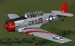
This is a repaint for the payware A2A Simulations AT-6 Texan. This repaint depicts the restored AT-6D 42-85696, registered N85696, owned by Paul Ehlen, based just outside Minneapolis at Flying Cloud airport in Eden Prairie, MN, and can be seen on public display at the Wings of the North Museum. This aircraft originally served as an instrument trainer at Craig Field, Alabama in 1945 and 1946. Between 2002 and 2006 the aircraft was fully restored by John Meyer and Gary Allen, of Lake Stevens, WA, and it is the most accurate/authentically-complete AT-6D flying today. The restored aircraft has a propeller spinner fitted, as some of the Craig Field AT-6D's did have spinners installed, based on period photos.
| Filename: | Craig_Field_North_American_AT6_Texan_N85696.zip |
| License: | Freeware |
| Added: | 12th April 2016, 10:58:56 |
| Downloads: | 256 |
| Author: | John Terrell |
| Size: | 22.74 MB |
| Category: Flight Simulator 2004 - Scenery | |
| PAMR - Merrill Field - Anchorage, Alaska - Texture Update |
|
Images related to this file:
File Description:
This texture for one of Sidney Schwarz's lights will prevent my Merrill Field scenery from generating blurred textures when you are flying nearby. It all depends on your settings within FS9 so you might never have had that problem, and if you haven't then you don't need this. If you have had that problem, and I did, then you really need this. Sid issued new textures some while ago, but unfortunately it wasn't known that his light was causing the problem until this week, and I never downloaded the new ones. I have also taken this opportunity to provide new AI with minor adjustment to levels for both Merrill and Lake Hood. These go into Scenery/World/Scenery and say yes to over-write.
| Filename: | PAMR__Merrill_Field__Anchorage_Alaska__Texture_Upd.zip |
| License: | Freeware, limited distribution |
| Added: | 9th May 2014, 19:44:48 |
| Downloads: | 295 |
| Author: | Roger Wensley |
| Size: | 142.42 KB |
© 2001-2026 AVSIM Online
All Rights Reserved
Privacy Policy |