
Where Flight Simulation Enthusiasts Gather from Around the World!
AVSIM Library - Search Results

| Category: Flight Simulator 2004 - Scenery | |
| Lake Athabasca Airfields in Alberta & Saskatchewan Canada |

|
Images related to this file:
File Description:
These are four airfields around or near Lake Athabasca, in Alberta and Saskatchewan. Fort Chipewyan CYPY is at the southwestern end of the lake and the direct recipient of pollution that flows north from the Tar Sands to the south. The population of around 850 lives in one of the earliest European settlements in Alberta, founded as a trading post by Peter Pond of the Northwest Company in 1788 and named for the Chipewyan people who lived in the area. The airfield has one runway aligned 03-21 and 5,000 feet of asphalt, with PAPI at both ends. The landclass has been modified along with the grassed area of the airfield to create the village on the lakeshore. There are scheduled flights and GA flights in the AI for all four airfields. Charlot River CJP9 is on the northern shore at the western end of the lake, in Saskatchewan. It serves a nearby hydroelectric project and is used to transport technical staff in and out. There is no terminal building, only waiting pickup trucks and a generator building. There is one lit gravel runway aligned 04-22 and just over 3,200 feet long. Fond-du-Lac CZFD is on the northern shore in Saskatchewan, at the narrower eastern end. The population is around 900 and is a remotely situated "fly-in" village that has existed for over 150 years where "living off the land" is an accepted and normal way of life. The village has been created along with the airfield. The single runway is 3,800 feet of lit gravel aligned 10-28 with PAPI at the western end. Stony Rapids CYSF is east of the end of Lake Athabasca, on the Fond du Lac River. It has a population of around 250 and is only semi-connected to the rest of Canada by a rough gravel road. The runway is over 5,000 feet of gravel, aligned 06-24 with PAPI at both ends. The NorthSKlake is a flatten for an Ultimate Terrain lake that was at an incorrect elevation.
| Filename: | Lake_Athabasca_Airfields_in_Alberta__Saskatchewan_.zip |
| License: | Freeware, limited distribution |
| Added: | 7th August 2018, 12:39:52 |
| Downloads: | 175 |
| Author: | Roger Wensley |
| Size: | 20.36 MB |
| Category: Flight Simulator 2004 - Scenery | |
| Burns Lake CYPZ in British Columbia, Canada |
|
Images related to this file:
File Description:
Burns Lake is 90 miles east of Terrace and 130 miles west of Prince George, on the eastern side of the Coast Mountains. The airfield is at 2343' ASL and the 11/29 runway is just over 7,000' of 75' wide asphalt. There are buildings, some of them new, around the apron at the west end of the runway and both JetA and 1100LL are available. There is also a weather station in a fenced area west of the apron. All apron buildings were modeled specifically for this scenery; there may be some missing if new construction has continued in the last three years.
| Filename: | Burns_Lake_CYPZ_in_British_Columbia_Canada.zip |
| License: | Freeware, limited distribution |
| Added: | 11th May 2011, 16:57:44 |
| Downloads: | 465 |
| Author: | Roger Wensley |
| Size: | 4.57 MB |
| Category: Flight Simulator X - Scenery | |
| FSX Scenery KLCH Lake Charles Louisiana USA |
|
Images related to this file:
File Description:
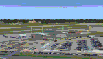
Complete new airport including up to date ADE, custom made buildings, terminal, control tower, and
hangars, some with transparent windows and interiors. Includes current FAA approaches.
Some scenery libraries required. I really liked the unique terminal and control tower at this airport.
By Dan French.
| Filename: | FSX_Scenery_KLCH_Lake_Charles_Louisiana_USA.zip |
| License: | Freeware, limited distribution |
| Added: | 18th July 2023, 14:31:28 |
| Downloads: | 111 |
| Author: | Dan French |
| Size: | 16.65 MB |
| Category: Flight Simulator X - Scenery | |
| Whistler/Green Lake Water Aerodrome - CAE5 (FSX) |
|
File Description:
Whistler’s Green Lake Water Aerodrome (as it is listed), can be a busy float plane center. At this writing, Google Earth shows a Twin Otter floating at the docks. I find this area to be one of my most favorite to fly in. All scenery objects are sourced from FSX Deluxe. VANCOUVER PLUS is required for this scenery to work.
| Filename: | WhistlerGreen_Lake_Water_Aerodrome__CAE5_FSX.zip |
| License: | Freeware, limited distribution |
| Added: | 16th April 2009, 05:05:30 |
| Downloads: | 1,259 |
| Author: | Will Jones |
| Size: | 5.97 MB |
| Category: Flight Simulator 2004 - Scenery | |
| W63 - Lake County Regional Airport - Virginia, USA |
|
Images related to this file:
File Description:
Created with Airport Design Editor by ScruffyDuck Software using current FAA documentation and Google Earth measurements, this package offers a replacement for FSX's stock airport. All these enhancements are as close to the real airport as I can get with stock library objects and custom models. Trees were removed from the approach end of Rwy. 22.
| Filename: | W63__Lake_County_Regional_Airport__Virginia_USA.zip |
| License: | Freeware |
| Added: | 12th August 2014, 10:00:14 |
| Downloads: | 80 |
| Author: | Wayne Roberts |
| Size: | 79.52 KB |
| Category: Flight Simulator 2004 - Scenery | |
| VFR of Lario, Area E2 - Como Lake, Italy (Update) |
|
Images related to this file:
File Description:
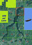
This 8th scenery covers approximately an area of 7.5x6 km, from S.Gregorio/Dongo (NW) to Colico (NE), and S.Siro (SW) to Tremenico/Aveno (SE) and includes six NLC piers: Dervio, Piona, Colico, Dongo, Musso, Pianello del Lario, in addition to the disused Cremia's one; a lot of dedicated buildings are included, as S.Tommaso of Canterbury church and fortification (Corenno), Cistercian abbey (Piona), pier and dock (Colico), S.Stefano church, factory buildings and airpollution control machinery (Dongo), Rezzonico's castle (S.Siro).
This VFR on Lario scenery includes several Dervio's details, and fully revises the previous Dervio scenery; Are included: Boldona's park office and stand, railway station, NLC shiphard, Pontile piers with Concordia steamer, dock bay with small floating pier and compass of the lake, S. Peter and Paul church and houses front of lake, hydro power station, Municipality and some other buildings, Castello's tower, windsurf school, windsurfers and kitesurfers on the lake, cross and Madonna on top of Legnoncino mountain. There are also included two viaducts between the tunnels of the freeway 36, with moted traffic. Catamarans Citta di Como and Tivano at Colico/Dongo piers together with other minor boats and docks alongside the lake coast; a moted regata with catamarans is placed in the lake between Pianello and Dervio.
This scenery SUPERSEDES AND CANCELS the previous "dervio_v2a" one, removed from the library. This is the eighth scenery of the "VFR of Lario" project, made with photorealistic terrain (multiseason & night) and with some 3D GMax realistic objects.
| Filename: | VFR_of_Lario_Area_E2__Como_Lake_Italy_Update.zip |
| License: | Freeware |
| Added: | 25th November 2012, 20:54:39 |
| Downloads: | 1,664 |
| Author: | Aldo Della Vedova, Daniele Lanfranchi, Gian Mario Verga |
| Size: | 39.39 MB |
| Category: Flight Simulator 2004 - Scenery | |
| Update - Terrain Mesh for Canada's Maritime Provinces |
|
File Description:
This package contains two files updating river and lake elevation for FS2002 and FS2004 in LOD09 terrain mesh (in Maritimes09a.zip and Maritimes09b.zip) for Canada's Maritime Provinces (including also Newfoundland, parts of Labrador and Saint-Pierre-et-Miquelon).
| Filename: | Update__Terrain_Mesh_for_Canadas_Maritime_Province.zip |
| License: | Freeware, limited distribution |
| Added: | 1st September 2003, 01:52:28 |
| Downloads: | 4,244 |
| Author: | Gilles Gauthier |
| Size: | 12.86 KB |
| Category: Flight Simulator X - Aircraft Repaints, Textures and Modifications | |
| Bumi Air Beechcraft Baron 58 |
|
Images related to this file:
File Description:
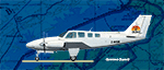
A texture set for the default FSX Beech Baron 58 depicting Z-WSM (real aircraft is Baron 55) of Bumi Air that operates between Harare (FVCP or FVHA) and Bumi Hills on the shores of Lake Kariba.
| Filename: | Bumi_Air_Beechcraft_Baron_58.zip |
| License: | Freeware |
| Added: | 6th July 2013, 19:14:01 |
| Downloads: | 167 |
| Author: | Graeme Swart |
| Size: | 981.44 KB |
| Category: Flight Simulator X - Scenery | |
| FIX for "Lago de Valencia" |
|
File Description:
This is a small fix for elevation problem on Valencia's Lake (Lago de Valencia) in Venezuela
It's a early version so I will add small islets in the future.
Please, see the picture to understand the problem.
| Filename: | FIX_for_Lago_de_Valencia.zip |
| License: | Freeware, limited distribution |
| Added: | 3rd September 2008, 23:38:34 |
| Downloads: | 942 |
| Author: | Alexander Garzon |
| Size: | 72.53 KB |
| Category: Flight Simulator 2002 - Scenery | |
| British Columbia Bush Scenery: Grant Narrows & Rambo's Hideout |
|
File Description:
The larger runway at Grant Narrows has a 15 degree bend, and the shorter runway is on a slope that involves an unconventional downhill landing & an uphill take-off (STOL planes only!). Both strips are bumpy, and require Holger Sandmann's mesh of the Lower Mainland of Southern British Columbia (bcmesh9c.zip) for the required effect. A dock is provided down on the lake shore for visitors on floats. The landing strips are fictional, set in an area of wilderness on the shores of Pitt Lake - but only 20 miles from downtown Vancouver. The first Rambo movie was filmed in the hills just to the east in the Golden Ears Provincial Park: if you fly north from Grant Narrows you'll find Rambo's airstrip hideout just a couple of miles past the end of the lake - the real life location of a popular fishing lodge. Also requires Gerrish Gray's trees (trees_v3.zip).
| Filename: | British_Columbia_Bush_Scenery_Grant_Narrows__Rambo.zip |
| License: | Freeware, limited distribution |
| Added: | 13th March 2003, 21:26:06 |
| Downloads: | 946 |
| Author: | James Belk |
| Size: | 1.74 MB |
© 2001-2026 AVSIM Online
All Rights Reserved
Privacy Policy |