
Where Flight Simulation Enthusiasts Gather from Around the World!
AVSIM Library - Search Results

| Category: Flight Simulator 2002 - Scenery | |
| OLBA2002 Beirut International Airport Update V1.1 |

|
File Description:
This is the update 1.1 for OLBA2002 the new scenery by Lebor. You will need to download the initial scenery package lebor_olba2002.zip before installing this update. This update fixes many issues in the original release. OLBA2002 scenery represents Beirut International Airport in Lebanon. The scenery features highly detailed hand painted airport layout, 3D custom objects, custom textures and AFCAD file. A Landclass and a coastline file are also included to improve Beirut city around OLBA.
| Filename: | OLBA2002_Beirut_International_Airport_Update_V11.zip |
| License: | Check within download |
| Added: | 11th January 2003, 17:20:14 |
| Downloads: | 5,812 |
| Author: | Lebor (Michel Karam) |
| Size: | 75.56 KB |
| Category: Flight Simulator X - Scenery | |
| Paraguana Airport (SVJC) - Venezuela |
|
Images related to this file:
File Description:
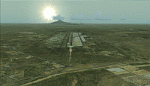
Josefa Camejo International Airport, located in Las Piedras
near the city of Punto Fijo, in western Venezuela.
This scenery add facilities Amuay refinery, the world's largest.
Includes some interesting special effects, like the explosion of a transformer
at the airport every hour o'clock and smoke effects in the refinery.
With photo-terrain scenery from satellite imagery in Google Earth.
Includes terminal building and hangars with realistic
textures from images obtained from Internet.
Also includes a friendly Auto-Install.
| Filename: | Paraguana_Airport_SVJC__Venezuela.zip |
| License: | Freeware |
| Added: | 11th September 2011, 20:59:37 |
| Downloads: | 1,924 |
| Author: | David Maldonado |
| Size: | 79.54 MB |
| Category: Flight Simulator X - Scenery | |
| SLLP |
|
File Description:
SLLP
El Alto International Airport (Spanish: Aeropuerto Internacional El Alto) (IATA: LPB, ICAO: SLLP) is an international airport located in El Alto, near the city of La Paz, in the La Paz Department of Bolivia. It serves national and international air traffic. The facility served as a focus city for the former Lloyd A���©reo Boliviano, Bolivia's national air carrier, and is a hub for Aerosur, currently the country's largest private airline.
| Filename: | SLLP.zip |
| License: | Freeware |
| Added: | 24th February 2011, 23:38:13 |
| Downloads: | 4,545 |
| Author: | Anwar Gonzalez |
| Size: | 26.7 KB |
| Category: Flight Simulator 2004 - AFCAD Files | |
| PAYA Yakutat, Alaska, USA |
|
File Description:
Googlyafcad A&F Data for Yakutat, based on Google Earth satellite data.
Unfortunately, Microsoft have only limited facilities at this airport in Flight
Simulator 2004 with no provision for commercial traffic and this file will allow
you and your "AI" traffic to land, taxi, park and take off in a realistic manner.
Yakutat airport sees regular flights by Boeing 737 jets of Alaska Airlines, along
with smaller-sized traffic by local operators such as Arctic Circle Air Service
| Filename: | PAYA_Yakutat_Alaska_USA.zip |
| License: | Freeware |
| Added: | 5th August 2008, 08:29:27 |
| Downloads: | 528 |
| Author: | John Hinson |
| Size: | 63.18 KB |
| Category: Flight Simulator 2004 - Scenery | |
| Ultimate Malta - Landclass, Mesh, Roads and Towns |
|
File Description:
With this file you will get one of the best freeware sceneries for the island of Malta, including:
----- a more realistical landclass mixed with green grounds and southern dry grounds ----- Important roads around the airport ----- a more realistical mesh with small mountain, cliffs and beaches ----- Important towns that do not exist in FS2004 inlc. the capital of Malta, villages around the airport as well as the harbor town in the very south of Malta and some important ones more -----
| Filename: | Ultimate_Malta__Landclass_Mesh_Roads_and_Towns.zip |
| License: | Freeware |
| Added: | 7th September 2008, 22:59:31 |
| Downloads: | 4,546 |
| Author: | Dave Sheffield |
| Size: | 38.14 KB |
| Category: Flight Simulator 2004 - Scenery | |
| Male International Airport |
|
File Description:
Male is the capital city of the Republic of Maldives. Which is a country located in the Indian Ocean to the West of Sri Lanka and to the South of India. This country is made up of hundreds of small islands. This is a famous tourist destination in Asia.
Airport of Male is also an island (which is artificially expanded to make it suitable for the
airport.) which is at Northeast of the capital city Male (island).
| Filename: | Male_International_Airport.zip |
| License: | Freeware |
| Added: | 16th June 2004, 23:24:05 |
| Downloads: | 19,975 |
| Author: | Arjuna Chiththananda |
| Size: | 5.65 MB |
| Category: Flight Simulator X - Scenery | |
| Jacksonville, FL - Jacksonville International Airport (KJAX) |
|
Images related to this file:
File Description:
After a long wait for imagery to become available on the internet for the new terminal at KJAX, this airport scenery has been completed. Major airline gate assignments are real. Generic floating buildings have been replaced with custom and library objects. Landclass changes, roads, rework of runways, taxiways and aprons, placement of library objects and a library of new airport buildings are included. Scenery in this package is based on Virtual Earth (Bing) and Google Earth imagery.
| Filename: | Jacksonville_FL__Jacksonville_International_Airport_KJAX.zip |
| License: | Freeware |
| Added: | 24th September 2011, 02:01:06 |
| Downloads: | 5,743 |
| Author: | Art Poole |
| Size: | 2.42 MB |
| Category: Flight Simulator X - Scenery | |
| YBLT - Ballarat Aerodrome - Victoria, Australia |
|
Images related to this file:
File Description:
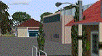
YBLT (Ballarat Aerodrome) is a regional 'airport' in the central west of the State of Victoria, Australia and utilises infrastructure from the days of RAAF operations which lasted till the early 1960's. Thus the buildings are now a bit outdated but this file does not reflect that as I have not done any custom texturing so everything in this package tends to look a bit new and crispy.
Note the name of this 'airport'. The locals are adamant it is an aerodrome, not an airport. I have not found any freeware or commercial offerings for an alternative to the default and so I have put one together.
This is a reasonable approximation of the airport /aerodrome but is not entirely accurate as the hangars/buildings I have modelled myself are generic ones I have done and do not look exactly like the ones at that facility. The connecting road is not in true alignment as I have created it so as it blends into the surrounding default scenery.
| Filename: | YBLT__Ballarat_Aerodrome__Victoria_Australia.zip |
| License: | Freeware |
| Added: | 21st October 2014, 01:51:16 |
| Downloads: | 841 |
| Author: | Robert Budd |
| Size: | 4.43 MB |
| Category: Navigation and ATC - Navigation | |
| LSZS - Samedan visual approach chart v3 |
|
Images related to this file:
File Description:
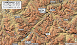
Custom made visual approach chart and pilot's briefing for Engadin (St. Moritz) Samedan LSZS airport in Switzerland, Europe's highest elevation airport (5,600 ft.) situated in the Swiss Alps. This airport is a day VFR operations only and has no instrument approach due to extreme terrain around it. A demanding visual descent into a canyon, in between steep rising terrain, is required to make the visual approaches for both runways with a steep 4.4* degrees final approach portion guided by the PAPI's. Still, executive jets up to Boeing 737(BBJ) size approach the airport often in the winter peak season VFR with these procedures. It is designed as per real operators' pilot briefing for Samedan. Real airport's full pilot briefing document also included. The real airport's excellent briefing (included) intentionally does not contain the maneuvers needed for the approach of jets through the mountains but only reporting points for all and maneuvers for light aircraft only. This gap is what this chart covers. Version 2 chart included better graphics and refined visual procedure for jets and version 3 now includes real pilot's briefing guide.
| Filename: | LSZS__Samedan_visual_approach_chart_v3.zip |
| License: | Freeware, limited distribution |
| Added: | 20th March 2015, 23:35:11 |
| Downloads: | 2,026 |
| Author: | Kyprianos Biris |
| Size: | 7.1 MB |
| Category: Prepar3D V1-4 - Scenery | |
| Telluride United States N37 56'21 W107 48'59 |
|
File Description:
Telluride United States N37 56'21 W107 48'59 Telluride is the county seat of the county and the most populous city of San Miguel County in the southwestern part of the US state of Colorado at the end of a gigantic canyon located Telluride, Colorado (8,750ft), a national historical landmark surrounded by the highest concentration of 13,000 'and 14,000' peaks in the United States. The city is a former silver mining camp on the San Miguel River in the western mountains of San Juan, a major center for winter sports. Telluride is more accessible than ever, as more flight options have been added for the 2017-18 winter season. Charlotte Douglas International is the last airport added to the list of direct flights to the Montrose-Telluride Regional Airport (MTJ) which brings the total of 15 non-stop flights (16 during the holiday season) from 12 major hubs to the 2017 - 18 winter. In the scenery you will find the city of Telluride and the airport infrastructure of the Charlotte Douglas International airport.
| Filename: | Telluride_United_States_N37_5621_W107_4859.zip |
| License: | Freeware |
| Added: | 11th March 2018, 00:23:20 |
| Downloads: | 152 |
| Author: | Pasquale Marrulli |
| Size: | 407.63 KB |


© 2001-2026 AVSIM Online
All Rights Reserved
Privacy Policy |