
Where Flight Simulation Enthusiasts Gather from Around the World!
AVSIM Library - Search Results

| Category: Navigation and ATC - Navigation | |
| FS Pilot's Guide-Washington |

|
File Description:
This is my Pilot's Guide for Washington State. I adapted this to work with the FS9 Kneeboard from the PDF version available for free from the Washington State Department of Transportation website. The guide includes all public and state operated airports in Washington.
| Filename: | FS_Pilots_GuideWashington.zip |
| License: | Freeware |
| Added: | 10th November 2004, 07:03:30 |
| Downloads: | 911 |
| Author: | Eric Norton |
| Size: | 12.5 MB |
| Category: Navigation and ATC - Navigation | |
| FS Pilot's Guide-Washington, Update |
|
File Description:
This is an updated README text file containing the corrected instructions on setting up my Pilot's Guide. Be sure to read thoroughly!!
| Filename: | FS_Pilots_GuideWashington_Update.zip |
| License: | Freeware |
| Added: | 16th November 2004, 01:16:20 |
| Downloads: | 492 |
| Author: | Eric Norton |
| Size: | 1.61 KB |
| Category: Navigation and ATC - Navigation | |
| Updated Georeferencing Data for Matt Fox's Sectional and TAC Charts |
|
File Description:
These files provide updated georeferencing information for all of the TAC and Sectional Charts of the United States that I uploaded to AVSIM a few months ago. This might be useful if you want to import these into some kind of moving map. Not needed just to view the maps.
| Filename: | Updated_Georeferencing_Data_for_Matt_Foxs_Sectiona.zip |
| License: | Freeware |
| Added: | 7th October 2004, 23:14:37 |
| Downloads: | 1,240 |
| Author: | Matt Fox |
| Size: | 32.41 KB |
| Category: Navigation and ATC - Navigation | |
| Flight Time Calculator International |
|
File Description:
This very visual program allows you to calculate (when flying in IFR) your flight time quickly according to the wind speed/direction, your plane heading and speed and the flight distance.
You can switch between kilometric and nautic miles system with the right button of the mouse anywhere in the window. Everything is calculated on the fly.
Very simple program but handy because it tells you all you need to know about your flight time.
Version 1.5.0 features:
# The plane drift displayed was the maximum drifting and not the real drifting. Both are calculated now.
| Filename: | Flight_Time_Calculator_International.zip |
| License: | Freeware |
| Added: | 21st July 2005, 01:15:10 |
| Downloads: | 1,113 |
| Author: | Franck KRIEGER |
| Size: | 1.63 MB |
| Category: Navigation and ATC - Navigation | |
| Israel CVFR waypoints |
|
File Description:
All VFR in the state of Israel is conducted under the CONTROL of ATC; hence the acronym "CVFR" for "Controlled Visual Flight Rules." Israel has a special set of waypoints for CVFR, which do not appear in the standard GPS. The charts which do show these waypoints are in Hebrew. I do not read Hebrew, but Yuval Elbaz provided me with some data that translates the Hebrew names into Roman characters. Using this data, I have created a file which will put the waypoints into your Flight Simulator, so that they show up on your map and GPS.
| Filename: | Israel_CVFR_waypoints.zip |
| License: | Freeware |
| Added: | 1st August 2005, 23:33:00 |
| Downloads: | 749 |
| Author: | David Wilson-Okamura |
| Size: | 7.1 KB |
| Category: Navigation and ATC - Navigation | |
| Los Angeles ARTCC charts from AIRAC 0505 - Volume 3 of 5 |
|
File Description:
This collection of US Terminal Procedures has been assembled to provide a complete set of charts for flight simulation use within the Los Angeles ARTCC region, on behalf of VATSIM's Los Angeles ARTCC (ZLA), whose website can be found at http://www.laartcc.org
**THIS IS VOLUME 3 OF 5** Charts are in Adobe PDF format.
Volume 3 = ZLA_AIRAC0505_CA_OUTLYING.ZIP
Features procedure charts for all appropriate California airports outside the combined Southern California Terminal Radar Approach Control facility "SoCAL", but under the limited ATC responsibility of the Los Angeles Center facility, and includes amongst others:
KSBA - Santa Barbara Airport (Class C)
KPSP - Palm Springs Airport (TRSA)
KBFL - Bakersfield Meadows Field (Class D)
KCMA - Camarillo Airport (Class D)
KOXR - Oxnard Airport (Class D)
KSMX - Santa Maria Public / Hancock Field (Class D)
KSBP - San Luis County Regional (Class D)
KMHV - Mohave Airport (Class D)
KVCV - Victorville Airport (Class D)
KTRM - Jacqueline Cochran Regional Airport
L35 - Big Bear Airport
16 other California outlying fields in LA Center airspace.
| Filename: | Los_Angeles_ARTCC_charts_from_AIRAC_0505____Volume.zip |
| License: | Freeware |
| Added: | 15th May 2005, 18:05:53 |
| Downloads: | 499 |
| Author: | Mark Coldwell |
| Size: | 27.18 MB |
| Category: Navigation and ATC - Navigation | |
| 1 in 60 Rule |
|
File Description:
An extensive Power Point presentation for hellenic flightsimmers in Greek language that explains all basics about the theory and applications of the "1 in 60 rule".
The Zip package contains the power point 2003 viewer and all necessary files that eliminate the need of having the power point application installed.
| Filename: | 1_in_60_Rule.zip |
| License: | Freeware |
| Added: | 4th June 2005, 18:36:50 |
| Downloads: | 1,131 |
| Author: | Manolis Argyropoulos |
| Size: | 3.98 MB |
| Category: Navigation and ATC - Navigation | |
| Israel IFR Charts |
|
File Description:
Contains three charts for IFR flying to and within Israel: low-level, high-level, and Tel Aviv terminal area. Charts are in Adobe Acrobat format (PDF) and have been cropped to fit Israel and its immediate environs on one sheet of paper. Source: Europe/North Africa/Middle East (ENAME) enroute charts L-16, H-13, and T-2, supplied online by the National Geospatial-Intelligence Agency.
| Filename: | Israel_IFR_Charts.zip |
| License: | Freeware |
| Added: | 7th August 2005, 23:51:56 |
| Downloads: | 719 |
| Author: | David Wilson-Okamura |
| Size: | 9.94 MB |
| Category: Navigation and ATC - Navigation | |
| Papua New Guinea Charts 2 of 3 |
|
Images related to this file:
File Description:
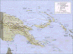
Calibrated for FSMap, but scanned images can be used in other map software, such as FSM Moving Map (FSMMM) by Rana Hossain. Chart source: Topographic Maps U.S. Army Map Service, Series T504, original scale 1:250,000, date 1964-. Courtesy of the University of Texas Libraries, The University of Texas at Austin. Missing: I could not find equivalent charts for New Britain; for this island, a lower-quality chart is included.
| Filename: | Papua_New_Guinea_Charts_2_of_3.zip |
| License: | Freeware |
| Added: | 7th May 2010, 10:45:02 |
| Downloads: | 797 |
| Author: | David Wilson-Okamura |
| Size: | 34.63 MB |
| Category: Navigation and ATC - Navigation | |
| IFR Enroute High Alt Charts for Moving Map Application |
|
Images related to this file:
File Description:
IFR ENROUTE HIGH ALTITUDE chart chunks from the late 2009 charts, formatted in the lat/long geographic coordinate system for GPS, moving map application for flight simulation use.
These chart chunks were converted to the JPEG format for compatibility and size. Coverage is the lower 48 H-series divided into 45 JPEG tiles from a full mosaic. Included is the needed projection files and world files.
The images are customized for moving map display (see link), and included is a Legend in PDF format.
Note: This type of map is an equal grid and no further calibration is needed, for users of FSM Moving Map, just mass import, done.
| Filename: | IFR_Enroute_High_Alt_Charts_for_Moving_Map_Applica.zip |
| License: | Freeware |
| Added: | 13th April 2010, 19:11:17 |
| Downloads: | 329 |
| Author: | David Myers |
| Size: | 88.99 MB |
© 2001-2026 AVSIM Online
All Rights Reserved
Privacy Policy |