
Where Flight Simulation Enthusiasts Gather from Around the World!
AVSIM Library - Search Results

| Category: Flight Simulator 2004 - Miscellaneous Files | |
| Airline Inventory Update #3 |

|
File Description:
(Update 3 - 9 January 2006) Not long ago I embarked on a project to streamline my flight simulator's AI setup. I knew I had too many aircraft texture sets that I was not using, too many unnecessary night texture files, installation of defunct airlines, and the like. So, I put together
a spreadsheet showing my AI system with all the airlines and additional pieces such as vehicles and ships. This has been a very large and time-consuming project as my AI system has more than 7,000 texture sets, more than 2,200 airline folders, and other assorted AI components. Inside you'll find an Excel spreadsheet with all my airlines (more than 2,200) listed, Birds, Blimp, Corporate Aircraft, Defunct Airlines, Douglas DC-3, Float Planes, Government Aircraft, Helicopters, Medical Aircraft, Military Aircraft, Personal Registration Aircraft, Ships, and Vehicles - all associated with the FS AI system. In addition, I've included the spreadsheet's source text files for those that do not have Microsoft Excel. NOTE: You can download an MS Excel spreadsheet viewer (freeware) from the Microsoft site. Because of copyright restrictions and the size of my AI system, I have not provided links to specific files. However, I think you'll find the data very useful. See the readme file for a list of possible sources and contact information. NOTE: Changes since the last update are reflected in "green" text. Frank Bass
| Filename: | Airline_Inventory_Update_3.zip |
| License: | Freeware |
| Added: | 9th January 2006, 21:43:00 |
| Downloads: | 458 |
| Author: | Frank Bass |
| Size: | 234.76 KB |
| Category: Flight Simulator 2004 - Miscellaneous Files | |
| Airline Inventory Update #4 |
|
File Description:
(Update 4 - 13 January 2006) Not long ago I embarked on a project to streamline my flight simulator's AI setup. I knew I had too many aircraft texture sets that I was not using, too many unnecessary night texture files, installation of defunct airlines, and the like. So, I put together a spreadsheet showing my AI system with all the airlines and additional pieces such as vehicles and ships. This has been a very large and time-consuming project as my AI system has more than 7,000 texture sets, more than 2,200 airline folders, and other assorted AI components. Inside you'll find an Excel spreadsheet with all my airlines (more than 2,200) listed, Birds, Blimp, Corporate Aircraft, Defunct Airlines, Douglas DC-3, Float Planes, Government Aircraft, Helicopters, Medical Aircraft, Military Aircraft, Personal Registration Aircraft, Ships, and Vehicles - all associated with the FS AI system. In addition, I've included the spreadsheet's source text files for those that do not have Microsoft Excel. NOTE: You can download an MS Excel spreadsheet viewer (freeware) from the Microsoft site. Because of copyright restrictions and the size of my AI system, I have not provided links to specific files. However, I think you'll find the data very useful. See the readme file for a list of possible sources and contact information. NOTE: Changes since the last update are reflected in "green" text. Frank Bass
| Filename: | Airline_Inventory_Update_4.zip |
| License: | Freeware |
| Added: | 13th January 2006, 17:20:30 |
| Downloads: | 512 |
| Author: | Frank Bass |
| Size: | 235.36 KB |
| Category: Flight Simulator 2004 - Original Aircraft | |
| Grumman Albatross version 2.1 |
|
Images related to this file:
File Description:
Grumman HU-16 Albatross 2.1
Greg Pepper, Michael Verlin
May 18, 2012
I am privileged to be honored with the custodianship of this model.
Greg Pepper is no longer with us. I wish to honor his memory and I've made a few modifcations to enhance this aircraft.
WHAT'S NEW FOR 2.1
The flight model is the most significant change. The flight model has been enhanced by the use of Jerry Beckwith's AirWrench.
The performance of the Albatross is now much closer to the parameters published for it. I've also adjusted the contact points for the hull.
Please make sure you adjust the fuel and payload before flying. This is a very heavy aircraft, and will be very sluggish if you attempt flight with full tanks and a full payload.
I've also added a few liveries, and modified several others. The colors and lettering of the U.S. Navy versions have been revised. The font the Navy uses is USN Long Beach. The paint colors are accurate now as well. You will also find new spin prop textures.
I've also slightly revised the original U.S. Air Force HU-16B and two of the U.S. Coast Guard liveries.
New for this release: U.S. Navy VXE6 UF-1L triphibian that served in the Antarctic, Chalk's G-111 and two new private liveries.
Michael Verlin
May 18, 2012
[email protected]
| Filename: | Grumman_Albatross_version_21.zip |
| License: | Freeware, limited distribution |
| Added: | 19th May 2012, 05:08:32 |
| Downloads: | 3,468 |
| Author: | Greg Pepper Michael Verlin |
| Size: | 88.13 MB |
| Category: Microsoft Flight Simulator (2020) - Aircraft Repaints, Textures and Modifications | |
| MF_P-38_Hollywood Hepcat |
|
Images related to this file:
File Description:
This folder contains a repaint for the Lockheed P-38L Lightning by Flying Iron. It shows Hollywood Hepcat' P-38J, numéro de série 42-31383, piloté par 2nd.
Le lieutenant Dwight M. Kelly, du 339th Fighter Squadron, 347th Fighter Group, 13th Air Force, en 1944, de Sterling Field dans les îles Salomon.
I was inspired by Ron Cole's magnificent painting: https://roncole.net/products/p-38-lightning-hollywood-hepcat-by-ron-cole?_pos=1&_sid=2b9efd2ac&_ss=r
where you can find superb painting on his site. https://roncole.net/
Repaint by Martial FÉRON, based on the textures by Flying Iron.
INSTALLATION
1. Unzip to a temporary location.
2. Copy the "MF_P-38_Holliwood Epcat" folder in this download to your "Community" folder in MSFS2020.
3. Have fun flying!
ACKNOWLEDGEMENTS
The model and textures used for this repaint were made by Fying Iron.
LEGAL STUFF
This repaint is released as FREEWARE. You may use and modify it in any way you wish, but
you may NOT use it in any kind of money-making endeavor, and you may NOT publicly
distribute any copies of it, whether modified or not, without my permission.
Martial FÉRON
CONTACT
Questions and/or comments about this repaint are always welcome via e-mail at [email protected].
April 2022
| Filename: | MF_P38_Hollywood_Hepcat.zip |
| License: | Freeware |
| Added: | 15th April 2022, 15:02:15 |
| Downloads: | 29 |
| Author: | Martial FÉRON |
| Size: | 56.72 MB |
| Category: Flight Simulator 2004 - Scenery Design | |
| FSDEM 1.1 |
|
File Description:
FSDEM is a graphical tool designed to help on the editing and correction of NASA SRTM (Shuttle Radar Topography Mission) terrain elevation meshes, and to create terrain mesh scenery to be used in Microsoft Flight Simulator 2002/2004.
Program main features:
This version fixes some bugs and adds minor improvements. See the included file history.htm for details.
| Filename: | FSDEM_11.zip |
| License: | Freeware, limited distribution |
| Added: | 4th August 2004, 20:51:02 |
| Downloads: | 5,125 |
| Author: | Emerson de Oliveira |
| Size: | 377.03 KB |
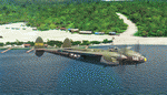
| Category: Flight Simulator X - Aircraft Repaints, Textures and Modifications | |
| Douglas C-47 (79001) Swedish Air Force |
|
Images related to this file:
File Description:
This folder contains a repaint for version 3.14 of the Douglas C-47 by Manfred Jahn and colleagues in the colors of C-47B 79001 of the Swedish Air Force that was at the start of the Catalina affair (Swedish: Catalinaaffären), a military confrontation and Cold War-era diplomatic crisis in June 1952, in which Soviet fighter jets shot down two Swedish aircraft over international waters in the Baltic Sea. The first aircraft to be shot down was an unarmed Swedish Air Force Tp 79, a derivative of the Douglas DC-3, carrying out radio and radar signals intelligence-gathering for the National Defence Radio Establishment. None of the crew of eight was rescued. The second aircraft to be shot down was a Swedish Air Force Tp 47, a Catalina flying boat, involved in the search and rescue operation for the missing DC-3. The Catalina's crew of five was saved. The Soviet Union publicly denied involvement until its dissolution in 1991. The aircraft was manufactured in 1943 with original US serial number 42-5694, and was delivered to USAAF 15th Troop Carrier Squadron (61st Troop Carrier Group). It saw action in northern Africa before being stationed at RAF Barkston Heath. On June 13, 1952, it disappeared east of the isle of Gotska Sandön while carrying out signals intelligence-gathering operations for the Swedish National Defence Radio Establishment. Both aircraft were located in 2003, and the DC-3 was salvaged, and the wreckage is currently on display in the Swedish Air Force Museum near Linköping. Repaint by Jan Kees Blom for Manfred Jahn's C-47 version 3.14, based on the paintkit by Gman5250.
| Filename: | Douglas_C47_79001_Swedish_Air_Force.zip |
| License: | Freeware |
| Added: | 17th August 2018, 16:34:03 |
| Downloads: | 238 |
| Author: | Jan Kees Blom |
| Size: | 11.55 MB |
| Category: Flight Simulator 2004 - Scenery | |
| Bethel: St Mary's area airfields in southwest Alaska close to the Yukon River |
|
Images related to this file:
File Description:
This presumes you have already installed Bethel PABE and Bethel Local Airfields. In the Yukon River area of Alaska to the north of Bethel there are small villages, served by flights from both Bethel and the nearer St Mary's PASM. St Mary's has a gravel runway like the other villages, but has a larger population and airport services including maintenance and fuel. This, plus the saving of an average one hundred miles of flying by a Cessna 205 when compared with flights from Bethel, means it acts as a distribution centre fed from Bethel by larger aircraft. Go to "http://vfrmap.com/" for free vfr maps of the area (see the attached). The ten village airfields included here are all to the north and west of St Mary's: Hooper Bay PAHP, Chevak VAK, Cape Romanzof PACZ (closed air force field servicing a radar station), Scammon Bay SCM, Sheldon Point SXP, Alakanuk AUK, Emmonak PAEM, Kotlik 2A9, Mountain Village MOU, and of course St Mary's PASM itself. With these airfields not everything is as it appears to be. For instance, Hooper Bay is not a new and modernised airfield, despite the asphalt runway and apron; the current version has dispensed with the aging asphalt and gone back to gravel. I have tended to go for the 2005 or so versions, which sometimes means a small runway amid or close to the housing; Kotlik was an early renewal for reasons of safety as much as anything else and has had (since 2003?) a new and longer runway located outside of the town. The second batch of airfields will be to the east of St Mary's.
| Filename: | Bethel_St_Marys_area_airfields_in_southwest_Alaska.zip |
| License: | Freeware, limited distribution |
| Added: | 29th April 2019, 17:07:24 |
| Downloads: | 226 |
| Author: | Roger Wensley |
| Size: | 11.53 MB |
| Category: Flight Simulator X - AFCAD Files | |
| FSX North Korea DMZ, UGF and Ballistic Missile Base Addon Scenery Package |
|
Images related to this file:
File Description:

I titled this a "DMZ, UGF and Ballistic Missile Base" scenery package because that's how this whole project started, but then it SNOWBALLED onto 80+ scenery areas for ALL of North Korea!
This package includes scenery AFCADs for 2 DMZ "Border Wall Areas", 8 DMZ SAM/EW radar sites (TacPack users can "spawn" SA-2s there!), 5 "secret" ballistic missile bases, two "secret" UnderGround Facility (UGF) locations like "TOPGUN 2", 5 navy bases/dockyards along the east coast, 2 nuclear facilities, 2 machine factories, and an Oil Refinery.
BUT WAIT! For the city of Pyongyang I added the Pyongyang Thermal Power Plant, the Pyongyang-Dong Power Plant, 2 power grid "sub stations" with SA-6 SAM sites, the Pyongyang rail yard, and the "VIP Airport" on the SE side of the city.
THERES MORE! (somebody STOP me!) I also did 23 fighter bases along with 12 helicopter bases (grass strips), and ALL of the fighter & helicopter bases have active runways, taxiways, and plenty of "Mil_Combat" parking available for AI aircraft.
For those who like "Carrier Ops", I put 4 "Naval Waypoints" off the coast of N Korea...2 in the Yellow Sea and 2 in the Sea of Japan. ALL FOUR have static aircraft carriers at their locations, or you can spawn/start an AI Carrier there instead!
Installation is SUPER easy and I've included instructions to install this SUPER-SIZED package as a stand-alone "Scenery Area" in your FSX Scenery Library. That way you can just click it on or off as needed, instead of clogging up your "Addon Scenery/Scenery" file with 200+ AFCAD files!
| Filename: | FSX_North_Korea_DMZ_UGF_and_Ballistic_Missile_Base.zip |
| License: | Freeware |
| Added: | 14th March 2024, 00:59:31 |
| Downloads: | 153 |
| Author: | Daniel Gregory |
| Size: | 22.5 MB |
| Category: Flight Simulator 2004 - Aircraft Repaints, Textures and Modifications | |
| JetBlue 'Circles' Airbus A320 |
|
Images related to this file:
File Description:
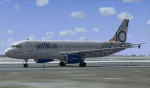
This repaint is of the very unusual but striking "JetBlue - Circles" livery for the Project Airbus A320 model (included in zip). This is a complete file and for FS9 (FS2004). While it may work in FSX, I cannot and will not confirm that as these textures have only been tested in FS9. All repainted textures, which were completely hand painted (other than the JetBlue text) have been saved and formatted in 32 bit. This model comes with all of the standard PA animations. New Alpha channels have been created to highlight the detail which has also been highlighted in terms of the doors and windows to resemble the actual aircraft. This has been an intense repaint to do due to the very nature of the livery so please PLEASE DO NOT count the circles and email me to say I missed one. If I have (which I haven't I don't think) pretend it is due to excessive weathering :) While there are some screen shots here, there are more in the Read Me file so if you have any doubts, please take a look at all of them. Installation, Distribution and Contact Details for me can be found in the enclosed PA TC Read Me File. Enjoy this paint and download it lots just so I know the work, frustration, a bottle and half of Capt Morgan and lots of Asprin were worth it :) Cheers and safe flying!
| Filename: | JetBlue_Circles_Airbus_A320.zip |
| License: | Freeware, limited distribution |
| Added: | 11th March 2012, 19:40:09 |
| Downloads: | 594 |
| Author: | Tony Cannon, Project Airbus |
| Size: | 13.54 MB |
| Category: Flight Simulator 2004 - Scenery | |
| PABA - Barter Island (Kaktovik) - Alaska North Slope 8 |
|
Images related to this file:
File Description:
The town of Barrow is in the far north of Alaska, and these are coastal villages or radar installations to the west, south, and now east of Barrow. There will be further additions. Barter Island is a DEW station Air Force base 310 miles east of Barrow and 75 miles east of Bullen Point. The runway is just under 5,000 feet of gravel and aligned 06-24 on a spit of land at the northeast corner of the island. The big hangar is still there on the apron. Most of the DEW buildings have now been removed but this scenery is dated around 2005 when there were more of them still there. Between the DEW station and the airstrip is the village of Kaktovik, with a population of some 300 mainly traditional Inupiat. The village was first pioneered when the DEW station was built in the 1950's and grew as the years passed. The FS9 error discovered when making this scenery was that FS9 had mistakenly "placed" Kaktovik at Bullen Point (not physically, it was just wrongly stated as the local town); this is now only partly corrected as FS9 refused to accept my Bullen Point revision but allowed me to associate Kaktovik with Barter Island. Kaktovik is definitely on Barter Island. I could also mention that the runway was in the sea, but there isn't much point in that as Bill would say it was all the fault of Ultimate Terrain, so I won't bother. The next DEW station to the east is in Canada and called Komakuk; this has already been made and posted. The next in this series will be far to the west. The AI has daily flights by ERA, plus Northern Air Cargo, and some GA.
| Filename: | PABA__Barter_Island_Kaktovik__Alaska_North_Slope_8.zip |
| License: | Freeware, limited distribution |
| Added: | 19th July 2016, 17:49:16 |
| Downloads: | 208 |
| Author: | Roger Wensley |
| Size: | 3.42 MB |
© 2001-2026 AVSIM Online
All Rights Reserved
Privacy Policy |