
Where Flight Simulation Enthusiasts Gather from Around the World!
AVSIM Library - Search Results

| Category: Flight Simulator 2004 - Miscellaneous Files | |
| Active ILS - LEBL (El Prat - Barcelona Airport) |

|
File Description:
As most know initiating the ILS at certain airports for AI Traffic or the User Aircraft is not a function at this time when using AFCAD2. If you add a new ILS runway to an airport such as LEBL (El Prat/Barcelona 7R/25L) only the user aircraft can use this runway (without ATC commands) when visibility falls below 3 miles. ATC will no longer use this runway for AI Traffic because FS9 sees it as a visual runway. This will cause ATC to vector all your AI Traffic back to runway 7/25 old numbers, 7L/25R new numbers which is also a Terminal departure runway. This ILS bgl file adds all NAVAIDS for making 7R/25L a Precision Instrument Runway by adding all the radar fixes for both the ILS approach portion and the missed approach procedures, altitudes and intersections as per current published plates. All AI Aircraft/User Planes will now continue to use the new 7R/25L runway when Airport weather conditions are less than 3 miles. ATC will also use the right naming/numbers of the runways. The DME/VOR approaches have also been written using the new BCN/PRA VOR's for runways 7L/25R and 02. Many different default FS9 scenery GUID's added including Taxiway Signs *** FS2004 Default Scenery AFCAD2 included with the new 7R/25L runway ***
| Filename: | Active_ILS__LEBL_El_Prat__Barcelona_Airport.zip |
| License: | Freeware, limited distribution |
| Added: | 30th December 2004, 17:53:42 |
| Downloads: | 2,842 |
| Author: | Jim Vile |
| Size: | 31.51 KB |
| Category: Flight Simulator 2004 - Scenery | |
| Z19O - Hamat Airbase - Batroun, Lebanon |
|
Images related to this file:
File Description:
Hamat is a village near the coast of Lebanon, around 25 miles north of Beirut. The airport runway was built during the civil war to the west of Hamat in the late 1970's, between Hamat and another village called Wuajh Al Hajar. The intention was have an alternative to Beirut airport, which could be (and often was) closed by shell fire from any or all of the sides involved in the civil war, or by bombing by those who were not directly part of the civil war but occasionally joined in. It has been used for drag racing, occasional freefall parachuting (this may continue) and is now an army base with mostly helicopter use. The runway is around 5,600 feet of asphalt, 90 feet wide and aligned 02/20. There is no lighting. The apron is set well back from the runway and has hangars at each end; one set is four hangars long, and at the other end of the apron there are three hangars. There are also the remains of some radar to the west of the apron, bombed (in 1982?). The runway has been repositioned and the surrounding landclass modified to reduce one village to it's approximate actual size and to create a second village which was missing entirely. An intrusive road has been deleted, and the airfield grass area also modified.
| Filename: | Z19O__Hamat_Airbase__Batroun_Lebanon.zip |
| License: | Freeware, limited distribution |
| Added: | 23rd May 2015, 10:03:10 |
| Downloads: | 224 |
| Author: | Roger Wensley |
| Size: | 8.53 MB |
| Category: Flight Simulator X - Scenery | |
| RAF Kirton in Lindsey - Lincolnshire, England |
|
File Description:
It appears to have been an RAF habit (inherited from the RFC to name its bases after the nearest railway station, possibly to simplify the process of issuing Rail Warrants to personnel posted there. By that token, the site should be RAF Kirton Lindsey, Kirton Lindsey being the name of the nearby railway station constructed in 1849. No.255 Squadron's Operations Record Book (ORB) consistently uses that version of the name. So does the airfield's separate ORB, from the date of the site's WWII creation (15 May 1940) through to May 1941. After mid-1941 and the departure of No.255 Squadron, use of RAF Kirton-in-Lindsey. Kirton in Lindsey begins to appear in the site's own records – eventually dominating.
On 25 March 2013 it was announced to dispose of the airfield and technical facilities with only accommodation remaining. The airfield used to host No. 1 Air Control Centre (1ACC), the RAF’s only deployable ground-based early warning and air control radar unit, which was parented by RAF Scampton
The Station has had a varied selection of personnel occupying it, the RFC, RAF, USAAF, and before becoming an RAF Station for the last time it was the home of the Royal Artillery Regiment responsible for operating the Rapier sam. The Station finally closed in 2013.
| Filename: | RAF_Kirton_in_Lindsey__Lincolnshire_England.zip |
| License: | Freeware |
| Added: | 29th October 2015, 23:44:17 |
| Downloads: | 161 |
| Author: | Terry Boissel |
| Size: | 19 KB |
| Category: Flight Simulator X - Aircraft Repaints, Textures and Modifications | |
| Project Airbus A321 FD-FMC version 1.20 <b>FSX and P3D</b> |
|
Images related to this file:
File Description:

A321 FD-FMC is a freeware FMC project, only for FSX and P3D, based on Project Airbus A321 aircraft with enhanced VC, which provide real vertical navigation feature and all Airbus autopilot advanced modes (all knobs like real Airbus : Push-pull). FD-FMC has a unrealistic interface, to be easy to use, but it offers true vertical navigation in N1 mode with adaptive pitch control. Aircraft pack include an airport database (more than 200 airports) and new airports procedure files are created each month and can be downloaded. This database include real SID, STAR and approach procedures. FD-FMC manages altitude and speed constraint, holding pattern, DME-ARC, ILS/LOC/RNAV approaches, autolanding, LOC back course mode, multiple gradient approaches. You can set easily all performance in FMC pages, for Take off, climb, descent and approach. VC fully functional, with all system (Bleeds system, fuel system, Fly by wire). All switches working. ND with Radar terrain (TAWS) and basic TCAS (traffic). All real airbus autopilot mode works and reported on the PFD's FMA : THR CLB, CB, SRS, DES THR IDLE, etc ......Flight can be saved (update automatically FSX flight plan file) and all FMC data are saved.
Flight begin in cold and Dark; Real Start engine procedure.....Please, read the install manual and user manual English and French). A very advanced Airbus panel. FD-FMC is copyright Francois Dore.
| Filename: | Project_Airbus_A321_FDFMC_version_120_bFSX_and_P3D.zip |
| License: | Freeware |
| Added: | 4th April 2016, 21:46:09 |
| Downloads: | 2,574 |
| Author: | Francois Dore - Project Airbus |
| Size: | 327.24 MB |
| Category: Flight Simulator 2004 - Miscellaneous Files | |
| Airline Inventory |
|
File Description:
Not long ago I embarked on a project to streamline my flight simulator's AI setup. I knew I had too many aircraft texture sets that I was not using, too many unnecessary night texture files, installation of defunct airlines, and the like. So, I put together a spreadsheet showing my AI system with all the airlines and additional pieces such as vehicles and ships. This has been a very large and time-consuming project as my AI system has more than 7,000 texture sets, more than 2,200 airline folders, and other assorted AI components. Inside you'll find an Excel spreadsheet with all my airlines (more than 2,200) listed, Birds, Blimp, Corporate Aircraft, Defunct Airlines, Douglas DC-3, Float Planes, Government Aircraft, Helicopters, Medical Aircraft, Military Aircraft, Personal Registration Aircraft, Ships, and Vehicles - all associated with the FS AI system. In addition, I've included the spreadsheet's source text files for those that do not have Microsoft Excel. NOTE: You can download an MS Excel spreadsheet viewer (freeware) from the Microsoft site. Because of copyright restrictions and the size of my AI system, I have not provided links to specific files. However, I think you'll find the data very useful. See the readme file for a list of possible sources and contact information. Frank Bass
| Filename: | Airline_Inventory.zip |
| License: | Freeware |
| Added: | 6th December 2005, 17:45:39 |
| Downloads: | 1,274 |
| Author: | Frank Bass |
| Size: | 229.85 KB |
| Category: Flight Simulator 2004 - Aircraft Repaints, Textures and Modifications | |
| JASDF YS-11FC_V2.7 |
|
File Description:
YS-11FC of JASDF Flight Check squadrons.
YS-11 JASDF colour scheme textures only,for AFG`s YS-11 v2.7 ONLY,you must have the AFG YS-11jac.zip for the V2.7 in fs9.in order for these textures to work.
also included are the aircraft config text,that needs to be added to the aircraft.cfg file.for the aircraft to show in fs9.
JASDF Flight Check aircraft where painted with ref to photos i could find,on airliners.net,and a web site for JASDF aircraft,the textures have been updated to the correct colour shade of red,thanks to Esa Kaihlanen of AFG,in order for me to correct some details i had wrong.
also thanks go to Esa of AFG,for pointing me to the correct web site with JASDF squadron details.
The aircraft will show in fs9 as [Japan air force 151 V2.7] [Japan air force 154 V2.7]and [Japan air force 160 V2.7].
You can chose weather or not to have all three in your aircraft folder or not,just make sure you match the cfg file with the texture file you decide to use.
Original textures and model by AFG,JASDF textures where done by me alan cottrill,if you have any problems with the JASDF textures,then please contact me.
| Filename: | JASDF_YS11FC_V27.zip |
| License: | Freeware |
| Added: | 12th November 2006, 10:59:16 |
| Downloads: | 791 |
| Author: | Alan Cottrill |
| Size: | 14.22 MB |
| Category: Flight Simulator 2004 - Aircraft Repaints, Textures and Modifications | |
| United (Post-CO Merge) Boeing 747-400 |
|
Images related to this file:
File Description:
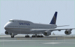
This is a repaint in one of the new "United" liverie's for the PAYWARE SMS Overland 747-400W model. This is a TEXTURES ONLY file so the SMS Overland aircraft will be required. The textures have been thoroughly tested in FS9 (FS2004) only. Will they work in FSX? "I don't know so trying them in FSX is done at your discretion. This version of the United livery is complete with customized alpha channels covering the fuselage (complete) and wings giving the plane a crisp, clean new look. All animations are as per the SMS model along with the various shadowing for the plane. This, I believe (and I could be wrong here and possible am :) ) is a very accurate rendition of one of the new United liveries for a very nice (affordable) payware model - if you don't have it, it is a worth looking at, especially if you are not interested in reading a 500 page manual before you can fly but want a MUCH better model than the default one. All Distribution, Installation and contact Details for me can be found in the SMS TC Read Me File enclosed. Enjoy her and happy, safe flying to all whether you down this file or not :)
| Filename: | United_PostCO_Merge_Boeing_747400.zip |
| License: | Freeware |
| Added: | 4th March 2012, 02:31:24 |
| Downloads: | 537 |
| Author: | Tony Cannon and SMS Overland |
| Size: | 5.08 MB |
| Category: Flight Simulator 2004 - Scenery | |
| OSM World: Western Europe |
|
Images related to this file:
File Description:
Read Installation instructions carefully, this is a complex scenery package!
This package includes a "Dev Kit" should you wish to expand it to other areas! Please contact me if you wish to do so! This is community effort! If we all contribute, we will hopefully have the entire world covered one day!
Welcome to OSM World: Western Europe! This is a vector data scenery package covering the western European area. Coastlines, Rivers, lakes, roads, railways, and power lines with detail never before seen! All in an autogen-compatible density! You can see roundabouts, train terminals, harbor areas in a resolution of a point every 10 meters. At this same resolution a vectorial city class places residential (in small and big building variations, depending on surface area) and industrial areas exactly where they are supposed to be. This gives the city areas a resolution far superior to the capacity of FS-2004 default landclass bitmaps, limited to approximately 1 Km x 1 Km squares. OSM World: Western Europe will even give you small roads leading to small towns (even a few houses across)! From big highway intersections, including ramps, to the tiniest rural pathways covering the entire western area! Wherever in Western Europe you fly, there is something to see!
| Filename: | OSM_World_Western_Europe.zip |
| License: | Freeware |
| Added: | 13th October 2014, 00:18:39 |
| Downloads: | 4,140 |
| Author: | Mario Noriega |
| Size: | 274.75 MB |
| Category: Flight Simulator 2002 - Scenery | |
| Palisades SRTM Altitude Mesh |
|
File Description:
Ever wanted to fly down the VFR corridor over the Hudson River and gawk at all the skyscrapers in New York City? ... in your dreams! The Department of Fatherland Security has closed it down.
But, we still have Flight Simulator. Unfortunately, the altitude mesh for this area is somewhat lacking in detail.
This Palisades altitude mesh remedies that. Covers the Palisades cliffs, of course (but no Amusement Park, sniff), and also Riverside, Morningside, and Washington Heights, and Fort Tryon. In fact, all 5 Boroughs of New York City are covered, as well as most of central and northern New Jersey (visit beautiful downtown Hoboken!), and the larger part of Long Island. Also Rockland, Westchester, Orange, Putnam counties and more. And even Bear Mountain State Park.
Approximate coverage: N40* to N42* and W73* to W75*.
Made from NASA Shuttle Radar Topography Mission data (3 arc-second resampled to LOD9 - horizontal resolution of 76.4 meters) using SRTM to BGL by Matthew Styles (available in the AvSim library.) Very easy to use - give it a try.
BONUS: includes simple instructions so that anyone can make altitude mesh for their area from SRTM data using SRTM to BGL by Matthew Styles. Sorry, SRTM data only available for the Americas at the moment. The rest of the world coming soon. Check inside for more details.
No support of any kind is offered for this package - very sorry.
| Filename: | Palisades_SRTM_Altitude_Mesh.zip |
| License: | Freeware |
| Added: | 12th June 2003, 16:09:26 |
| Downloads: | 2,165 |
| Author: | Luis, scenery design forum |
| Size: | 3.48 MB |
| Category: Flight Simulator 2004 - Miscellaneous Files | |
| Active ILS - LEBL Simwings/New Spanish Airports (El Prat - Barcelona Airport) |
|
File Description:
This file is made for Barcelona LEBL Aerosoft/Simwings FS9's New Spanish Airports. As most know initiating the ILS at certain airports for AI Traffic or the User Aircraft is not a function at this time when using AFCAD2. If you add a new ILS runway to an airport such as LEBL (El Prat/Barcelona 7R/25L) only the user aircraft can use this runway (without ATC commands) when visibility falls below 3 miles. ATC will no longer use this runway for AI Traffic because FS9 sees it as a visual runway. This will cause ATC to vector all your AI Traffic back to runway 7/25 old numbers, 7L/25R new numbers which is also a Terminal departure runway. This ILS bgl file adds all NAVAIDS for making 7R/25L a Precision Instrument Runway by adding all the radar fixes for both the ILS approach portion and the missed approach procedures, altitudes and intersections as per current published plates. All AI Aircraft/User Planes will now continue to use the new 7R/25L runway when Airport weather conditions are less than 3 miles. ATC will also use the right naming/numbers of the runways. The DME/VOR approaches have also been written using the new BCN/PRA VOR's for runways 7L/25R and 02. Many different default FS9 scenery GUID's added including Taxiway Signs. *** FS2004 Simwings Barcelona Scenery AFCAD2 included with the new 7R/25L runway ***
| Filename: | Active_ILS__LEBL_SimwingsNew_Spanish_Airports_El_P.zip |
| License: | Freeware, limited distribution |
| Added: | 31st December 2004, 04:59:21 |
| Downloads: | 3,943 |
| Author: | Jim Vile |
| Size: | 32.52 KB |
© 2001-2026 AVSIM Online
All Rights Reserved
Privacy Policy |